Analysis of Developments in the Space Domain
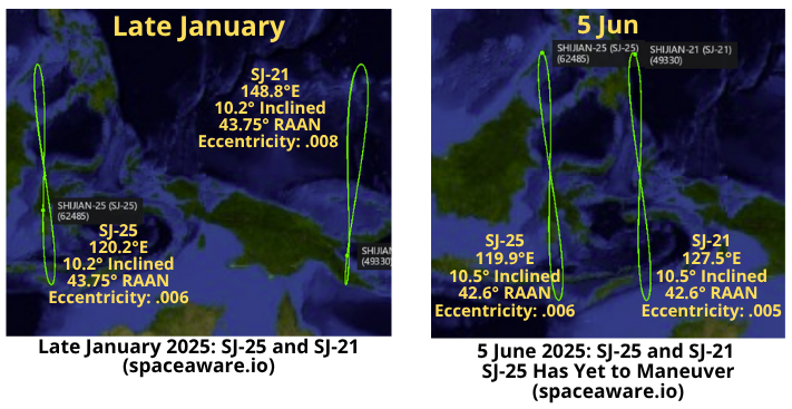
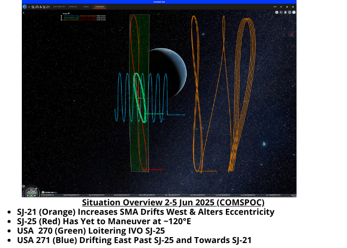
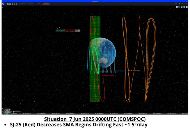
2-7 June: China is maneuvering both SJ-21 (49330) and SJ-25 (62485) in order to conduct the world’s first refueling experiment in Geosynchronous orbit. As of 6 Jun the satellites are on orbital trajectories will have them in close proximity on ~11 June. China has stated SJ-25 is an on-orbit service test vehicle, specifically a refueling satellite. SJ-21 captured and hauled away a piece of space debris in GEO back in January 2022. The US has placed TWO of its GSSAP satellites (USA 270 <41744> & USA 271 <41645>) in position to observe. Watch COMSPOC Video Link of maneuvers from 2-5 June. See Jack Anthony’s explanation of “How to Rendezvous With Another Satellite.” China appears to be following this playbook exactly!
Timeline:
– Prior to 2 June 2025 the last time China maneuvered SJ-21 was in July 2023.
– From COMSPOC: “SJ-21 used a total of ~25 m/s of delta V and it got roughly halfway to SJ-25. Odd that they would stop – meaning, if they were only going to go halfway, why go so fast and use so much fuel? Perhaps the remaining fuel onboard 21 is not a concern.”
Editor’s Note: For those Thank you to the COMSPOC team for their fantastic collaboration!
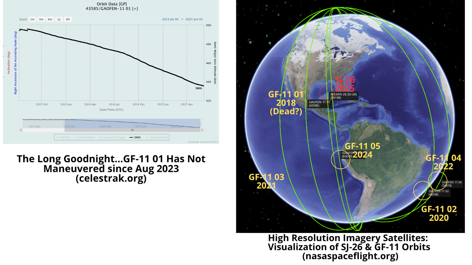
29 May: China launched a Long March-4B containing the Shijian-26 (SJ-26) (64199) satellite from Jiuquan. China releases few details regarding its Shijian experimental satellites, in this case official sources noted a remote sensing mission stating, “the satellite is mainly used for national land surveys, environmental management and other fields, providing information services to support national economic development”. SJ-26’s orbit inclination and average altitude is typical for imagery related satellites and is nearly identical to the orbit of China’s 5 Gaofen-11 imagery satellites. Launch Video.
– SJ-26 is in a sun-synchronous orbit (SSO) with an average altitude of 496.6km and an inclination of 97.5°.
– SJ-26’s orbit closely resembles that of the Gaofen-11 series of high resolution optical imagery satellites (43585, 46396, 49492, 54818, 60249). All 5 of the Gaofen-11 satellites were also launched on a LM-4B, however the launches were from Taiyuan and not Jiuquan.
– Like SJ-26 all of the GF-11 satellites are in sun-synchronous orbits and inclined at ~97.5° with an average altitude of ~496km.
– GF-11 01 has not maintained its orbit since August 2023 and may have reached its end of life. Its average altitude has slowly declined over the past 2 years and the satellite now has an average altitude of 436km (see graph below).
– China’s official description of GF-11 is also very similar to that used for SJ-26: “(GF-11) will be used in a variety of fields including land surveys, urban planning, road network design, crop yield estimation and disaster relief”.
– Previously, Chinese officials have stated that of the 14 Gaofen satellites variants “1-7 are civilian satellites, and 8-14 are military satellites.” The same official also noted “The best satellite in the U.S. is Keyhole. Its resolution is 0.1m. Our Gaofen 11 can also meet this standard.”
– Without additional information, such as a high resolution image, the mission and capabilities will remain unknown. SJ-26 was developed by the Harbin Institute of Technology while GF-11 satellites were made by CAST.
-Placing SJ-26 in a similar orbit as the GF-11 satellites may provide China with an opportunity to compare results as they test whatever new technology is on the SJ-26.

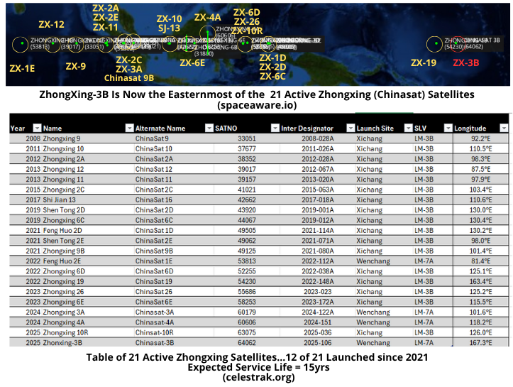
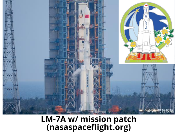
20 May: China launched a Long March-7A with the ZhongXing-3B (ChinaSat-3B) (64062) communications satellite from Wenchang. According to official sources, the satellite entered the planned orbit and “will provide voice, data, radio and television transmission services”. After spending ~10 days in GTO, Chinese space operators circularized ZhongXing-3B’s orbit in GEO and the satellite is now over the equator at 167.3°E. At its current location ZhongXing-3B is the furthest East of any of the ZhongXing/ChinaSat satellites. Launch Video.
– ZhongXing-3B is in Geostationary orbit and is inclined 0.0°. It is currently 3.9° further east than Zhongxing-19 which China launched in 2022.
– Zhongzing-3B’s location will likely provide greater and more resilient connectivity in the Western & Central Pacific regions.
– Per Andrew Jones: “ChinaSat satellites are generally described as commercial or civilian assets. However, some of them—particularly the lower-numbered in the series—likely have military or intelligence applications, such as secure communications for the People’s Liberation Army (PLA). The absence of public information and imagery raises the possibility that ChinaSat-3B serves military users.”
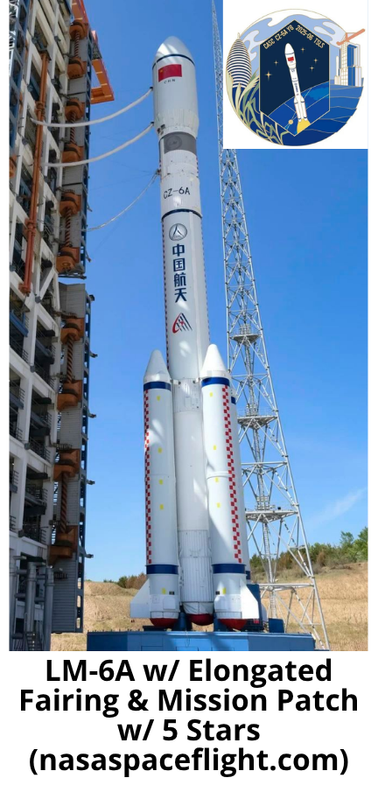
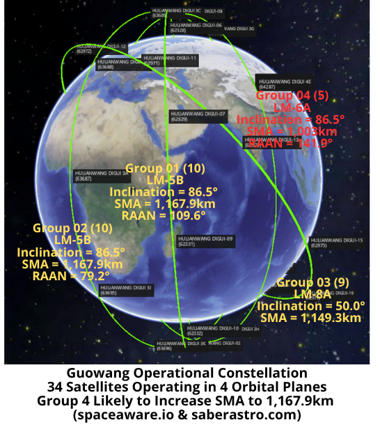
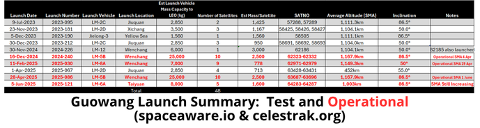
5 Jun: China launched a Long March-6A with the fourth group of Guowang (SatNet LEO Group 04) satellites from Taiyuan. According to official sources, the satellites entered the preset orbit successfully. Consistent with previous Guowang launches, Chinese officials did not provide information on the number of satellites, nor any details about the satellites’ capabilities. The 18 Space Defense Squadron has cataloged 5 satellites (64283-64287) and 1 LM-6A Rocket Body. Nice going 18 SDS! Launch Video.
– With this launch there are now 34 satellites in the operational Guowang constellation. Additionally, China has launched 14 Guowang test satellites. (see table and graphic)
– Per Andrew Jones report: “The China Academy of Space Technology (CAST)…stated in December (2024) it had developed large and small satellite platforms for Guowang, without disclosing functional differences.”
-Given the maximum lift to LEO capacity of the LM-6A of ~8,000kg these 5 satellites are likely the smaller variant.
– All of the Group 04 satellites are in 86.5° inclined orbits and are at an average altitude of ~1,003km. They will likely increase their average altitude to 1,067.9km to match the 20 other Guowang satellites in 86.5° inclined orbits.
– The Group 4 satellites have a ~32.3° east RAAN offset with the Group 1 satellites. The Group 1 satellites themselves have a 30.4° east RAAN offset with the Group 3 satellites. (see graphic)
– Per Andrew Jones:
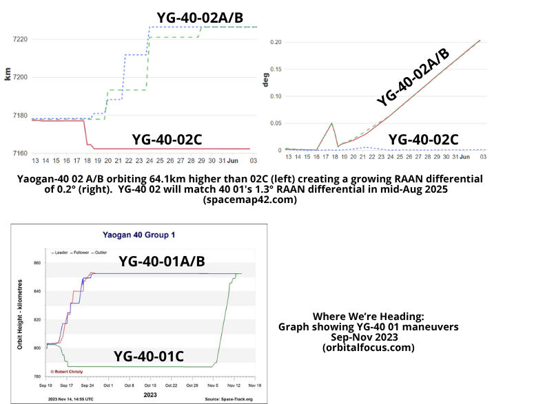
3 Jun: China is in the process of maneuvering its three Yaogan-40 02A-C (63918-20) satellites to form an equilateral triangle formation. The satellites launched into the same 86.0° inclination as the YG-40 01A-C triplets (57830-32). This inclination will allow China to monitor the Arctic and Antarctic regions. The two sets of triplets are not co-planar as the YG-40 02 satellites are offset ~72° west of YG-40 01.
Two of the satellites (63918 & 63919) increased their average altitude after launch from 802km to ~850km which is the operating altitude of the YG-40 01 triplet. The remaining satellite (63920) decreased its average altitude from 802km to 787km and is drifting west relative to the other two satellites. Once 63920 reaches the desired RAAN offset Chinese space operators will increase its average altitude to join the other two satellites. Once co-altitude the satellites will maintain their relative distance from one another forming an equilateral triangle.
The RAAN offset for the YG-40 01 triplets is 1.3°. The current RAAN offset for YG-40 02 is only 0.2°. At their current rate (daily RAAN differential is .015°/day) YG-40 02 will achieve 1.3° RAAN differential in ~73 days or 15 Aug 2025. Stay tuned to see if our prediction proves correct.
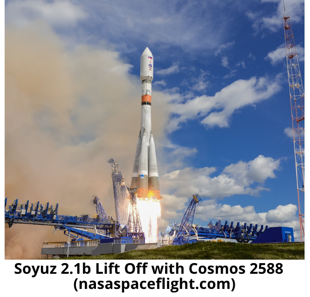
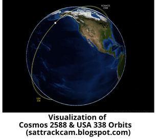
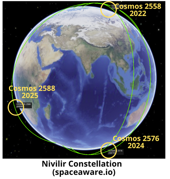
23 May: Russia launched a Soyuz 2.1b with a Fregat upper stage carrying the Cosmos 2588 satellite into Low Earth Orbit. The Fregat upper stage was used to maneuver the satellite from its launch inclination of 67° to 73°. The maneuver resulted in Cosmos 2588 being nearly co-planar with a high value US reconnaissance satellite, USA 338. This is the fourth instance in which Russia has launched a Nivilir satellite into a co-planar orbit with US reconnaissance satellites. Currently, Cosmos 2558 (53323), Cosmos 2576 (59773) and Cosmos 2588 are all nearly co-planar with USA 326, USA 314 and USA 338 respectively. Launching into a co-planar orbit enables Russia to conduct proximity operations (with potential counterspace capabilities) with minimal fuel expenditure and little warning. See Jack Anthony’s “How to Rendezvous With Another Satellite”. Not great. For MUCH more information on the Nivilir please read Bart Hendrickx latest articles (Part 1 & Part 2) in the Space Review. Note: Orbital information on the USA satellites is not available in the public space catalog, however it is available via other non-governmental sources. Launch Video.
– Cosmos 2588 is currently in a 479 x 463km orbit with an inclination of 73°. By comparison Cosmos 2558 is 452 x 459km and 97.2° inclination and Cosmos 2576 is at 490 x 482 and 97.4° inclination.
– Per Breaking Defense article: “in its current orbit, Cosmos 2588 will pass as close as 93.9 kilometers (58.3 miles) from its target (USA 338).”
– Per Slingshot Linked In post: “As the objects are at different altitudes and assuming there are no further maneuvers, the objects will have a ‘fly-by’ roughly every 4 days, leading to repeated close approaches.” Video!
– Russia likely conducted an operational test of a counterspace satellite with Cosmos 2519 and its sub-satellites, Cosmos 2521 & Cosmos 2523, from July 2017 – June 2018. (see next article)
– Per Dr Marco Langbroek:
– Per Bart Hendrickx:
Editor’s Comment: It’s getting pretty sporty up there.
The United States has accused Russia of conducting on-orbit counterspace testing in the past. Testing thus far has not resulted in the creation of space debris. Below is an excerpt from the most excellent Secure World Foundation (SWF) 2024 Global Counterspace Capabilities Report describing the activities of Cosmos 2519 and its sub-satellites, Cosmos 2521 & Cosmos 2523, from July 2017 – June 2018.
Cosmos 2519

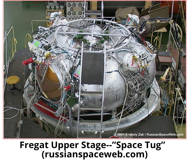
This essay will introduce the process of a “chaser” spacecraft (maybe a refueler servicing vehicle) goes through to arrive at the “target” spacecraft (the one who ordered the refueling). The terms chaser and target have been used by NASA way back as they planned and executed rendezvous, then loitered around the other spacecraft, that’s called proximity operations, and then they would dock. Some call this ZPO, zero prox ops. This process involves maneuvering the chaser and hopefully the target is cooperative and not maneuvering without telling you.
The chaser’s orbital elements provide information into how the rendezvous mission progressing If you are not aware of the target, following this trend will help resolve that. It’s the change and matching of the chaser’s elements to the target’s elements that give insight into how the process is moving along. In the end, if the chaser is to dock with the target, then the orbital elements must match. There are three phases to completing a RPO and then ZPO. While the chaser’s maneuvers may not always follow the expected flow of these phases, they provide a framework to follow along. Here below is a table that summarizes the 3 phases. Give it a review and study before reading on, it will be helpful.
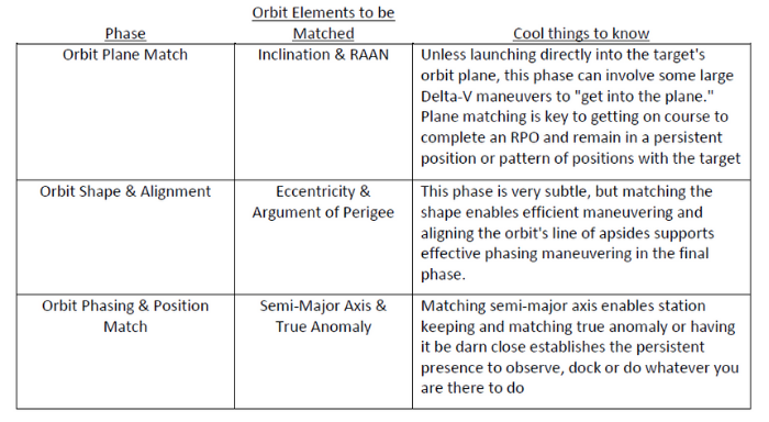
Let’s look at each phase and go a little deeper to give you insight into what’s going on.
Orbit Plane Matching: Plane matching usually occurs early in planning and executing a mission. The launch vehicle usually does it all, you launch right into the orbit plane of the target (see Russia’s Kosmos 2558 and 2576). But there can be errors in that insertion and thus orbit plane matching maneuvers are needed. Below is a simple illustration (all my drawings are simple😁) that shows the red and blue orbits have different inclinations and RAANs. So, the task at hand to match orbit planes would be to execute a Delta V where that star is and get the orbit planes matched to have same inclination and RAAN. A really important step to ensure when you get close for proximity operations you are not zig zagging back and forth.
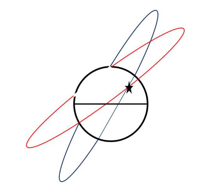
The chaser can do a series of small orbit plane adjust maneuvers to incrementally get the orbit planes aligned. As you all remember from the Orbital Element Series of articles I wrote, the orbit plane is characterized by the inclination and RAAN. The amount of Delta-V to align inclination only gives us some basic rules of thumb. In GEO, 53 m/s of Delta-V is needed to change or correct 1 degrees of inclination, for LEO it’s about 115 m/s. But remember, you got to also get the RAAN lined up. That can be costly in propellant. Here’s an example: You launched into a 97.4 degrees incline LEO orbit. Nailed the inclination. But, the RAAN is not aligned, it’s off by 1.5 degrees. How much Delta-V do you think is needed to fix that? Hummmm? Well, its 197.5 m/s, wow! Now, get ready for some learning, what if the inclination was 28 degrees. Is there a difference in what’s needed to fix the 1.5-degree error in RAAN? Yup, it’s only 97 m/s. Still, a lot. So, orbit plane matching usually is the launch vehicles chore, but if you need to tweak things to get the orbit planes aligned, that can cost you fuel (and time making PowerPoints to explain what’s going on…LOL).
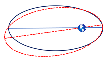
Orbit Shaping & Alignment: Normally mission planners like to have the long axis of the orbits matched, this is called the line of apsides. It enables efficient maneuvering. This can be a very subtle stage, usually the orbits are so near circular this phase may not occur. Orbit shaping is reflected in the eccentricity and argument of perigee matching. Hopefully the launch vehicle did its job getting things properly inserted into orbit. Of course, if the target starts playing games and maneuvering, then this problem gets tougher. The illustration on the next page shows that the red dashed orbit and the blue orbit do not have their lines of apsides lined up. Some planners would want to execute a maneuver to get them aligned to support more efficient maneuvering.
Orbit Phasing: This is my favorite phase. This is where you get to close in on the target and hang out with them or better yet, dock and refuel them. This phase is usually seen as where the chaser orbit is being adjusted and we see changes in its orbit’s apogee and perigee. They are fiddling with the semi-major axis and getting the approach going, perhaps slowing down the relative closer rate. As semi-major axis getting close to a match, chances are the true anomaly is also closing in. Match them up and you can reach out and shake hands or get set for the dock and refueling. Here’s a cool rule of thumb I think you’ll enjoy knowing and sort of relates to phasing. For LEO Earth orbits, there is a 10:1 rule, my friend James Oberg at NASA/JSC came up with it. Here’s what it means. If you are 1 Km below your target orbit and you are plane matched and circularized, then you will advance 10Km forward each orbit period. Thus 10:1. So, let’s say you are 5 Km below and 150 Km behind. Let’s say your orbit periods are really close and 90 minutes. OK, so when will you be right underneath the target? Well, use the 10:1 rule. Each orbit you scoot ahead relative to the target 50 Km (5 Km times 10). So, we are 150 Km behind, and guess what? In 3 orbit or 4.5 hours we can look “up” and see the target. Pretty cool, the 1- to 1 rule of thumb by James Oberg. Yay for him!
Well, there you have it. The 3 phases of RPO and some details as to what’s going on. You may ask, how does Jack know this stuff? Well, two folks play a BIG role in helping me understand and get all enthusiastic about RPO. Dr Chirold Epp helped me in the early 1980’s. While at Johnson Space Center I’d meet with Dr Epp and he’d tell me all the cool things Shuttle would be doing with regard to RPO. He helped me understand the math and art to all this. Then Mr. A. Clark Keith III came along in 1989 as my Aerospace Corporation advisor for the famous TAOS space mission that flew 1994-2000. I got to know Clark and one of his finest hours (or years) was the XSS-11 RPO test mission that flew 2005-2007. Clark was the Flight Director and he wrote up notes that comprised a “how to” handbook for RPO. Just before his battle with cancer took him from us in 2013, Clark wrote up his notes and gave them to his colleague Jim Baker to publish. I met with Clark just before he passed and he said “Jack’s I’m writing everything down, make sure you read and live it.” Clark’s experience, insight, and ability to explain things was awesome and helped all of us know the ways to achieve RPO. He is the Father of Military RPO. He played a huge role in planning the ANGELS mission and many more space test missions. I miss Clark and thank him. DO YOU HAVE A MENTOR HELPING YOU UNDERSTAND YOUR AREA OF RESPONSIBILITY? I BET YOU DO.
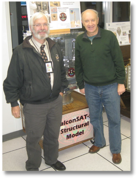
Here’s a photo of Clark and I in 2011 at the USAF Academy FalconSAT Operations Center. He loved coming to meet with the cadet’s and talk spaceflight!