issue 109| 11 NOV 2024
The integrity flash
Analysis of Developments in the Space Domain
in this issue
9 Nov: China launched a Long March-2C with four PIESAT-2 (PIESAT-2 01~04) satellites from the Jiuquan. The PIESAT-02 01-04 satellites will be “mainly used for SAR imaging, with high-precision imaging capability”. China previously launched PIESAT-1 01-04 (56153-56156) satellites on 30 March 2023. The PIESAT spacecraft orbit in close formation to achieve greater imagery resolution. No orbit information was available for the PIESAT-2 satellites as of 11 November 2024. Launch Video.
– The PIESAT-2 satellites are part of the “Zhuzhou Constellation” which, when completed, will be composed of 16 small SAR satellites. While not stated, there will be a total of 20 PIESAT satellites on orbit, the first 4 may be considered test spacecraft.
– PIESAT-2 orbital information is not yet available.
– PIESAT-1 and PIESAT-2 are X-band radar remote sensing (X-SAR) satellites.
-We have previously examined the PIESAT-1 formation. The 4 satellites, consist of one 320-kilogram pivot satellite and three 270-kg assistant satellites. It appears the Pivot Satellite maintains its orbit while the other 3 seem to rotate along its axis. This is consistent with prelaunch renderings. Watch Video.
– The four PIESAT-1 satellites form a single module. The module consists of one main satellite and three sub-satellites oriented around the main module. The main satellite will act as the transmitter, while the three passive satellites are the receivers.
– The 4 PISAT-1 satellites continuously operate within 1km of one another demonstrating the ability to maintain formation.
– Zhuzhou Space Interstellar Satellite Technology Co., Ltd. plans to launch another 4 PIESAT satellites December 2024 and another 8 satellites before March 2025.
– Once the constellation is complete the time interval between two consecutive observations of the same location will be ~2.5 hours.


China’s Yaogan-43 Satellites: A Closer Look
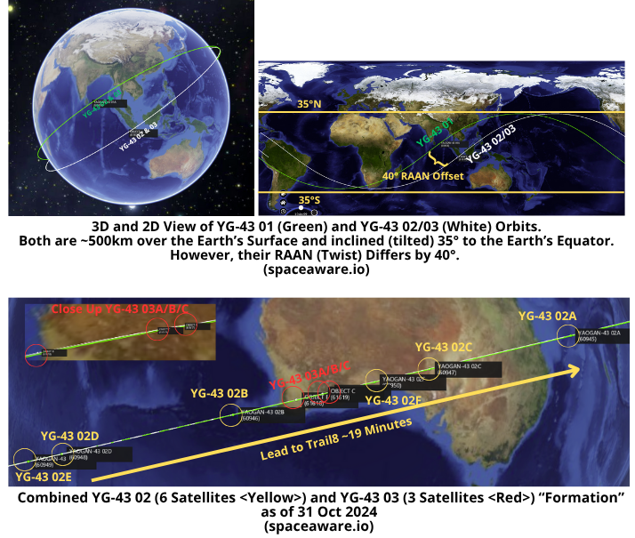
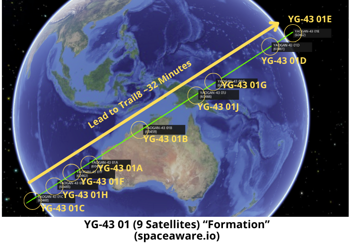
6 Nov: China has conducted 3 launches containing Yaogan-43 (YG-43) satellites. All launches were from China’s Xichang launch facility. The first launch occurred on 3 Aug 2024 and placed 9 YG-43 01 satellites into a 500km/35° orbit using a Long March 4B rocket. Exactly one month later, on 3 Sep 2024, China launched another LM-4B, however this time there were only 6 YG-43 02 satellites on board. This second batch of satellites also went to a 500km/35° orbit, however this launch went to a different RAAN (orbit twist…see Jack Anthony’s Orbit Dance for a great visualization) so these 6 YG-43 02 satellites are NOT co-planar with any of the 9 YG-43 01 satellites. Then on 22 Oct 2024 China launched Long March-2C (LM-2C) with the third set of Yaogan-43 satellites (YG-43 03). This launch carried only 3 satellites to a (wait for it…) 500km/35° orbit. The 3 YG-43 03 satellites are co-planar (matching inclination and RAAN) with the 6 YG-43 02 satellites. In fact, China deliberately launched the 3 YG-43 03 satellites into the middle of the 6 YG-43 02 satellite train. Below are some graphics (all data current as of 6 Nov 2024) to show you what China is up to. We still don’t know the capabilities of any of these satellites, the Yaogan name normally refers to intelligence gathering satellites operated by China’s People’s Liberation Army (PLA).
FUN FACTS:
– The 3 YG-43 03 (61617-61619) satellites only recently began to maneuver and their spacing and relationship with the 6 YG-43 02 (60945-60950) will likely change over time.
– While both the YG-43 01 and combined YG-43 02/03 satellite “formations” both have 9 satellites, they are not deployed identically. For instance the time from the Lead to the final Trail satellite to pass over the same point for YG-43 01 is ~32 minutes. By comparison the time from Lead to Final Trail in the YG-43 02/03 “formation” is only ~19 minutes.
-UPDATE: As of 11 Nov 2024 YG-43 02E (60949) is now orbiting at 493.3km or about 2.5kms below all of the other YG-43 02/03 satellites. As a result it has “passed” YG-43 02D and shortened the YG-43 02/03 formation to 14min 30sec. Warrants continued monitoring.
-There are no other Yaogan satellites co-planar with the 9 YG-43 01 satellites. The 9 YG-43 02/03 satellites ARE co-planar with YG-35 03, YG-36 04 and YG-39 02 satellites. Yes, I’m aware this can be confusing at times!
9 Nov: TJS-3 (43874) and TJS-10 (58204) continue to operate near one another and conducted recent maneuvers which appear to be coordinated. Both increased their altitude (SMA) on ~ 6 Nov 2024 with TJS-3 increasing its SMA ~2.8km and TJS-10 increasing its SMA ~3.1km. This slight increase brought both satellites above the GEO belt (35,786.0km) and reversed a slight eastward drift to a slight westward drift. The satellites are maintaining a consistent distance from one another of <50km. This is the latest in a series of coordinated maneuvers.
– Background:
- TJS-3 launched on 24 Dec 2018, and immediately engaged in unusual behavior for geostationary satellites. It performed several RPO events with its Apogee Kick Motor (see video.) It has been rumored to be a GEO belt “inspector sat.”
- TJS-10 launched on 3 Nov 2023 and circularized its orbit on 9 Nov 2023 settling into GEO at 173.3°E longitude. At this location it was only 0.2° away from TJS-3 which had re-located to 173.1°E 5 months earlier (late-May 2023.)
- TJS-3 and TJS-10 have remained in proximity of one another since TJS-10’s arrival at GEO. Their orbits are closely synchronized with nearly identical inclination.
– Recent TJS-3 Maneuvers:
- On ~16 Oct 2024 TJS-3 (43874) increased its SMA 3.2 kms. The maneuver reversed TJS-3’s slight eastward drift from .014 EAST deg/day to .024 deg WEST per day. It then reduced its SMA 3.3 kms on 17 Oct 2024. This second maneuver again reversed the satellite’s drift from 0.024 deg WEST/day to 0.017 deg EAST/day. There were no observations of TJS-10 making similar maneuvers.
- On 24 Oct 2024 TJS-3 reduced its SMA an additional 3.1km and increased its drift rate to 0.061 deg East/day. It then increased its SMA 3km one day later (25 Oct) and resumed its 0.024 deg East/day). Again, there were no observations of corresponding TJS-10 maneuvers during this time.
- On 6 Nov 2024 TJS-3 increased its SMA 2.8km placing it ~0.8km above the GEO belt and reversed the eastward drift. Prior to the maneuver TJS-3 had been drifting eastward at a rate of 0.034 degrees/day. Now drift rate is negligible (0.000 deg/day).

– Recent TJS-10 Maneuvers:
- As noted TJS-10 (58204) did not have any maneuvers on 16 Oct or 24 Oct.
- Data does show an ~12km SMA decrease on 31 October and then a return to the previous SMA on 1 November. While possible this may also be explained by erroneous observation data.
- On 6 November TJS-10 shows a similar maneuver with TJS-3. On 6 November TJS-10 increased its SMA 3.1km to also change its drift rate from 0.034 deg EAST/day to 0.003 deg WEST/day)
– The continued coordination and proximity of TJS-3 and TJS-10 serves as further evidence that China is actively managing the orbits of both satellites to keep them synchronized.
– As of 10 Nov 2024 the two satellites appear to be consistently orbiting <50km from one another.
– Here is what China has publicly released on the TJS-3 and TJS-10 missions:
- Chinese state media outlet Xinhua described TJS-10as being “mainly used for multi-band and high-speed communication technology experiments.”
- Chinese news media reported TJS-3 will test “double satellites co-position communications” as well as “multi-frequency and high speed comms.“
Based on these statements and observed orbital behavior, TJS-3 and TJS-10 are likely engaged in dual satellite testing/experiments involving high speed communications.

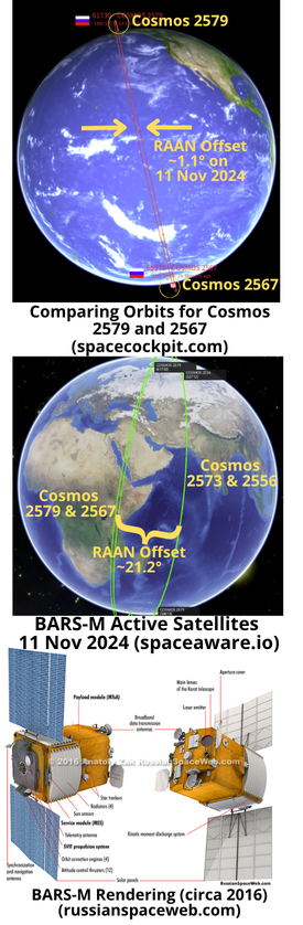
31 Oct: Russia launched a Soyuz-2-1a rocket from Plesetsk and successfully delivered Cosmos 2579 (61730) into its planned orbit. Cosmos 2579 is the BARS-M no. 6 spacecraft and is nearly co-planar with Cosmos 2567/Bars-M no. 4 (55978). Bars-M satellites are believed to capable of collecting high-resolution images with a ground resolution of ~1 meter. Launch Video.
With it’s 11-12 November maneuver, TJS-3 is now operating 32.6km above GEO and heading westward at a rate of 0.408° per day. As of 18 Nov 2024, TJS-3 was at 171.5°E longitude and is now West of TJS-10 which is at 173.8°E. TJS-10 has not made any maneuvers and is currently orbiting 1km above the GEO belt and heading west at a rate of 0.02° per day. Before TJS-3’s maneuver the 2 satellites were consistently <50km apart. After only ~7days that distance grew to 800+km.
– Cosmos 2579 is currently in a sun-synchronous orbit of 503x494km with an inclination of 97.6°.
– On 7 Nov Cosmos 2579 circularized its orbit and increased its perigee from 338km to 497km.
– As of 11 Nov Cosmos 2579 has a RAAN off-set with Cosmos 2567 of ~1.1°. I expect the RAAN offset to diminish over time, RAAN offset for Cosmos 2573 and 2556 is only 0.092°.
-While it is nearly co-planar with Cosmos 2567, Cosmos 2579 is currently operating at a slightly higher altitude. Cosmos 2579 SMA = 501.8km and Cosmos 2567 = 487.5km.
– There are now likely 4 operational BARS-M satellites on orbit, Cosmos 2579, Cosmos 2556 (launched 19 May 2022), Cosmos 2573 (launched 21 Dec 2023) and Cosmos 2567 (launched 23 Mar 2023). The first two BARS-M satellites, Cosmos 2503 and 2515 have not maneuvered in over 2 years.
– It appears that Russia is pairing up its BARS-M satellites as Cosmos 2556 and Cosmos 2573 are also co-planar (identical Inclination and RAAN values). The distance between Cosmos 2556 and 2573 is ~10,700km, and the separation between Cosmos 2567 & 2579 is ~13,300kms.
– Bars-M is one of several series of reconnaissance satellites Russia introduced in recent years, in attempts to fill the gap left by the retirement of its obsolete film-return Kometa and Kobal’t-M satellites. Other imaging satellites included the now-ended Persona series, and the smaller EMKA.
– Per Russian Space Web: “Originally designed to support cartography, the first Bars-M launched in 2015. The spacecraft’s main instrument, inside the MTsA payload module, consists of a dual telescope called OEK (Optical Electronic Complex) Karat. The triple-lens instrument was developed at the LOMO company in St Petersburg, which also built the main Persona reconnaissance satellite’s imaging system.”
– More Russianspaceweb.com: “The Ministry of Defense said that the spacecraft…had been taken under control by ground assets of the Russian Air and Space Forces, VKS.”
– Russia is likely struggling to meet the demand for high resolution imagery. Reporting indicates Russia is purchasing commercial imagery from China and other nations. BARS-M satellites are controlled by the Russian military which should improve tasking/collection/reporting responsiveness.
24 Oct: Michael P. Gleason from Aerospace Corporation’s Center for Space Policy and Strategy released a report describing lessons from the Ukraine-Russia conflict for US Department of Defense and the US Space Force. My main takeaway from the article was “Ukraine has demonstrated that what matters is not only what satellite data or services are available but also how fast they are delivered to the warfighter and how well equipped the warfighters are with proper user equipment and training for integrating and using data from space.” More excerpts below, read full report (9 pages) here.
– In early-2022 most national security experts would have predicted that Russia would gain significant advantage from its outer space capabilities in the event of an intensified conflict between the two (Russia & Ukraine) nations.
– Ukraine had neither a space program nor any national satellites…(but were able to) successfully leverage commercial space services, including imagery, radar, and communications, to enable
communications among their forces and to target Russian forces.
– Ukraine’s innovative use of data and networks to provide actionable information to fielded forces has had a powerful effect on the battlefield…ground systems and data networks have proven vital to Ukrainian forces’ ability to integrate the data from space into their operations and weapon systems. Effective data integration has strengthened Ukraine’s defense against numerically superior Russian forces.
– Russia has attacked and continues to threaten commercial space ground systems and data networks in this war, suggesting Russia knows how critical these capabilities have been for Ukraine. This highlights the vulnerability of ground systems and data networks. Russia’s attacks have consisted of temporary, reversible attacks against satellites or cyberattacks against ground infrastructure and not destructive attacks against the satellites themselves.
– Commercial electro-optical imagery and synthetic aperture radar companies, which can detect movements at night and through clouds, have helped Ukraine’s military forces target Russian assets and carry out battle damage assessments.
– Commercial satellite communications have also been fundamental to Ukraine’s defense. The commercial companies that have provided information to Ukraine include Viasat, OneWeb, SES, Iridium, Inmarsat, Eutelsat, Avanti, and, most prominently, Starlink.
– A key reason Russia has not been able to exploit its advantage in indigenous space capabilities is that Russian forces have not sufficiently integrated data from their space capabilities at the operational and tactical levels…(Russia suffers from) inadequate doctrine, strategy, training, material investment, and a lack of priority on “getting space support to the warfighter.”
-Ukraine has demonstrated that what matters is not only what satellite data or services are provided, but also how they are delivered to the warfighter…The networked, distributed approach to using and sharing information from space pursued by Ukraine and its allies has demonstrated the asymmetric advantages of this approach compared to the centralized, hierarchical structure used by Russia. The timeline for transferring data from space to warfighters has dropped from days to hours or, in some circumstances, to fewer than 10 minutes.
– The “Uber for artillery” application, GIS Arta, allows units collecting information on potential targets, including from satellites, to share that information directly with units that could fire on the targets. This application pairs sensors with shooters in a decentralized network instead of having to funnel specific information up and back down through centralized command nodes. As another example, Palantir software can draw imagery from a total of 306 commercial satellites. Soldiers in battle can use handheld tablets to request more satellite coverage if they need it.
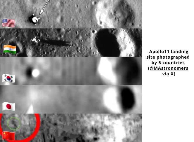
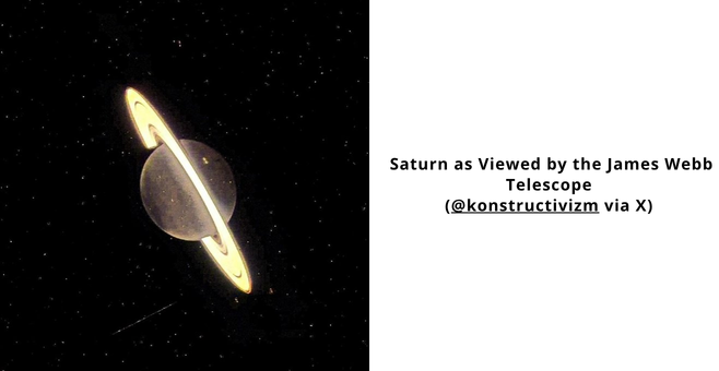
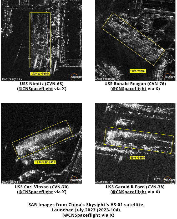
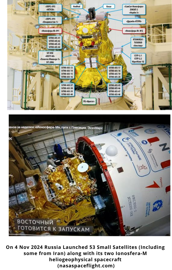
Pics o' the week!