Analysis of Developments in the Space Domain
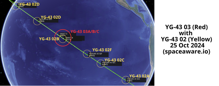
22 Oct: China launched a Long March-2C (LM-2C) with the third set of Yaogan-43 satellites (YG-43 03) from Xichang. The launch carried 3 satellites to a 500km/35° orbit. The 3 YG-43 03 satellites (61617-61619) are co-planar (matching inclination and RAAN) with the 6 YG-43 02 (60945-60950) satellites China launched on 3 Sep 2024. According to official sources, the satellites entered the preset orbit and will be “mainly used for carrying out tests on new technologies of low-orbit constellations”. Launch Video.
– The two previous YG-43 launches both used the larger LM-4B launch vehicle. In order to use the LM-2C for a multi-satellite launch China used an extended central load-bearing deployment platform, allowing the 3 YG-43 03 satellites to be side-mounted and improve the payload fairing’s space utilization.
– The LM-2C is a 2 stage rocket capable of placing ~4,000kg into Low Earth Orbit (LEO). In contrast the LM-4B is a 3 stage rocket capable of delivering ~4,200kg to LEO.
– With the 3 YG-43 03 satellites joining the 6 YG-43 02 in the same orbit (co-planar and equal SMA) there are now 9 total YG-43 satellites (60458-60466) in this particular plane. (see graphic below)
-The YG-43 02/03 satellites are also co-planar with YG-35 03, YG-36 04 and YG-39 02 satellites.
– I will continue to monitor the YG-43 03 satellites to determine if they are integrated into the YG-43 02 “formation.” China launched YG-43 03 into the middle of the YG-43 02 train. As of 25 Oct 2024 none of the YG-43 03 satellites has maneuvered.
– It will be interesting to compare YG-43 01 satellite spacing with the YG-43 02/03. More to follow!

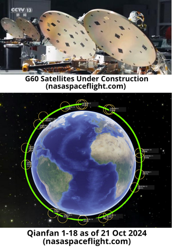
15 Oct: China launched a Long March-6A launch vehicle (LM-6A) with the second group of 18 Qianfan (SpaceSail Polar Orbit) satellites from Taiyuan. According to official sources, the 18 satellites constitute the second batch of the first generation of the SpaceSail Constellation, developed by Shanghai SpaceSail Technologies (SSST) Co., Ltd. to “provide global users with low-latency, high-speed and ultra-reliable satellite broadband internet services” Thankfully there were no reports of orbital debris resulting from the LM-6A upper stage. Launch Video.
– As of 26 October none of the satellites had been cataloged (2024-185).
– From Andrew Jones Article: “The Long March 6A upper stage deployed the flat panel Qianfan (or “Thousand Sails”) Polar Orbit-02 group of 18 satellites into polar orbit for Shanghai Spacecom Satellite Technology (SSST). The project is sometimes referred to as G60 Starlink.
– SSST plans for the constellation’s first stage to consist of 1,296 satellites. 648 of these are to be launched by the end of 2025 to provide regional network coverage. The completed network will consist of more than 14,000 low Earth orbit broadband multimedia satellites.”
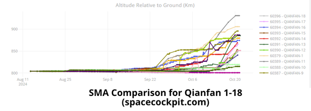
-Checking up on the first 18 Qianfan satellites:
16 Oct: China launched a Long March-4C (LM-4C) with Gaofen-12 05 (61571) synthetic aperture radar (SAR) imaging satellite from Jiuquan. According to official sources, Gaofen-12 05 entered the planned orbit successfully and “will be used in a variety of fields including land surveys, urban planning, road network design, crop yield estimation and disaster relief”. Launch Video.
– GF-12 05 is in a 626 x 612km sun-synchronous orbit (SSO) with an inclination of 97.9°.
– As the name suggests, this is China’s 5th Gaofen-12 launch. All used the LM-4C launch vehicle and all 4 of the 5 launches have been from Jiuquan. The only exception was GF-12 01 (44819) which launched from Taiyuan in 2019.
-GF-12 05 appears to be near its operational orbit as its perigee and apogee values are within 5km of the other GF-12 satellites. Overall SMA is within 2km of GF-12 01-04 (628.6km to 626.5km avg).
-The Gaofen-12 satellites are part of the civilian China High-resolution Earth Observation System (CHEOS).
– Background on the CHEOS program: As noted in the Eleventh Five-Year Plan , CHEOS aims to build an Earth observation system with high spatial, temporal and spectral resolution in an all around way, and actively meet the major national strategic needs of China’s national defense, natural resource survey, disaster response and prevention. CHEOS has promoted the continuous maturity of high-resolution Earth observation technology in China, and the wide application of high-resolution images.
– According to Li Deren, a top Chinese remote sensing scientist, China has invested ¥50 billion in the CHEOS (Gaofen) program, and the resolutions for civil and military use have reached 0.3m and 0.1m, respectively. Interestingly, Li presented a slide that explicitly mentioned the Gaofen-8-14 Satellites were “military satellites.”
-From Gunther’s Space Page: “GF 12 has been reported to be equipped with a high-resolution Earth observation system. It uses a microwave remote sensing system with ground resolution up to the sub-meter level, to be mainly used in land census, urban planning, land rights, road network design, crop estimation and disaster prevention and mitigation and other fields. Possibly it is a civilian version of the Yaogan 29 type satellite.”

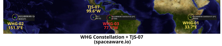
21 Oct: After spending ~11 days in Geostationary Transfer Orbit (GTO), China conducted a circularization burn and placed its “High Orbit Internet Services Satellite,” WHG-03 (61503) into GEO stationary orbit. The satellite is now orbiting at 77.1° WEST longitude with a 0° inclination. WHG-03 joins TJS-7 (49115) as China’s only 2 active GEO satellites operating over the Western Hemisphere.
– China has released no details regarding the mission and capabilities for the WHG satellite series.
– A November 2023 Xinhua report noted the China Aerospace Science and Technology (CAST) Corporation had completed the first high-orbit satellite Internet. The report noted that the purpose of the satellites was to completely cover the entire territory of China and key areas along the “Belt and Road” countries.
– WHG-03 is located 22.5° east of TJS-7 which has been at 99.6°W after it relocated from 146.5°E.
-As a refresher: In late Oct 2022, TJS-7 decreased its Semi-Major Axis (SMA) 332.3km and drifted East. TJS-7 maintained its drift for most of Nov 2022, rejoining the GEO belt around 26 Nov 2022.
-TJS-7’s position at 99.6° W longitude which is centered on the continental US. The location seems to support either the SIGINT or missile warning missions suspected of the other TJS satellites.
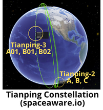
22 Oct: China launched a Long March-6 with three Tianping-3 satellites (61614-61616) from Taiyuan. The satellites are Tianping-3 A(01), B(01), and B(02). According to official sources, Tianping-3 A(01) is “mainly used for ground radar equipment calibration and RCS measurement, provides support for ground optical equipment imaging experiments and low-orbit space environment detection experiments, and provides services for atmospheric space environment measurements and orbit prediction model corrections”. Launch Video.
– The Tianping-3 A01, B01 and B02 satellites join 4 other Tianping satellites currently in orbit. The newest Tianping satellites are in an ~566 x 555km with 97.6° inclination.
– China launched the first Tianping satellites, Tianping-1A and 1B (43712 & 43714) in 2018. Tianping-1A re-entered on ~7 Oct 2024. Tianping-1B appears to be heading toward a similar fate and is in a naturally decaying orbit.
– China launched the Tianping-2A, 2B & 2C satellites on 30 Mar 2022. All appear to be maintaining their orbits.
-Per Andrew Jones: “Tianping-3 satellites can be used as benchmarks
to compare and validate the measurements of ground-based radars, offering highly accurate measurements of their RCS. The satellites may have corner reflectors or transponders on board to provide a strong and well-characterized signal to ground-based radars. This signal helps in calibrating the radar’s performance, such as its power levels, antenna alignment, and other critical parameters.”
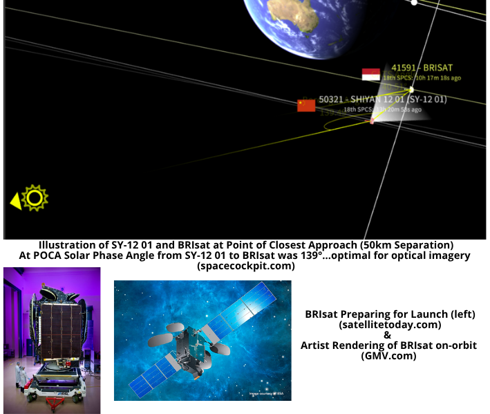
25 Oct: One of China’s suspected inspection satellites, Shiyan- 12 01 (SH-12 01/50321) came within 50km of Indonesia’s BRISAT (41591). At the point of closest approach the lighting conditions were optimal (solar phase angle (SPA) >130°) for SY-12 01 to image BRIsat. SPA remained >130°optimal for ~15 minutes when the satellites were ~85km apart.
SY-12 01 last maneuvered on ~11 Sep 2024 when it increased its altitude to initiate a Westward drift. It does not appear that SY-12 01 made any maneuvers in preparation for its fly-by of BRIsat. SY-12 01 remains 45.4km above the GEO belt and is drifting 0.6° per day.
BRIsat has been in GEO since its launch in 2016 and is located at 150.5°E longitude. Per Gunther’s Space Page: BRIsat has “45 transponders (9 Ku-band, 36 C-band), which cover areas in Indonesia, ASEAN, North east of Asia, some Pacific area and West Australia. From its orbital position at 150.5° East, it delivers highly reliable communications services to BRI’s 11,000 bank branches across the Indonesian archipelago.”