issue 104 | 1 sep 2024
The integrity flash
Analysis of Developments in the Space Domain
in this issue
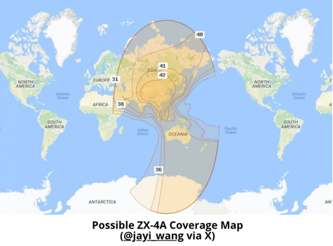
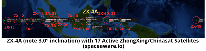
22 Aug: China launched a Long March-7A with the ZhongXing-4A (60606) communications satellite (ChinaSat-4A) from Wenchang. According to official sources, ZhongXing-4A entered the planned orbit successfully and will “provide voice, data, radio and television transmission services”. This follows the ZhongXing-3A launch which occurred on
29 June 2024. ZhongXing-4A Launch Video.
– China released very limited information regarding ZX-4A. The satellite joins 17 other ZhongXing (Shentong or Chinasat) satellites in GEO.
– ZX-4A is currently located over the equator at 117.94°E. Initial observations show ZX-4A with a 3.0° inclination. This is by far the most inclined of any of the Zhonxing satellites, the closest competitor being ZX-6B (31800) at 0.7° inclination.
– China is in the process of replacing its older satellites. In Nov 2023 it launched ZX-6E to augment/replace ZX-6B which was launched in 2007.
– China has not mentioned ZX-4A previously. The next expected launch was ZX-9C to replace ZX-9 sometime in 2025.
– Zhongxing/Chinasat satellites have a life expectancy of 15 years.

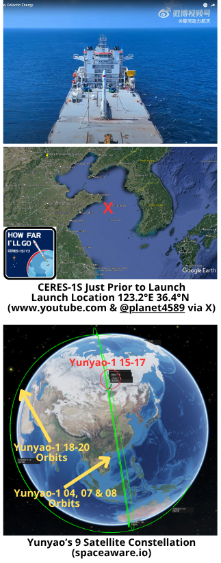
29 Aug: China’s Galactic Energy conducted its third sea launch with the Ceres-1S Y3 rocket and delivered 6 satellites to Low Earth Orbit (LEO). According to official sources, the six satellites are: 1-3) Yunyao-1 15-17; 4) Jitianxing A-03 (also known as Suzhou-1); 5) SuXing-1 01; and 6) Tianfu Gaofen-2 (also known as Huaxiangyuan-1). All are in the intended 535 km Sun-synchronous orbits (SSO). Launch Video.
– The launch was the 15th flight mission for the CERES-1 rocket series. The launch brings the total number of on orbit Yunyao satellites to 9.
-The orbit for the Yunyao-1 15-17 satellites is a close match (but not co-planar) to that of the Yunyao-1 04, 07 and 08 satellites China launched in Aug 2022 using a LM-6.
– From Andrew Jones Space News Article:
- The 3 Yunyao-1 spacecraft are equipped with GNSS occultation (GNSS-RO) and infrared imaging payloads, intended to provide meteorological data for commercial firm Yunyao Yuhang.
- Jitian-A03 is equipped with a hyperspectral remote sensing payload for high-resolution optical remote sensing technology verification.
- Suxing-1 (01) carries an optical payload. The satellite will be used by Northwestern Polytechnical University (NPU) Taicang Yangtze River Delta Research Institute, according to Beijing News.
- Tianfu Gaofen-2 is another hyperspectral satellite, and will be operated by Xiamen Tianwei Technology Co., Ltd., which will use the data for applications in fields including environmental monitoring, resource management and urban planning.

31 Aug: As reported in the 18 Aug edition of the Integrity Flash, China used a LM-4B to launch 9 Yaogan-43 01 satellites on 16 Aug 2024. All 9 satellites were sent to a very familiar orbit of ~500km altitude and inclination of 35°. After 15 days in orbit the group remains co-planar and only one satellite appears to have maneuvered.
– The 9 satellites are cataloged sequentially…2024-148A-H and 148J (60458-60466).
– On 31 Aug 2024 the satellites were arrayed in the following order (from Lead to Trail8): Lead: 148J / Trail1: 148D / Trail2: 148H / Trail3: 148E / Trail4: 148G / Trail5: 148F / Trail6: 148D / Trail7: 148C and Trail8: 148A
– Examining the Celestrak orbit history graphs it appears that only one of the 9 satellites, 2024-148C had made any significant maneuvers, raising its SMA ~2.4km. The remaining 8 satellites appear to be in naturally decaying orbits. 148C’s altitude is now 3-5km than the other YG-43 satellites. As a result (10:1 rule again) it is falling back in the train.
-The largest time difference between objects between 19 Aug and 28 Aug was 148A falling 1 min 36 sec further behind 148B at the back of the train.
– It is far to early to draw any conclusions regarding the possible formation of the YG-43 01 satellites.
-Here is what we do know:
- There are 9 co-planar YG-43 01 satellites.
- YG-43 01 satellites are at the same altitude and inclination as the YG-35/36/39/42 satellites.
- YG-43 01 is NOT co-planar with any of the YG-35/36/39/42 satellites.
- There are 15 YG-35/36/39/42 triplets in 5 orbital planes. There are 3 sets of triplets (9 satellites) in each plane.
- Official sources noted Minospace and IAMCAS contributed to YG-43 01 and both specialize in small, networked satellites.
YG-43 01 could be a miniaturized version of the YG-35/36/39/42 satellites. If so, China has deployed a full orbital plane of 9 satellites with one LM-4B. By comparison China used 3 LM-2Ds to deploy a single plane of the YG-35/36/39/42 satellites. If the YG-43 01 satellites maneuver into 3 distinct formations of 3 satellites each, this would be further evidence that they share mission and capabilities with the YG-35/36/39/42 satellites. Now if we just knew more about the YG-35/36/39/42s…

15 Sep: Shiyan-12 01 (SY-12 01/50321)), which has been rumored to be the Chinese version of GSSAP, raised its orbit on 10 Sep as it approached its historic turnaround point of 178.9°E. On 9 Sep the satellite was at 176.0°E and drifting further east at a rate of 0.6° per day. From 10-11 Sep the satellite increase its altitude a total of 91.1kms and is now 45.5kms above GEO initiating a westward drift of 0.6° per day. During its wanderings, SY-12 01 passed the TJS-3 and TJS 10 satellites twice (5 Sep when it was heading east and then again on 15 Sep as it moved west.) Solar phase angles for imaging TJS-3 and 10 were marginal on 5 Sep but excellent on 15 Sep.
– YG-35 05 (as of 28 Aug):
- Lead is ~5min 30sec ahead of Trail1. Trail1 is ~4min 00sec ahead of Trail2.
- On 25 July 2024 the gap between Trail1 and Trail2 was 36min 41sec.
- China raised Trail2 (53760) altitude 2km from 493.4 to 495.5km between 22-29 Aug 2024.
- RAAN for Lead and Trail1 = 143.1°. RAAN for Trail2 = 139.5°. RAAN difference = 3.6°
– YG-36 03 (as of 28 Aug):
- Lead is ~6min 19sec ahead of Trail1. Trail1 is ~6min 32sec ahead of Trail2.
- On 25 July 2024 the gap between Trail1 and Trail2 was 36min 39sec.
- China raised Trail2 (54376) altitude 2.6km from 492.2 to 494.8km between 6-16 Aug 2024.
- RAAN for Lead and Trail1 = 143.65°. RAAN for Trail2 = 140.06°. RAAN difference = 3.6°
I found it interesting that the RAAN differences between the two re-formed formations were identical and decided to take a look at a few other formations.
– YG-36 05, YG-39 01, YG-39 02, YG-39 03, YG-39 04 & YG-39 05 remain co-planar with negligible RAAN differential.
– YG-35 02 + YG-42 01 (59395): RAAN for Lead and Trail1 = 287.65°. RAAN for Trail2 = 286.80°. RAAN difference = 0.85°
– YG-36 01 + YG-42 02 (59557): RAAN for Lead & Trail1 = 70.99°. RAAN for Trail2 = 70.39°. RAAN difference = 0.6°
– YG-36 02: RAAN for Lead & Trail1 = 287.1°. RAAN for Trail2 = 280.52°. RAAN difference = 6.58°
China appears to have taken the past 8 months to experiment with varying Trail2 RAAN offsets. We will have more evidence next month with YG-35 04 & YG-36 04 returning to formation.

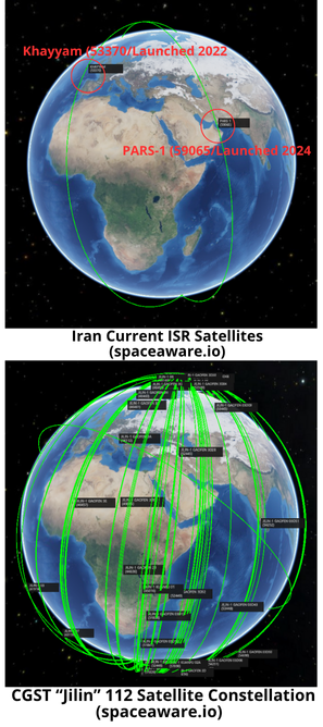
16 Aug: Joby Warrick and Souad Mekhennet of the Washington Post published an article discussing the increasing collaboration between Iran and China in regards to the development of ISR satellites. Specifically, the article notes that Iran is pursuing partnerships with 2 Chinese commercial companies to expand its space-based intelligence, surveillance and reconnaissance (ISR) capabilities. The two companies (Chang Guang Satellite Technology Co & MinoSpace Technology Co) offer satellites with up to 30cm resolution, more than twice as capable as the current 1m resolution for Iran’s current ISR satellites. Excerpts Below.
– Iran is pursuing partnerships with two Chinese satellite companies…to expand its capability for remote surveillance/intelligence gathering, potentially including high-resolution images of military targets in Israel and across the Middle East.
– Any deal that emerges could allow Iran to dramatically improve its ability to spy on U.S. and Israeli military installations as well as those of Arab rivals in the Persian Gulf.
– The two companies offer a line of satellites with optical equipment that is at least twice as sensitive as the most advanced satellites operated by Iran.
– Iran has previously sought help from Russia in developing a network of Iranian-controlled surveillance satellites.
– A deal with China could supply Iran with enhanced targeting capability for its arsenal of ballistic missiles as well as early warning systems to detect impending attacks.
– Chang Guang Satellite Technology Co…makes small, low-cost “cubesat” satellites with optical equipment still capable of producing images with a resolution as fine as .3m. They currently have 112 satellites on orbit which includes a mixture of optical and SAR imagers.
– Chang Guang was embroiled in controversy last year after reports that it supplied satellite services and imagery to Russia’s Wagner mercenary group. The reports linked the company to a $30 million agreement signed by Wagner officials in November 2022.
– MinoSpace Technology Co., which makes the Taijing-series remote sensing satellites. They currently have 10 satellites on orbit (8 optical and 2 SAR imagers).
– Iran’s Khayyam satellite produces images with a resolution of about 1 meter.
– China is now Iran’s biggest customer for petroleum products, and trade between the two countries has flourished, climbing to $32 billion last year.
– China may believe it has a legitimate civilian cover for assisting Iran’s space program, since surveillance satellites have many nonmilitary uses, such as environmental monitoring and disaster response.
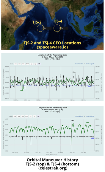
22 Aug: Based on insights provided by Exoanalytics, Aviation Week Senior Editor Guy Norris published an article discussing China’s growing expertise in satellite maneuver, particularly in Geostationary Orbit (GEO). China appears to be less concerned with fuel usage and willing to simply replace GEO satellites when they exhaust their fuel supply. Article excerpts below.
– Recent Chinese spacecraft maneuvers…show increasing capability in key areas of control for counter inspection, co-orbital anti-satellite weapons and other potential threats.
– U.S. space defense leaders continue to warn of the rapid growth of China’s military assets in geostationary Earth orbit (GEO). “They’re getting better. They’re getting more comfortable,” said Rhett Butler, vice president of ExoAnalytic’s National Security Space Sector. Describing China as “the most active adversary we have today,” he added that “they are actively practicing counterspace techniques and showing that technology.”
– Anomalous acceleration by TJS-2 (41911), a Chinese signals intelligence (SIGINT) and early warning satellite, indicates growing strength in depth and a willingness to practice rapid maneuvers regardless of excessive fuel usage.
-“We noticed it would do some huge maneuvers at different points in time, maneuvers that were kind of unexpected,” Butler said. ExoAnalytic’s network tracked TJS-2 maneuvering at 44 m/sec, compared with more standard repositioning maneuver speeds of around 0.5-1 m/s.
– The implication is that “fuel is not a problem,” Butler said. In practice, this means China’s policy is based on frequent replacement of on-orbit
assets rather than the U.S. military’s preferred concept
of life extension.
– This was demonstrated earlier this year when a U.S. space surveillance satellite was tasked with inspecting TJS-4, a suspected SIGINT satellite launched in 2019. The US satellite’s pass was designed to give it a Sun advantage and a long dwell time right over TJS-4, but “unfortunately, it didn’t go down that way,” Butler said. Instead, the Chinese spacecraft used similar maneuvers to those seen being practiced earlier with other vehicles. “All of a sudden, we’re not in phase anymore. We don’t have that beautiful Sun angle pass. It will actually be shorter now, right over the top, and the Sun will be at their back.”
– SJ-23, a Chinese satellite launched in January 2023…is believed to be capable of rendezvous proximity operations, including close inspection and towing of other satellites with a grappling arm. Following the second injection burn, it soon became obvious that the intended orbital slot was in a location already occupied by USA 270…Observers watched as SJ23 took aim at USA 270. “It was coming in hard,” Butler said. “And it looked like it was going to hit the same spot at the same time, [but] then they did a last burn and they threw the brakes on.”
26 Aug: The China Aerospace Studies Institute (CASI) published a study by Dr. Randy Liefer examining several Chinese academic papers on space-based Space Situational Awareness (SSA). Dr Liefer found that Chinese academic researchers are studying all relevant science issues and most of the available Chinese academic literature deals with optical sensors. Most interestingly, there are a few recommendations for deployment of a space-based SSA dedicated constellation. Excerpts below.
– National University of Defense Technology (NUDT) authors have studied various viewing patterns to maximize the number of objects in the GEO belt that might be missed during a given period of time
– Research from NUDT and the Beijing Institute of Tracking and Telecommunications Technology makes a convincing argument for placing those observing satellites in equatorial LEO rather than Sun-synchronous LEO orbits. They propose equipping a single observing satellite with three sensors pointing in different directions.
– Researchers from NUDT correctly note that using satellites to surveille objects in LEO is very difficult due to the high orbital velocities in LEO.
– NUDT proposed several candidate constellations consisting of two or three satellites all in the same Sun-synchronous orbit but trailing each other by only a few degrees. They assess the relative performance of these constellations against multiple sets of target objects in highly inclined and Sun-synchronous orbits
– Nanjing University of Aeronautics and Astronautics claim that infrared sensors are used to surveille objects in LEO but the example they cite is the U.S. Space Based Infrared Satellite (SBIRS) constellation
– School of Geodesy and Geomatics at Wuhan University evaluated, via simulation, several proposed constellations of scanning satellites in multiple Sun-synchronous planes. They assess the theoretical ability of optical satellites in those planes to catalog very small debris in LEO orbits based on assumptions of size, distribution, lighting conditions, reflectivity, and line-of-sight visibility.
– Chinese Researchers are also exploring the use of Star Tracker information to augment SSA. Chinese Academy of Sciences modeled these “free” observations and showed how they could be used to determine the orbital characteristics of the objects they see. They promise future work that will validate this concept with actual star tracker data.

This essay will introduce the process of a “chaser” spacecraft (maybe a refueler servicing vehicle) goes through to arrive at the “target” spacecraft (the one who ordered the refueling). The terms chaser and target have been used by NASA way back as they planned and executed rendezvous, then loitered around the other spacecraft, that’s called proximity operations, and then they would dock. Some call this ZPO, zero prox ops. This process involves maneuvering the chaser and hopefully the target is cooperative and not maneuvering without telling you.
The chaser’s orbital elements provide information into how the rendezvous mission progressing If you are not aware of the target, following this trend will help resolve that. It’s the change and matching of the chaser’s elements to the target’s elements that give insight into how the process is moving along. In the end, if the chaser is to dock with the target, then the orbital elements must match. There are three phases to completing a RPO and then ZPO. While the chaser’s maneuvers may not always follow the expected flow of these phases, they provide a framework to follow along. Here below is a table that summarizes the 3 phases. Give it a review and study before reading on, it will be helpful.

Let’s look at each phase and go a little deeper to give you insight into what’s going on.
Orbit Plane Matching: Plane matching usually occurs early in planning and executing a mission. The launch vehicle usually does it all, you launch right into the orbit plane of the target (see Russia’s Kosmos 2558 and 2576). But there can be errors in that insertion and thus orbit plane matching maneuvers are needed. Below is a simple illustration (all my drawings are simple😁) that shows the red and blue orbits have different inclinations and RAANs. So, the task at hand to match orbit planes would be to execute a Delta V where that star is and get the orbit planes matched to have same inclination and RAAN. A really important step to ensure when you get close for proximity operations you are not zig zagging back and forth.

The chaser can do a series of small orbit plane adjust maneuvers to incrementally get the orbit planes aligned. As you all remember from the Orbital Element Series of articles I wrote, the orbit plane is characterized by the inclination and RAAN. The amount of Delta-V to align inclination only gives us some basic rules of thumb. In GEO, 53 m/s of Delta-V is needed to change or correct 1 degrees of inclination, for LEO it’s about 115 m/s. But remember, you got to also get the RAAN lined up. That can be costly in propellant. Here’s an example: You launched into a 97.4 degrees incline LEO orbit. Nailed the inclination. But, the RAAN is not aligned, it’s off by 1.5 degrees. How much Delta-V do you think is needed to fix that? Hummmm? Well, its 197.5 m/s, wow! Now, get ready for some learning, what if the inclination was 28 degrees. Is there a difference in what’s needed to fix the 1.5-degree error in RAAN? Yup, it’s only 97 m/s. Still, a lot. So, orbit plane matching usually is the launch vehicles chore, but if you need to tweak things to get the orbit planes aligned, that can cost you fuel (and time making PowerPoints to explain what’s going on…LOL).
- Orbit Shaping & Alignment: Normally mission planners like to have the long axis of the orbits matched, this is called the line of apsides. It enables efficient maneuvering. This can be a very subtle stage, usually the orbits are so near circular this phase may not occur. Orbit shaping is reflected in the eccentricity and argument of perigee matching. Hopefully the launch vehicle did its job getting things properly inserted into orbit. Of course, if the target starts playing games and maneuvering, then this problem gets tougher. The illustration on the next page shows that the red dashed orbit and the blue orbit do not have their lines of apsides lined up. Some planners would want to execute a maneuver to get them aligned to support more efficient maneuvering.

Orbit Phasing: This is my favorite phase. This is where you get to close in on the target and hang out with them or better yet, dock and refuel them. This phase is usually seen as where the chaser orbit is being adjusted and we see changes in its orbit’s apogee and perigee. They are fiddling with the semi-major axis and getting the approach going, perhaps slowing down the relative closer rate. As semi-major axis getting close to a match, chances are the true anomaly is also closing in. Match them up and you can reach out and shake hands or get set for the dock and refueling. Here’s a cool rule of thumb I think you’ll enjoy knowing and sort of relates to phasing. For LEO Earth orbits, there is a 10:1 rule, my friend James Oberg at NASA/JSC came up with it. Here’s what it means. If you are 1 Km below your target orbit and you are plane matched and circularized, then you will advance 10Km forward each orbit period. Thus 10:1. So, let’s say you are 5 Km below and 150 Km behind. Let’s say your orbit periods are really close and 90 minutes. OK, so when will you be right underneath the target? Well, use the 10:1 rule. Each orbit you scoot ahead relative to the target 50 Km (5 Km times 10). So, we are 150 Km behind, and guess what? In 3 orbit or 4.5 hours we can look “up” and see the target. Pretty cool, the 1- to 1 rule of thumb by James Oberg. Yay for him!
Well, there you have it. The 3 phases of RPO and some details as to what’s going on. You may ask, how does Jack know this stuff? Well, two folks play a BIG role in helping me understand and get all enthusiastic about RPO. Dr Chirold Epp helped me in the early 1980’s. While at Johnson Space Center I’d meet with Dr Epp and he’d tell me all the cool things Shuttle would be doing with regard to RPO. He helped me understand the math and art to all this. Then Mr. A. Clark Keith III came along in 1989 as my Aerospace Corporation advisor for the famous TAOS space mission that flew 1994-2000. I got to know Clark and one of his finest hours (or years) was the XSS-11 RPO test
mission that flew 2005-2007. Clark was the Flight Director and he wrote up notes that comprised a “how to” handbook for RPO. Just before his battle with cancer took him from us in 2013, Clark wrote up his notes and gave them to his colleague Jim Baker to publish. I met with Clark just before he passed and he said “Jack’s I’m writing everything down, make sure you read and live it.” Clark’s experience, insight, and ability to explain things was awesome and helped all of us know the ways to achieve RPO. He is the Father of Military RPO. He played a huge role in planning the ANGELS mission and many more space test missions. I miss Clark and thank him. DO YOU HAVE A MENTOR HELPING YOU UNDERSTAND YOUR AREA OF RESPONSIBILITY? I BET YOU DO.
Here’s a photo of Clark and I in 2011 at the USAF Academy FalconSAT Operations Center. He loved coming to meet with the cadet’s and talk spaceflight!

Pics o’ the Fortnight!