issue 105 | 15 sep 2024
The integrity flash
Analysis of Developments in the Space Domain
in this issue
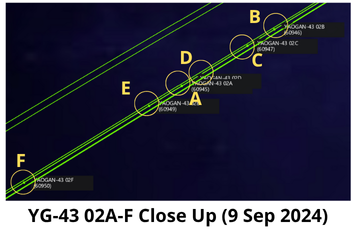
3 Sep: China launched a Long March-4B with 6 Yaogan-43 Group 2 (YG-43 02) remote sensing satellites from the Xichang. According to official sources, the satellites entered the preset orbit and will be “mainly used for carrying out tests on new technologies of low-orbit constellations”. This was the second YG-43 launch in less than 3 weeks as China launched 9 YG-43 01 satellites on 16 Aug 2024 (more on them later). The YG-43 02 satellites (60945-60950) are orbiting at 500km altitude with 35° inclination. YG-43 02 is also nearly co-planar with the three sets of YG-35 03, YG-36 04 and YG-39 02 triplets. Launch Video.
– As of 9 Sep 2024 none of the satellites has maneuvered. This is similar to the initial batch of YG-43 01 satellites which began to maneuver 1-2 weeks after launch.
– As with the YG-43 01 launch, the LM-4B carrying YG-43 02 used a 4.2m fairing (typical is 3.7m.)
– Per Andrew Jones: “The Yaogan-43 (02) satellites were developed by CASC’s Shanghai Academy of Spaceflight Technology (SAST). Official social media posts suggest that GalaxySpace, a commercial satellite manufacturer and operator, and HITSAT, under the Harbin Institute of Technology, may have been involved in the mission. IAMCAS under the Chinese Academy of Sciences, and MinoSpace, a commercial spacecraft maker, were believed to be involved in the prior mission (YG-43 01).”
– China launched the 6 YG-43 02 satellites into a nearly co-planar orbit with 8 other Yaogan satellites with very similar altitude, inclination and RAAN (orbit twist).
- YG-35 03 consists of only 2 satellites (B & C) as it’s original Trail2 satellite (A) last maneuvered in January 2024 and is no longer part of the trio.
- YG-36 04 consists of all three satellites. Its Trail2 satellite (B) will likely rejoin the Lead and Trail1 satellites (C & A) in formation later this month.
- YG-39 02 consists of all three satellites and appears to have been operating in nominal condition maintaining its formation since its launch on 17 Sep 2023.
– China launched the 9 YG-43 01 satellites into a unique plane. More details to follow in the coming weeks.

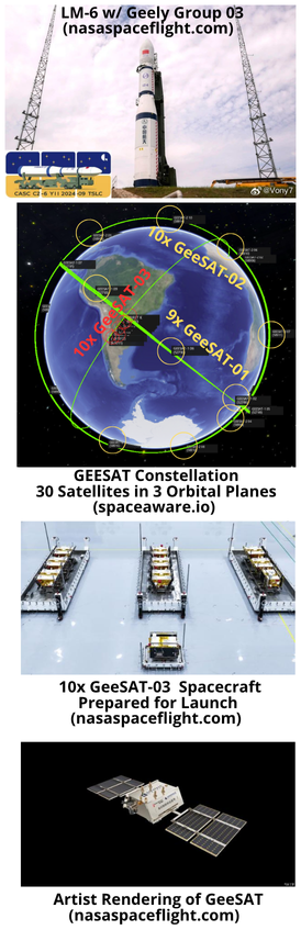
5 Sep: China launched a Long March-6 with 10 Geely Group 03 satellites (2024-159) from the Taiyuan Satellite Launch Center. According to official sources, the 30 Geely satellites launched so far distributed across three orbital planes, enable “24-hour coverage of 90% of the globe, officially launching satellite communication services for global users”. Launch Video.
– With this launch there are now 30 GeeSATs in orbit. All are inclined 50.0° and operating between 550-600km.
– Each launch populated a single orbital plane.
- GeeSAT-1 01-09 launched on a LM-2C from Xichang in June 2022 (2022-058).
- GeeSAT-2 01-10 also launched on a LM-2C from Xichang in February 2024 (2024-023).
- Both GeeSAT-1 and -2 satellites appear to have spread out evenly in their orbital planes.
– Per post from Blaine Curcio, “This launch was characterized by Shanghai Academy of Spaceflight Technology as the highest-launch mass ever for a LM-6 rocket.” Estimates of satellite mass vary from 100-130kg per satellite. The designed capacity of LM-6 can be up to 1000kg for 700km sun synchronous orbit.
– Unlike recent launches of the LM-6A, there have been no reports of debris generation from the upper stage of this LM-6 launch. The LM-6A is a larger variant and uses 4 additional solid rocket boosters.
– Per Gunter’s Space Page: “The GeeSAT network is a private navigation augmentation system satellite constellation developed by Geespace, a subsidiary of the Zhejiang Geely Holding Group. These satellites will be providing centimeter-level positioning services to terminals on the ground, notably in automotive, marine or UAV applications. They will also provide cloud and data processing services to the aforementioned industries.”
– Previously, Geespace announced it’s final constellation would be made up or 72 satellites and be on-orbit by the end of 2025.

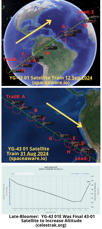
13 Sep: As reported in the 18 Aug edition of the Integrity Flash, China used a LM-4B to launch 9 Yaogan-43 01 satellites on 16 Aug 2024. All 9 satellites were sent to a very familiar orbit of ~500km altitude and inclination of 35°. After 28 days in orbit the group remains co-planar and all 9 satellites have increased their altitudes. The maneuvers were not uniform and occurred at different times and to different altitudes. The satellites are not in any identifiable formation. The separation between the Lead satellite and the final trailing satellite (Trail8) has increased from 2min 17sec on 19 Aug, to 7min 26sec on 28 Aug, to 28min 18sec on 11 Sep.
– The 9 satellites are cataloged sequentially…2024-148A-H and 148J (60458-60466).
– The satellite order (Lead to Trail8) has changed significantly in the past 2 weeks, only 1 of the 9 (148D) remains in the same relative position. On 12 Sep 2024 the satellites were arrayed in the following order: Lead: 148E / Trail1: 148D / Trail2: 148G / Trail3: 148J / Trail4: 148B / Trail5: 148A / Trail6: 148F / Trail7: 148H & Trail8: 148C.
– Maneuver Analysis
- All satellites have maneuvered in the past 7 days. The final satellite to increase its altitude was 43-01E (which is why it is now Lead). The first satellite to increase its altitude (43-01C) is now the Trail8 satellite.
- Altitude Range for 43-01 is 494.1 – 500.5kms. Eccentricity values for all satellites is between .0006 and .0007.
- 43-01A: 1st Maneuver 6 Sep / SMA up 7.1km
- 43-01B: 1st Maneuver 4 Sep / SMA up 5.1km
- 43-01C: 1st Maneuver 22 Aug / SMA up 4.4km
- 43-01D: 1st Maneuver 6 Sep / SMA up 4.4km
- 43-01E: 1st Maneuver 7 Sep / SMA up 4.1km
- 43-01F: 1st Maneuver 4 Sep / SMA up 7.2km
- 43-01G: 1st Maneuver 5 Sep / SMA up 5.2km
- 43-01H: 1st Maneuver 31 Aug / SMA up 6.7km
- 43-01J: 1st Maneuver 2 Sep / SMA up 6.3km
– It is still too early to draw any conclusions regarding the possible formation of the YG-43 01 satellites. All satellites have successfully raised their altitudes, however continued variance in altitudes will change relative positions within the group.
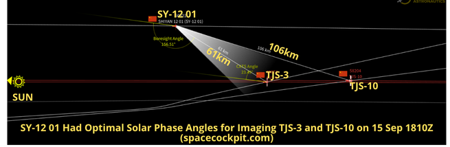
SY-12 01 Raises Orbit to Reverse Drift & Visits TJS-3 & 10
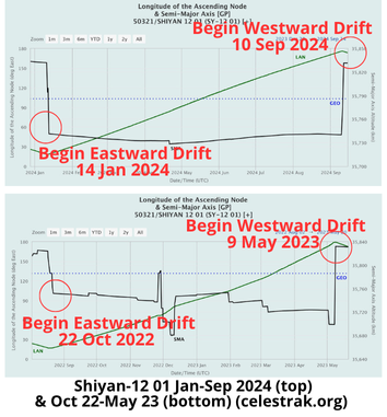
15 Sep: Shiyan-12 01 (SY-12 01/50321)), which has been rumored to be the Chinese version of GSSAP, raised its orbit on 10 Sep as it approached its historic turnaround point of 178.9°E. On 9 Sep the satellite was at 176.0°E and drifting further east at a rate of 0.6° per day. From 10-11 Sep the satellite increase its altitude a total of 91.1kms and is now 45.5kms above GEO initiating a westward drift of 0.6° per day. During its wanderings, SY-12 01 passed the TJS-3 and TJS 10 satellites twice (5 Sep when it was heading east and then again on 15 Sep as it moved west.) Solar phase angles for imaging TJS-3 and 10 were marginal on 5 Sep but excellent on 15 Sep.
– China launched SY-12 01 and 02 on 23 Dec 2021 on a LM-7A from Wenchang. There has been open source comparison with the US GSSAP mission.
– In 2022 there were some interesting interactions between USA270 (a GSSAP satellite) and both Sy-12 satellites (watch Video).
– SY-12 01 began it most recent eastward journey on 14 Jan 2024 when it decreased its altitude ~91km and transitioned from 46.1km above GEO to 44.7km below GEO. China conducted this maneuver when SY-12 01 was at 18.1°E.
– SY-12 01 maintained an eastward drift for 240 days until its maneuver on 10 Sep.
– This is similar to the 260 days SY-12 01 operated below GEO from 22 Aug 2022 – 9 May 2023.
– SY-12 01 conducted far fewer maneuvers during its current eastward drift than was observed during its transit in 2022-23 (see graphs).
-China has been operating its TJS-3 and TJS-10
experimental satellites in proximity with one another since TJS-10’s arrival in GEO on 9 Nov 2023. Currently the satellites maintain ~50-70km separation (TJS-3 @ 172.97°E/TJS-10 @ 172.89°E.)
– On 5 Sep 2024 at 07:31Z, SY-12 01’s orbit took it within 43km of TJS-3 and 79.1km of TJS-10. There was no apparent maneuvering from any of the satellites just prior to, or during this time. At this time the solar phase angle (SPA) was marginally favorable for SY-12 01 to image TJS-3 and unfavorable for imaging TJS-10.
– On 15 Sep at ~1810Z, SY-12 01 had a POCA with TJS-3 of ~61km and TJS-10 of ~106km. SPA for SY-12 01 to image both satellites was excellent. There were no apparent maneuvers from any of the satellites just prior to or during this time.
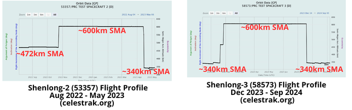
6 Sep: The Chinese spaceplane (Shenlong-3) landed at Lop Nur after spending 267 days in orbit. This was the third mission for the Shenlong spaceplane and was 9 days shorter than the second mission (276 days). China has announced minimal information regarding Shenlong-3’s mission, however all three flights have involved some form of Rendezvous and Proximity Operations (RPO) testing. During all three missions the Shenlong has released a small satellite and then proceeded to RPO with the object, possibly retrieving and then re-releasing it. During this flight it appears Shenlong released 7 objects, 6 soon after launch and “Object G” on 25 May 2024. Object G appears to have maneuvered and tested with Shenlong. Video.
– China launched Shenlong-3 on 14 Dec 2023 into an initial orbit of 332.9 x 347.9 km with a 49.99° inclination. In late Jan the spaceplane raised its orbit to 609x603km orbit with the inclination remaining unchanged. It remained at this altitude until 19 Jul 2024 when it decreased its SMA to ~340km.
-While the flight durations were similar, Shenlong-3’s flight profile differed from its predecessor.
- Shenlong-2’s initial orbit was 472km or more than 100kms greater than Shenlong-3.
- Shenlong-2 remained at its initial 472km SMA for 80 days before transitioning to its ~600km orbit. Shenlong-3 maneuvered to its ~600km orbit only 36 days after launch.
- Both Shenlong-2 and -3 descended to ~340km orbit prior to landing. Shenlong-2 orbited at 340km SMA for 32 days. Shenlong-3’s “final approach” lasted 48 days.
– Per Andrew Jones: “All missions have involved releasing a small satellite or object into orbit. The second and third missions have seen the main

spacecraft appear to conduct rendezvous and proximity operations (RPO) with the object it released. The third flight saw RPOs conducted in June. While it is unclear if the spaceplane briefly retrieved and re-released the object, their close approach suggests intentional proximity operations. The second mission also involved RPOs. Such operations could be useful for retrieving, repairing and maintaining friendly satellites, or potentially nefarious counterspace operations against an adversary’s spacecraft.”
9 Sep: The China Aerospace Studies Institute (CASI) released a report from Kristin Burke that explores China’s deepening analysis of US space domain awareness (SDA) capabilities, specifically Chinese academic journals analysis of US Geostationary Space Situational Awareness Program (GSSAP) satellites’ on-orbit behavior. In doing so China is attempting to lead the narrative regarding RPO-like activities in GEO and enhance China’s “voice and influence in the international rules system.” Excerpts Below. Also, here is my interview with Kristin.
– China’s ability to track GSSAP is improving in two noteworthy ways. First, the People’s Liberation Army (PLA) was able to track GSSAP-3, despite limited Western data. This probably indicates PLA progress in fusing its own SDA data with Western SDA data. Second, China’s space practitioners are becoming more confident in publicizing approaches involving GSSAP and Chinese satellites that occur within 100km, probably because they can build off of research openly published by the PLA.
– Chinese experts appear to be preparing to fill the gap in international discourse around GSSAP operations which is lacking in public U.S. and international forums.
– Understanding of GSSAP’s pattern of life has probably helped the Chinese develop satellite software to autonomously detect and command the satellite to maneuver when its sensors notice anything similar to GSSAP’s historical approaches.
– Shiyan-12 01 and 02 detected a GSSAP satellite, separated, and turned, probably to take a picture of GSSAP-3 with favorable lighting conditions.
– CAST received the examples of close approaches from the Russian-led International Scientific Optical Network (ISON), a benefit probably resulting from
the fact that multiple Chinese sensors contribute to ISON.
– In April 2023, analysts from CAS & CAST…updated the PLA’s assessment of the solar phase angles during select close approaches with Chinese

satellites….they also included the first known chart on GSSAP-5 and 6’s longitude and altitude.
– In November 2023 CAST published the first publicly known example of what they claim is GSSAP-5’s close approach with SJ-23.
Chinese space experts are readying to meet calls from the Chinese Communist Party, PLA, and the China National Space Administration to enhance China’s “voice and influence in the international rules system”…the PLA seeks to address what it has referred to as “GSSAP’s one-way transparency,” which according to them allows the U.S. to have more information than other satellite operators. Space industry watchers and the international community should only expect more Chinese analysis on satellites’ pattern of life.
30 Aug: Chinese researchers published “A Review of Space Situational Awareness Satellites: Silentbarker.” The report provides China’s assessment of 4 US space-based SSA programs: 1) Midcourse Space Experiment (MSX); 2) Space-Based Surveillance System (SBSS); 3) GSSAP; and 4) Silent Barker. Report excerpts below. Read full report.
– Space situational awareness satellites have the ability of target identification and target monitoring, which is one of the core capabilities to ensure the safety of space activities.
– Most space situational awareness satellites are equipped with advanced imaging technology, carrying high-performance thrusters and a large amount of fuel.
– In 1996, the United States launched the Midcourse Space Experiment (MSX), which carried the Space-Based Visible (SBV), officially operated since 1998, and officially retired in 2008.
– The only sensor on the MSX, always provides complete metric and Space object recognition coverage for the space surveillance network (SSN) in the geosynchronous belt.
– In 2002 the U.S. military launched the SBSS…The project will eventually build a constellation of low-Earth orbit optical remote sensing satellites with all-weather orbital sensing. SBSS-1 has a 30 cm aperture telescope with a 2.4 megapixel detector.
– SBSS-1 resulted in a fivefold increase in observations and an estimated 66 percent reduction in satellite losses. Compared to ground-based space situational awareness equipment, the SBSS-1 increases SSA performance by three times.
– The United States commissioned the MIT Lincoln Laboratory to develop Operationally Responsive Space5 (ORS-5). It was launched in August 2017. ORS-5 provides space situational awareness at a low cost and fills the gap in the Block 10 mission.
– GSSAP carries optoelectronic sensors that take up a clear, light-free vantage point to perform Rendezvous and Proximity Operations (RPO). RPO enables spacecraft to maneuver near resident space objects of interest by tracking radio emissions from resident space objects as an indicator of satellite identity and activity, while also maintaining flight safety through characterization of noamalic resolution and enhanced surveillance.
– GSSAP is able to approach and observe nearly 600 satellites on GEO, and it is speculated that during the mission of a pair of GSSAP satellites, the satellite drifts to a favorable position above or below the satellite of interest at a relatively low speed by pulse burning.
– GSSAP-4 deliberately approached and accompanied China’s Shijian-20 satellite, with the nearest distance of 29km. The Shijian-20 satellite made a maneuver within 24h and successfully avoided GSSAP-4’s reconnaissance through a maneuverable orbit change.
– Silentbarker is the successor to SBSS. On September 10, 2023, three Silentbarker satellites were lifted into space by a large Atlas-5 launch vehicle. The constellation’s second launch is expected to take place in 2026.
-Silentbarker has the ability to search, detect and track objects from space-based sensors. It will collect real-time satellite data from GEO 24/7, will provide data back to the ground for timely monitoring and event detection, and the results will be communicated to The Combined Space Operations Center (CSpOC) and the National Space Defense Center (NSDC), and other classified users. This data is used for analysis and experimentation as well as integration into the broader space advantage architecture, ensuring that space-based space situational awareness capabilities are responsive to evolving threats.
Through the deployment of space situational awareness satellites, the government can monitor activities in space in real time, and this real-time monitoring capability provides the nation with timely intelligence to help early warning and prevent potential space conflicts and threats. In the field of space situational awareness, the United States is currently leading the way, and its deployed satellites and mature technology provide many learning opportunities for other countries.
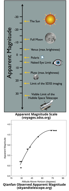
- 26 Aug: Report in Sky & Telescope by Anthony Mallama provides initial observations of the 18 Qianfan (2024-140) satellites China launched on 6 Aug 2024 (this was the LM-6A that generated ~700 pieces of debris). Per the article, amateur astronomers have shown that the satellites are bright enough to be seen with the naked-eye. While SpaceX/Starlink have engaged with the Astronomical community to lessen the impact of the Starlink satellites to terrestrial astronomy, it is unknown if China intends to make the same effort. Excerpts below. Watch Video.
– Qianfan means Thousand Sails and it will add 14,000 new communication satellites to the already crowded space in low-Earth orbit. Two more Chinese mega-constellations are planned to follow Qianfan.
– The Thousand Sails spacecraft are in polar orbits inclined 89° to Earth’s equator at altitudes near 800 kilometers (500 miles). That height is above the Starlink satellites, operated by SpaceX, and below those of the OneWeb constellation from Eutelsat.
– Experienced visual satellite observers began recording brightness once the ephemeris data became available. One observer in southwestern UK noted that the spacecraft were apparent magnitude 4.6 on August 15th. Another observer measured visual magnitude of 6.1 and 5.1 on successive passes over northern Belgium on August 16th. From Bowie, Maryland the satellites appeared to be magnitude 5.2 a few hours later and then at 5.8 on August 21st.
-The data indicate brighter magnitudes at greater heights and suggest that the spacecraft shine at about magnitude 4 near zenith. That brightness compares to the magnitude 4.3 from a video recorded as the satellites passed almost straight overhead.
– Besides the Thousand Sails project, two other large Chinese satellite constellations are under development. The China National Network Group is planning for 13,000 spacecraft in their Guowang (also referred to as SatNet) constellation. And commercial manufacturer Landray Hongqing is building the Crane-3 constellation, which will field an anticipated 10,000 more satellites according to the company’s filings. Altogether, the three constellations would tally up to 37,000 spacecraft.
The Thousand Sails spacecraft at their current brightness would seriously interfere with astronomical research as well as aesthetic appreciation of the night sky. In the U.S., SpaceX is working with astronomers to address the problem of bright spacecraft, and Starlink has succeeded in reducing the brightness of its satellites by 90%. There are, however, no regulations in place as yet that govern satellite brightness.
11 Sep:LandSpace, a commercial Chinese company, successfully performed a 10km vertical takeoff, vertical landing (VTVL) using its methane fueled ZhuQue-3 launch vehicle.The test took place at the Jiuquan Satellite Launch Center. ZhuQue-3 is a partially reusable, liquid oxygen and liquid methane powered, launch vehicle developed by LandSpace Technology Corporation. According to the company, the test was conducted with a single-stage liquid oxygen/liquid methane rocket, with a diameter of 3.35m and a length of 18.3m, made from the same high-strength stainless steel airframe structure that will be used on the ZhuQue-3 rocket.Watch Test Video.
– The total length of the flight took 200.7 seconds and reached a height of 10,002m above surface. During its descent, the rocket completed an in-flight engine ignition at a height of 4.64km, a first for China. The rocket safely achieved vertical soft landing to a recycling pad located 3.2km away from the launch pad.
– The test is seen as a key step in the development China’s commercial aerospace industry and in particular the mastering of heavy duty, low cost, high launch-frequency reusable rockets.
– Landspace conducted a successful VTVL test with the ZQ-3 in January 2024. During that test the ZQ-3 flew for 60 seconds and reached an altitude of 320m.
– With the successful 10km test, Landspace announced it is planning the maiden launch of ZQ-3 in 2025 and achieving recyclable rocket components in 2026.
– From Arstechnica report: With nine methane-fueled main engines, the Zhuque-3 will initially be able to deliver 21 metric tons (46,300 pounds) of payload into low-Earth orbit (Falcon 9 by comparison is 22 metric tons/50,300 pounds)…In 2026, Landspace aims to begin recovering Zhuque-3 first-stage boosters for reuse. Landspace is one of several Chinese companies working seriously on reusable rocket designs. Another Chinese firm, Deep Blue Aerospace, says it plans a 100-kilometer (62-mile) suborbital test of a reusable booster soon, ahead of the first flight of its medium-class Nebula-1 rocket next year.”
– Dai Zheng, who leads rocket research and development at LandSpace, emphasized the importance of the test. “The test marked the first time that any Chinese rocket has re-ignited an engine in a VTVL technology demonstration,” Dai said. “The experimental vehicle is tasked with verifying technologies and designs to be used on our ZQ 3 rocket model, which will be advanced and reusable. Performance of its components during the test is satisfactory, which means the craft is better than others of its kind in this country,” he said.

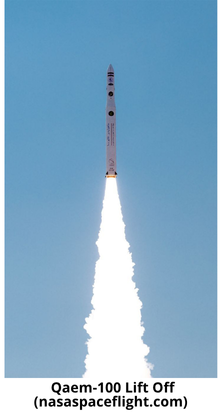
14 Sep: The Iranian Republican Guard Corps (IRGC) successfully launched a Qaem-100 with the Chamran-1 (61071) satellite into a 546 x 557km 64.1° inclined orbit. This is the second successful Qaem-100 launch in 2024 (out of 3 attempts). Launch Video.
-Chamran 1 has a mass of 60 kg and is a technology sat to test out a propulsion system.
– A state-owned subsidiary of Iran’s Defense Ministry and experts at the Aerospace Research Institute built the satellite with others to “test hardware and software systems for orbital maneuver technology validation,” state media said, without elaborating.
-Chamran-1’s other mission is to “evaluate the cold gas propulsion subsystem in space systems and the performance of the navigation and attitude control subsystems.“
– An Associated Press analysis of the video and other imagery later released suggested the launch happened at the Guard’s launch pad on the outskirts of the city of Shahroud, some 215 miles east of Tehran.
– The Qaem-100 is the IRGC’s latest carrier rocket, based on the older Qased, a proven rocket that has successfully launched satellites into space at least three times in the past.
– Like the Qased, the Qaem-100 is also a three-stage solid-fuel rocket, but has twice the payload capacity, and can reach an apogee of 750km (Qased could only reach ~500 km).
– The IRGC announced the successful testing of the Qaem-100 engine in 2022, highlighting its 68,000 kg thrust rating, compared
to older models with 30,000 kg.
-In January 2024, Iran successfully placed the Sorayya satellite into a ~750 km orbit with a 64.5° inclination. This is the highest orbit successfully reached by Iran.
– The January launch was also from Shahrud Space Center.

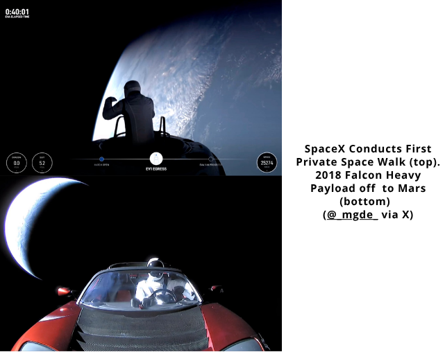
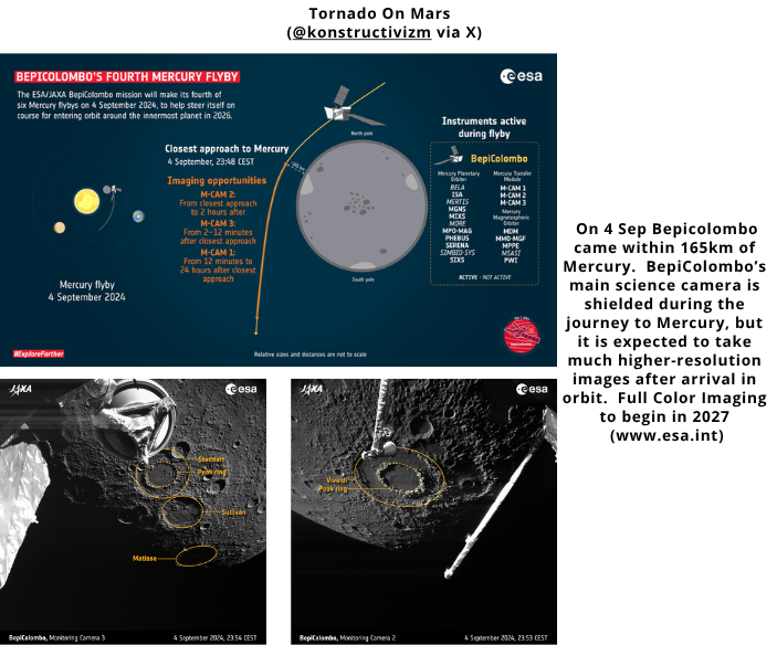
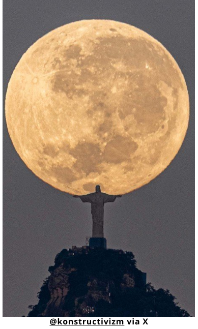
Pics o’ the Fortnight!