issue 95 | 21 APRIL 2024
The integrity flash
Analysis of Developments in the Space Domain
in this issue
15 Apr: China launched a Long March-2D from Jiuquan containing the SuperView Neo 3-01 (Gaojing-3 01) remote sensing satellite. According to official sources, the satellite entered the planned orbit and “will provide commercial remote sensing data services for emerging scenarios such as digital agriculture, urban information modeling and live 3D, as well as traditional fields including land surveying and mapping, disaster prevention and mitigation, and maritime monitoring”. Launch Video.
– Gaojing-3 01 is in a 500 x 485km orbit with a sun-synchronous orbit of 97.5°. These parameters are consistent with the satellites acknowledged imagery mission. This is now the 9th satellite of the Gaojing constellation.
– Chinese sources described Gaojing-3 01 as an optical Earth observation satellite using a three-mirror anastigmat (TMA) optical system with a very wide 130 km imaging swath and 0.5m resolution over 9 different imaging wavelength bands.
-This is the first Gaojing-3 variant, and the first of the Gaojing satellites with a 130km swath width.
– All previous Gaojing satellites are also in sun-synchronous orbit with altitudes ranging from to 444.8 to 495.7km.
– China launched the first 2 Gaojing satellites together in 2016. Then another pair in 2018 and 4 in 2022 on 2 separate launches.
-Per Andrew Jones in SpaceNews:
- The Gaojing satellites are part of a planned commercial remote sensing constellation. CASC, in its “blue book,” which outlines China’s space plans for 2024, stated it will continue work on a “four-dimensional new generation commercial remote sensing satellite system.”
- This SuperView system, according to earlier statements, is to comprise at least 28 satellites. These include high-resolution optical payloads, wide-width optical payloads, high-resolution radar payloads and other diversified types of commercial remote sensing satellites.
- It will also support the integration and value-added services of the Beidou GNSS system, and integrate satellite applications into emerging fields to support key regional economic development.

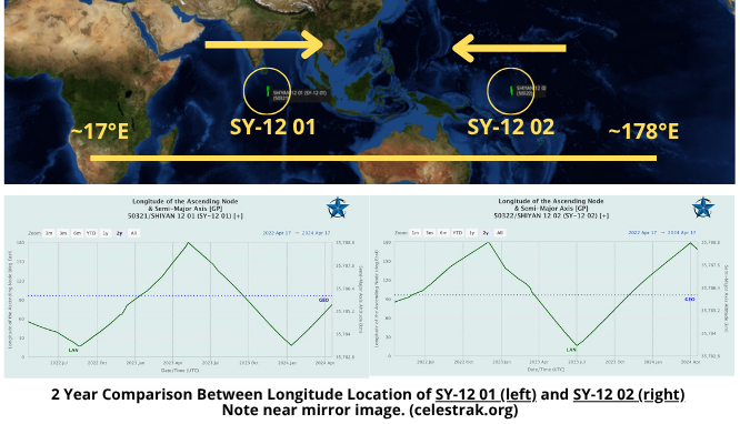
China: SY-12 01 & 02 Conduct 4 “Fly-By” Operations
17 Apr 2024: On 23 Dec 2021 (another Christmas present) China launched a LM-7A from Wenchang containing two experimental satellites, Shiyan-12 01 and Shiyan-12 02. After launch China described the purpose of the Shiyan 12 satellites as spatial environment detection and testing. There has been open source comparison with the US GSSAP mission. There was even some interesting interactions between USA270 and both satellites in 2022 (watch Video). Over the past 2+ both satellites have maneuvered along the GEO belt covering ~17°E – 178°E. The satellites travel in opposite directions and operate independently. Observers (notably the Palski Report) have noted occasional close (but always safe) encounters between the SY-12 satellites and other satellites they encounter during their travels. Thanks to the help of LSAS (Robin!) we were able to take a closer look at 4 of these recent encounters, specifically looking at the Solar Phase Angle (SPA) and whether China may have optimized the SY-12’s for optical imaging operations. Our results were largely inconclusive given our data limitations.
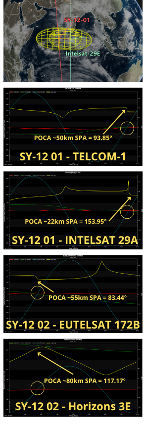
– On 11 Apr 2024 SY-12 01 orbited in proximity of two dead communication satellites in GEO:
1) TELCOM 1; and 2) INTELSAT 29E.
- TELKOM 1
- Point of Closest Approach: 50.291123km on 11 Apr 2024 at 22:02:15.424.
- Taking into account the uncertainty of the position of the satellites location as determined by ground-based sensors the minimum separation between SY-12 01 and TELKOM 1 was 28.745504km at the time of closest approach (TCA).
- INTELSAT 29E
- Point of Closest Approach: 21.957069km on 11 Apr 2024 at 22:18:54.804
- Taking into account the uncertainty of the position of the satellites location as determined by ground-based sensors the minimum separation between SY-12 01 and INTELSAT 29E was 9.656713km at TCA.
– The interactions were performed safely and posed no significant risk of collision.
– SJ-12 02 also had 2 recent encounters, but these were with active communications satellites in GEO:
1) EUTELSAT 172B; and 2) HORIZONS 3E
- EUTELSAT 172B
- Point of Closest Approach: 54.877388km on 11 Apr 2024 at 05:14:26.659
- Taking into account the uncertainty of the position of the satellites location as determined by ground-based sensors the minimum separation between SY-12 02 and EUTELSAT 172B was 43.826547km at TCA.
- HORIZONS 3E
- Point of Closest Approach: 79.823102km on 16 Apr 2024 on 05:13:22.123.
- Taking into account the uncertainty of the position of the satellites location as determined by ground-based sensors the minimum separation between SY-12 02 and HORIZONS 3E was 52.731633km at TCA.
– The interactions were performed safely and posed no significant risk of collision.
– China has not revealed any specifics regarding the mission or capabilities of the SY-12 satellites. If the satellites are collecting optical imagery the relative position of the Sun to the imager and target is critical. With this in mind we (Robin) examined the Solar Phase Angle (SPA) at time of closest approach.
– SPA is the angle between vectors of the target to Sun and target to imager. If the angle is close to 180°, then the Sun would be facing the imager and behind the target, rendering the image capture close to impossible, while the lower the angle is, the better the illumination conditions are for the observer.
– SY-12 01 SPA to TELCOM-1 was 93.85° at TCA
– SY-12 01 SPA to INTELSAT-29A was 153.95° at TCA
– SY-12 02 SPA to EUTELSAT 1721B was 83.44° at TCA
– SY-12 02 SPA to Horizons 3E was 117.17° at TCA
With our limited information we cannot confirm the SY-12
satellites are collecting imagery of other satellites. We can
absolutely say that during these close approaches there
were direct lighting conditions on all satellites, with no
umbra or penumbra making imaging a possibility. We did not detect any maneuvers leading up to or during TCA. What we have is a series of “close” approaches which could be sufficient enough for imaging. (Thanks again to Robin and Jason for their assistance!)
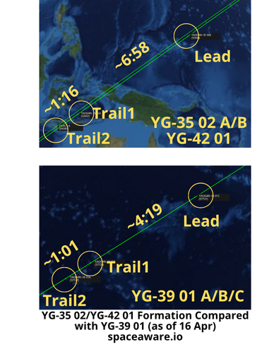
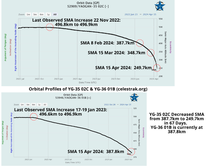
16 Apr: After 2 weeks in orbit YG-42 01 appears to be joining the YG-35 02 formation. The original Trail2 satellite (YG-35 02C) is now listed as “dead” in the spacetrak.org catalog and re-entered the Earth’s atmosphere on 19 April 2024 (see next page). YG-42 01 is slightly off-set from the remaining YG-35 02A & B satellites but appears to have matched its altitude with the other YG-35 02 satellites to maintain relative distance.
– On 20 April the SMA for YG-42 01 was 496.0km an increase of .7km from 15 Apr. YG-35 02B (Lead) has an SMA of 496.2km and YG-35 02A (Trail1) has an SMA of 496.1km.
– YG-42 01 has a slightly different RAAN (67.3°) than the YG-35 02 A/B satellites (65.4°).
– The YG-35 02 formation is in the same orbital plane as YG-39 01 and YG-36 02.
– As previously reported the YG-36 02 formation has also lost its Trail2 satellite, at least temporarily. However, the YG-39 01 formation appears to be intact.
– China has matched YG-42 01’s altitude with YG-35 02 A/B and the current spacing between Lead-Trail1 and Trail1-Trail2 is within the same range as the intact YG-36 05 and YG-39 01-05 triplets.
– YG-42 01 is likely a new Trail2 satellite for YG-35 02 restoring whatever capability was lost with the failure of YG-35 02C.
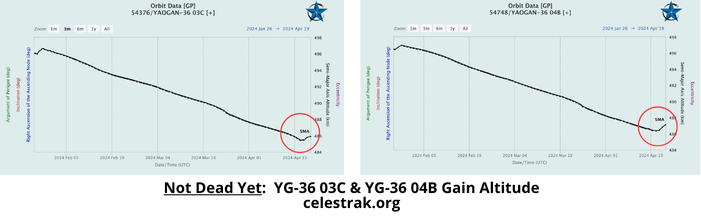
– 5 of the 7 remaining Trail2 satellites, which began decreasing their altitudes in late-Jan 2024, have not maneuvered and continue to gradually decrease in altitude. All are now lower than during the previous “slide” which occurred Jan-Mar 2023.
– 2 of the 7 Trail2 satellites, YG-36 03C and YG-36 04B, did increase their SMAs beginning on 17 Apr 2024. We will continue to monitor. As of 20 Apr neither YG-36 03 or 04 triplet was close to being in formation.
Editor’s Update: China launched YG-42 02 on 20 Apr. Its orbit nearly matches YG-36 01A & C.
20 Apr: Yaogan-35 02C re-entered the Earth’s atmosphere just after midnight UTC on 20 April. The satellite last maneuvered in late November 2022. On 15 Mar 2024 the former “Trail2” satellite had a Semi-Major Axis (SMA/altitude) of 348.7km, one month later the satellite lost nearly 100km of altitude and was at 249.7km on 15 Apr. As YG-35 02 continued to descend it encountered more of the Earth’s atmosphere resulting in greater drag and further orbital decay. The last observation of the satellite was on 18 Apr and its altitude was just 156km. I’m also keeping an eye on YG-36 01C, another Trail2 satellite that has been slowly losing altitude. But don’t take my word for it. I ran into the one and only Jack Anthony at Space Symposium this year and we got to talking. And then Jack was nice enough to get writing, see below for his observations (which were made prior to YG-35 02’s ultimate demise).
It’s A Drag
by Jack Anthony
Greg Gillinger and I were chatting during Space Symposium week, always fun! He asked me “so Jack, how low can a satellite go before it reenters?” Hummm, my general answer is 150 to 200 Km. But, there’s a lot of “it depends” involved with my answer. At this altitude you might say the steady decay of the orbit’s semi-major axis as it spirals in really steepens, poof, it’s gone. Greg has been keeping an astro eye on Yaogan 35-02C, object # 52909 as it is entering this steep decay and reentry. Celestrak’s prediction is that it may be done by time you read this issue of the Flash. Normally satellites execute periodic orbit raises to prevent reentry and stay in mission. Greg alerted me that Yaogan 36-01B (#53946) has also been on a steady descent in orbit mean altitude. It’s presently at 389 Km and at a rate of descent where in 2 to 2 ½ months it too will spiral in and decay in the Earth’s atmosphere. Something to keep an eye on. Let’s learn more!
Imagine you get on an elevator with me and you ask “Jack, how hard is it to predict when an object will burn in?” Let’s go for a few floors and let me entertain you with an answer. My answer is “It’s a challenge and we astrodynamics minded geeks give it our best as we apply mathematical models of the upper atmosphere (mesosphere) where satellites are zipping through at 7+ km/sec. Much work goes into trying to model atmospheric drag at orbital altitudes, big brains continue to work the challenge. Many models have been developed. When I learned astro in the 70’s, the preferred model was called Jacchia 1971. Many more math models exist today. There’s also a significant degree of uncertainty in how we measure Sun and Earth things than can influence how high up the atmosphere goes and its density. Many Sun solar flux and Earth geomagnetic parameters feed the models. OK, one floor just went by, but we keep climbing so I keep talking…lucky you!
The mathematical equations to predict a space objects motion is based on the two-body problem, the Earth’s gravity and the object. We got that down pretty good. But, the equations contain many more terms to model other forces acting on the object other than the big gravity! For example, we model how the Earth’s oblateness or football shape affects the motion. This is called J2. You can go many levels of details on the Earth’s shape and model the resultant gravity pattern to very precise levels (e.g., J3, J4 and higher order degree J22 and J “much bigger
number” pair. Geo-scientists got this down pretty good and they keep getting more exact and detailed. There is also the Sun and Moon tugging on the object as it orbits. Their gravity comes into play. The Sun and Moon gravity really affects the GEO birds inclination and sometimes a GEO satellite must bring a lot of propulsion and fuel to combat that. LEO satellites experience this third-body effect, but not as much as the GEO spaceships. Some models allow you to include gravity of Jupiter and other biggies out there. Again, our scientists get deep down into the details of who’s gravity is tugging on our spacecraft and objects out there. Now we get to the fun thing to model, atmospheric drag! We’re basically talking 600 Km and below. That’s where those little air molecules bonk the satellite and take out a wee bit of energy. Then it’s game on, the circularization of the orbit begins and then spiral decay. That’s where we can say “it’s a drag.” Hey look, another floor went by, we are still climbing and you are not getting off…. good for you! I am now going to dive deeper into the fun-filled topics behind modelling and predicting atmospheric drag as it effects a space object in LEO.
To try and explain atmospheric drag in a few short floors of an elevator ride is tough. There are semester long astro courses and grad students spending months and years on the topic. Modeling drag for determining the motion of space objects is as much art as it is science. Some say it’s “voodoo magic”, others say luck is as much a part of if it as solid thinking and selection of the best model and parameters. It involves some tremendous effort by scientists and engineers to model the upper atmosphere and be able to most effectively predict the trajectory of a space object and when it will succumb to the forces of the atmosphere and burn in. As I said earlier, uncertainty is a constant companion of the effort. There’s uncertainty in the models, they are all different and they all are amazing mathematical tools. There is uncertainty in the measured parameters of the Sun “storminess” (that parameter is the F10.7 Solar Flux) and the Earth’s geomagnetic activity (Ap and Kp index) where the is a big “plus or minus” factor applied. Mother Nature is a busy lady and keeps calling audibles when it comes to Sun and Geomagnetic activity. She hides her data cards!
Let’s look at what space object and space weather parameters “feed” the atmospheric models and how they help us predict the orbit’s path and ultimately the space object’s lifetime. A model or a big ole’ equation needs inputs in order to work. Things that matter! So, the first thing is “where is the space object and how fast is it going?”… this is the state vector, position and velocity in a defined coordinate frame. It’s the best estimate of that. The model essentially asked “I need to know the situation.” So, state vector is the first thing. Then it seeks info on the object in question. “What is the mass?” and “What is the cross-section area?” Hummm, mass is easy, but this cross-section area is something you may not be familiar with. It’s the area that is being presented “into the wind,” or more accurately into the direction of the velocity vector. These two terms: Area (A) and Mass (m), are the key components of a drag term, something the astro dynamos call the “B-star.” It plays a key role in how fast a space object will decay. The greater the A, the higher the force due to atmospheric drag. The higher the mass, the less the force. That is pretty darn simplified, but basically true. Sometimes the A and the m are not exactly known, perhaps it’s a satellite of a nation that is not so giving of that kind of info. Well, “we got people” that figure that out…and to very good accuracy. Greg is one of those “people.” Now, we have a space object state, we may some insight into A and m. So, the key contributor to what the atmosphere is doing is the Sun’s & Earth’s geomagnetic activity. There are many parameters
that capture the things that effect the atmosphere. The two biggies are Solar Flux and Geomagnetic Index. The Space Weather Prediction Center of NOAA is the organization that keeps track of these parameters. It’s no easy chore. I know you all are users of the amazing Celestrak.org website, they have a link to the NOAA info. Solar Flux is the parameter that feeds the equation and gives it insight into ther “storminess” on the sun. The sun spots and the solar flares, stuff like that. Yup, what’s happening on the Sun drives the atmospheric model. It also gets the Geomagnetic situation around the Earth all excited. That’s where the Ap index helps us understand how the atmosphere is behaving. All this is used to determine the force on the space object. Thus, it determines how the position and velocity vectors are affected.
Guess what, the elevator door is opening and it’s time for you to get out and run away from ME. I hope my rambling regarding how we handle atmospheric drag was helpful. As space professionals in the operations and intelligence roles, its important for you to appreciate and understand what’s driving all this when’s it going to reenter stuff. So where to from here? Well, remember Yaogan-36 01B, # 53946? It’s quit doing any form or orbit maintenance and is subject to the atmospheric drag game…it’s decaying and “coming in.” Why not get on Celestrak and monitor things like mean motion and orbit period and watch it get sucked in by the Earth’s atmosphere. You just might learn something!
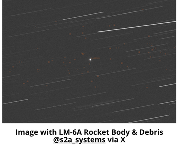
13 Apr: S2A Systems, a Swiss space domain awareness company, released analysis and images which reportedly show that the LM-6A (2024-058B) upper stage had suffered some sort of debris generating event. Per S2A’s tweet: “Images from April 7 showed nearly 60 objects around the upper stage. These are only the objects that were large enough to be detected visually with the existing setup.” Editor’s Note: I have not seen confirmation of this event in the Spacetrak.org catalog.
– China had used this particular LM-6A to place the Yunhai-3 02 satellite into orbit on 26 March. Unfortunately, Yunhai-3 02 (and the LM-6A) are in a popular sun-synchronous orbit with an altitude of ~845km. At this altitude any debris will take decades to de-orbit.
-This is not the first debris generated event from a LM-6A upper stage. On 11 Nov 2022 China launched the first Yunhai-3 satellite from Taiyuan. On Nov. 12, the U.S. Space Force’s 18th Space Defense Squadron (18 SDS) reported that it was tracking at least 50 discrete pieces of orbital debris from the rocket body.
– Ongoing tracking revealed that the debris
cloud has grown to 350 objects associated with the rocket stage.
– China: Let’s try and leave things better than we found them in the future.
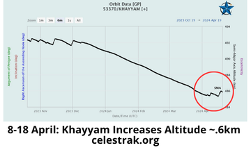
19 Apr: After months of slowly losing altitude, the Iranian operated/Russian launched Khayyam ISR satellite increased its SMA. Thanks to the tip off from Orbital Focus.
– Per Orbital Focus, Khayyam is an “Iranian Government owned imaging satellite built and managed by Russia The design is based on Russia’s Canopus V. The imaging payload is operated by Iran. Thruster firings to maintain the orbit ceased 9 Dec 2023 and it entered a period of natural orbit decay until 4 April 2042 when the thruster was activated briefly to arrest the descent.”
– It is unknown if Iran used Khayyam to assist with targeting Israel for its attempted
13 April 2024 air strikes. The timing of the maneuver could be completely coincidental…or not.
– The Khayyam’s camera has a resolution of 1.2m, according to Western security officials, which is a substantial improvement over Iran’s previous capabilities.
– With operational control of the satellite, Iran has the ability to “task” the Khayyam and conduct surveillance on locations of its choosing, including military facilities in Israel, oil refineries and other vital infrastructure in neighboring gulf states.
– Khayyam is in a 483x482km 97.4° sun-synchronous orbit.
17 Apr 2024: The Center for Strategic & International Studies (CSIS) released its annual Space Threat Assessment. This is the 7th edition of this most excellent report. CSIS always does an amazing job of presenting the fundamental elements of space and counterspace capabilities (to include doctrine and organization) and then weaving in recent operations to further prove the case. Information cutoff for this report was 30 Mar 2024. Excerpts below.
-Overview:
- Civilian and commercial space systems face expanding threats from foreign adversaries, which increasingly include cyber and espionage threats
- 2023 saw foreign nations reach new milestones in space: record-setting launches, deployments of satellites, and missions to the Moon and other parts of the solar system
- A pattern has emerged that suggests the normalization of certain counterspace activities that had heretofore been uncommon…cyberattacks, jamming and spoofing activities, and unfriendly behaviors in space have now become commonplace and rarely trigger an escalatory or retaliatory response. These activities have become normalized.
-China:
- According to U.S. Space Command, as of January 2024, China had approximately 360 ISR satellites on orbit, more than triple the number in 2018.
- Notably, in August 2023, Beijing launched the world’s first GEO-based synthetic-aperture radar (SAR) satellite, Ludi Tance-4, and in December 2023, it launched an optical imagery satellite to GEO, Yaogan-41. Some analysts estimate resolutions of 20 meters for Ludi Tance-4 and possibly 2.5 meters for Yaogan-41.
- When paired with other Chinese ISR satellites, artificial intelligence to quickly identify objects, and networked communications systems, the PLA could possess near-real-time situational awareness of the vast Indo-Pacific theater.
- November 2023, China is believed to have launched its first batch of satellites to test internet connectivity from space as part of a planned 13,000-satellite national LEO broadband constellation, GuoWang.
- China was likely responsible for GPS interference in the Indo-Pacific region noted by commercial pilots last year.
- Chinese warships engaged in radio signal and GPS jamming over the South China Sea, Philippine Sea, eastern Indian Ocean, and northwest of Australia.
-Russia
- Sanctions continue to block access to Western technology critical to Russia’s ability to build modern satellites. The bedrock of Russian strength in space, including its counterspace capabilities, is Soviet-era technology and infrastructure.
- Russia understands the importance the United States places on space capabilities to enable air and missile strikes as well as joint operations…[and] would likely seek to degrade or destroy an adversary’s space capabilities at the start of a conflict, even before military hostilities begin.
- With the Luch/Olymp and Cosmos 2562 & 2570 satellites, Russia could be testing and validating tactics, capabilities, and operational procedures that it could use to enable future orbital counterspace weapons.
- Some theorize that Russia is considering a nuclear weapon in space, while others suggest that Russia is developing a nuclear-powered electronic warfare satellite.