Analysis of Developments in the Space Domain
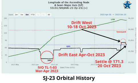
20 Oct 2023: China’s Shijian-23 (SJ-23), characterized as an experimental satellite in GEO, conducted a series of maneuvers 11-20 October, eventually rejoining the GEO belt at 173.3°E and in the vicinity of (IVO) China’s Tianlian-2-02 data relay satellite. Interestingly, from March-April 2023, SJ-23 appeared to coordinate its orbit with another Chinese data relay satellite, TL-1-03, and had a reported Point of Closest Approach (POCA) of <4 km. It remains to be seen how long SJ-23 remains in its current orbit, or if there is any interaction with TL-2-02. Watch amazing video of SJ-23 & TL-1-03 interaction in March (thank you Alex Ridgeway & LSAS!)
– China launched Shijian-23 from Wenchang using a LM-7A on 9 Jan 2023. SJ-23 was the first Shijian satellite to be launched on a LM-7A Space Launch Vehicle (SLV).
-Initially, analysts believed SJ-23 was a communications test satellite and a follow-on to the SJ-13.
-However, on 19 Jan 2023 SJ-23 released a small object. The release of a sub-payload is more indicative of SJ-17, TJS-3, and SJ-21.
– SJ-17 has conducted several Rendezvous Proximity Operations (RPO) of other satellites (primarily Chinese) in GEO since its launch in 2016.
-TJS-3 conducted RPO with its “apogee kick motor” shortly after arriving on orbit in 2019. Video. TJS-3 revisited the AKM in again in October 2021.
– On 18 Mar 2023, SJ-23 had a Point of Closest Approach (POCA) of 3.537kms with TL-1-03. The two satellites were
never co-planar as TL-1-03 inclination was 2.7° and SJ-23 was 0.9°.
– After its encounter with TL-1-03, SJ-23 lowered its altitude for 6 months, and drifted from 19.8°E to 174.4°E.
– On ~11 Oct SJ-23 increased altitude more than 100 km to place it 32 km above GEO, and initiate a westward drift.
– SJ-23 maintained this altitude until ~19 Oct when it lowered its altitude 32 km to join the GEO belt.
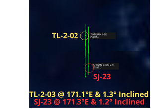
– As of 20 Oct, SJ-23 is at 171.3°E. TL-2-02 is at 171.1°E.
– Unlike SJ-23’s encounter with TL-1-03 in March, the inclination of TL-2-02 is similar to SJ-23 with only a 0.1° difference.

15 Oct 2023: China launched a LM-2D from Jiuquan Satellite Launch Center carrying the Yunhai-1-04 environmental monitoring satellite. Chinese media labeled the payload an “atmospheric, marine, and space environments, disaster prevention and mitigation satellite.” This stated purpose might be a placeholder to avoid revealing the spacecraft’s true intentions. The payload weight, and technical specifications, are unknown. The Yunhai series are assessed to have military purposes. Launch Video.
– Yunhai 1-04 is in a similar Sun-synchronous orbit as its predecessor, Yunhai 1-03 (launched 20 Sep 2022) with an orbit of ~780 km and inclination of 98.6°.
– Yunhai 1-01 was launched in 2016 and is still listed as active.
– Yunhai 1-02 was launched in 2019 and in March 2021 suffered a suspected collision with a small piece of debris from a Russian Zenit satellite.
– Amateur radio trackers continue to detect signals from the satellite, but it is unclear if Yunhai 1-02 is operational. The publicly available satellite catalog still lists it as active (11 of 37 pieces of debris remain in orbit).
– Yunhai 1 satellites have been built by the Shanghai Academy of Spaceflight Technology, possibly based on the CAST2000 platform.
– Data provided by Yunhai 1 satellites complement information provided by the civil Fengyun meteorological satellites.
-China also has six Yunhai 2 satellites on orbit. All were launched in 2018 on the same LM-2D from Jiuquan. The first three were sent to a circular orbit with a height of 520 km, and the other three were sent to a circular orbit with a height of 1095 km. All are now operating at an altitude of ~800 km.
-There is a single Yunhai 3 satellite on orbit. Launched in November 2022 it is in a Sun synchronous polar orbit, with a 847 km perigee and 863.5 km apogee, and 98.8° inclination. There are rumors it is a SAR radar imaging satellite.
-Yunhai 3 also had a notable debris-generating event, as the LM-6A’s upper stage suffered a breakup event and is now in more than 50 pieces at altitudes ranging from 310-435 miles (500-700 km).

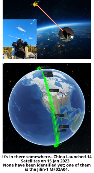
17 Oct 2023: The South China Morning Post describes a recent test where a CGST Jilin-1 imagery satellite transferred data via laser to an optical telescope, at a data rate of 10 GBps.
– CGST, operating the imaging satellite constellation Jilin-1, sent remote sensing images from one of its 108 Jilin-1 satellites in orbit to a vehicle-mounted optical telescope at the speed of 10 gigabytes per second, per a company spokesman’s WeChat post.
– According to the company, the transportable station is compact, has a high bandwidth, and can be deployed anywhere to avoid clouds, atmospheric turbulence or extreme weather. CGST said the station could better support satellite-to-ground laser communications.
-“The data rate in this test reached 10 gigabytes per second, which is more than 10 times higher than that of the radio-frequency links traditionally used for satellite communication,” said Wang Xingxing, technical director of CGST’s laser communications ground station unit.
-“In the future, Chang Guang Satellite plans to expand the bandwidth to 40-100 GBps, and use such ground stations at various locations across the country to substantially boost its image-acquisition efficiency,” Wang said.
-The company gave no details about the ground station configuration, such as the telescope’s aperture or pointing accuracy, or what kind of vehicle was used to transport the station.
-The Jilin-1 MF02A04 satellite was used in the June and October tests. It was launched into orbit from the Taiyuan Satellite Launch Center in January 2023.
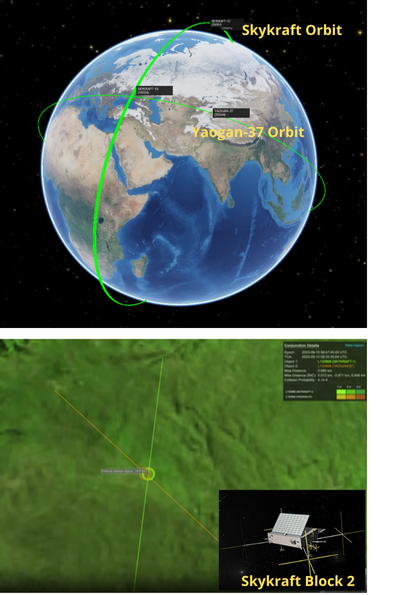
17 Oct 2023: It appears both a Chinese and an Australian satellite operating in low Earth orbit (LEO) maneuvered to avoid a potential collision on 9 Oct 2023. Post-event analysis conducted by LeoLabs shows both satellites were predicted to have an “miss” distance of just 100 meters, 24 hours before the anticipated “conjunction.” Analysts believe the Chinese satellite involved was the Yaogan-37, launched in January 2023. The Australian satellite was one of eight Skykraft satellites, all of which were launched in March 2023.
Watch News Report with Graphics. Also give a listen to the most excellent T-Minus podcast.
– Addressing the Space Industry Association of Australia, Air Vice-Marshal Catherine Roberts described how Defence Space Command worked with Canberra based company Skykraft to manage the incident.
-Skykraft chairman Mark Skidmore says good communication with Defence Space Command, as well as the United States Air Force (USAF), was crucial to dealing with the “real-time congestion” threat.
-“We had communication with Space Command, with USAF at the same time because they were providing and feeding us information, so we had all the information we needed to understand our course of action.”
-According to the data, the Yaogan 37 satellite maneuvered 16 hours prior to the conjunction, increasing the miss distance to 978 meters at the closest approach.
“Unfortunately these type of critical conjunctions occur on a nearly daily basis in low Earth orbit,” says Terry van Haren, the managing director of LeoLabs Australia.
-“We are seeing more and more of this because space is becoming more crowded… we’re seeing a lot more of these conjunctions occurring on a regular basis and I think the problem is only going to become more
challenging in the future,” added Australian Strategic Policy Institute analyst Malcolm Davis.
– There is very little publicly available information regarding the mission and capabilities of the Yaogan-37. It was launched on 12 January 2023 on a LM-2D. Also on that launch were the experimental satellites Shiyan-22A and 22B. All three have unknown missions. The orbit for all three satellites appears to be unique from previous Yaogan and Shiyan missions.
-While the altitudes of the Shiyan-22 satellites do not intersect with the Skykraft constellation, YG-37’s 523.5 x 507.5 km altitude does intersect with Skykraft operating range of 523.4 x 507.7 km.
17 Aug 2023 (OK, I missed this one!): News reports detail the potential collection from hundreds of Chinese satellites of the TALISMAN SABRE and MALABAR exercises in and around Australia. The report highlights the possible collection by the Yaogan-35, Yaogan-36, Jilin-1 and other Chinese Earth observation satellites. The report also noted China re-positioned three of its geostationary satellites during the exercises, specifically naming Shijian 17, Shijian 23, and Shiyan-12-01. Watch News Report with Graphics.
– In July, Canberra-based defence company EOS Space Systems tracked three Chinese GEO satellites maneuvering into position below the equator, to monitor the Talisman Sabre war games across northern Australia.
-Analysts detected the Shiyan 12-01 satellite drifting westerly over the northern Australia region, while the Shijian-17 and Shijian-23 satellites were tracked drifting easterly to observe multiple areas where Australian and coalition forces conducted exercise activities.
-Since Exercise Malabar began on 10 August, hundreds of much smaller low-orbit satellites (LEO) have also been tracked completing thousands of flights at much lower altitudes over the Australian continent, focusing on the activity of warships around Sydney Harbour.
– “We’ve seen over 300 satellites
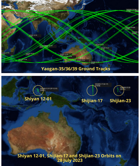
surveying ground-based activities and the number of overflights is over 3,000 since the start of the Malabar exercise centred around the Sydney Harbour bay area,” James Bennett from EOS Space Systems said.
– Exercise Malabar involves joint naval exercises between Australia and warships from the United States, India and Japan.
As previously discussed, Shijian-17 and Shijian-23 are likely being used to operate near and observe other satellites (SJ-17 is also known to have a mechanical arm) and are unlikely to be well suited for an Earth observation mission. Little is known about the Shiyan 12-01, though China announced it was intended for spatial environment detection and testing. There has been open source comparison with the US GSSAP mission.
18 Oct 2023: Several sources noted unusual activity involving one of Russia’s GEO based signals intelligence satellites, Luch/Olymp K2 (aka Luch 5X), and a western communications satellite, Eutelsat 3B. Luch 5X increased its altitude on ~25 Sep 2023, initiating a westward drift. It then gradually lowered its altitude a few days later and settled back into GEO at 3.2°E, in Eutelsat 3B’s vicinity. During the course of its travels, Luch 5X may have had a point of closest approach (POCA) of 16 km to Eutelsat 3B. Prior to its journey to 3.2°E, Luch 5X had been at 9.0°E and in the vicinity of Eutelsat 9B. Watch most excellent video from TJ Koury.
– Russia launched Luch 5X on a Proton-M rocket from the Baikonur Cosmodrome on 12 Mar 2023. The Olymp-K
satellites are Russian geostationary satellites built for military and intelligence use.
-Russia did not disclose the purpose of the satellites,
however they are believed to serve two purposes: conducting signals intelligence (SIGINT); and providing secure communications lines for government use.
-After arriving on orbit, Luch 5X settled in the following GEO slots:
– Russia maneuvering Luch 5X near western communications satellites is consistent with its predecessor Luch/Olymp K1, launched in Sept 2014.
– Seven months after launch, Russia positioned Olymp K1 at 18.1°W, directly between the Intelsat 7 and Intelsat 901 satellites, which are located within half a degree of each other in geostationary orbit.
-Olymp K1 has visited several western communications satellites, and is currently operating in the vicinity of Intelsat 37E.

Inspector satellites with an imagery mission, such as the US GSSAP spacecraft, typically drift by, take pictures, and continue on their way. A signals intelligence spy satellite will likely loiter for long periods of time near its target satellite or group of satellites.
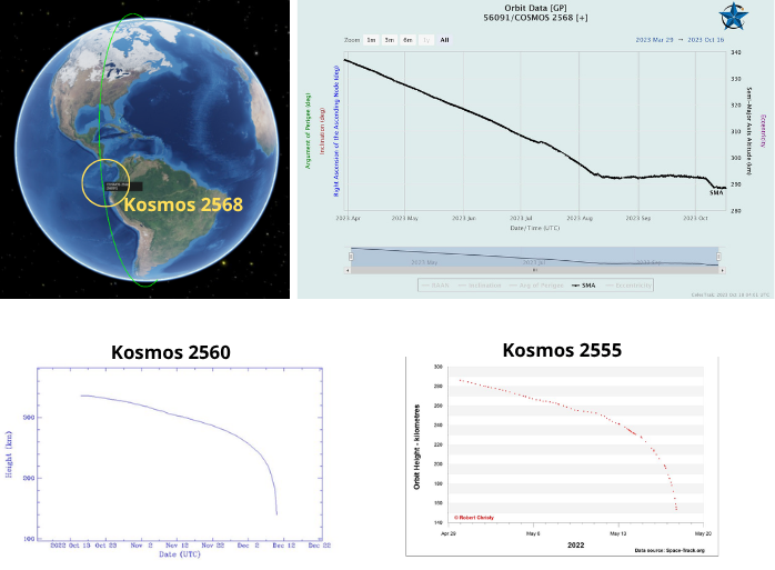
17 Oct 2023: Over the past two years, Russia launched four classified satellites believed to be EO MKA experimental/prototype spacecraft. The first three, Kosmos 2551, 2555 and 2560 re-entered the Earth’s atmosphere after 19, 41, and 56 days, respectively. Kosmos 2568 launched on 29 March 2023 and for the first 5 months seemed to be on a similar journey. However, the satellite appeared to maintain its altitude from mid-August until early-October. The satellite then decreased its altitude for a few days before apparently stabilizing again.
– Kosmos-2568 initial orbit was 340.7 x 325.8 km orbit with an inclination of 96.5°. Its inclination has not changed significantly – it is currently 96.4°.
-From 30 Mar – 11 Aug the satellite’s Semi Major Axis (SMA) decreased ~43.5 km to 293.6 km.
-Then from 12 Aug – 5 Oct Kosmos 2568 SMA decreased only 0.5 km to 293.1 km. During this time period there were actually some reported slight increases in SMA.
-From 5 Oct – 10 Oct the satellites SMA decreased 3.5 km to 288.6 km. Then on 11 Oct the SMA increased slightly, and seems to be holding at ~288.5 km.
-It appears Kosmos 2568 has some ability to maneuver.
-None of the previous satellites, believed to be similar to Kosmos 2568 (Kosmos 2551, 2555 and 2560) performed any life-extending maneuvers during their time on orbit. We do not know if Kosmos 2568 is equipped differently than the other three satellites, or if the previous three experienced some anomaly which prevented them from increasing their altitude.
Resurs-P3 and Kosmos-2562 may have engaged in multiple rendezvous, proximity operations, and separations. Due to the proximity of the satellites and the inaccuracies inherent in TLE measurements, it is difficult to characterize the engagements. From limited publicly available information, it appears only Kosmos-2562 is performing the co-orbital maneuvers.