issue 70 | 9 APR 2023
The integrity flash
Analysis of Developments in the Space Domain
in this issue
Russia Launches Classified Satellite
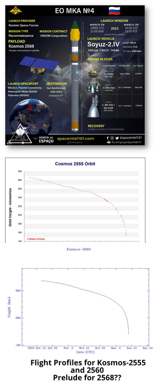
29 Mar 2023: Russia launched a Soyuz-2.1v rocket launched from Plesetsk, carrying an unknown payload designated Kosmos-2568 to a Sun-synchronous orbit (SSO). There are rumors the satellite may be another inspector satellite similar to Kosmos 2558, 2561 & 2562, however Kosmos-2568’s orbit more closely matches the EO MKA experimental/prototype spacecraft (all of which re-entered after only several weeks on orbit.) Launch Video.
– Kosmos-2568 is in a 340.7 x 325.8km orbit with an inclination of 96.5°.
– Suspected inspector satellites, Kosmos-2519, 2542, 2535, 2558, 2561 & 2562 and their subsatellites, all launched on the Soyuz-2.1v rocket from Plesetsk. This has led to speculation that Kosmos-2568 might also be another inspector satellite.
-However there is mounting evidence that Kosmos-2568 is likely another imagery prototype satellite similar to Kosmos-2551, 2555, and 2560.
-The three prototypes are also known as EO MKA (which presumably stands for “protype of a small satellite”). Kosmos-2568 appears to be EO MKA #4.
-Kosmos-2568 launched at a time of day similar to Kosmos 2551, 2555, and 2560 and has similar apogee, perigee and inclination values.
-The suspected Russian inspector satellites all are in higher orbits than Kosmos-2568 and, more importantly, are at different inclinations…2558 is off 8.7° and 2561/2562 are 4.2° off from Kosmos 2568.
-The mission for these short-lived spacecraft remains unknown. One poster on the NK forum claimed they are used as targets for the Peresvet anti-satellite laser system, but that this is only a secondary mission objective.
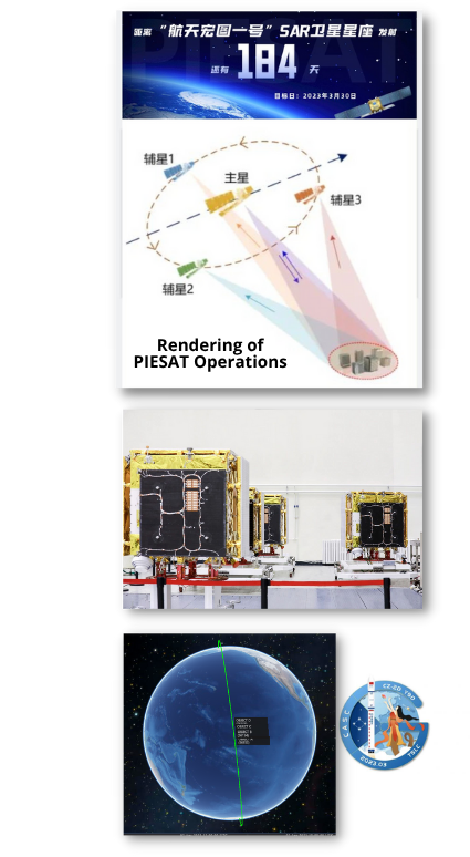
China Launches 4 SAR Satellites...Orbit in Formation
30 Mar 2023: China launched a Long March 2D from Taiyuan carrying 4 PIESAT-1 Synthetic Aperture Radar (SAR) imaging satellites into low earth orbit. The four satellites will work together to deliver .5m resolution SAR imagery. The developer of the payloads was GalaxySpace, who will also operate them. Launch Video. Watch Formation Formation and Operation Video.
– The PIESAT (also known as Hongtu-1 01A-D) spacecraft are X-band synthetic-aperture radar satellites with a resolution of 0.5-5m. All are in a 528km Sun Synchronous Orbit.
-The four satellites form a single module. The module consists of one main satellite and three sub-satellites oriented around the main module. The main satellite will act as the transmitter, while the three passive satellites are the receivers.
-The satellites are intended to map global non-polar regions at a scale of 1:50,000.
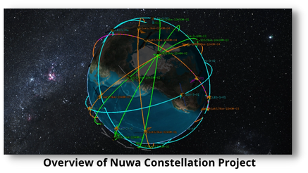
-PIESAT may be part of the larger “Nuwa Constellation” from Aerospace Hongtu.
– The first phase of the “Nuwa Constellation” project plans to launch 38 operational satellites. These include a radar remote sensing constellation composed of 28 SAR satellites and 10 optical satellites. The objective is a constellation with a SAR resolution better than 0.5 meters and 2-meter resolution for the eight-band optical satellites.
-The 4 PIESAT satellites were launched on schedule, the remaining 24 SAR satellites will launch in 2024 and 2025.
-The Nuwa Constellation Project aims to achieve rapid global revisiting of Earth observation, and use laser intersatellite communication networking to build a global autonomous and controllable real-time remote sensing hybrid constellation.
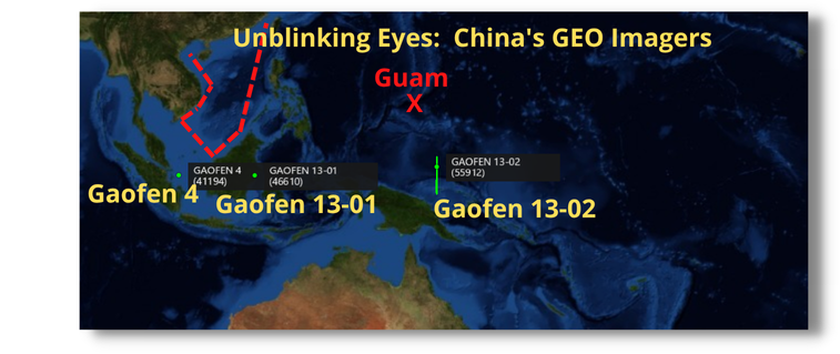
China's Gaofen 13-02 Expands China's Surveillance Area
5 Apr 2023: GF-13-02 settled into its GEO slot at 146.7°E, expanding China’s coverage of the Western Pacific. China launched GF-13-02 on a Long March 3B from Xichang on 17 March 2023. CASC announced only that GF-13-02 was a high-resolution, high-orbit optical optical remote sensing satellite with great significance to the development of China’s space technology. GF-13-02 joins Gaofen-13-01 (2020) and Gaofen-4 (2015) as other optical satellites in GEO. China has also announced plans to place a SAR imaging satellite into GEO this year as well.
– GF-13-02 currently is currently far more inclined (3°) than the other GEO imagers (GF-4 & 13-01 are both .1°) This will likely change in the coming months.
– The Initial inclination value is chosen to keep the average value near zero over mission lifetime.
– At the beginning of its mission in 2020 GF-13-01 was inclined at 2.0°.
– GF-4 is believed to have a maximum resolution of ~50m, while the GF-13 satellites are believed to have a 15m resolution.
– China placed GF-13-02 significantly further east than GF-13-01 which will enable surveillance further from
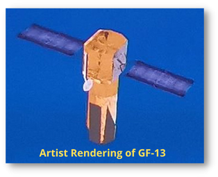
China’s coastline. GF-13-02 is <2° East of Guam and <1° East of the Northern Marianas Islands.
– China’s recently released “Blue Book”– an annual snapshot of CASC activities – said remote sensing was enhanced of the Diaoyu Islands in the East China Sea, as well as the South China Sea’s Scarborough Shoal, Macclesfield Bank, the Paracels and Spratly Islands, and the surrounding waters.
– The enhanced satellite program provides important data for the administration and management of the waters and islands, as well as “islands of special purposes” – which China uses as territorial sea bases.
-CASC also reported that its satellites now form a continuous high-frequency observation capability with global coverage.
-China’s claims – represented by a nine-dash line which includes most of the strategic waterway – have made the region a potential hotspot, with the US frequently sending warships on “freedom of navigation” exercises to challenge them.
-China is planning to further expand its GEO imaging constellation and also announced plans for a GEO SAR satellite capable of 20m resolution. Launch is planned for 2023.
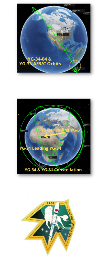
China Launches Yaogan-34-04 Reconnaissance Satellite
15 Mar 2023: The final launch was the Yaogan (YG) 34-04 mission, carrying a SAST-built optical remote sensing satellite to LEO. The official use case for this satellite is “land census, urban planning, road network design, crop yield estimation, and disaster prevention and mitigation,” a commonly used placeholder for satellites that carry a military classified use case. Launch Video.
– YG-34-04 current (as of 2 Apr 2023) orbit is lower than YG-34-01, 02 & 03. Currently YG-34-04 is in a 1,095x914km orbit but has an identical 63.4° inclination.
– The earlier Yaogan-34 series satellites are in 1,120 by 1,050-kilometer orbits and are also inclined by 63 degrees. The orbit closely matches that of three sets of Yaogan-31 designation satellite triplets.
– All four YG-31 triplets are accompanied by a YG-34 satellite.
- YG-34-01 trails YG-31 D/E/F
- YG-34-02 trails YG-31 G/H/J
- YG-34-03 trails YG-31 J/L/M
- YG-34-04 trails YG-31 A/B/C
– As we saw with all previous YG-34 satellites, expect YG-34-04 to gradually close the gap between itself and the YG-31 triplet it follows.
-The Yaogan-31 satellites’ orbits suggest they are analogous to US DoD Naval Ocean Surveillance System (NOSS) satellite triplets. Watch Video of Satellite Triplets (YG-16 & YG20).
– NOSS satellites locate and track ships at sea by detecting radio transmissions and analyzing them using time-difference-of-arrival (TDOA).
-China’s official release stated the Yaogan-34 series “is mainly used for land census, urban planning, and land confirmation. It can meet the needs of rapid earth observation revisitation and provide information for China’s “Belt and Road” construction.
– This suggests Yaogan-34 is an optical remote sensing satellite.
-Pairing an optical remote sensing satellite with the Yaogan 31 triplets could yield the ability to “tip and cue” between sensors and use imagery to confirm ship or other target locations and identities.
-All YG-34 and YG-31 satellites were launched from Jiuquan and used a LM-4C launch vehicle. YG-34 satellites were built by SAST while CAST manufactured the YG-31 satellites.
China is developing several symbiotic constellations made up of dissimilar satellites. The missions of these satellites and their capabilities have not been made public. However, like YG-31 and YG-34, the satellites have different manufacturers (CAST and SAST respectively.) YG-35 and YG-36 triplet satellites are also flown in a lead-trail formation with 2 of the satellites from DFH and the third from SAST. YG-32A and YG-32B also orbit in a lead-trail configuration and are believed to be SIGINT satellites.–
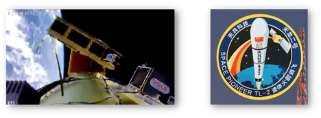
Space Pioneer's Tianlong-2 successfully debuts
2 Apr 2023: Chinese commercial space company Space Pioneer successfully launched the Tianlong-2 rocket from Jiuquan. The company’s first orbital flight performed well, reaching its targeted orbit. This launch makes Tianlong-2 the first Rocket Propellant 1 (a highly refined form of kerosene outwardly similar to jet fuel) based private rocket from China to reach orbit. The rocket lifted Aitaikong Kexue (Jinta), a Sun-synchronous operating satellite. It is a “consumer-grade” scientific satellite built by Hangsheng Satellite and proves technology around innovative space applications and commercial aerospace. Launch Video.
– Tianlong is 35m tall with a diameter of 3.35m. This diameter, which is very common on Chinese rockets, comes down to experience with manufacturing and the maximum diameter allowed to be transported on railroads across the country.
-The rocket can lift up to two metric tons to low Earth orbit (LEO) or up to 1.5 tons to SSO.
-Tianlong-2 placed an 8kg cubesat into a 500km 97.5° SSO. The 4u satellite has two remote sensing cameras, a HAN-based propulsion unit, and an on-orbit wireless charging demonstration.
On-Orbit Updates
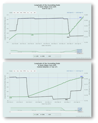
After orbiting in vicinity of AEHF-6 for about 6 weeks, TJS-3 lowered its orbit 57kms and has begun drifting eastward at ~ .8° per day. It has re-located 11.4° east since 24 March 2023.
SJ-17 has re-joined the GEO belt at 115.3°E as of 6 April 2023. SJ-17 decreased its orbit 42.9kms from 25-26 February 2023 and relocated nearly 21° east of its former 94.2° GEO slot. SJ-17 had been at 94.2° since 6 September 2022.
30 Mar 2023: Excellent article from Andrew Jones at SpaceNews. The China Aerospace Science and Industry Corporation (CASIC) told Chinese state media in early March that its first satellite for a constellation of very-low Earth orbit (VLEO) satellites will launch in September.
– VLEO satellites orbit at altitudes of between 150 to 300km, much lower than most satellites.
– At these lower altitudes satellites require propulsion to counter the relatively rapid orbital decay due to much higher atmospheric drag.
– Operating at these altitudes offers cost and performance incentives in the form of reduced power needs for data transmission, lower-latency data transfer, lower solar power-generation requirements, and higher resolution observation.
– The first CASIC VLEO satellite will seek to demonstrate and verify key technologies including “ultra-low orbit flight technology”, high-resolution ground imaging technology, onboard intelligent processing and data transmission technology, according to the Chinese language Science and Technology Daily.
– Details such as the planned lifetime of the satellites, size of the constellation and launch cadence were not revealed.
– VLEO concepts have emerged in the U.S. and Europe in recent years. American firms Skeyeon, Earth Observant and Albedo have raised money for VLEO satellite plans, while the European Union funded the “Discoverer” research program to investigate deploying Earth observation satellites in much lower altitudes than usual.
– For China, global remote sensing capabilities including higher resolution, more frequent revisits, and faster transmission speeds were noted as key space infrastructure in China’s 14th Five Year Plan, covering the period 2021-2025, according to Science and Technology Daily.
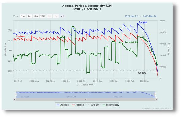
– In a possibly related development, the Tianxing-1 satellite (NORAD 52902), launched on a Kuaizhou-1A rocket in June 2022, reentered the atmosphere March 29, according to U.S. Space Force space tracking.
– The satellite maintained an orbit of around 300 kilometers before its orbit continually decayed over the past month. The satellite was developed by the Chinese Academy of Sciences as part of a plan for the 14th Five-Year Plan. It also carried data acquisition and optoelectronic payloads for CASIC as part of technical verification tests.
30 Mar 2023: Andrew Jones of SpaceNews reports that China will launch a LM-5B rocket from Wenchang with a Yuanzheng-2 second stage for the first time in the second half of 2023. CASC, the China’s main space contractor, stated in early March that the new Long March 5B and upper stage configuration would be used to launch satellites for a LEO satellite network. Watch Guowang background Video.
– China is developing plans to deploy a 13,000-satellite low Earth orbit (LEO) broadband megaconstellation, sometimes referred to as “Guowang,” or national network, to rival Starlink and other Western ventures.
-The China Academy of Space Technology (CAST), a major subsidiary of CASC, and the Innovation Academy for Microsatellites (IAMCAS) under the Chinese Academy of Sciences, are understood to be two entities contracted to manufacture satellites for Guowang.
-IAMCAS is expected to deliver its first 30 satellites for the project by the end of the year. Other and potentially commercial setups could also be involved in the project.
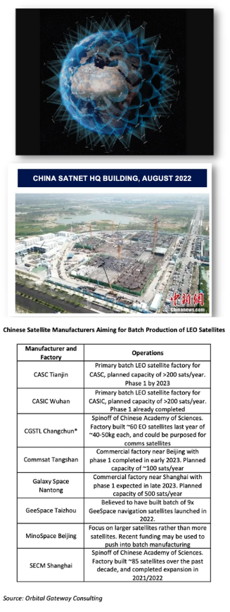
-China greatly increased its small satellite manufacturing capacity in recent years, with a number of entities each capable of producing hundreds of satellites per year. Other actors include GalaxySpace and the state-owned China Aerospace Science and Industry Corporation (CASIC). The former launched six LEO communications test satellites last year.
-CASC’s main rocket-making arm is meanwhile preparing the Long March 5B rocket for a “high-density launch stage to meet the country’s needs for large-scale and rapid access to space.”
-The Long March 5B rocket was earlier used to send the country’s three modules directly into orbit to construct the Tiangong space station. The upper stage would instead allow for multiple satellites to be injected into various orbits.
-The earlier launches saw the 30m-long, roughly 23-ton dry mass first stages make high-profile, uncontrolled reentries after reaching orbital velocity. It is possible but unknown if the use of YZ-2 upper stage will allow for the first stage to remain suborbital land within a targeted drop zone.
-A number of Chinese commercial launch companies have meanwhile stated their aim to secure contracts to launch satellites for the Guowang project. This has apparently been reflected in newer companies looking to build medium and large launch vehicles earlier in their development.
29 Jun 2023: China delivered a set of satellites to Egypt as part of a program to develop Egypt’s capacity to assemble, integrate and test satellites.
-China delivered two satellite prototypes and one flight model to Egypt in March. The Egyptian Space Agency then carried out final assembly and testing at their Satellite Assembly, Integration and Test Center (AITC).
-The MisrSat II Satellite project began in 2019 when Beijing and Cairo signed a $72M grant for Egypt’s space program. It was the third grant provided by China to Egypt for a satellite project. Both countries initially signed a grant of $23M in 2016, and a second grant worth $45M in 2018.
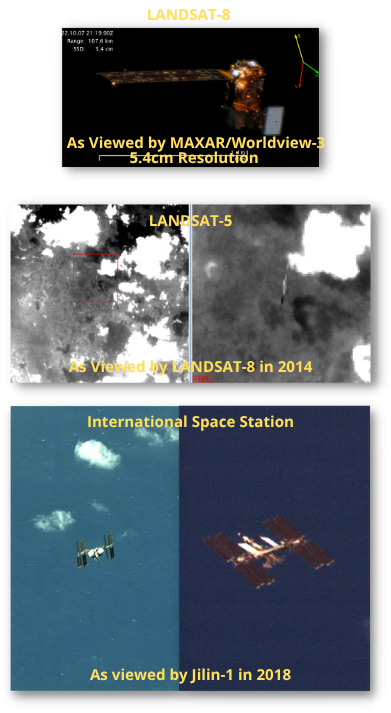
30 Mar 2023: Maxar’s WorldView-3 satellite captured high resolution imagery of LANDAST-8 in LEO. The imagery resolution varied based on the distance between the 2 objects, but was as high as 4.6cms at closest approach (91.4kms). Imaging LEO satellites would immediately yield new information regarding mission and capabilities…commercial imaging of LEO satellites would likely be unclassified and therefore sharable with allies and partners.
–Information in the upper-left-hand corner of the images indicates they were in fact taken on 7 Oct 2022.
-Landsat 8 was initially 129.9km from WorldView-3, other images were collected from ranges as close as 91.4km.
– LANDSAT’s distinctive bus can be seen glowing orange alongside its 9 × 0.4m deployable solar array to the left.
– The gray rectangular-shaped object to the right of the satellite is a Thermal Infrared Sensor (TIRS) used to capture thermal images.
– The other part of Landsat 8’s payload, the Operational Land Imager (OLI), captures images in the visible, near-infrared, and short-wave infrared portions of the electromagnetic spectrum.
– Maxar is in discussions with the U.S. Space Force and other agencies that could use this data to identify potential threats and monitor suspicious activity in space.
– This type of imagery also would support space traffic management and spaceflight safety in the increasingly congested lower orbits where there will be tens of thousands of satellites in the not too distant future.
– The company’s WorldView satellites would collect high-resolution images of other spacecraft and send them to the Space Force’s data repository known as the unified data library. This data library also will support the civilian space traffic management system being developed by the Office of Space Commerce.
Editor’s Note: there are other companies and countries developing these commercial capabilities, the days of relying purely on orbital analysis and curt press releases are numbered!