issue 74 | 4 jun 2023
The integrity flash
Analysis of Developments in the Space Domain
in this issue
Russia Launches New Imaging Satellite
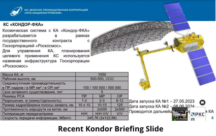
26 May 2023: Russia launched a new SAR imaging satellite, the Kondor-FKA n°1,from Vostochny Cosmodrome. The Kondor satellites are a series of Earth observation satellites providing reconnaissance services for the Russian military. Launch Video & Soyuz Stacking Video.
– Kondor-FKA n°1 has been given the name Cosmos 2569 and is in a 508x506km sun-synchronous orbit.
– The Kondor satellites feature an S-band synthetic aperture radar (SAR), conducting both continuous swath surveys and detailed spot surveys of Earth’s surface. The width of the SAR’s swath is 10km with a ground resolution of 1-2m in spotlight mode, 1-3m in strip-map mode, and 5-30m while in ScanSAR mode.
– Kondor-FKA will assist Russia in its war against Ukraine. It makes two passes over Ukraine each day and can make radar images of “Ukrainian military objects” with a resolution of 1m.
– Officially, Kondor-FKA is a civilian satellite ordered by Roskosmos, but in the current circumstances it may well become a dual-purpose satellite.
– The only other positively identified Russian radar satellite currently in orbit is Kosmos-2550 (Pion-NKS), but this is mainly intended to provide targeting data for anti-ship missiles. However, it is quite likely that Kosmos-2553 (Neitron) is also a military radar satellite. Like Kondor-FKA, this is a product of NPO Mashinostroyeniya and appears to use the Kondor bus. In fact, it may have been used to test various new systems flown aboard Kondor-FKA. Kosmos-2553 does circle the globe in a significantly higher orbit (about 2000 km) inclined 67° to the equator.

India Launches Next Gen Navigation Satellite
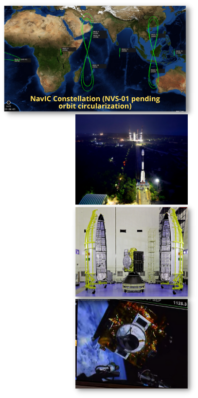
28 May 2023: India launched a NVS-01 navigation satellite using a Geosynchronous Satellite Launch Vehicle (GSLV) Mk.11 rocket from the Satish Dhawan Space Centre. NVS-01 is the first of India’s second-generation NavIC satellites and is equipped with new Indian-developed atomic clocks. Launch Video. Satellite Deployment Video.
– The Navigation with Indian Constellation (NavIC), system is a regional satellite navigation network developed by the Indian Space Research Organisation (ISRO). Also known as the Indian Regional Navigation Satellite System (IRNSS), the system’s first generation consists of seven satellites in geosynchronous orbit – although a total of nine spacecraft have been launched, including replacements.
– IRNSS-1A, the first satellite in the series,
was launched in Jul 2013, with the constellation reaching its full complement following the launch of IRNSS-1G in Apr 2016. After three years in orbit, the atomic clocks aboard IRNSS-1A began to develop faults, and IRNSS-1H was launched as a replacement in Augt 2017. This did not reach orbit after the payload fairing of its carrier rocket failed to separate, so IRNSS-1I was deployed instead in Apr 2018, becoming the final first-generation IRNSS satellite to launch.
– ISRO has confirmed the failure of several other clocks across other satellites in the fleet. ISRO’s annual report for 2020-21 noted that the IRNSS-1G satellite had also been moved to a secondary role, but did not identify the reason for this. NVS-01 is expected to take IRNSS-1G’s slot in the constellation.
-Accurate timekeeping provided by atomic clocks is vital to operating navigation satellites, as the signals they broadcast contain timestamps. Receivers use these timestamps, and the knowledge that radio signals propagate at the speed of light, to calculate distance to the satellites and triangulate their position based on the signals and relative positions of multiple satellites.
-NVS-01 is also over 900kg heavier than the first-generation satellites and incorporates other enhancements to expand the capabilities of the NavIC constellation. These include broadcast of a new L1 signal, in addition to the L5 and S-band signals broadcast by the existing satellites, which will improve interoperability with other satellite navigation systems such as the US Global Positioning System (GPS) network.
Report: Large Constellations of Low-Altitude Satellites
May 2023: The US Congressional Budget Office (CBO) published a primer on the increasing use of LEO satellite constellations. Great article for those new to space operations as well as a look at the capability and economic factors driving pLEO constellation development/deployment. I found the primer to be a great info-graphic resource…some favorites below (all are hyperlinks).

On Orbit Updates: Tianhui 2-02A & 02B
– China maneuvered Tianhui 2-02A & 02B, two Synthetic Aperture Radar (SAR) imaging satellites, to within 1km of one another.
-Orbital graphs indicate Tianhui 2-02A maneuvered into proximity with 2-02B, after making multiple altitude changes whereas the SMA for 2-02B remained unchanged.
– Tianhui 2-02A and 2-02B launched on 18 Aug 2021 on a Long March 4B from Taiyuan.
– The Tianhui 2 (“Sky drawing”) series are a quasi-secretive group of Earth observation satellites designed to monitor Earth’s surface. They are constructed by Dong Feng Hong and operated by the People’s Liberation Army.
– The satellites are in a sun synchronous orbit as is typical for imaging satellites.
– This activity is rare for these types of satellites.
– One possible explanation is the two satellites will work cooperatively. As an example, China recently launched 4 SAR satellites that will fly in formation. The PIESAT (also known as Hongtu-1 01A-D) spacecraft are X-band synthetic-aperture radar satellites with a resolution of 0.5-5m.
-The four PIESAT satellites form a single module. The module consists of one main satellite and three sub-satellites oriented around the main module. The main satellite will act as the transmitter, while the three passive satellites are the receivers.
-As of 3 Jun the PIESAT satellites have not maneuvered into formation.
-Other potential rationale is a secondary mission or using one satellite to image the other (unknown if this is a possibility with a SAR imager).
-Based on 3 Jun orbital parameters, the satellites will remain .5km from one another with a relative velocity of .001km/sec for the next several days.

On Orbit Updates: Chuangxin 16A & 16B
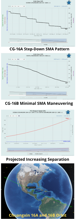
– China maneuvered its experimental Chuangxin 16A & 16B satellites to rendezvous with one another in late-May to early-Jun.
– Based on 27 May orbital parameters, the satellites were to close within .002km and relative speed .002km/sec.
-On/about 30 May, Chuangxin 16A altered its SMA slightly (~.1km) and, as a result, the two satellites began separating.
-As of 3 Jun the two satellites are 62km apart with a relative velocity of .07km/sec.
– China launched Chuangxin 16A & 16B on 23 Aug 2022 China, using a Kuaizhou-1A from Xichang. Both spacecraft were developed by the Chinese Academy of Sciences (CAS). Launch Video.
– The spacecraft will reportedly be used for verification of new technologies. Few details were publicly released on the Chuangxin-16 and there was some confusion over the number of satellites carried to orbit (either 1 or 2).
– The Chuangxin (translated as “innovation”) payload is meant for technology research…one possible demonstration would be automated undocking, rendezvous, and re-docking of these two satellites.
– Both satellites are in a 29° inclined orbit and it appears that Chuangxin-16A has routinely decreased its SMA since Jan 2023. Chuangxin-16B does not appear to have changed its SMA or other parameters since being placed into orbit in Aug 2022.
-Conducting proximity operations between two technical verification satellites, while unusual, is not unexpected and appears to be consistent with stated mission purposes (vague as they were).
On Orbit Updates: TJS-3
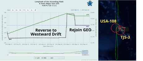
Between 13-21 May 2023, TJS-3 altered its SMA to reverse its its eastward drift. TJS-3 remained ~56kms above GEO and drifted westward from 177.9° to 173.0°E. On 20-21 May, TJS-3 decreased its SMA to rejoin the GEO belt and has remained at 173.0°E.
TJS-3 may be making a return visit
to USA 108, a UHF Follow On military comsat. USA 108 was launched in 1995, but appears to be maintaining its orbit.
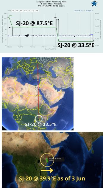
On Orbit Updates: On the Road Again, SJ-20 heads East
-Between 25-26 May 2023, China’s SJ-20, believed to be an experimental communications satellite, decreased its orbit ~55km, initiating an eastward drift.
– China launched the SJ-20 on 27 Dec 2019 on the massive CZ-5 launch vehicle. SJ-20 is China’s largest communications satellite (8,000+kg) and uses the DFH-5 bus.
– In Aug 2020, USA 271, one of the US Geosynchronous Space Situational Awareness Program (GSAPP) satellites, approached SJ-20. However, the Chinese clearly detected the US satellite and rapidly moved SJ-20 away. Watch Video.
–Almost exactly one year ago, SJ-20 relocated from 87.5°E to China’s ITU reserved 33.5°E.
– Interestingly 33.5°E is due south of Ukraine, between Kyiv and Kharkiv.
-Given the experimental nature of SJ-20, it is unlikely it was providing any communications support to any Russian combatants.
-China may have stationed SJ-20 over an active conflict to test other capabilities.
-SJ-20 subsequently raised its orbit ~20km on 3 Jun, slowing its drift. 3 Jun 2023 observations placed SJ-20 at 39.9°E.