
issue 62 | 4 dec 2022
The integrity flash
Analysis of Developments in the Space Domain
in this issue
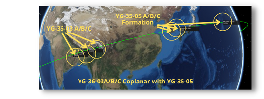
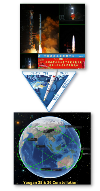
27 Nov 2022: China launched it’s third set of Yaogan-36 triplets from Xichang. As with Yaogan 36-01 and 02 the launched used the Long March 2D space launch vehicles. China has launched the Yaogan-36 satellites to be co-planar with previously launched Yaogan 35 satellites which also fly in a lead-trail-trail formation. The capabilities of the Yaogan 35
and Yaogan 36 constellations are not yet known. Launch Video.
-All Yaogan 35 and Yaogan 36 satellites operate at ~500km and 35° inclination. This provides optimal coverage for the Taiwan Strait and the South China Sea.
– Other Yaogan ELINT satellites have flown to 35° inclinations have typically flown at altitudes on the order of 500 or 600km
– Yaogan 36-03 is co-planar with Yaogan 35-05 satellites which launched on 6 Sep 22. Yaogan 36-01 is co-planar with Yaogan 35-01, and Yaogan 36-02 is co-planar with Yaogan 35-02.
-YG-36-03 satellites will likely maneuver into the traditional 1 lead 2 trail formation like the YG-35 and YG-36 triplets.
– For both Yaogan 35 and 36 the A and B payloads were developed by CASC, while payload C was developed by SAST. The exact purpose and mass of the payload remain unknown. The exact purpose of these triplet missions is not known at
this point.
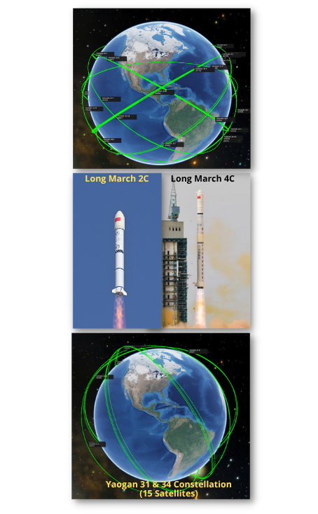
In the past year China deployed 15 Yaogan-35 and 9 Yaogan-36 satellites (see previous article). This is not their first rapid deployment of space capabilities. The Yaogan 30 and 31 constellations were also established in short order (at least in terms of space timelines). Below is a list of launches with locations, launch vehicles and dates.
Yaogan 30 (30 Total Satellites):
– The Yaogan-30 satellites and constellation are suspected to support military intelligence like SIGINT, similar to the American Naval Ocean Surveillance System, known as NOSS, used by the U.S. Navy. All are in a 600km orbit at 35° inclination.
-All were launched three at a time using a Long March 2C from the Xichang Launch Center.
-2017: 3 Launches (9 Satellites)
-2018: 1 Launch (3 Satellites)
-2019: 1 Launch (3 Satellites)
-2020: 2 Launches (6 Satellites)
-2021: 3 Launches (9 Satellites)
From 1st triplet launch (29 Sep 2017) to 10th launch (19 Jul 2021): 3.8 years
Yaogan 31/34 (15 Total Satellites):
-Yaogan-31 satellites are believed to be maritime reconnaissance satellites for tracking foreign naval movements. Using 3 satellites in formation allows them to intercept radio signals from the ground and calculate/track the position of warships while also studying their activity based on their radio emissions. All satellites are orbiting at ~680 miles (1,100km), with 63.4° inclination. Yaogan-34 satellites seem to be optical remote sensing satellites, likely used as a military reconnaissance satellites. They are co-planar with Yaogan-31 triplets, with the Yaogan-31 formation leading and Yaogan-34 in trail.
-All were YG-31s were launched in triplets, the YG-34s were launched alone. All YG-31 and 34 launches occurred at the Jiuquan Launch Center and used the Long March 4C.
-2018: 1 Launch (3 YG-31 Satellites)
-2021: 4 Launches (9 YG-31 and 1 YG-34)
-2022: 2 Launches (2 YG-34)
From first launch (4 Oct 2018) to most recent (15 Nov 2022): 4.1 years
Number of Yaogan Launches 2000-2016 = 48 avg 2.8/year
Number of Yaogan Launches 2017-2020 = 27 avg 6.75/year
Number of Yaogan Launches 2021-2022 = 48 avg 24/year (and there’s a month left!)
China SpacePlane Update: Play Time!
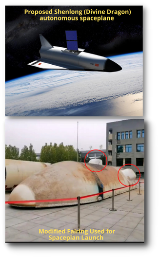
Nov 2022: China’s Space Plane (2022-093A) which launched this summer appears to be maneuvering with its mysterious partner satellite (2022-093J or “object J”). At one point the two objects were within 100m of one another.
– Mid-Aug: spaceplane increased its altitude from 346x593km to 351x595km.
– Oct 23: the spaceplane raised its perigee to create a ~600km circular orbit
– Oct 24 – 31: Object J released and performed station-keeping to remain close to the spaceplane. Object J first tracked in SpaceTrack.org on 31 Oct.
– Nov 2 – Nov 7: spaceplane & companion drifted apart by ~8km along the orbit but orbit heights stayed similar Separation ‘event’ late Nov 7 pushed rate up to 10 km/day but still with near-identical orbits
– Nov 11: spaceplane separating from Object J at ~10 km/day
– Nov 19: Spaceplane and Object J drifted to ~100km separation, spaceplane thruster firing started chase of other Object J.
– Nov 20: spaceplane caught up & matched Object J’s orbit and pair began station-keeping at ~1km separation.
– Nov 23: spaceplane settled in fixed position 5km behind Object J
– Nov 24: 1200 UTC the spaceplane was 2 km behind, closing slowly
– 26 Nov: Spaceplane moved to within 100m of Object J. Given the +/- in the data, they could have been orbiting side by side or even joined together.
This is the second test flight of the Chinese spaceplane. The first occurred in Sept 2020 and only lasted 2 days. The first flight also released a separate payload…a Banxing inspector satellite. As of 4 Dec the spaceplane has been in orbit 122 days.
28 Nov 2022: China released its pathway for robotic and crewed lunar and deep space exploration, with a number of missions building towards a permanent moon base.
– China will send landers, orbiters, relay satellites and test key technologies needed to begin construction of China’s International Lunar Research Station (ILRS) in the 2030s.
-China is now planning a short-term crewed lunar landing mission before the end of the decade. The mission would use two launches of an under-development new generation crew launch vehicle to send three astronauts to the moon, seeing two of them set down on the surface for around six hours. The requisite spacecraft and lunar lander are in development.
-The next lunar mission is Chang’e-6 that will attempt to collect up to two kilograms of material from the South Pole-Aitken Basin on the lunar far side in 2026.
-China will also launch a new lunar relay satellite to facilitate communications with missions targeting the vicinity of the south pole of the moon.
-As has become the pattern, YG-36(04) is plane matched with a YG-35 triplet, this time YG-35(03).
– Yaogan 36-03 is co-planar with Yaogan 35-05 satellites which launched on 6 Sep 22. Yaogan 36-01 is co-planar with Yaogan 35-01, and Yaogan 36-02 is co-planar with Yaogan 35-02.
-Two of the three satellites YG-36(04) satellites were developed by the Aerospace Dongfanghong Satellite Co., Ltd., with the third provided by the Shanghai Academy of Spaceflight Technology (SAST), both of which operate under CASC. (This is true for all YG-35 & 36 triplets).
– Few details about the satellites were disclosed by China’s government-owned media. The country’s Xinhua news agency said the satellites will be mainly used to test “new Earth-observation technology.”
– Looking at similar orbits and formations, between 2018 and 2020 China launched 8 XJS satellites with similar orbital parameters. All are 35° inclined and between 460-475km in altitude.
– Yaogan-35/36 satellites may operate in lead-trail configuration, with the lead satellite potentially cueing the two trailing vehicles.
29 Nov 2022: The Department of Defense (DoD) released its annual report to Congress detailing the latest developments and assessments of Chinese military power. Here’s a link to the 2 page cheat sheet…to read/skim the full 196 page report <you should> find it HERE.
– The report calls the Peoples’ Republic of
China “the most consequential and systemic challenge to our national security and to a free and open international system.”
-An important element of China’s strategy “is a determined pursuit to amass and expand its national power to transform — at least — aspects of the international system to make it more favorable to the PRC’s

political system and its national interests.”
-There is a trend of more coercive military behavior by China. “We’ve seen more coercive and aggressive actions in the Indo-Pacific region, including some of which we would highlight as being dangerous.” This includes PLA ships and aircraft demonstrating unsafe and unprofessional behavior.
-Another element of China’s strategy is strengthening the PLA’s strategic deterrence capabilities. China defines this element broadly to include nuclear, space, cyber, electronic warfare, counterspace capabilities and more.
-“The PLA refers to ‘systems destruction warfare’ as the next way of war,” the official said. “They’ve also begun discussing a new operational concept for them: what they call a core operational concept … called multi-domain precision warfare.”
-China “wants its economic and political and social and military and security developments to be coordinated and mutually reinforcing, and to support the ambitious objectives that Xi Jinping has laid out for national rejuvenation by 2049.”
-“As an outcome of the 20th Party Congress [in October], Beijing is focusing on intensifying and accelerating the PLA’s modernization goals over the next five years, including strengthening what they refer to as its system of strategic deterrence.”
Regarding China’s Space Capabilities:
-The People’s Liberation Army (PLA) views space superiority, the ability to control the space-enabled information sphere and to deny adversaries their own space-based information gathering and communication capabilities, as critical components in conducting modern “informatized warfare.”
– The PLA continues to invest in improving its capabilities in space-based intelligence, surveillance, and reconnaissance (ISR), satellite communication, satellite navigation, and meteorology, as well as human spaceflight and robotic space exploration.
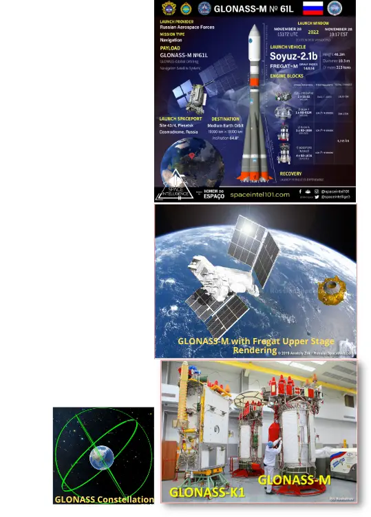
28 Nov 2022: Russia launched a Soyuz-2.1b from the Plesetsk Cosmodrome, carrying the final GLONASS-M satellite to orbit, designated Kosmos-2564. The GLONASS (Globalnaya Navigationnaya Sputnikovaya Sistema, or Global Orbiting Navigation Satellite System) is a Russian radio-based satellite navigation system comparable to the American GPS (Global Positioning System) satellites, the European Galileo constellation, or the Chinese BeiDou system. Launch Video.
– The GLONASS M-61 satellite was one of three last satellites relying on a pressurized platform to house onboard avionics, before more advanced spacecraft fully equipped with systems capable of operating in the vacuum of space took over the composition of the GLONASS network.
– GLONASS-M provided a backup to the new-generation GLONASS-K series, in case there was a problem with their production, in particular due to ban on the supply of space-rated electronics to Russia.
– During GLONASS missions, the Fregat-M upper stage conducts three orbital maneuvers to deliver the spacecraft to its operational circular orbit more than 19,000 kilometers above the Earth’s surface.
– GLONASS satellite orbits are arrayed in three planes, separated from one another in right ascension of ascending node by 120 degrees, with eight satellites in each plane. The satellites within a plane are equally spaced, separated in argument of latitude by 45 degrees. Satellites in adjoining planes are shifted in argument of latitude by 15 degrees.
– The satellites are placed into nominally circular orbits with a target inclination of 64.8 degrees and semi-major axis of approximately 25,510 km, giving them an orbital period of about 675.8 minutes. These satellites have ground tracks that repeat every 17 orbits or eight sidereal days.
– GLONASS satellites provide 100m accuracy with their C/A (deliberately degraded) signals and 10-20m accuracy with their P (military) signals.
-With this launch there are now 26 active GLONASS satellites on orbit. 23 are GLONASS-M with the more durable GLONASS-K making up the other 3.
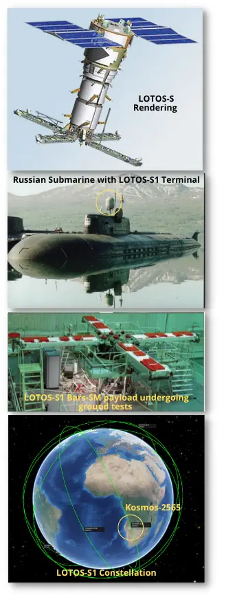
30 Nov 2022: Only 2 days following the GLONASS launch another Soyuz-2.b launched from the Plesetsk Cosmodrome. Onboard was likely a Lotos-S1 No. 6 electronic intelligence satellite for the Russian military. This satellite now goes by the name Kosmos-2565. Launch Video.
– Lotos-S1 No. 6 was initially cataloged in a 240 by 900 km orbit, inclined 67.1°. This is a consistent transfer orbit with the other Lotos-S1 satellites.
– All of the Lotos-S satellites are in a ~900km circular orbit and inclined at 67.1°.
-Lotos-S1 No. 6 joins a network of six other Lotos satellites, one of which is a developmental version of the spacecraft launched in 2009 named Lotos-S.
– The first launch of an operational version, Lotos-S1, occurred in Dec 2012, and the remaining two satellites in the series will be operational variants ordered by the Russian Ministry of Defense in Sep 2017.
– These are typical orbits for ELINT satellites, which are mainly used to pick up radar transmissions. For instance, the US naval ocean surveillance satellites are at 1000km & 63,4° and the French CERES satellites at 670km & 75°.
– Lotos-S is capable of intercepting radio signals helping to locate, identify, and target various military vehicles and installations.
– Special terminals installed on Russian war ships were reported to be capable of downlinking real-time data directly from the Liana network for the purpose of weapon guidance.
– The Lotos satellites have limited, if any, COMINT capability (reception of voice communications). Better suited for COMINT are Molniya-type orbits and geostationary orbit. COMINT is probably the main purpose of the Repei-V and Repei-S satellites, which are yet to be launched.
– Unofficial sources indicate that, despite their high cost, the initial Lotos satellites in the series reportedly provided no advantages over Tselina-2, the last of which launched in 2007.
– Lotus-S and PION make up the 2 satellites in Russia’s Liana ISR constellation. The two original Lotus satellites do not appear to be maintaining their orbits, and a Russian industry source said that only Lotos-S1 No. 804 (launched in 2018) satellite was operational when Kosmos-2549 launched. PION-NKS launched Jun 2021.
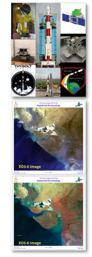
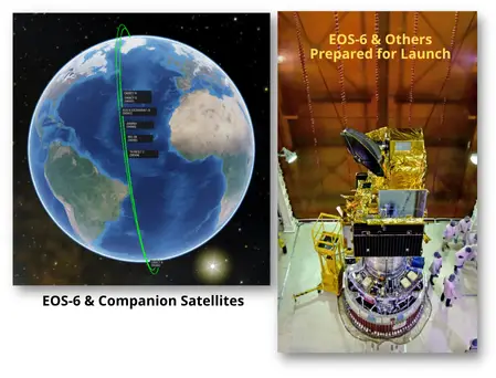
26 Nov 2022: India launched a new ocean monitoring satellite and 9 other smaller satellites using its Polar Satellite Launch Vehicle (PSLV) rocket from Satish Dhawan Space Centre. The the EOS-06 spacecraft is now in low Earth orbit. Launch Video.
– EOS-06, also known as Oceansat-3, mission is to monitor the color of the ocean surface and to collect data on wind speed and direction over the surface.
– Oceansat-3 is cataloged in a 731 x 747 km x 98.4 deg sun-sync orbit. Seven more objects (1 remaining) were also cataloged in the lower 500 x 520km orbit where the secondary payloads were deployed.
-EOS-06 has a mass of 1,117kg and the satellite is equipped with four payloads. Its primary sensor is the Ocean Color Monitor 3 (OCM-3), a successor to the OCM-2 instrument on Oceansat-2. OCM-3 is a 13-band multispectral imaging system capable of recording images of the Earth at a resolution of 360 meters across 10 visible-light bands, with a lower resolution of around 1.4km available across the three additional bands in the near-infrared.
-There were eight secondary payloads — smaller satellites hitching a ride aboard the same rocket. The largest of these is Indian Nanosatellite 2B (INS-2B), with a mass of 18.28 kilograms.
– PSLV is India’s workhorse, having flown 56 missions. PSLV is a four-stage rocket using a combination of solid and liquid-propellant stages, it can fly in several different configurations to meet mission requirements.
-PSLV’s 4th stage, the PS4 or L-2-5, is liquid-fueled and re-startable, allowing for make multiple burns for precise orbit insertion or deliver payloads to different orbits.
Jack's Astro Corner: Video Edition!
In this Astro Corner I’m going to share with you 3 YouTube videos I made in the April-May 2020 timeframe. In my role at the National Space Defense Center I’d be given 10 minutes at the weekly “all-hands” call and share a short astro lesson. I had fun giving those “speed” lessons in astro. The folks on watch seemed to enjoy them too. Well, the health crisis back then prevented those gatherings, so I decided to give YouTube’ing a try and make short astro YouTube videos. In this Astro Corner you’ll have the chance to see 3 of these creations of mine.
The topic of the videos is RELATIVE MOTION. That is the stuff that’s behind all this Rendezvous and Proximity Operations (RPO) happening out there. It’s basically down to perspective, that is how you look at the motion of one satellite relative to another. We are so used to looking at orbits from an inertial perspective, but when two spacecraft are close and hanging out with each other it looks different when examined from one of the spacecraft. So, what I ask is you give each YouTube a viewing, they are about 12 minutes each, and really focus on the relative coordinate frame (called the RIC frame) and then how a single Delta-V (thruster firing) in a particular direction can induce relative motion. I fix the RIC frame on the Target spacecraft, the one that’s not maneuvering and the Chaser’s motion is noted.
Here’s the first 2 of 3 YouTube’s…enjoy them.
Video 1: Relative Motion-Natural (1 of 2)
Video 2: Relative Coordinate Frame (the RIC frame) and Radial maneuver motion (2 of 2)
The last YouTube explains another option and that is Forced Motion where we can hurry along the Chasers path around the Target.
Video 3: Relative Coordinate Frame (RIC), brief natural motion review and FORCED motion circumnavigation
You must be logged in to post a comment.