issue 40 | 30 jan 2022
The integrity flash
Analysis of Developments in the Space Domain
in this issue
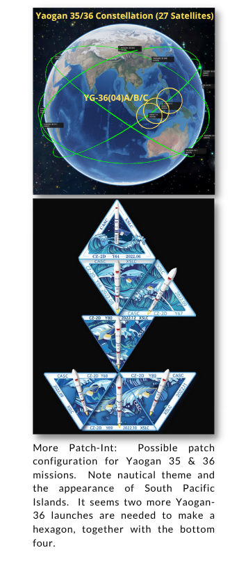
Movin' on Up: SJ-21 Super-synchs Beidou-2 G2
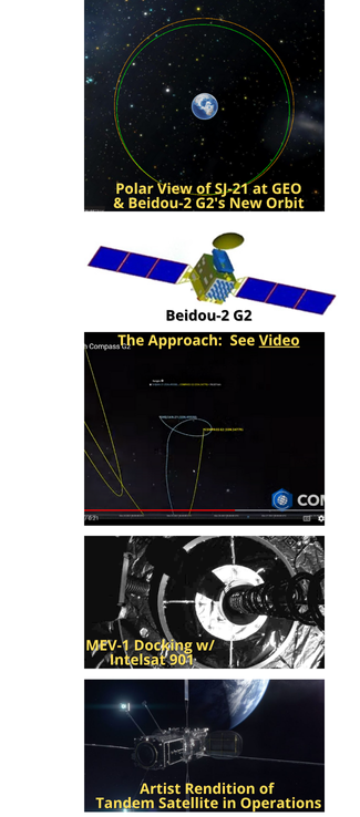
1 Jan 2022: Four months after launching on 23 Oct, Shijian-21 (SJ-21) docked with a defunct Chinese satellite to drastically alter its geostationary orbit, demonstrating capabilities only previously exhibited by the United States. See Videos Event, Tracking of Event
– Shijian-21 docked with the defunct Beidou-2 G2 navigation satellite and towed it above the geostationary belt.
– SJ-21 approached the defunct Beidou-2 G2 navigation satellite in December, matching its orbit, rendezvousing with, and eventually docking with the spacecraft.
– SJ-21 performed a large burn on 22 Jan, taking the Beidou-2 G2 satellite 3,000km above the GEO belt.
– Tracking SJ-21 was not a trivial event. SJ-21 went “missing” from its orbital slot for a few hours, after performing what are known as “close proximity operations,” moving closer to Beidou-2 G2. The “gap” in observations was the result of the timing of the docking maneuver during daytime — when telescopes cannot image. ExoAnalytics tracked it down after it performed “a large maneuver” pulling the dead satellite out of GEO.
– The docking and subsequent engine burn — which was unusually large, taking it beyond the usual “graveyard” orbit of 300 km above GEO — has effectively moved Beidou-2 G2 out of harm’s way.
– SJ-21 undocked from Beidou-2 G2 on 26 Jan, leaving the defunct satellite in a disposal orbit. SJ-21 has returned to GEO.
– Beidou-2 G2 failed in orbit after its 2009 launch and drifting since 2010. Some believe it may have partially fragmented.
– Little is known about SJ-21. China unveiled a servicing satellite model by the Shanghai Academy of Spaceflight Technology (SAST) at an airshow in September 2021, described as a space fuel tanker. A model of the spacecraft featured robotic arms which could be used for attaching to another spacecraft.
– On 1 Nov 2021 (1 week after launch), SPCS cataloged a new object alongside SJ-21 with the international designator 2021-094C. The object was used for early RPO and inspection tests before SJ-21 targeted the Beidou satellite, COMSPOC tracking shows. See Video.
– SJ-21’s mission appears to be similar to that of the two Northrup Grumman Mission Extension Vehicles (MEV-1 and MEV-2).
China describes SJ-21 as a space debris mitigation satellite. Still, no details of the satellite nor its planned objectives were released by its developer, the state-owned China Aerospace Science and Technology Corporation (CASC), following its successful launch. The classified nature of the mission suggests it may have at least some military stakeholders or objectives.
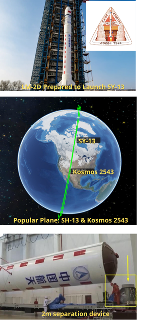
17 Jan 2022: China launched the classified Shiyan-13 (SY-13) payload from the Taiyuan Satellite Launch Center aboard a Long March 2D. The LM-2D inserted SY-13 into an unusual 357 by 1,297-kilometer orbit inclined by 98.7 degrees. Launch Video.
– China release no information regarding the mission or capabilities of SY-13. The CASC press release stated: “The Experiment No. 13 satellite is primarily used to conduct space environment sensing and related technology experiments.”
– Chinese state media also provided no information regarding the payloads or uses of Shiyan-13.
– China did place SH-13 in an orbital plane near the USA-245 (believed to be the last of the Block 4 KH-11 optical reconnaissance satellites).
– This orbital plane is also shared with Kosmos 2542 and Kosmos 2543 which are believed to be part of Russia’s Nivelir co-orbital ASAT program. Launched in 2019 Both Kosmos 2542 and 2543 have maneuvered to place themselves in positions to observe USA-245.
– Shiyan are understood to be a series of test satellites, with first launched in 2004. Shiyan satellite numbers are often non-sequential and have been developed by a range of entities, including the China Academy of Space Technology (CAST), CAS and the Harbin Institute of Technology (HIT).
– China currently has more than 10 Shiyan satellites in Sun-synchronous and GEO orbits. Shiyan-10, launched in Sep 2021, remains in a GEO transfer orbit (1,046 by 40,152 km inclined by 51 degrees) following an apparent anomaly affecting the satellite after launch.
– CASC did reveal that a two-meter-diameter satellite-rocket separation device was used the first time with the Long March 2D due to special requirements of the satellite interface
– The Long March 2D series are scheduled to launch more than 15 times during the year, according to CASC. The rocket can launch from all three of China’s inland national launch centers at Jiuquan, Taiyuan, and Xichang. There were 6 LM-2D launches in 2021.

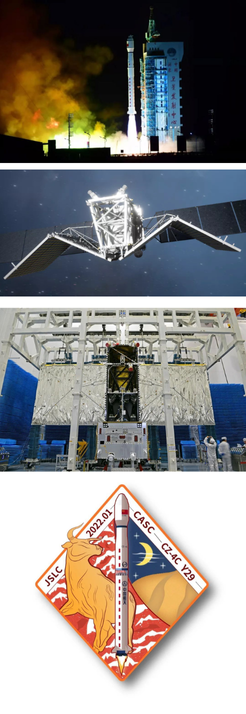
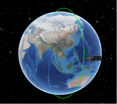
25 Jan 2022: China launched the first of a pair of radar satellites that will provide geological data following earthquakes and landslides. A Long March 4C lifted off from Jiuquan Satellite Launch Center in the Gobi Desert. The LM-4C carried the L-SAR 01A satellite, equipped with L-band synthetic aperture radar (SAR), which will be used to monitor the geological environment, landslides and earthquakes. It is in a near-polar orbit of 98 degrees with an altitude of about 373 miles (600 kilometers). See Video.
– L-SAR 01A is the first of a group of two satellites. L-SAR 01B will launch at the end of February, according to the China National Space Administration.
– The satellites will fly in formation and provide geological insights after seismic events such as earthquakes, volcanic activity and landslides and aid relief efforts. The satellites will also conduct large-scale topographic surveys.
– The satellite is equipped with an L-band and multi-channel synthetic aperture radar (SAR) payload. It is a civilian satellite that will use a 33 square meter array. At 3.2 tons it is currently the largest Chinese SAR satellite in orbit.
– This is comparable to the Argentinian SAOCOM satellites which are also equipped with L-band and a SAR to monitor environmental disasters.
– L-band makes it easier to monitor the Earth’s surface with the ability to penetrate clouds, rain, and vegetation. It operates in a frequency range of 1-2 GHz.
28 Jan 2022: China released a new white paper outlining the centrality of space to the country’s “overall national strategy” as well as major plans for the years ahead. The whitepaper highlighted China’s goals to develop its space transportation capabilities, test new technologies, embark on exploration missions, modernize space governance, enhance innovation and boost international cooperation. See Full Text or watch the (translated) Press Conference.
– The quinquennial white paper document, titled “China’s Space Program: A 2021 Perspective,” was released 28 Jan by the State Council Information Office.
– It notes that the global space industry has entered a “new stage of rapid development and profound transformation,” and outlines activities planned to meet new challenges & build new capabilities.
– Exploration goals for the next five years include the launch of the Chang’e-6 lunar sample-return and the complex Chang’e-7 missions, both to the moon’s south pole. The Chinese are also planing joint asteroid sample-return, comet rendezvous mission, research and development on key technology for the Chang’e-8 lunar base precursor mission, and completing key technological research on Mars sample-return and Jupiter missions.
– Space transportation plans include new-generation crew launch vehicles, high-thrust solid-fuel rockets, and accelerating development of heavy-lift launchers. Research priorities include key technologies for reusable space transport systems, developing new rocket engines, combined cycle propulsion (related to spaceplane projects), and upper stage technologies.
– China aims to strengthen space traffic management; improve its space debris monitoring system, cataloging database and early warning services; conduct in-orbit maintenance of spacecraft; test mission extension vehicles; and undertake space debris mitigation.
– Research into navigation-communications integration, low-orbit augmentation and other key technologies for the “next-generation Beidou” system will also be conducted.
– There is no mention of China’s space-related military capabilities and objectives…strategic initiatives like the Belt and Road are noted a number of times in the text.
– In the next five years China plans on-orbit tests of new space materials, smart self-management of spacecraft, mission extension vehicles, innovative space propulsion, in-orbit servicing, and studying plans for building a near-earth object defense system.
China’s space ambitions far exceed any other space faring nation in range and long-term strategy. This includes incrementally developing space capacity in sequence. First, build space capacity for cost effective launch and access. Second, launch its own permanent space station. Third, create capacity to dominate cislunar space. Fourth – once cislunar is secured – develop the capacity for sustainable presence on the Moon, including in-space manufacturing and mature space-based solar power (SBSP) technology to fuel its lunar base and sustain human presence. Finally, develop capacity for deep space exploration and resource extraction from asteroids.
27 Jan 2022: The COMSPOC noted that USA-270, the US Geostationary Space Situational Awareness Program (GSSAP) 3 satellite, neared a pair of new Chinese technology test satellites, Shiyan-12 (01) and (02), as it drifted East just below the GEO belt. See Video Recreation.
– “As that [USA-270] satellite gets close, and does a maneuver in the vicinity of these two Chinese satellites, within a matter of two days, the Chinese satellites are on the move,” says Jim Cooper, lead for SSA solutions with COMSPOC.
– “China has clearly been monitoring this satellite as it approaches; they’ve seen what the US has done to maneuver, in a way that potentially could impact their satellites. They processed that; they understood it. And they effectively planned and executed a mitigation strategy around that U.S. satellite,” Cooper says, seeing both of these satellites leave the area in synchronicity to get away from that U.S. satellite.
– The closest approach between the U.S. and one of the Chinese satellites was around 73km.
– Such close approaches are not forbidden by existing space norms but indicate a context of growing counter-space activity among major space powers.
China has advanced levels of SSA, evidenced by activity detected during a close encounter of US and Chinese satellites…”we are starting to see these types of scenarios play out more where other countries are approaching and trying to do things around other countries’ satellites. And then we’re seeing those other countries’ satellites react to that situation and do something about it.”
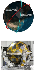
18 Jan 2022: According to China’s National Space Debris Monitor Center, space debris No.49863 from Russian Cosmos 1408 LEO ASAT weapons test had a close encounter (perhaps as near as 14.5m) with China’s Tsinghua Science Satellite (No.46026).
– The small, spherical Tsinghua Science satellite was launched in Aug 2020 on a Long March 2D rocket to make atmospheric density and gravitational field measurements. It is in a 478 by 499-km orbit inclined by 97.4 degrees.
– Russia destroyed the roughly 2,000-kg Russian Cosmos-1408 satellite on 15 Nov with a direct-ascent ASAT missile.
– “The test so far has generated more than 1,500 pieces of trackable orbital debris and will likely generate hundreds of thousands of pieces of smaller orbital debris,” the U.S. Space Command Public Affairs Office stated shortly after the ASAT test.
– China’s Foreign Ministry has declined to comment on Russia’s ASAT test…any response would be complicated by China’s 2007 destructive, debris-creating ASAT test. That test created debris that continues to be a hazard for satellites, the ISS, and China’s crewed station.
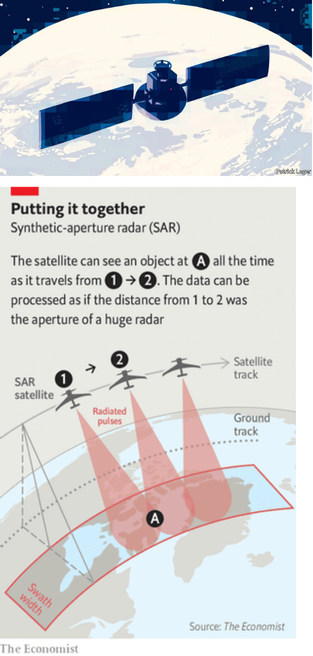
29 Jan 2022: The Economist published an article about the basics of how Synthetic Aperture Radar (SAR) imagery works and its potential benefits and other consequences.
– Orbiting radars illuminate the surface using wavelengths hundreds of thousands of times longer than those of visible light.
– These wavelengths pass easily through clouds,
fog/smog, and camouflage netting before bouncing back to space.
– Advances in electronics, spacecraft engineering, and on-orbit computation mean it’s possible to put SAR systems with resolutions of a few meters or less on small satellites at a reasonable price.
– The ability to see through poor weather, day or night, lends itself to tracking things that change over time. A military build-up (similar to that on the Ukraine border) is the perfect target; the imagery may not be sharp enough to identify specific types of tanks, but is good enough to count and detect overall changes.
– Capella has six satellites in orbit that can check any point on the planet every six hours. The company’s planned 40-satellite constellation should get that revisit time down to no more than 15 minutes.
– The time it takes to get the information down from space and into the hands of those who need it is also falling quickly, as big data companies like Amazon Web Services pile into the market and expand the number of ground stations.
– In five years it will be possible to request an image, communicate with the satellite, and receive the product in minutes.
– SAR images covering 16 square kms at 1m resolution sell for $500 under a Creative Commons’ license, letting buyers do as they please with the product. The current price of an optical image of equivalent granularity would be around six times as much, and sold under restrictive conditions.
The capabilities of SAR are just one example, albeit a dramatic one, of the sort of progress being made with all sorts of advanced sensors and the data-processing systems needed to interpret their output. Satellite providers of optical images, hyper-spectral data and radio-location services which keep tabs on aircraft and ships are springing up around the world.
