issue 43 | 6 march 2022
The integrity flash
Analysis of Developments in the Space Domain
in this issue
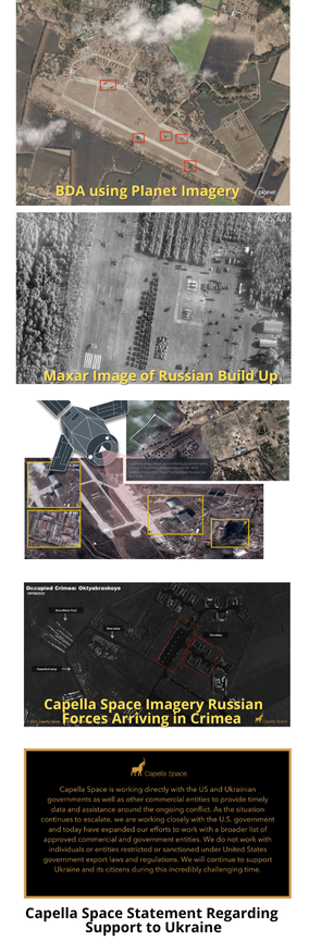
1 Mar 2022: Ukraine is openly seeking the cooperation of commercial satellite operators. The goal is to obtain data, particularly from synthetic aperture radar, about the movement of Russian vehicles so that Ukrainian forces can respond.
– Mykhailo Fedorov, the Vice Prime Minister and Minister of Digital Transformation of Ukraine stated: “We badly need the opportunity to watch the movement of Russian troops, especially at night when our technologies are blind in fact! SAR satellite data is important to understanding Russian troop and vehicles movements at night considering that clouds cover about 80 percent of Ukraine during the day”
– EOS Data Analytics (a company founded by Ukrainian Max Polyakov) offered to quickly analyze and process data for use by the Ukrainian Defense Service. The company has set up a webpage here with more information.
– Commercial companies have been releasing high-resolution satellite imagery into the public domain to showcase their capabilities. While this has been impressive, such releases have been more useful for public relations purposes than for giving actionable information to the Ukrainian military. The data is often two or three days old.
– Polyakov appealed to Planet Labs, Maxar Technologies, Airbus, SI Imaging Services, SpaceView, BlackSky, Iceye, Capella, and other companies to provide the needed data.
– Capella Space turned down the Polyakov-initiated request, saying, “We do not work with individuals or entities restricted or sanctioned under United States government export laws and regulations.”
– Capella Space did state that they are “working directly with the US and Ukrainian governments as well as other commercial entities to provide timely data and assistance around the ongoing conflict”
Read excellent review of Open Source (including Space) Intelligence in the Ukrainian conflict.
This is the first major war in which commercially available satellite imagery has played a significant role in providing open source information about troop movements, military buildups in neighboring countries, flows of refugees, and more.
The role of such a powerful, widely available technology has yet to be defined in a warfighting domain, and it’s not clear whether private companies are willing to freely hand over raw data to another commercial company with the intent of helping one side in the conflict.
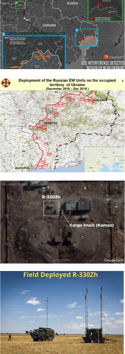
1 Mar 2022: Localized Russian jamming of GPS signals in Ukraine has been detected by US forces in the region, but so far has not interfered with US support operations, according to Pentagon officials.
– Jamming has been detected as far out as the Black Sea by US reconnaissance aircraft, but the source stressed it hasn’t had any impact on mission capability.
– US Space Command spokesperson said, “There are no impacts to U.S. and Allied forces in Europe at this time.”
– Senior defense official told reporters today that the US suspects Russia has been holding back in utilizing its vast toolset for electronic warfare so far
– It’s unclear if the jamming has had an effect on Ukrainian operations in-country.
– HawkEye 360 operates a constellation of satellites to monitor radio frequency signals and pinpoint their location. The firm demonstrated its ability to detect and monitor GPS interference last year and now sells related products.
– Shortly before the Russian invasion began analysts detected GPS interference north of Chernobyl.
– In November, HawkEye 360 also noted GPS interference near the border between pro-Ukrainian and Russian-backed forces in Luhansk and Donetsk regions. With publicly available information, the company confirmed that the operation of unpiloted aircraft in the region was disrupted by the interference.
– The source of jamming could be the Russian R-330Zh “Zhitel”; the Organization for Security Cooperation in Europe’s Special Monitoring Mission to Ukraine (OSCE SMM) reported a sharp increase in R-330Zh “Zhitel” GPS jamming activity in eastern Ukraine in 2019.
– The R-330Zh has been a staple in Russian anti-UAV operations in eastern Ukraine since 2015…Although the R-330Zh at times has been caught operating alone, it is often spotted alongside other EW systems, possibly as part of mobile EW groups to counter drones.
Localized jamming of terrestrial GPS receivers — rather than jamming or cyber attacks on the 30 GPS satellites currently operated by the Space Force — has become almost routine, since the 1998 Kosovo war, in many of today’s conflict zones such as Syria. In 2021 the US issued a new policy, Space Policy Directive 7 (SPD-7), to improve GPS…and increasingly focus on making GPS signals more jam resistant, as well as improving cybersecurity.
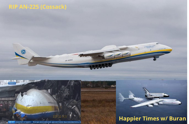
4 Mar 2022: In response to International Sanctions, the head of Roscosmos, Dmitry Rogozin has withdrawn Russian space support to international missions.
– Cooperation between Roscosmos and other international space agencies and corporations has virtually ceased as a result of the conflict in Ukraine.
– Roscosmos halted Soyuz launch activities out of French Guiana and recalled dozens of engineers and technicians and suspended Soyuz rocket operations, grounding a pair of European Galileo navigation satellites previously set for launch in early April.
– Another Soyuz rocket was scheduled to take off from French Guiana later this year with two additional Galileo navigation satellites.
– Russia also halted launch preparations for 34 OneWeb satellites from Baikanur. Another six Soyuz launches were scheduled for later this year to complete the OneWeb constellation.
– Dmitry Rogozin issued two demands before acceding to the 5 Mar launch. First, OneWeb must guarantee its satellites will not be used for military purposes. And two, the UK government must give up its ownership of OneWeb.
– In response, OneWeb’s board unanimously voted to suspend all launches on Russia’s Soyuz rocket, the company is now looking to India, Japan and the US for alternative launchers.
– In protest of Russia’s invasion of Ukraine, Germany put its eRosita telescope aboard Russia’s Spektr-RG space observatory into safe mode.
– Two NASA astronauts are presently training in Russia, with five more scheduled to go, while three Russian cosmonauts are training in Houston. European officials said relations on joint spaceflight projects are continuing.
– Rogozin also halted delivery of Russian rocket engines stating: “In this situation, we can no longer supply the U.S. with our rocket engines that are the best in the world. Let them fly on something else, like their brooms, or whatever.”
– In a related story, efforts are underway to rename the SpaceX Falcon 9 rocket to the “Nimbus 2000.”

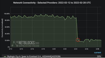
28 Feb 2022: Viasat Inc said it was investigating a suspected cyberattack that caused a partial outage in its residential broadband services in Ukraine and other European countries.
– The outage was across Viasat’s KA-SAT network, which provides high-speed satellite internet coverage in Europe and Mediterranean markets.
– The outage could have been due to a distributed denial of service (DDoS) attack, Sky News reported on Monday. Such attacks hit a number of Ukrainian banks and government websites shortly before Russia’s invasion last week.
– German internet service provider EUSANET is also reporting outages that began around the same time as both the Viasat outages and the Russian invasion.
– Golem, a German IT news site, reported Sunday that Viasat emailed partners with confirmation that broadband services across Europe were offline, starting Feb. 24 with Ukrainian spot beams.
– It is unclear how many customers Viasat has in Ukraine, and the company declined to say how many are being affected.
– An additional look on 4 March revealed service has been restored.
– Viasat operates large satellites in geosynchronous orbit — meaning they are stationary at a point about 35,000 kilometers from Earth to maximize coverage area.
– Currently Viasat operates a constellation of 4 GEO satellites (Anik F2 <2004>, Wildblue 1<2006>, Viasat 1<2011> and Viasat 2<2017>. A 5th, Viasat 3 is scheduled to launch summer ’22.
1 Mar 2022: Romania became the 16th country to sign the NASA-led Artemis Accords for cooperation in space exploration
– Marius-Ioan Piso, the longtime head of the Romanian Space Agency didn’t state what role Romania sought in the Artemis program that led it to sign the Accords. “This spirit of collaboration was a main impetus for us to join the Artemis Moon exploration endeavor,” he said in the statement. “Among the clear benefits that emerge from the participation in this unique program, we see Artemis also as an attractor for the younger generation towards science, discovery, innovation – things that robots still cannot do.”
– Romania is the fifth member of the European Space Agency to sign the Accords, joining Italy, Poland, Luxembourg and the United Kingdom. France has also expressed an interest in signing the Accords but has yet to do so.

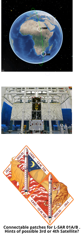
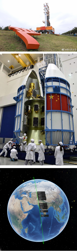
26 Feb 2022: China launched a Chang Zheng 4C (LM-4C) with the second Ludi Tance radar-imaging satellite from the Jiuquan Satellite Launch Center. The L-SAR 01B satellite now joins its predecessor, L-SAR 01A, in a sun-synchronous orbit. The two satellites are separated by 60 degrees. The two spacecraft are the first to launch for a new Chinese civilian radar imaging constellation deployed in low Earth orbit. Launch Video.
– The satellites transmit L-band radio signals and record the echo as they are reflected from the surface of the Earth. By taking a series of measurements as it passes over an area of interest, a satellite can produce higher-resolution images with a relatively small antenna.
– The SAR payload on Ludi Tance-1 01B includes an antenna with an area of around 33 square meters.
– The stated objectives of the Ludi Tance satellites are to aid in resource monitoring, mapping, and disaster management. They are part of China’s National Civil Space Infrastructure Development Plan for 2015 to 2025.
– L-SAR 01B will realize on orbit networking with L-SAR 01A and build the world’s first L-band double star constellation.
– L-SAR 01 is a distributed SAR satellite system, which is composed of two L-band SAR satellites with the same design parameters. In orbit, it has two formation flight modes of “follow-up flight” and “around flight”.
– In the “follow-up” formation mode, the dual satellites’ primary task is surface deformation interferometry. The objective is surface deformation monitoring to support industrial applications such as land subsidence, landslide, ground collapse and seismic deformation to identify potential geological disasters in complex areas. It is also an important satellite resource for emergency investigation of earthquake disasters and major geological disasters.
– In the “fly around” mode, the two satellites realize close-range collaborative earth observation. With synchronized operations the satellites can produce high-precision ground elevation measurement and support natural resources surveys.
– This was the 40th flight of the Chang Zheng 4C and the 87th overall for the Chang Zheng 4 series.
– Chang Zheng 4 can launch from three of China’s four main launch sites, the Jiuquan, Taiyuan and Xichang Satellite Launch Centers. About three-quarters of Chang Zheng 4 launches have been from Taiyuan, with the rest flying from Jiuquan. Chang Zheng 4 can reach sun-synchronous orbit from either Taiyuan or Jiuquan.
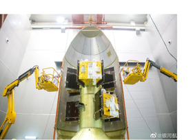
27 Feb 2022: China’s second Long March 8 rocket launched from Wenchang carrying a domestic record 22 satellites for a range of commercial Chinese space companies. This was the first Long March 8 to launch without the pair of side boosters used in the rocket’s first mission back in December 2020.
Launch Video.
– The Long March 8 combines the 3.35-meter-diameter new-generation Long March 7 kerosene-liquid oxygen first stage with a 3-meter-diameter hydrolox second stage from the older Long March 3A series.
– “To put it simply, we have hammered out a ‘carpooling’ solution to launch many small satellites in one successful launch mission,” Xiao Yun, chief commander of the Long March 8 rocket program, told CCTV.
– The Long March 8 has been slated for test development of vertical takeoff, vertical landing, during which side boosters would remain attached to the first stage. Saturday’s mission was expendable, launching over the sea from Hainan island.
– The payloads on the Long March 8 involved seven manufacturers with end users including seven commercial companies and two research institutes.
– All payloads were placed into sun-synchronous orbit with ~550km apogee and ~524km perigee.
– CGST launched 10 new Jilin-1 imagine satellites for its constellation of remote sensing satellites of the same name.
– The current plan is to increase the size of the constellation to 138 satellites by 2030. This would provide images every 10 minutes with resolutions down to 0.72 meters of an area up to 11.6 kilometers per satellite.
– Including the 10 satellites on this launch, the total number of Jilin satellites is 33.
– Small satellite maker Minospace manufactured five satellites aboard the mission. Two of these were the Taijing-3 (01) 240-kilogram optical and Taijing-4 (01) 250-kilogram synthetic aperture radar (SAR) satellites which will be operated by Minospace.
– Changsha-based commercial spacecraft maker and constellation operator Spacety launched the Chaohu-1 satellite, the first of the planned Tianxian SAR constellation in cooperation with the China Electronics Technology Group (CETC). The 325-kilogram satellite builds on the Hisea-1 SAR satellite launched on the previous Long March 8 flight.
– Hainan-1 (01) and (02) satellites weighing 60kg carrying imagers and automatic identification system (AIS) receivers for maritime surveillance.
5 Mar 2022: China launched the Xuancheng-1 mission onboard a Chang Zheng 2C from Xichang. This was a rideshare mission launching six Galaxy Space Yinhe communications satellites and one remote sensing satellite. Video.
– The launch went to a Low Earth Orbit with a 52-degree inclination and was confirmed a success shortly after launch.
– Some of the Yinhe satellites also have a remote sensing camera installed. These satellites are very similar to the UK OneWeb constellation in design and capabilities per satellite.
– The Galaxy Space Yinhe constellation is expected to have 1,000 satellites in the completed network.
– The 6 satellites will form an experimental communication network called “Mini Spider Constellation” to verify broadband internet technologies. Users will get access to high-speed internet service through satellite signals transmitted through ground-based gateway stations, according to engineers.
– The Mini Spider Constellation will give users 30minutes of nonstop access to broadband internet each time they connect their terminals such as mobile phones and laptops to the satellite system.
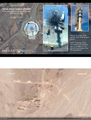
2 Mar 2022: Iran likely suffered another failed launch of a satellite-carrying rocket in recent days attempting to reinvigorate a program criticized by the West, even as Tehran faces last-minute negotiations with world powers to save its tattered nuclear deal in Vienna.
– Maxar TechnologiesSatellite images from 27 Feb show scorch marks at a launch pad at Imam Khomeini Spaceport in Iran’s rural Semnan province on Sunday. A rocket stand on the pad appears scorched and damaged, with vehicles surrounding it. An object, possibly part of the gantry, sits near it.
– Separate images from Planet Labs PBC suggest the attempted launch likely occurred sometime after 25 February.
– The rocket involved appears to have been Iran’s Zuljanah satellite launch vehicle, said Jeffrey Lewis, an expert at the James Martin Center for Nonproliferation Studies at the Middlebury Institute of International Studies who first noticed the attempted launch with colleagues.
Over the past decade, Iran has sent several short-lived satellites into orbit and in 2013 launched a monkey into space. The program has seen recent troubles, however. There have been five failed launches in a row for the Simorgh program, another satellite-carrying rocket. A separate fire at the Imam Khomeini Spaceport in February 2019 also killed three researchers, authorities said at the time.