issue 44 | 27 march 2022
The integrity flash
Analysis of Developments in the Space Domain
in this issue
Iran Conducts Successful Noor 2 Launch
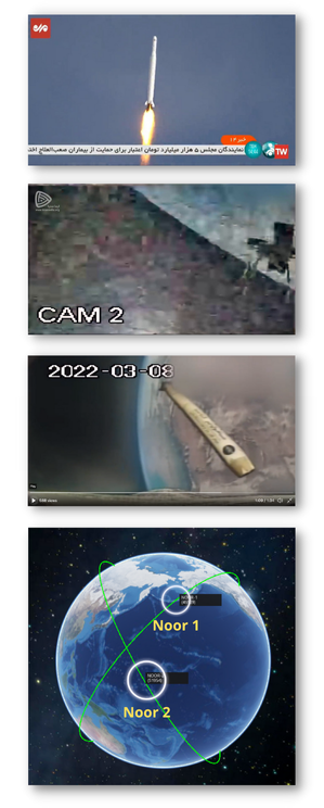
8 Mar 2022: Iranian officials said a Qased launcher successfully placed the Noor 2 satellite into orbit. Iran’s state broadcaster showed video of the launch, which apparently took off from the Shahroud missile range in the northeastern part of the country. See Video.
– The Qased rocket is made of three stages, the first stage is based on an Iranian ballistic missile upgraded to loft a small payload into orbit.
– Iran’s Revolutionary Guard Corps said it placed a satellite named Noor 2 into orbit. The government-run Islamic Republic News Agency described Noor 2 as a reconnaissance satellite. The news agency said ground teams had received the first signals from the spacecraft.
– Noor means “light” in Persian.
– The Noor 2 satellite likely weighed less than 100 pounds (45 kilograms) at launch, but Iranian officials revealed no more details about the mission. It appears to be a follow-up to the Noor 1 satellite launched on the same type of rocket in April 2020.
– U.S. military showed two objects — likely the rocket’s upper stage and Noor 2 — orbiting at an altitude of roughly 310 miles (500 kilometers) at an inclination of 58.3 degrees to the equator.
– This was the second use of the Iranian military’s Qased satellite launcher. Both flights of the Qased — at least those publicly known — have been successful.
– The launch comes days after satellite pictures suggested Iran’s civilian program suffered another failed launch.
– The capabilities of Noor-2 remain unknown. Iran launched the Noor-1 in April 2020. Noor 1 has not maneuvered and has been described by US Space Command as “a tumbling webcam.”
– The launch occurred as nations awaited Tehran’s decision in negotiations over the country’s tattered nuclear deal.
– The US alleged Iran’s satellite launches defy a UN Security Council resolution and called on Tehran to undertake no activity related to ballistic missiles capable of delivering nuclear weapons.
– The US imposed sanctions on Iran’s civilian space agency and two research organizations in 2019, saying they were being used to advance Tehran’s ballistic missile program.
6 Mar 2022: North Korean state media reported the country performed data transmission and other key tests needed to develop a spy satellite. This was the second such test in about a week, indicating the country intends to conduct a prohibited long-range rocket launch soon.
– North Korea’s Central News Agency said it conducted “another important test” the day before on a reconnaissance satellite. Authorities tested the data transmission, reception and ground-based control systems.
– Outside experts believe North Korea fired a ballistic missile carrying a camera to perform the tests described in the KCNA report.
– On 28 Feb, North Korea said it tested a camera designed for a reconnaissance satellite and released space-based photos of Earth, a day after its rivals said it conducted a ballistic missile launch.
– A spy satellite is among a long wish list of new weapons systems that Korean leader Kim Jong Un vowed to cope with what he calls U.S. hostility.
– It’s unclear if North Korea developed a sufficiently capable camera to be installed on a satellite, as the satellite photos the country released last Monday didn’t include high-resolution imagery.
– North Korea put its first and second Earth observation satellites into orbit in 2012 and 2016, but foreign experts say neither transmitted any imagery back to North Korea.
– Experts say North Korea will likely conduct a spy satellite launch ahead of a major political anniversary in April, the 110th birthday of state founder Kim Il Sung, the late grandfather of Kim Jong Un.

7 Mar 2022: Bahrain became the 17th country to join the Artemis Accords regarding principles for cooperation in space exploration and expands beyond traditional spacefaring nations.
– Mohamed Al Aseeri, head of the National Space Science Agency of Bahrain, signed the Accords 2 Mar during the U.S.-Bahrain Strategic Dialogue. While the signing was briefly mentioned in those meetings, it was not formally announced by NASA and the State Department until 7 Mar.
– Bahrain is a newcomer to space, having established its space agency in 2014. That agency focused primarily on space applications, rather than exploration. The country’s launched its first satellite in Dec 2021. The cubesat, jointly developed with the United Arab Emirates called Light-1, rode on a SpaceX Dragon cargo resupply mission to the International Space Station in Dec 2021.
– Bahrain has not announced any plans to participate in space exploration activities associated with the Artemis lunar exploration campaign.
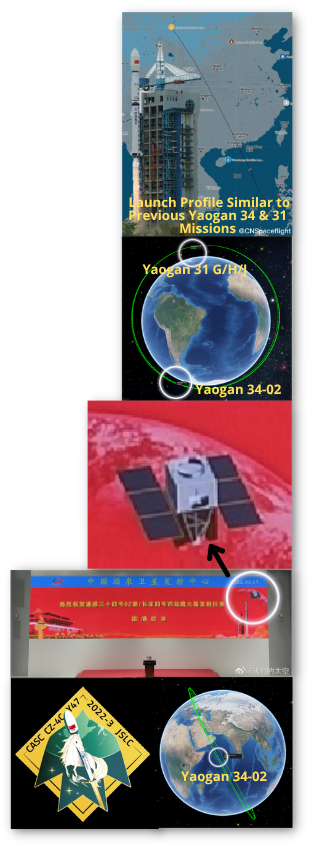
17 Mar 2022: China launched Long March 4C with a new classified Yaogan satellite into orbit from Jiuquan marking China’s sixth orbital launch of 2022. Launch Video.
– The Yaogan-34-02 satellite joins the first Yaogan-34, launched 30 Apr 2021. CASC states all Yaogan-34 satellites will operate as a network.
– The first Yaogan-34 satellite is in a 1,116 by 1,063km orbit inclined by 63°, closely matching the Yaogan-31 D/E/F satellite triplets.
– Yaogan-34-01 lags behind the Yaogan-31 D/E/F formation by approximately 10 minutes.
– Yaogan-34-02 is in a 1,097km low Earth orbit (LEO) with 63.4° inclination, similar to Yaogan-31 G/H/J.
– Yaogan-34-02 currently lags behind Yaogan-31 G/H/J by ~45 minutes.
– The Yaogan-31 satellites’ orbits suggest they are analogous to US DoD Naval Ocean Surveillance System (NOSS) satellite triplets. Watch Video of Satellite Triplets (Yaogan 16 & Yaogan 20).
– NOSS satellites locate and track ships at sea by detecting radio transmissions and analyzing them using time-difference-of-arrival (TDOA).
– A mission success screen displayed at the Jiuquan Satellite Launch Center provided a rare potential clue as to the nature of the satellite with an image of a spacecraft bus in the top right.
– The Yaogan military Earth-observation satellites are reconnaissance satellites with a variety of uses. These range from scientific experiments to survey land and crops, and disaster and environmental monitoring. Beyond that, these satellites most likely also fulfill military services, but that is never communicated publicly by the Chinese operators.
– China’s official release stated the Yaogan-34 series “is mainly used for land census, urban planning, and land confirmation. It can meet the needs of rapid earth observation revisitation and provide information for China’s “Belt and Road” construction.
– This suggests Yaogan-34 is an optical remote sensing satellite.
– Pairing an optical remote sensing satellite with the Yaogan 31 triplets could yield the ability to “tip and cue” between sensors and use imagery to confirm ship or other target locations and identities.
– This launch also featured a test for future payload hosting on the Chang Zheng 4C third stage. This is comparable to the photon stage built by the American company Rocket Lab, in which the stage would conduct a second mission after the deployment of the primary payload.
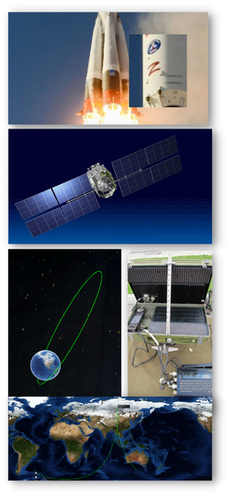
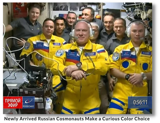
22 Mar 2022: Russia launched the Meridian-M No 10L satellite onboard a Soyuz 2.1a from the Russian Plesetsk Cosmodrome. This was first space launch for Russia’s military since forces invaded Ukraine last month. Launch Video.
– Meridian 10 joins 3 other currently active Meridian satellites (7/8/9). The satellite is in a very highly elliptical Molniya orbit of 900 x 39,000km, with an inclination of 65°.
– While the Meridian-M network does provide support for the Russian military, the timing of this launch is not related to the current war in Ukraine. The deployment of the Meridian-M constellation has been underway since 2019, and the overall Meridian network since 2006.
– The satellite is part of the upgraded constellation’s M-series. One more upgraded M-series satellite is planned for later this year.
– Due to their elliptical orbits, Meridian satellites link Russian ground forces, aircraft, ships, and command centers in the Arctic, Siberia and North Sea – outside the reach of stable communications coverage unattainable from geostationary satellites over the equator.
– The Russian Defense Ministry said the satellites relay signals between coastal stations and vessels and ice reconnaissance airplanes traveling along the Northern Sea Route in the Arctic Ocean. The Meridian satellites also serve users in northern Siberia and Russia’s Far East.
– Meridian- M No 10 is the third upgraded Meridian M-class spacecraft in orbit. The first of the new batch of Meridian M satellites launched in Jul 2019, followed by another in Feb 2020.
17 Mar 2022: Satellite operator Viasat is still seeing its connectivity services in Europe disrupted, more than two weeks after suffering a suspected cyber attack.
– Viasat’s KA-SAT network in Europe remains heavily impacted 18 days after an apparent cyberattack, one of several incidents as Russia invaded Ukraine on 24 Feb.
– Victor Zhora, Chief Digital Transformation Officer at the State Service of Special Communication and Information Protection of Ukraine, said the outage was “a really huge loss in communications in the very beginning of war…We believe that Russia is attacking not just with missiles and with bombs, but with cyber weapons…I hope detailed attribution will be made later.”
– The hack affected modems in Ukraine and across Europe, notably those used in wind turbines used by Germany’s Enercon. In a statement issued on Tuesday, Enercon said that 85% of its modems were offline and a full recovery would take “some further weeks.”
– German BSI issued at least one internal report including an interview with a German ISP that believed the attacks were caused by malicious firmware.
3 Mar 2022: Hacker group announced on Telegram it will try to compromise GLONASS, the Russian GPS consellation. Other targets include Russian media, power grid & railways.
– Ukraine’s hacker underground named GLONASS as one of its top priorities, according to media reports citing the “IT army” Telegram channel
– On Wednesday, hacker group NB65 said they successfully compromised Russia’s space agency (Roscosmos) and its vehicle monitoring system.
– NB65 claimed they deleted the agency’s WS02 software, an open-source application program interface management tool, rotated credentials, and shut down the server.
– NB65 claimed the attack prevented Russia from controlling their spy satellites.
– Head of Roscosmos, Dmitry Rogozin, denied the organization’s infrastructure was hacked yet reiterated that hacking a satellite would constitute a reason for war.
– The hacker community started rallying to help Ukrainians beginning with the Russian invasion on 24 Feb.
– With Anonymous being the most prominent one, numerous hacker groups and researchers partake in various campaigns to help Ukraine. Cyber activists targeted Russian state-controlled media outlets TASS, Kommersant, Izvestia, Fontanka, and RBC, pushing them offline.
– Anonymous claimed responsibility for disabling prominent Russian government, news, and corporate websites. They also leaked data from entities including Roskomnadzor, the federal agency responsible for censoring Russian media.
– An independent cyber security analyst noted Russian noted 92 of 100 analyzed databases were compromised…and the activities correlated closely to Anonymous’ claims.
– An unknown group has set up a website tool that allows people to participate in distributed denial of service (DDoS) attacks against Russian websites that it claims are spreading disinformation.
– Cybersecurity firms urged civilians to join the cyberwar via an app to attack Russian websites spreading disinformation.
In spite of the calls to action there have been no reported disruptions to GLONASS or other Russian space capabilities since the beginning of the conflict. Most of the cyber activity has disrupted websites of major Russian organizations and media agencies.

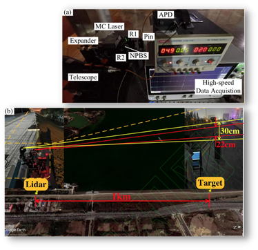
16 Mar 2022: Researchers at the National Defence Technology University say their laser imaging technology can identify small objects in space with unprecedented accuracy…the scientists say it could be used to guide laser beams removing small pieces of hazardous space debris.
– A team of Chinese military scientists say they have achieved a breakthrough in laser imaging technology that will allow ground stations to identify and track a target in space with unprecedented accuracy.
– The results suggest that the radar can image a thumb sized object in near-Earth orbit with a resolution of up to 3 millimeters (0.1 inches).
– This accuracy is two orders of magnitude higher than the
best results achieved by similar devices in the US and other Western countries, according to researchers.
– The technology could also help guide ground-based laser beams to remove small pieces of space debris that threaten satellites and spacecraft.
– “Centimeter or even millimeter-level resolution for space object imaging in the 100km [62-mile] range can be achieved in the
foreseeable future with a performance far superior to those achieved by traditional optical or radar imaging technologies,”said the researchers.
– The technology could be also used to study satellites to obtain valuable information about their design, technology, status and purpose.
– The technology was first proposed by American scientists in the late 1980s and researchers around the world have been working to improve it.
– Laser reflection tomography, inspired by hospital CAT scans, uses laser beams to illuminate the target’s surface and reconstruct the image from light particles bouncing in various directions.
– The resolution on the images obtained using this method is determined by small differences in the angle of the laser beams when they hit the target, rather than the distance from the observer.
– By improving the quality of the laser source and sensitivity of the receiving device, scientists could obtain ultra-sharp images of a tiny object from a long distance away.
– The machine’s actual performance in space surveillance remains classified, but the researchers revealed part of its potential in a ground experiment. The device, mounted on the bank of a reservoir in a suburban area of Hefei city produced sharp images of a 5cm wide, rotating target a kilometer (0.6 miles) away.