Analysis of Developments in the Space Domain
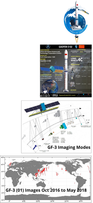
22 Nov 2021: China launched a CZ-4C (Long March 4C) containing the second Gaofen (“high resolution”) 3 from Jiugan Satellite Launch Center (JSLC) pad SL-2 (South Launch Site 2). The Gaofen-3 is a C-band radar imaging satellite, used for remote sensing and Earth observation.
– The Gaofen-3 satellites are based on the CS-L3000B bus, built for a lifetime of up to 8 years. They are equipped with a Synthetic Aperture Radar (SAR), a data transmission system, and utilize Control Moment Gyros (CMGs) for orientation in space.
– This satellite is part of the Chinese High-resolution Earth Observation System (CHEOS) program, which was proposed in 2006 and initiated in 2010 with the goal to improve and update China’s Earth observation system.
– This satellite is part of the Chinese High-resolution Earth Observation System (CHEOS) program, which was proposed in 2006 and initiated in 2010 to improve and update China’s Earth observation system.
– It is part of the Chinese government’s “One belt one road” regional development project and provides geographical and environmental mapping as well as disaster observation and prevention.
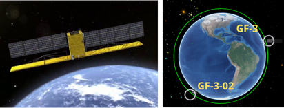
– Gaofen 3-02 will work with the original Gaofen-3 satellite, launched in Aug 2016 to a 735×747 km Sun-synchronous orbit (SSO), and focus on ocean observation with an image resolution of one meter.
– Sun-synchronous orbit (SSO) is a special type of orbit which nearly passes over the planet’s poles. Each time the satellite passes over any location on Earth, it is always the same local solar time.
– The satellite was developed by the China Academy of Space Technology (CAST) and features upgrades over the first Gaofen -3, including optimized imaging, improved ship-positioning technology and real-time onboard processing that makes imagery available much faster than transmitting raw data does.
– The Chang Zheng 4C (CZ-4C) is mainly used for low Earth orbit
(LEO) and SSO missions, like this particular one. It can lift 4,200 kg to LEO and 2,800 kg to SSO. The launch mass of this payload is reported to be about 2,779 kg.
According to the “Chinese national spatial infrastructures program”, there will be three satellites, the GF-3 satellite and two follow-on satellites in orbit in 2020, which will further support and promote the construction and development of the civil military integration of space-based information systems, while becoming an important technical support tool for the implementation of marine development, China land resources and environment monitoring and disaster prevention and mitigation.
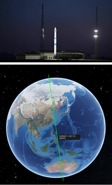
24 Nov 2021: China’s commercial ExSpace launched a Kuaizhou-1A rocket with the experimental Shiyan-11 satellite from the Jiuquan Satellite Launch Center in the Gobi Desert. This is believed to be the first launch of a government/defense satellite using a commercial launch provider. Launch Video.
– The Kuaizhou-1 is based on the Dongfeng 21 (DF-21) intermediate range ballistic missile and uses solid propellant for its first three stages, with a liquid-fueled fourth stage to inject satellites into orbit. It made its first flight in 2013, with the commercial version known as Kuaizhou-1A first flying in January 2017.
– Launch cadence for the KZ-1A has increased considerably following a 1-year grounding following a Sep 2020 failure. The 24 Nov launch was the 13th KZ-1A launch (12 successful), and third since Sep 2021.
– Kuaizhou rockets typically launch commercial payloads, such as Jilin-1 satellites for Changguang Satellite Technology.
– The KZ-1A is designed to launch after being set up by a transporter-erector launcher (TEL) vehicle, and has minimal infrastructure requirements which are claimed to bring substantial cost savings.
– Little is known about the Shiyan-11 payload, only that it is for technology development. However, given its sun-synchronous orbit (489 x 502 km x 97.5 deg), a reasonable hypothesis is that Shiyan-11 could be used to test Earth imaging systems or radar mapping. Other Shiyan series spacecraft have been used to test experimental technologies in different orbits.
The Kuaizhou-1A can launch up to 300 kilograms to low Earth orbit or 250 kilograms to a 500-kilometer sun-synchronous orbit at an advertised price point of $20,000 per kilogram. ExPace is planning for the potential of multiple additional Kuaizhou-1A launches before the end of this year, along with the second launch of the Kuaizhou-11 which can carry heavier payloads up to 1500 kg to low Earth orbit.
26 Nov 2021: China launched a Long March 3B carrying the ChinaSat-1D to Geostationary Transfer Orbit. Other Zhongxing satellites are at 66° east and 130° east longitude. ChinaSat-1D is believed to provide Chinese military tactical communications. Launch Video.
– The ChinaSat-1 series satellites are specifically designed
for military communications, with the first launched in 2011.
– China has two types of military communications satellites. ChinaSat- 1D is used for tactical communications providing Chinese forces with secure data and voice transmission via C-band and UHF. The ChinaSat-2 series uses the other military communications type, Shentong, of similar purpose but via Ku-band.
– As of 5 Dec 2021, ChinaSat-1D remained in GTO.
This launch also exhibited an upgrade of the CZ-3B with a “wind compensation” system to allow for higher wind tolerance and thus better resilience to launch conditions.

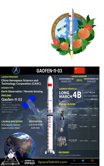
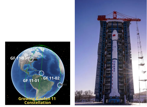
20 Nov 2021: China launched the Gaofen (GF) 11-03 imaging satellite using its Chang Zheng-4B rocket. The launch took place from the Taiyuan Satellite Launch Center. This is China’s 44th orbital mission of 2021. See Launch Video.
– Gaofen 11-03 is the third in a series of high-resolution optical imaging Gaofen 11 satellites. The full capabilities of the Gaofen 11 spacecraft have not been published.
– GF 11-03 has been placed in a 243 x 695 km x 97.5 deg orbit. The orbit is expected to circularize over the next 5-6 months. GF 11-01 and GF 11-02 operate in orbits between 490-500km.
– Gaofen 11-03 is the third in a series of high-resolution optical imaging Gaofen 11 satellites. The full capabilities of the Gaofen 11 spacecraft have not been published.
– GF 11-03 was placed in a 243 x 695 km x 97.5 deg orbit and expected to circularize over the next 5-6 months. GF 11-01 and GF 11-02 operate in orbits between 490-500km.
– Gaofen 11 satellites likely form the optical high-resolution component of the state-sponsored China High-definition Earth Observation System (CHEOS) constellation. CHEOS is unrelated to the smaller commercial Jilin-1 Gaofen satellites.
– Gaofen 11-01 was launched in July 2016. This was followed by Gaofen 11-02 in Sep 2020.
– Gaofen 11 satellites operate in sun-synchronous orbits, with a perigee of approximately 450km, apogee of around 690km, and 97.4 degree inclination.
Open Source analysis from 2018 estimated GF-11’s mirror size at 1.7m. A mirror of this size equates to a ground resolution of 8-10cm at perigee (~247km). At an average altitude of 470km, the resolution is still 15-20cm, surpassing all commercial and most reconnaissance satellites. This propels China into the select club of countries that can acquire NIIRS 8-9 satellite imagery, meaning the resolution is high enough to identify small hand-held weapons.
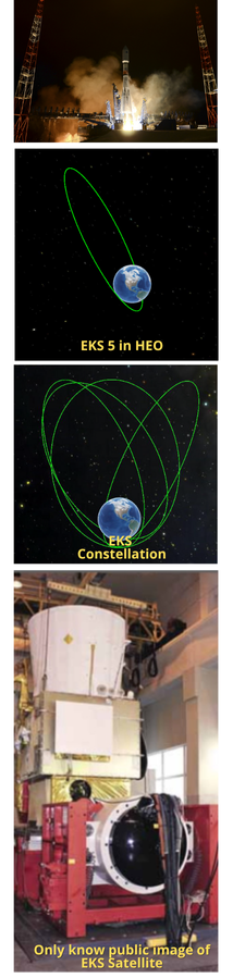
25 Nov 2021: Russia launched a Soyuz-2-1b rocket from Plasetsk carrying a classified payload believed to be the fifth Kupol (EKS-5 or Tundra-5) missile warning satellite. As with other missile warning spacecraft, Russia placed the new satellite into a Highly Elliptical Orbit (HEO) to maximize dwell time over the northern hemisphere. See previous FFF article.
– No official information on the nature of the payload has been released but the ground track of the launch matched previous missions delivering satellites known as Tundra or Kupol.
– The overall network is officially known as EKS OiBU for Edinaya Kosmicheskaya Sistema Obnaruzheniya i Boevogo Upravleniya, which can be translated as “Integrated Space System for Detection and Battle Command” or EKS for short.
– EKS satellites are believed to have infrared telescopes designed to detect heat sources which may indicate the launch of a missile. Other instruments on the satellite include optical and ultraviolet equipment to gather further data.
– EKS-5 was launched into a Molniya orbit of around 38500 x 1600km, 63.5 degrees. This is a HEO so that Tundra satellites spend much of their time around apogee. The four previous EKS satellites have also been sent to a similar orbit so the same is expected for Tundra 5. Furthermore, another five of these early warning system satellites are set to be launched by an unknown date to complete the EKS series.
– EKS satellites also carry Balka, a nuclear explosion detection payload.
In the Soviet era, there were no more than 9 simultaneously operating HEO satellites. More HEO satellites will be launched in the coming years. In Nov 2015, the Russian Ministry of Defense said the ultimate goal was to have a constellation of ten satellites. During 2020, Russian military officials promised to complete the deployment of the EKS constellation by 2024.
These may all be the Tundra HEO satellites as the GEO satellites lag far behind and may still be in the design phase. Satellites are only one element of the country’s early warning system. Russia also possesses a large network of ground-based early warning radars, having been spectacularly upgraded over the past 15 years to provide coverage of all potential attack zones, a capability never achieved in Russia/Soviet history.