issue 31 | 26 september 2021
The integrity flash
Analysis of Developments in the Space Domain
in this issue
15 September 2021: Chinese news reports that Chinese President, Xi Xipeng recently inspected the military base in Xi’an, Shaanxi province. During his visit he remarked “It is necessary to strengthen space traffic management to ensure stable and orderly operation of outer space.” He also emphasized the need for improving international cooperation in space security.
– After receiving a report from base personnel, Xi addressed the military audience and affirmed the important role that the base has played in the development of my country’s aerospace industry.
– Xi stated that space assets were national strategic assets that must be managed and used, and protected.
– Specifically Xi called for the developing and strengthening space protection forces, and improving disaster tolerance, engagement survival, and information protection capabilities.
– Xi called for international cooperation in space security to improve the effectiveness of space crisis management and overall management of the space domain.
– Finally, Xi acknowledged the reality of increasing volume of space launches and the need to optimize organizational structure & renew monitoring & tracking techniques to keep pace.

Check the Oil? On-Orbit Servicing
23 September 2021: Several companies are developing technologies for extending satellite lifetime in multiple orbital regimes. Northrup Grumman announced a new mission extension pod (MEP) capability that will utilize robotic technology from DARPA. Others are experimenting with on-orbit refueling and advocating for the development of standard interfaces.
– Northrup Grumman is preparing to launch a new servicing vehicle in 2024. The mission robotic vehicle (MRV) is equipped with a robotic arm that will install propulsion jet packs on dying satellites. VIDEO
– MRV is the second generation servicing vehicle and includes robotic payload developed by the Defense Advanced Research Projects Agency.
– 6 undisclosed customers have signed up for servicing.
– MRV is to install small propulsion devices known as mission extension pods. One of these units is inserted in the back of a client satellite propulsion system, adding six years of life to most geostationary satellites. The 2024 launch will carry three pods.
– In addition to station keeping, the company is looking at other services like detailed inspections, relocations of client vehicles or simple repairs such as releasing a solar array that is stuck or an antenna that doesn’t deploy properly.
– Northrup Grumman is currently providing mission extension services for 2 Intelsat spacecraft.
– There is also growing interest in providing on-orbit servicing for LEO spacecraft.
– NASA and Maxar Technologies are developing the On-orbit Servicing, Assembly, and Manufacturing 1 (OSAM-1) to robotically refuel the Landsat 7 imaging satellite.
– Both Northrop Grumman and Lockheed Martin are actively working to shape the standard refueling interface that would help create a market for gas stations in space.

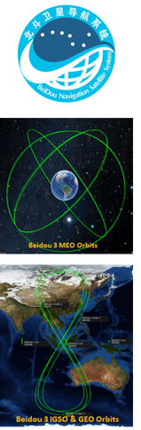
China’s Beido-3 reached full operational status in June 2020 marking a major milestone in a 20+ year journey to develop a completely indigenous GNSS. A recent open source report provides a brief history of the project, its features, and what may be on the horizon.
– With the launch of a Long March 3B in June 2020 the final Geostationary Beidou satellite was placed into service marking the end of a 20 year journey.
– China’s investment in developing its own PNT constellation increased in the early 2000s after several “wake-up calls” in the 1990s.
- The Yinhe Incident in 1993: the US suspected a Chinese cargo ship (“Yinhe Hao”) of carrying chemical weapons for Iran, and used several means to strand the Chinese ship in international waters, including disrupting GPS signals.
- The Third Taiwan Strait Crisis in 1996: China launched a number of missiles close to northern Taiwanese waters. Several of these missiles failed to reach target. There was belief within China that the failures were due to the US disrupting GPS signals. Per one PLA Colonel: “It was a great shame for the PLA … an unforgettable humiliation.”
– Beidou evolved through a series of 3 phases.
- Beidou-1 (2000-2012): A triplet of geostationnary satellites, aimed at providing active PNT services and covering exclusively the territory of China. It was deployed between 2000 and 2003, and was decomissioned in 2012.
2. Beidou-2 (2004- ): Developed between 2004 and 2012, Beidou-2 was more advanced and broadened satnav coverage to the Asian-Pacific region. It differs from other GNSS constellations by combining MEO satellites with GEO and IGSO satellites (respectively 4, 5, and 5 satellites). GPS, GLONASS and Galileo on the other hand are purely MEO constellations. PNT services starting from Beidou-2 were mainly passive.
3. Beidou-3 (2013- ): Similar hybrid constellation with its predecessor but provides global coverage with 24 MEO satellites, 3 GEO satellites, and 3 IGSO satellites. While the MEO satellites provide the worldwide coverage, the GEO and IGSO satellites aim at enhancing performance and services for China and Asia Pacific countries. Beidou-3 also comprises a ground segment, composed of a number of ground stations, as well as inter-satellite links, which enable satellite telemetry and control without having a global network of ground stations.
– In addition to providing geolocation services, Beidou users can also use it to send messages. Within China and Asia-Pacific, users can send messages up to 1000 Chinese characters, thanks to the coverage of the 3 GEO satellites in the region. Users outside of the region are limited to 40 character messages.
– The government maintains tight control of both the Beidou space and ground segments. However there is considerable competition within the user segment to provide user equipment and services.
– Local Chinese governments have also been supportive through the creation of Beidou-centered industrial parks, providing facilities and investment to domestic startups. Outbound political strategies such as BRI (Belt and Road Initiative) are also likely to promote Chinese-designed and manufactured satnav solutions.
While the space segment of the Beidou-3 constellation (ie. the satellites) were completed in June 2020, more sophisticated GNSS augmentation services are still in the deployment phase and should be completed by 2025 based on various reports by China’s Satellite Navigation Office (CSNO).
23 September 2021: Rocket Lab will launch an Astroscale mission to rendezvous with a spent rocket stage in low Earth orbit, a prelude to eventually deorbiting the stage. A Rocket Lab Electron will launch the Active Debris Removal by Astroscal Japan (ADRAS-J) from its Launch Complex 1 in New Zealand in 2023. See CONOPS VIDEO
– ADRAS-J will rendezvous with and inspect an upper stage left in orbit by a Japanese launch.
– The second phase, which will involve an attempt to deorbit the upper stage, has not yet been competed by JAXA.
– Orbital debris removal missions require require precise orbital insertion so that the spacecraft can reach the rocket stage. Rocket Lab has developed a kick-stage capable of this level of accuracy.
– Astroscale has already begun testing active debris removal technologies on its first spacecraft, End-of-Life Services by Astroscale-demonstration (ELSA-d), which launched in March 2021 on a Soyuz rideshare mission.
– ELSA-d performed the first release and capture of a client spacecraft on Aug. 25, deploying the small spacecraft from the main one and then capturing it using a magnetic mechanism. A series of more complex tests, including attempting to capture the client while tumbling, are scheduled for the next several months.
-YG-36(04) is in the typical orbit for this constellation with an apogee of 506km, perigee of 493km and an inclination of 35°. These numbers will shift over the next few weeks as YG-36(04) maneuvers into the lead-trail-trail formation.
-As has become the pattern, YG-36(04) is plane matched with a YG-35 triplet, this time YG-35(03).
– Yaogan 36-03 is co-planar with Yaogan 35-05 satellites which launched on 6 Sep 22. Yaogan 36-01 is co-planar with Yaogan 35-01, and Yaogan 36-02 is co-planar with Yaogan 35-02.
-Two of the three satellites YG-36(04) satellites were developed by the Aerospace Dongfanghong Satellite Co., Ltd., with the third provided by the Shanghai Academy of Spaceflight Technology (SAST), both of which operate under CASC. (This is true for all YG-35 & 36 triplets).
– Few details about the satellites were disclosed by China’s government-owned media. The country’s Xinhua news agency said the satellites will be mainly used to test “new Earth-observation technology.”
– Looking at similar orbits and formations, between 2018 and 2020 China launched 8 XJS satellites with similar orbital parameters. All are 35° inclined and between 460-475km in altitude.
– Yaogan-35/36 satellites may operate in lead-trail configuration, with the lead satellite potentially cueing the two trailing vehicles.

22 September 2021: Xona Space Systems has raised $8 million to fully fund an orbital demonstration in 2022 of its navigation payload. The spacecraft has lined up a SpaceX Falcon 9 rideshare mission in mid-2022 and will be the first launch of a dedicated, commercial positioning, navigation and timing (PNT) satellite.
– The demonstration is an important step towards realizing Xona’s planned constellation of 300 cubesats. Deployment is expected to begin in 2023 and be completed in 2026.
– Xona’s spacecraft will operate in LEO and have 10 times better accuracy than standard GNSS. The satellites will be unaffected by poor weather that can disrupt ground-based light detection and ranging (LIDAR) solutions for PNT.
– Improved accuracy and all-weather capability will be essential for the emerging autonomous vehicle industry.
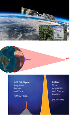
– A second company, Satelles, has been providing assured PNT services to back up GNSS since 2016 over Iridium’s satellites in LEO (500 mile altitude).
– GPS and other GNSS satellites typically operate in Medium Earth Orbit (MEO) at an altitude of ~ 12,500 miles.
– Increased proximity to the users results in greater signal strength and improved reception in buildings and obstructed terrain.
– Both Xona and Satelles efforts promise encrypted PNT services. Today’s GPS signals available to civilians are unencrypted and susceptible to spoofing or other forms of disruption.
It is possible that the PNT industry is at a commercial inflection point where it makes more sense to improve GNSS services with cubesats, which can broadcast stronger signals closer to Earth, rather than focusing on patching the service on the ground or improving accuracy with terrestrial solutions.