issue 63 | 3 jan 2023
The integrity flash
Analysis of Developments in the Space Domain
in this issue
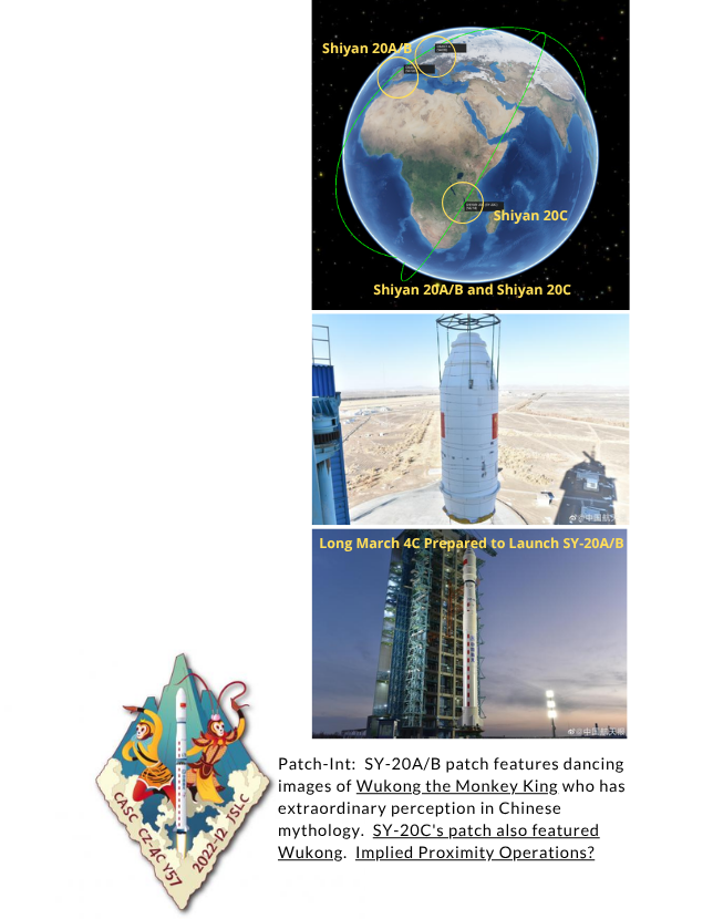
Happy Holidays: China Launches Shiyan-20A & 20B
19 Dec 2022: China launched a Long March 4C from Jiuquan with test satellites Shiyan-20A and 20B on board. China launched Shiyan-20C less than 2 months previously, on 29 Oct 2022. As with nearly all other Shiyan (“experiment”) Satellites, China has released very little public information regarding the spacecraft of their mission . Launch Video.
– Shiyan 20A/B (2022-169A/B) share similar orbital characteristics with SY-20C. All three satellites area at nearly 800km at apogee and are inclined 60°.
-The Shiyan-20 satellites appear to be the only Chinese satellites operating at this altitude and inclination.
-Other Shiyan satellites at similar altitudes (SY-5, SY-6(02), SY-3, and SY-4) all appear to be in sun synchronous orbit.
-There are no Yaogan satellites at this altitude. Only Gaofen 3-02 and 3-03 are at similar altitude but are also in SSO.
– Yaogan-31 satellites operate at a similar inclination, 63.4°, but have an apogee of 1,142km.
– SY-20A/B are co-planar with one another, the trailing spacecraft approximately 4min behind the lead.
– SY-20A/B are NOT co-planar with SY-20C, as the RAAN are offset by ~60°.
– The three Shiyan-20 spacecraft were built by different organizations, with Shiyan-20A constructed by the China Academy of Space Technology (CAST), 20B produced by the Shanghai Academy of Spaceflight Technology (SAST), and 20C developed by the Innovation Academy for Microsatellites of the Chinese Academy of Sciences (CAS Microsat).
– The official objective of the Shiyan-20 mission has been declared as “technology demonstration including spatial environment monitoring.”
– China used the LM-4C for SY-20A/B, SY-20C was launched using the LM-2D.
– Launch capacity for the LM-4C is believed to be about 4,200kg to LEO, the LM-2D is capable of ~1,300kg (SY-20C is believed to have a mass of ~1,200kg).
– There have been now been 8 Shiyan
launches from Jiuquan (SY-3, SY-4,
SY-5, SY-6(01), SY-6(02), SY-11,
SY-20C and SY-20A/B). This is
the first Shiyan mission from
Jiuquan that used the LM-4C SLV.
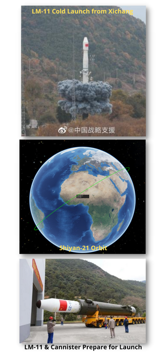
16 Dec 2022: China launched another Shiyan (“experiment” or “test”) satellite from Xichang using a LM-11 space launch vehicle (SLV). The SY-21 mission remains a mystery, official statements said it would be used for “in-orbit verification of new space technologies.” The spacecraft was developed by the Shanghai Academy of Spaceflight Technology (SAST).
Launch Video.
– China declared mission success 30 minutes after launch.
– SY-21 is now in a 495.8 x 476.3km orbit, and has an inclination of 36.0°.
– SY-21 is operating at a lower altitude than any other Shiyan mission with the exception of Shiyan-11 (490x476km Sun synchronous orbit).
– The mission marked the 15th launch of the 20.8 x 2m and 58-metric-ton four-stage solid Long March 11.
– The Long March 11 uses a cold launch system, which is expelled from its canister before igniting.
– This was the first Shiyan mission to use the LM-11 SLV.
– There are claims that this was the first Chinese launch to use 3D printing to build the satellite brackets in braced frame structures, shortening delivery time by 40%.
China’s Historic Launch Year:
This was China’s 7th launch in just 10 days, two of the launches were from new space launch vehicles. China has launched 64 times this year and surpassed its national record of launches in a calendar year, 55, set in 2021. China’s prior record had been 39 launches, reached in both 2018 and 2020.
53 of these launches have been Long March launches conducted by CASC, all successfully. The Jielong-3, Kuiazhou-11 and Zhuque-2 are among the 11 non-Long March rockets launching from China this year, along with four launches of the smaller Kuaizhou-1A, the debut of the ZK-1A from the Chinese Academy of Sciences, a third consecutive failure of iSpace’s Hyperbola-1 and two launches of Galactic Energy’s Ceres-1 solid rocket.
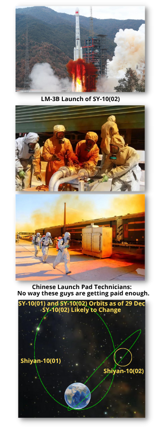
29 Dec 2022: China launched its second Highly Elliptical Orbit (HEO) satellite, the Shiyan-10(02) using a LM-3B from Xichang. Like its older sibling, Shiyan-10(01), SY-10(02) is likely to take months to reach its final orbit. Launch Video. Then there’s launch video from 200m away in 4K!
– SY-10(02) (2022-178A) is currently in a 184×40,096.5km orbit and is inclined 51°. Classic Molniya orbit is ~63+6°.
– The 63° is ‘special’, as the Earth’s flattening locks in the latitude of perigee.
– SY-10(02)’s mission is unknown. Chinese media report Shiyan-10(02) will be used for in-orbit verification of new space technologies, such as space environment monitoring.
– The US and Russia have used the ~12hr loiter over Earth’s northern latitudes for missile warning, communications and signals intelligence.
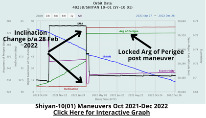
– SY-10(02)’s predecessor, SY-10(01), launched in Sep 2021 had a similar initial orbit of 177 x40104 km x 51.0°.
– Chinese media reported that the SY-10(01) launch proceeded normally, but the satellite operating conditions were abnormal. There have been no reports of anomalies with SY-10(02).
– In Oct, Chinese satellite operators raised the SY-10(01)’s perigee to 1106 x 40092km. Inclination remained at 51.1°.
-Then in late-Feb 2022 SY-10(01) conducted a large maneuver to increase inclination to 63.6°. Nine months later SY-10(01) remains at 63.7°.
– Plane changes are exceptionally expensive in fuel expenditure. To alter SJ-10 12.5° (from 51.1° to 63.6°) required ~ 400 m/s of Δv.
– After the launch, the Philippine Space Agency (PhilSA) recommended “precautionary measures related to expected unburned debris from the Long March 3B rocket” in a statement. See Video of spent Solid Boosters crashing.
– PhilSA also cautioned the public against retrieving or coming in close contact with these materials that may contain remnants of toxic substances such as rocket fuel.
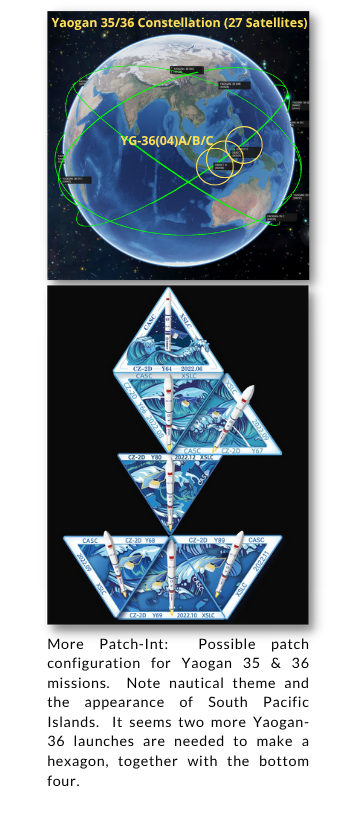
14 Dec 2022: China launched the fourth group of three Yaogan-36 satellites (YG-36(04)A/B/C) from Xichang using a LM-2D SLV. As with the previous three Yaogan 36 clusters, YG-36(04) was launched into the identical orbit of a Yaogan-35 triplet, in this case YG-36(04) is co-planar with YG-35(03) which launched on 29 Jul 2022. Launch Video.
-YG-36(04) is in the typical orbit for this constellation with an apogee of 506km, perigee of 493km and an inclination of 35°. These numbers will shift over the next few weeks as YG-36(04) maneuvers into the lead-trail-trail formation.
-As has become the pattern, YG-36(04) is plane matched with a YG-35 triplet, this time YG-35(03).
– Yaogan 36-03 is co-planar with Yaogan 35-05 satellites which launched on 6 Sep 22. Yaogan 36-01 is co-planar with Yaogan 35-01, and Yaogan 36-02 is co-planar with Yaogan 35-02.
-Two of the three satellites YG-36(04) satellites were developed by the Aerospace Dongfanghong Satellite Co., Ltd., with the third provided by the Shanghai Academy of Spaceflight Technology (SAST), both of which operate under CASC. (This is true for all YG-35 & 36 triplets).
– Few details about the satellites were disclosed by China’s government-owned media. The country’s Xinhua news agency said the satellites will be mainly used to test “new Earth-observation technology.”
– Looking at similar orbits and formations, between 2018 and 2020 China launched 8 XJS satellites with similar orbital parameters. All are 35° inclined and between 460-475km in altitude.
– Yaogan-35/36 satellites may operate in lead-trail configuration, with the lead satellite potentially cueing the two trailing vehicles.
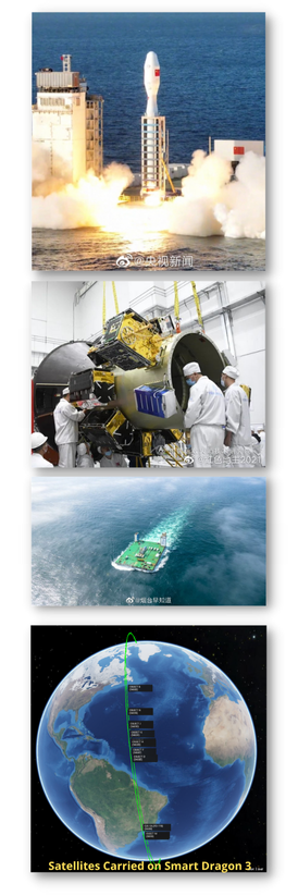
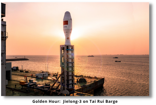
9 Dec 2022: China successfully debuted the Jielong (Smart Dragon)-3 orbital rocket from the Tai Rui Barge in the Yellow Sea. The payload for this mission was a rideshare of 14 satellites. The Jielong-3 rocket consists of four solid-fueled rocket stages and is planned to launch payloads up to to 1,500kg into Sun-synchronous orbit (SSO). The Chinese plan to use sea launch capabilities in future Yellow Sea launches. See the launch Video.
– Eight of the rideshare payloads were Jilin Gaofen (“high resolution”) satellites, seven of which were numbered 44-50. These satellites are part of a remote sensing satellite system that is operated by Chang Guang Satellite Technology, which is part of the Chinese Academy of Sciences (CAS).
– The Jilin-1 01A01 satellite will be used for different purposes, depending on the need of the constellation, and can be used for remote sensing or navigation.
– Also onboard was a satellite of the Tianqi constellation. Tianqi is used as a LEO communications satellite that will provide internet of things communications. The full constellation is planned to feature 38 LEO satellites that aim to enhance connectivity for the industry in China.
– Jielong-3 is the second rocket that has launched with the Jielong name. In Aug 2019, the Jielong-1 rocket was launched as part of a program that had the goal to enable fast and cost-efficient launch capabilities. The launch was confirmed a success, and since then, no other Jielong-1 has flown.
– Jielong 2 was cancelled in Sep 2021.
– In contrast to other solid rockets of China, such as Chang Zheng 11 (Long March 11), this rocket is not “cold launched” from the barge (see Shiyan-21 launch). For Jielong-3, the ignition happens on the barge itself. It produces 2,000 kN of thrust at liftoff. It is launched on a grid, directly over the sea, so the water of the ocean is used as a suppression system for the launch vehicle.
– Jielong-3 shares similarities with the newly debuted ZK-1A rocket, which also utilizes solid motors. Not only are the length and diameter very similar, but the rocket motor appears to be the same.
– Jielong-3 is transferred to a launch barge at its harbor in Haijang in a horizontal configuration. Later, the rocket is then raised vertically on the ship for launch. In later attempts, the plan is to carry multiple rockets and payloads on the ship when going out to sea to further increase the launch cadence of Chinese rockets. A production capacity of 20 rockets per year is planned for the Jielong rockets.
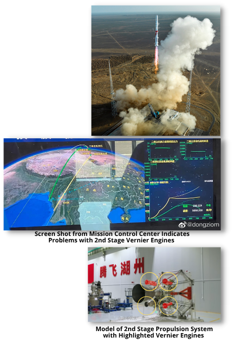
14 Dec 2022: China’s LandSpace launched the Zhuque (Redbird)-2 rocket to a Sun-synchronous orbit (SSO) from Jiuquan. The rocket failed to reach the desired orbit, falling short of orbital velocity by about 2 km/s. However, this is the first rocket in the world to make an orbital attempt with methane fuel. Launch Video. Excellent 8 min Landspace background video.
– Launch video seems to indicate that ZQ-1 performed a nominal first-stage flight and main engine cutoff (MECO). The problem occurred late in the second stage flight, during a handover point between the main engine and the four vernier engines.
– The rocket performed until about five minutes into the flight. At 5 km/s the second stage most likely suffered an issue during a shutdown and failed to accelerate the mission to orbital velocity. This is comparable to the failure that happened to the Zhuque-1 rocket in 2018.
– The payloads for the maiden launch are a variety of rideshare satellites, including a Jilin Gaofen payload. Unconfirmed reports indicate 14 payloads on the maiden
flight of Zhuque-2. With the rocket
not reaching orbit, all of the payloads reentered the atmosphere
and were lost.
-The first stage is powered by four TQ-12 methalox engines. These engines are the first in China to use methane as a fuel and the first time that methalox engines were used on an orbital attempt of a rocket.
– Other methalox rockets
under development include SpaceX’s Starship, the ULA Vulcan, Blue Origin’s New Glenn, Rocket Lab’s Neutron and Terran 1 from Relativity Space.
– For additional background on Methalox Engines please check out this Everyday Astronaut Video!
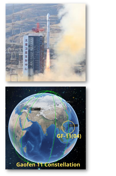
27 Dec 2022: China launched a Long March 4B from Taiyuan carrying the Gaofen-11(04) imagery satellite. GF-11(04) will three other GF-11s currently active on orbit. This satellite is believed to be in fact a military satellite series despite of having a civilian designation. It is believed, that the military designation is JianBing 16. Launch Video.
– GF-11(04) is currently in a 245 x 697km x 97.3° initial orbit. The orbit apogee will be allowed to decay over several months to 500 km and then the perigee will be raised to enter a circular 495km orbit.
-The maneuvers may take several months if previous GF-11 maneuvering is any guide. The first two GF-11/JB-16 satellites were placed in initial 250 x 693km orbits and then maneuvered to 495km circular orbits some months later.
– GF11-01 launched 31 July 2018 and achieved a circularized orbit on 10 Apr 2019; GF11-02 launched on 7 Sep 2020 and circularized by 19 Mar 2021.
– All GF-11 satellites have launched on a Long March 4B from Taiyuan. GF-11(01) was launched on 31 Jul 2018; GF-11(02) launched on 7 Sep 2020; GF-11-03 launched 11 Nov 2021.
– Typical of imagery satellites, all GF-11 satellites are in a sun-synchronous orbit.
– Gaofen 11 satellites likely form the optical high-resolution component of the state-sponsored China High-definition Earth Observation System (CHEOS) constellation. CHEOS is unrelated to the smaller commercial Jilin-1 Gaofen satellites.
– Open Source analysis from 2018 estimated GF-11’s mirror size at 1.7m. A mirror of this size equates to a ground resolution of 8-10cm at perigee (~247km). At an average altitude of 470km, the resolution is still 15-20cm, surpassing all commercial and most reconnaissance satellites. This propels China into the select club of countries that can acquire NIIRS 8-9 satellite imagery, meaning the resolution is high enough to identify small hand-held weapons.
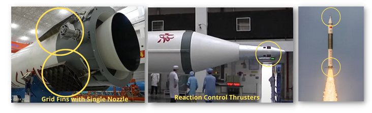
7 Dec 2022: Expace, a private Chinese rocket company, had its first successful launch of its Kuaizhou-11 (KZ-11) rocket. The rocket lifted off from the Jiuquan Satellite Launch Center and carried the VHF Data Exchange System (VDES) test satellite into orbit. Expace is a commercial spinoff from the China Aerospace Science and Industry Corporation (CASIC), a state-owned defense giant. Launch Video.
– The Kuaizhou-11 rocket can carry 2,220lbs (1000kg) of payload to SSO or up to 3,300lbs (1500 kg) to low Earth orbit, making it five times more powerful than the smaller Kuaizhou 1A.
– KZ-11 is believed to be derived from the Dongfeng-31 (DF-31) missile. It is the second largest solid rocket built in China. The rocket body uses carbon fiber composite case to reduce weight.
– The first KZ-11 launch took place in Jul 2020 but ended in failure. Expace also suffered an explosion during testing at the Jiuquan spaceport, which may have been a factor in the two-year grounding of the rocket.
– The KZ-11 appears to have unconventional attitude control system. The first stage has a fixed nozzle with four grid fins around the base of the rocket helping to keep it steady during its ascent through the atmosphere. A module containing reaction control thrusters was mounted atop the payload fairing to steer the vehicle.
-The VDES satellite is in a 744.3 x 757.0km 98.4 ° sun-synchronous orbit (SSO).
– The satellite carries VDES and automatic identification system (AIS) payloads for maritime-related uses and is part of the “Xingyun” 80-satellite narrowband constellation.
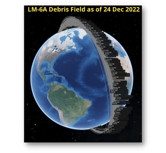
Trashing the Neighborhood: LM-6A Debris Now 300+
Latest tracking information shows there are now 350 pieces of debris associated with the LM-6A upper stage break up event. China Launched the LM-6A on 12 Nov 2022 with the Yunhai-3 Satellite. Debris perigee ranges from 320 to 844km.
– The Chinese government confirmed the rocket break up.
– The rocket’s upper stage is intended to fall back toward Earth’s atmosphere in one piece, before burning up during reentry.
– It is unclear what caused the rocket to break up.
– This was only the second launch of the Long March 6A, a version of the Long March 6 rocket with four solid rocket boosters.
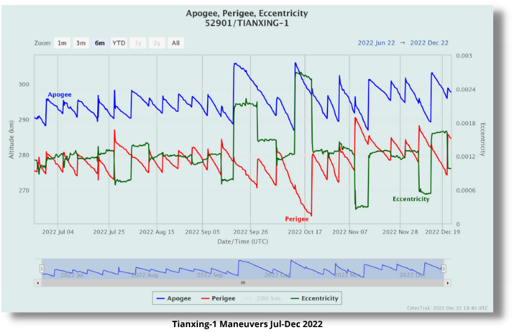
Busy Bee: The Strange Orbital Maneuvers of Tianxing-1
Upon arrival on-orbit on 23 Jun 2022, the Tianxing-1 satellite has repeatedly altered its perigee, apogee and eccentricity. Conducting frequent and large maneuvers is highly irregular. Very little is known about the Tianxing-1 satellite; according to Chinese space authorities and media the satellite is said to be used for experiments including “space environment detection.” It is possible Tianxing-1 is maneuvering to observe other space objects, collecting space environment data from different altitudes or supporting some other experiment.
– In previous US Rendezvous missions phasing orbits were used extensively to slide back, pull up to either a point in space or a target.
– Tianxing-1 mission controllers might be adjusting the satellite’s orbit period via apogee and perigee changes to set up a intercept of some sorts, maybe observe another object or conduct a non coplanar drive by.
– Until now, most of China’s RPOs have been coplanar (see Table 3-1 in SWF Counterspace Capabilities Report.)
-Again, there is no evidence Tianxing-1 is conducting RPO, the hypothesis above is based on potential motivations for Tianxing-1’s orbital behavior.
Editors Note: Special thanks to Dr TS Kelso for bringing Tianxing-1 to my attention. Additional thanks to Jack Anthony and others for offering their interpretation of what the maneuvers might indicate.

23 Dec 2022: Sandra Erwin and Debra Werner released an article in SpaceNews which examines how Russia’s invasion of Ukraine set in motion a realignment with near, medium and long-term implications, casting dark clouds over the global space community but also revealing some silver linings. One particular silver lining is that nations around the world, taking note of the commercial contributions, have backed domestic space startups and forged relationships with existing satellite service providers.
Overall satellites coupled with NATO weapons systems helped Ukraine mount a formidable defense. On the diplomatic side, public dissemination of satellite imagery has stymied Russian disinformation operations and helped document war crimes and atrocities.
1. STRANDED SATELLITES: The war has been catastrophic to the Russian space launch industry. The International Space Station is one of the few Russian-involved international endeavors to carry on business-as-usual post invasion. Other civil and commercial space programs haven’t fared as well. OneWeb and numerous ESA missions found alternate launch providers in the US and India. Before the Russian invasion, ESA and Roscosmos planned a trio of lunar exploration missions, which have been scrapped. The war and Western sanctions forced nations to choose between partnering with the West or Russia. Lacking western partners, Russia has more closely aligned with China and forged a pact with Iran that led to the August launch of an Iranian remote-sensing satellite on a Soyuz rocket.
2. EUROPE’S WAKE UP CALL: ESA, the European Union and individual nations have spent the last 10 months dismantling programs with Russian involvement and fostering domestic capabilities. ESA member states approved a 16.9 billion euro budget ($17.5 billion) over three years at the Ministerial Council Meeting in Nov, about 16.6 percent more than the spending plan approved in 2019.
3. SATELLITES IN THE CROSSHAIRS: After Starlink proved so valuable to the Ukrainian armed forces, Russian officials stated they would consider the constellation a military target. Commercial remote sensing satellites that tracked Russia’s pre-invasion moves and galvanized the West in support of Ukraine also have drawn Putin’s ire.
4. IMAGERY ANALYSIS GOES MAINSTREAM: Maxar’s news bureau started monitoring the buildup of Russian forces and hardware along the Ukrainian border months before the invasion started in Feb 2022. Maxar’s bureau staff and news organizations every day aggregate and analyze thousands of images to identify newsworthy activities happening in Ukraine, including revelations of war crimes and human rights violations. The Ukraine war cemented the role of the news bureau in promoting global transparency and combatting the spread of disinformation.

5. COMMERCIAL SPY SATELLITES SHINE: Companies like BlackSky and Planet followed in Maxar’s footsteps providing electro-optical imagery to the news media. Commercial synthetic aperture radar imagery from Capella Space and Iceye has seen higher demand, as radar penetrated heavy cloud coverage over Ukraine. Radio-frequency data providers like HawkEye 360 and Spire Global used satellites to track Russian GPS jammers.
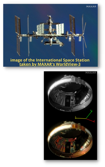
5 Dec 2022: The National Oceanic and Atmospheric Administration (NOAA) modified Maxar’s remote sensing license to enable the non-Earth imaging (NEI) capability for its current constellation on orbit as well as its next-generation WorldView Legion satellites.
– Maxar can collect and distribute images of space objects across the Low Earth Orbit (LEO)—the area ranging from 200-11,000km in altitude—to government and commercial customers.
– Maxar’s constellation is capable of imaging objects at less than 6 inch resolution at these altitudes, and can also support tracking of objects across a much wider volume of space.
– These capabilities can provide customers with accurate information to assist with mission operations
and help address important Space Domain Awareness (SDA) and Space Traffic Management (STM) needs.
– Maxar will begin deploying its NEI capability in 2023 with a select group of early adopters to understand and characterize space objects at scale.
– Maxar has some experience with satellite-to-satellite (Sat Squared) imagery. After its WorldView-2 imaging satellite was hit by a non-tracked piece of debris the company used one of its other satellites to image WorldView-2 and determine the damage was minimal. The satellite remained operational after the event.
Perhaps we’re not too far off from receiving high-resolution and unclassified
imagery of a large number of LEO objects. As it has with earth remote-sensing imagery this could spawn commercial analysis centers at places such as Middlesex University of London and lead to a much greater understanding of missions/capabilities of LEO objects. With the addition of video collection this capability could also be very useful in debris capture/removal operations as well.
5. COMMERCIAL SPY SATELLITES SHINE: Companies like BlackSky and Planet followed in Maxar’s footsteps providing electro-optical imagery to the news media. Commercial synthetic aperture radar imagery from Capella Space and Iceye has seen higher demand, as radar penetrated heavy cloud coverage over Ukraine. Radio-frequency data providers like HawkEye 360 and Spire Global used satellites to track Russian GPS jammers.
13 Dec 2022: During their visit to the United States as part of the US-Africa Leaders Summit, Nigeria and Rwanda signed the Artemis Accords. They were the 22nd and 23rd nations to do so.
– The Summit featured the first-ever U.S.-Africa Space Forum where Participants committed to deepening the U.S.-Africa space partnership across all sectors.
– Nigeria and Rwanda became the first African nations to sign the Artemis Accords.
– Signatories commit to principles to guide their civil space activities, including the public release of scientific data, responsible debris mitigation, registration of space objects, and the establishment and implementation of interoperability standards.
5. COMMERCIAL SPY SATELLITES SHINE: Companies like BlackSky and Planet followed in Maxar’s footsteps providing electro-optical imagery to the news media. Commercial synthetic aperture radar imagery from Capella Space and Iceye has seen higher demand, as radar penetrated heavy cloud coverage over Ukraine. Radio-frequency data providers like HawkEye 360 and Spire Global used satellites to track Russian GPS jammers.
9 Dec 2022: Xi Jinping announced that China plans to cooperate with Saudi Arabia and other Gulf countries in the fields of nuclear energy, nuclear security and space exploration. The six Gulf Cooperation Council countries consist of Bahrain, Kuwait, Oman, Qatar, Saudi Arabia, and the United Arab Emirates.
– China wants closer cooperation with the Gulf countries in the fields
of space exploration and infrastructure.
– China and the Gulf States are discussing establishing a shared center for moon and deep space exploration and China will assist the Gulf States in training their own astronauts, who will be welcomed on

China’s space station to work with Chinese astronauts and to conduct scientific experiments.
– China is offering to: 1) Train astronauts to conduct research on China Space Station; 2) Rideshare Chinese launches; 3) Establish China-Gulf Countries Lunar and Deep Space Exploration Center; 4) Remote sensing and communication support; and 5) Access to facilities to support space exploration
– Space is an area of particular interest for Crown Prince Mohammed bin Salman, the 37-year-old de facto ruler of Saudi Arabia, an avid science-fiction fan who set up the kingdom’s first space commission in 2018.
China is a “rising power” with great economic and technological capabilities, and Arab countries want to benefit from that, said Arab League Secretary-General Ahmed Aboul Gheit. “Especially,” he added, “because they don’t offer it to you with conditions.”

5 Dec 2022: Article in the Space Review in which author Donatas Palavenis, a Junior Officer in the Lithuanian armed forces and junior researcher at the Baltic Institute of Advanced Technology (BPTI), discusses the growing capabilities and importance of small satellites (<500kg) for national defense and the role they could play for small nations.
– Small satellites seem to be conquering space at
an extraordinary rate today…at least 1,800 small satellites will be launched per year in the future.
– Small satellites are focused on performing a single function while large satellites may contain
many complex sensors.
– Small satellites are often launched in clusters, so the area covered by them can be equal to the area covered by a large satellite.
– It is possible to create clusters of small satellites or a group of linked satellites that have different sensors that fly over the same point on the ground at the same time, allowing different types of data to be combined.
– Several small satellites can provide identical or more detailed information than large satellites.
– Smallsat clusters can consist of over more than 100 satellites, increasing revisit frequency
– Smallsats make it possible to quickly replace

satellites in orbit, launch new ones for specific tasks, restore damaged ones, or increase the quantity in a certain orbit to increase the observation time.
– The US military is currently testing the use of small satellites through the Convergence experimental project, where the capabilities of commercial and government-operated satellites have been used to photograph the battlefield and rapidly exchange information with the help of communications satellites.
– The addition of data synthesis and artificial intelligence capabilities shortened the decision-making speed—from target identification to firing a shot—from 20 minutes to 20 seconds.
– Clusters of small satellites provide another important advantage: resistance to kinetic attacks like anti-satellite weapons.
– For a small state, it is important to properly assess the amount of information required for national security. Small states must also assess what type of sensors are most effective, the optimal number of small satellites, their orbits, and other important parameters. t in the case of a small state, the solution would be: to have several state-owned satellites (e.g. the case of Albania) and, in case of need, to be ready to order the data of the required areas from foreign companies or other states.
– Notably, no commercial small satellite cluster company has yet proven to be commercially viable without government support.
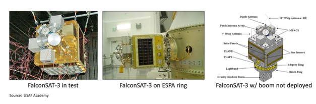
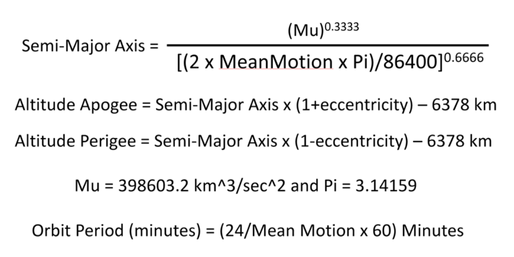
Jack's Astro Corner: Reader Challenge FalconSat-3 Decay Monitoring Mission
YOUR MISSION — MONITOR THE DECAY OF FALCONSAT-3
Here’s a chance for you, your family or friends to experience being in a Space Operations Center monitoring an important on-orbit event playing out in December and January, maybe extending into February. It’s a mission to monitor the decay and re-entry of the USAF Academy’s FalconSAT-3 spacecraft. It’s been on-orbit for almost 16 years and has been slowly getting closer and closer to Earth and will soon (1-2 months?) enter the earth’s atmosphere and burn up. Interested in taking on this mission? Hope so!
REVIEW OF WHAT LIES AHEAD IN THIS ARTICLE TO ENABLE YOU TO DO THIS MISSION
First, I’ll introduce you to the USAF Academy’s FalconSAT-3 satellite, mission and crew force. It’s an amazing story involving more than 1000 cadets, staff and many dignitaries who got to operate FalconSAT-3. Secondly, I’ll review how to get the FalconSAT-3 orbit element set data each day (or every 2-3 days, you decide your “ops tempo”). I recommend you visit Celestrak.org as your source for the FalconSAT-3 TLE (Two-Line Element Set). I’ll explain how. Thirdly, and maybe the most “fun” part of preparing for your mission, is developing your own mission software that YOU will create on an MS Excel spreadsheet. I provide you the equations. If you are good with spreadsheets, that will be easy. If not, here is a chance to learn and have fun and create astrodynamics capability to analyze a satellite’s orbit decay. Find someone who knows how to use a spreadsheet to solve equations and they can help you. If you want to skip this “develop your software” step, you can ask me to send you a nifty spreadsheet I made. Lastly, getting underway. You and your crew can get the FalconSAT-3 TLE daily (or every 2-3 days, you decide your tempo) and get the data items you need (there’s 2) and run your mission software tool to get 4 parameters that give insight into the FalconSAT-3 decay: the FalconSAT-3’s orbit semi-major axis, orbital period, and the altitudes of perigee and apogee. You can plot these on graph paper or using Excel to make plots. Maybe just mark these indicators of decay progress on your calendar. How low will FalconSAT go before is plummets into the Earth’s atmosphere? You will find out! If you want me to send you a mission spreadsheet tool I made, send me an email at jack.anthony@integrityisr.com. Better yet, if you decided to tackle this mission, send me an email and I’ll make sure to email you any updates or other helpful hints.
FALCONSAT-3 SATELLITE, MISSION AND CADET CREW FORCE
FalconSAT-3 was built by the cadets and Space Systems Research Center (SSRC) staff at the USAF Academy 2002-2006. The AF Research Lab is the primary sponsor and benefactor of the Academy’s FalconSAT program. Their cadets and SSRC are the “go to” team for AFRL. FalconSAT-3 is a 119lbs (54kg) small spacecraft hosting several experiments including two space environment sensors developed by the Physics Department and an AFRL sponsored Micro Propulsion Attitude Control System that earned a patent. The main body of the satellite is the size of a college dorm refrigerator. FalconSAT-3 also has a 10-ft gravity gradient boom that was deployed. It has a small mass at the end of
the boom. The FalconSAT satellite control center is on the AF Academy and is staffed by the Cadet Satellite Operations Squadron. Today they operate two FalconSATs on orbit. FalconSAT-3 was launched 9 March 2007 on an AF Space Test Program sponsored Atlas V. It was placed in a 560 Km orbit at an inclination of 35 degrees. Many satellites ventured into space on this STP-1 mission including the DARPA Orbit Express on-orbit servicing space experiment. From early April 2007 when the spacecraft was fully up and running to Sep 2017, FalconSAT-3 conducted many experiments and most of all it gave the cadets a “learn space by doing space” experience in operating the spacecraft. During this first 10 years, FalconSAT-3 was also operated by guest operators who were given the equipment to contact FalconSAT-3 from their locations. These include the US Military Academy at West Point, the Undergraduate Space Training class at Vandenberg AFB, and the AF Institute of Technology. The hands-on experience of planning, executing, and assessing the space experiment data gave the cadets and guest operators a unique experience that prepared many of them to serve in AFSPC and now USSF. Maybe you have participated as a FalconSAT satellite operator! In September 2017, the AMSAT (Radio Amateur Satellite Corporation) took over the operations of FalconSAT-3 where it serves as an on-orbit store and forward satellite, keeping very busy supporting world-wide HAM radio operators. At the time of this writing, FalconSAT-3 was at about 300 Km altitude and starting to accelerate its demise via entry into the Earth’s atmosphere. For nearly 16 years, the mighty FalconSAT-3 kept on keeping on and the cadets and HAM radio enthusiasts have benefitted greatly from it. Here’s some photographs and an illustration of the FalconSAT-3.
GETTING FALCONSAT-3 ORBIT ELEMENT DATA…the 30776 TLE
OK, now we need to develop a way to get the FalconSAT-3 orbital element set each day (or every 2-3 days, your choice). That’s easy. You can go to Celestrak.Org and access their database to get the 30776 TLE. It’s easy and there is a lot of great info on Celestrak.Org. One method is click on “Active Satellites” and that will open list of the TLEs for all the satellites on orbit that are still working. Scroll down to find “FalconSAT-3” which will have the 30776 element set number. These two lines are the TLE for FalconSAT-3. Then get the data you need. There are two things you need to get from the TLE: FalconSAT-3’s Mean Motion and Eccentricity. Here’s the 30776 TLE for 17 Dec 2022. I underlined the eccentricity (remember to put a decimal point in front of it when you use it in the equations) and the Mean Motion:
1 30776U 07006E 22351.78846701 .00225463 00000-0 10500-2 0 9990
2 30776 35.4231 122.1357 0007224 46.2153 313.9185 15.81697392878284
Here’s another super easy way to get the 30776 TLE. This web link below will display the TLE. I encourage you to dive into Celestrak.Org, lots of cool astro stuff. Here’s the link.
DEVELOPING YOUR MISSION SOFTWARE ON MS EXCEL
Ok, so how do you develop (or get from me) your Mission Software? Let’s call it Orbit Monitoring Tool. You’ll need MS Excel to create your spreadsheet. I encourage you to make your own tool, become an astrodynamics rockstar in your family, neighborhood or at work. Imagine telling your boss or your mom or dad “why yes, I develop and write astro code for real world space use,” YOU will impress everyone…no kidding!
From the FalconSAT-3 TLE, we will be getting the Mean Motion of FalconSAT-3 and the eccentricity (shape) of the orbit. As you remember, Mean Motion is in revs/day, how many orbits FalconSAT-3 makes in a 24-hour day. Within this parameter is the size of the orbit, the semi-major axis. That’s the mean altitude over an orbit. The eccentricity will enable us to calculate the altitude of perigee (closest) and apogee, furthest away. We’ll assume a spherical Earth.
Here below are the equations to calculate the semi-major axis of the orbit in Km, orbit period in minutes, as well as the altitudes of apogee and perigee. If you are confident in your MS Excel spreadsheet equation skills you can code this up and have your tool ready for operations. Make it spiffy! If you are new to Excel, find a person to help you, maybe a kid, they know this stuff! Another option that is AOK to use is send me an email and say “Jack, send me your Orbit Monitoring Tool.” I encourage you to try to learn this spreadsheet equation skill or have someone (your kid) help you…it will empower you to be numerically agile and awesome. But again, I can send you what you need to get underway, happy to do so. Here’s the equations:
the FalconSAT-3 spaceship is within a few days of burning in. Maybe pick up the tempo of monitoring the TLE to daily. There are many variables, mostly due to the Sun’s activity and how it effects the atmosphere and the FalconSAT-3’s orientation as it “hits the atmosphere.” Things like Solar Storms affect the atmosphere density “way out there.” Plus, there’s always modelling uncertainties. It’s the nature of our astro business. When the FalconSAT-3 decays, the TLE will no longer be updated. You’ll have great data to make your assessment of what altitude it came in. Kerplunk…it quits orbiting and flutters down in a fiery breakup. Not sure where until after and most burns up. Good luck with your mission and most of all involve your family, friends, co-workers. Have fun with astro!
Again, here’s my email: jack.anthony@integrityisr.com. Send me an email letting me know you are going to give this mission a try. Also, if you want me to supply you my mission software spreadsheet I created, I am happy to send it to you for your use. If in giving this mission a try you have questions, send me an email. I’ll help. This will be fun, that’s an order…LOL.