issue 24 | 20 June 2021
The integrity flash
Analysis of Developments in the Space Domain
in this issue
10 June 2021: US Media reports Russia is preparing to supply Iran with an advanced satellite system that will give Tehran an unprecedented ability to track potential military targets across the Middle East and beyond. Russian President Vladimir Putin dismissed the report as “garbage.”
– The reported plan would deliver to the Iranians a Russian-made Kanopus-V satellite equipped with a high-resolution camera that would greatly enhance Iran’s spying capabilities, allowing continuous monitoring of facilities ranging from Persian Gulf oil refineries and Israeli military bases to Iraqi barracks that house U.S. troops.
– Russia has not established a launch date for Kanopus-V. A launch could happen within months.
– Iran’s new satellite would be launched in Russia and would feature Russian hardware, including a camera with a resolution of 1.2 meters
– Iran would be able to “task” the new satellite to spy on locations of its choosing.
– Iranian military officials have been heavily involved in the acquisition, and leaders of Iran’s elite Islamic Revolutionary Guard Corps have made multiple trips to Russia since 2018 to help negotiate the terms of the agreement.
– Russian trainers have helped ground crews who would operate the satellite from a new site near the northern Iranian city of Karaj.
– If fully realized, the deal with Russia would represent a significant boost for an Iranian military establishment that has struggled in its own attempts to put a military reconnaissance satellite into orbit.
– As far back as 2015, Iran’s Press TV news service reported that Iranian and Russian companies had entered an arrangement that would allow Iran to acquire a “remote-sensing system which can be employed for collecting information about the Earth’s surface, atmosphere and oceans.”
– Vladimir Putin responded to the report by saying, “It’s just fake news. At the very least, I don’t know anything about this kind of thing, those who are speaking about it probably will maybe know more about it. It’s just nonsense, garbage.”
– Previously Iran used commercial satellite images to monitor Ain al-Asad Air Base in Iraq as it prepared to launch more than a dozen ballistic missiles at U.S. and coalition forces. See VIDEO from 60 Minutes.
– Awareness of Iranian commercial imagery purchases allowed US forces to relocate potential targets such as aircraft. Control of a Kanopus-V would enable Iran to conduct surveillance and target development with increased operational security.
“Having this kind of on-call data feed may open up technical and operational possibilities that the Iranians previously didn’t have,” said Christopher Ford, the State Department’s top nonproliferation official under the Trump administration. “It sounds like a significant upgrade, not just a slight slide up the slope in terms of potential military applications.”

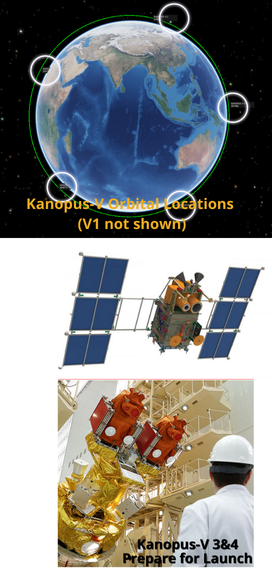
Kanopus is a constellation of small remote sensing spacecraft that operate alongside the larger Resurs satellites to form Russia’s primary civilian Earth observation system. Both Resurs and Kanopus have some overlap with the military and will be called upon when necessary to deliver data for defense ministry purposes.
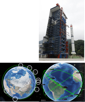
– There are currently 6 active Kanopus-V satellites in orbit. All but one, the Kanopus-V1, are in the same orbital plane. They operate in a sun-synchronous orbit (513km with 97.4 ° inclination.)
– The first Kanopus-V (Kanopus Vulkan) satellite was launched in July 2012 and has a ground resolution of 2.5m. It was followed by Kanopus V-IK which was delayed six years to facilitate the addition of the MSU-IK-SRM infrared-sensing instrument for hot-spot and fire detection. (IK being an abbreviation for Infra-Krasny which translates to “infrared”).
– Kanopus-V 3 & 4 satellites were launched side-by-side atop a Soyuz rocket in 2018 from Russia’s Vostochny –Cosmodrome and were followed by the Kanopus-V 5 and 6 pair also launched in 2018.
– Each weighs in at 490 Kilograms and hosts a payload of 106 kgs.
– The satellite platform supports precise pointing with an attitude stability of 0.001 degrees per second and a pointing accuracy of 5 arcmin. Imaging at off-nadir angles up to +/-40 degrees can be supported, requiring 2 minutes for a slew from –40° to +40° off-nadir, allowing the satellite to conduct agile imaging operations with quick re-targeting.
– An onboard GNSS navigation receiver provides the satellite’s position with an accuracy of 15 meters for proper geo-tagging of acquired imagery.
– The Kanopus satellites have an onboard memory of 24 gigabytes; data downlink is accomplished using an X-Band communications system operating between 8.048 and 8.382 GHz and achieving data rates up to 122.8 Megabits per second.
The Kanopus Program is operated by Roscosmos and data users include the Ministry of the Russian Federation for Civil Defense, Emergencies and Elimination of Consequences of Natural Disasters, Ministry of Natural Resources of the Russian Federation, the Federal Service for Hydrometeorology and Environmental Monitoring, and the Russian Academy of Sciences.
– According to VNIIEM (the Kanopus-V manufacturer), the Kanopus-V satellites are largely identical with no significant changes from the satellite launched in 2012 to the satellites launching in 2018 in terms of platform design as well as instrument capabilities.
10 Jun 2021: China launched four spacecraft aboard a Long March 2D rocket from Taiyuan Satellite Launch Center in north China. Among the payloads was the Beijing-3, a remote-sensing satellite that will be operated by Twenty First Century Aerospace Technology Co., Ltd (21AT), a commercial space company.
– Very little is known about the Beijing-3 satellite, other than it is a 0.5 m resolution Earth observation satellite being delivered to Sun-Synchronous Orbit (SSO).
– The satellite is based on the CAST3000E agile satellite platform, which uses high agility, stability, and precision technology and on-orbit image processing to produce high-quality and high resolution images of Earth.
– China launched the Beijing-1 and Beijing-2 missions in 2005 and 2011, respectively. They provided the Chinese government and other companies with information on agriculture, urban development, pollution, water resources, and environment and disaster monitoring Beijing-3 can provide a large number of high-resolution remote sensing satellite data and information products for the global market. It is advertised to be capable of obtaining resolution 0.5 meters resolution and Multi-spectrum resolution of 2.0 meters.

17 Jun 2021: China launched its 9th group of classified Yaogan-30 satellites and one commercial satellite on a Long March 2C rocket.
– Yaogan series satellites are perceived by outside analysts to be designated for military purposes. The inclination of the Yaogan-30 constellation suggests it may provide frequent revisits for electronic and signals intelligence and optical and radar imaging in areas close to China.
– As with previous Yaogan-30 launches the new satellites were placed into roughly circular, 600-kilometer altitude orbits inclined by 35°.
– The Yaogan-30 constellation now consists of 27 satellites and uses 6 orbital planes. The new satellites join 6 others (Yaogan-30 G/H/K/J/L/M) in the orbital plane with a RAAN of 326.4°. This particular orbital plane is now the most populated in the Yaogan-30 constellation (others have either 3 or 6 satellites).
China has created a Yaogan 30 satellite constellation of six equally-spaced planes. With their 35° inclination, Yaogan 30 satellites are optimized to look at countries close to China, especially on the Pacific coast.
Physics of Space War Report & Video
In October 2020, the Aerospace Corporation published a report describing how physics constrains space-to-space engagements of a conflict. The paper lays out five key concepts: satellites move quickly, satellites move predictably, space is big, timing is everything, and satellites maneuver slowly.
– Space-to-space engagements in a modern conflict would be fought
solely with un-crewed vehicles controlled by operators on the ground and heavily constrained by the limits physics.
– Space-to-space engagements would be deliberate and likely unfold
slowly because space is big and spacecraft can escape their predictable paths only with great effort
– To “control space” is not necessarily to physically conquer sectors of space but rather to reduce or eliminate adversary satellite capabilities while ensuring one retains the ability to freely operate their own space capabilities.
– Satellites Move Quickly but Predictably: Objects orbiting Earth have a strict relationship between altitude and speed. Objects at lower altitudes will always move more quickly than those at higher altitudes. The relationship between altitude, speed, and orbit shape makes satellite paths predictable.
– Space is Big: changing or repositioning a satellite in its orbit, known as a maneuver, can require significant time and energy. Due to the distances involved, planning for a kinetic satellite attack requires accounting for both the time and ΔV needed to execute the mission. Operators may spend weeks moving a satellite into an attack position.
– Timing is Everything: getting two satellites in the same spot is not intuitive. Therefore, it requires careful planning and perfect timing. Plane matching is crucial, if an attacker matches planes with a target it has the
initiative and can dictate when an engagement occurs. Once an orbital threat has matched planes and set up the timing through precise orbital phasing, many opportunities can arise to maneuver close enough to engage a target quickly.
– Satellites Maneuver Slowly: Because space is so big, catching up to a target takes careful planning and a long time to execute. Maneuver in LEO is bounded: If a satellite performs a forward phasing maneuver with a first burn of 115 m/s or more of ΔV, it will reenter Earth’s atmosphere and burn up. Similarly, if a satellite performs a backward phasing maneuver with a first burn of 350 m/s or more of ΔV, it will experience high radiation in the Van Allen belts. These two facts create natural bounds for how quickly a satellite can maneuver in LEO (500 km or 310 mi.)
– Types of Kinetic Engagements: ground-based anti-satellite (ASAT) missiles, and on-orbit weapons
— Ground Based: Unlike orbital ASATs, it does not require extensive setup time to be operational—if the
target is within range, the missile can be used. Flyout times can be less than 10 minutes to LEO and less
than 5 hours to GEO, leaving the target little time to detect and react to an attack.
— Co-Orbital: may be launched months to years ahead of a potential conflict. Can more readily pursue a
maneuvering target than can a rapidly approaching ASAT missile.
– Electronic Warfare, Directed Energy, and Cyberattacks: threats utilizing the electromagnetic spectrum to
inflict either temporary (reversible) or permanent (irreversible) harm.
— Electronic Warfare: using radio frequencies to overwhelm an opponent’s signals with random noise
(jamming) and the purposeful mimicking of signals to send harmful commands or data (spoofing).
— Directed Energy Weapons: Can be either reversible or nonreversible. High-power microwaves interfere
with onboard electronics, with effects ranging from temporary malfunctioning to melting of critical
components and other permanent damage.
— Cyber: Target the data used and transmitted by a satellite. Can either target ground stations or target
the satellite directly. A cyberattack on a satellite can result in loss of information needed to perform its
mission, or even loss of control of the vehicle itself.

Commercial Space: Transporter-2 Launch Contains Cluster 3 Hawkeye 360 Satellites
20 Jun 2021: SpaceX’s Transporter 2 launch is scheduled for 25 June 2021. On board will be three satellites from Hawekeye 360, the first commercial company to use formation-flying satellites to create a new class of radio frequency (RF) data and data analytics.
– Transporter 2 will contain “Cluster 3” a trio of HawkEye 360 2nd generation satellites, each with an RF payload
– Cluster 3 will join HawkEye 360’s Cluster 2 and the Cluster 1 Pathfinder satellites on orbit, further expanding the company’s baseline constellation.
– The newest satellites will significantly expand the constellation’s collection capacity and reduce revisit rates.
– Seven additional next-generation clusters — fully funded and scheduled for launch in 2021 and 2022 — will complete the baseline constellation, enabling revisit rates as rapid as 20 minutes to support time-sensitive defense, security and commercial applications.
– Cluster 2 was launched in January 2021 as part of the Transporter 1 mission. Cluster 2 processes data at a faster rate than the pathfinder Cluster 1 and is equipped with improved software-defined radios (SDR) that can simultaneously collect a wide range of frequencies.
– The overall system is designed to produce faster, and more accurate geolocations.
– Cluster 3 includes capabilities to perform on-orbit investigations which will help shape a roadmap for future feature additions.
Hawkeye’s clusters of small satellites detect RF emissions from about 500 kilometers up, and are able to geolocate the wireless transmitters. They deliver that data to governments and private parties for such uses as defense programs, wildlife protection, and maritime applications.
The company’s satellites, each about the size of a large microwave with wings, have already been able to monitor Chinese military buildups at their border with India, and potential illegal fishing and poaching activities in Congo and around the Galapagos Islands. See VIDEO.
In September 2020 the US National Geospatial-Intelligence Agency (NGA) began importing HawkEye 360 unclassified data.

