issue 25 | 4 July 2021
The integrity flash
Analysis of Developments in the Space Domain
in this issue
22 June 2021: US Media reports a failed Iranian space launch occurred on 12 June 2021. The US Space Command confirmed the attempt. A variety of commercial imagery satellites provided open source indications and warning in the days leading up to the launch. Another launch attempt may be imminent.
– Jeffrey Lewis, a professor at the Middlebury Institute of International Studies, said it was likely the Simorgh rocket is a two-stage space launch vehicle using engines based on a North Korean design.
– “The failed launch attempt is the fourth consecutive failure of the Simorgh launcher,” said Lewis, author of an upcoming book on Iran’s space program. “Iran seems to be struggling with this specific system. Other Iranian rockets of different designs have been more successful.”
Critics of Iran see the satellite launches as a provocative step, since the rockets use technology similar to what is needed for intercontinental ballistic missiles (ICBMs). “The Iranians have a long history of conflating the commercial and the military,” said Bradley Bowman, senior director at the Center on Military and Political Power at the hawkish Foundation for Defense of Democracies think tank. “Anything that Iran is doing in space I would be concerned about, because they are going to…use those same capabilities against us in a military conflict.”
– The June 12 launch attempt comes over one year after the country’s last attempt to put a satellite into orbit. In April 2020, Iran launched the Nour 01 military satellite into orbit after previous failed attempts to launch similar satellites. This move that revealed a military aspect to the country’s civil space program.
– Open source analysts first noted launch preparations on 6 June from an @Maxar image of the Imam Khomeini Spaceport which are normally associated with Iranian space launches.
– On June 6, there were more than a dozen vehicles at the horizontal checkout building — something that only happens before space launches and a normal indicator.
– Another pre-launch signature is specialized equipment at the mobile launch gantry including two specific vehicles and a mobile work platform that were present on the 6th.
– Given the indicators discovered on 6 June, analysts re-examined 1 June imagery from @planet and saw fuel containers, as well as a possible oxidizer container.
– On 20 June @planet imaged the site again. A support vehicle and the mobile work platform are back at the gantry and there is another load of fuel (and possibly oxidizer) on site.
– Additional @planet imagery seems to reveal scarring at the launch site that occurred between 18-23 June. There has been no additional reporting of a launch occurring after the 12 June attempt.

25 June 2021: Russia launched the Pion-NKS, a long-delayed ELINT & radar-imagery spacecraft believed to be capable of guiding Russian Navy missiles to their targets. A Soyuz-2-1b rocket lifted off as scheduled at 22:50 Moscow Time (3:50 p.m. EDT) from Plesetsk Cosmodrome, north of Moscow.
– The Pion-NKS satellite was built as part of the Liana electronic-intelligence network operated by the Russian military and serving both ground and naval forces.
– As of 2021, the constellation five Lotos spacecraft equipped with radio-intercept sensors in orbit.
– Pion-NKS should introduce a major new capability to the system, adding an imaging radar intended for pinpointing potential targets around the world for the Russian Navy independent of weather and lighting conditions.
– While Lotos first reached orbit in 2009, the Pion sub-system remained grounded for another decade due to problems with the development of its main payload.
– The radar aboard Pion-NKS is apparently intended primarily for imaging sea vessels. Operating in concert with radio-intercepting sensors, the radar would greatly enhance the locating and identification of sea-based targets.
– According to Russian press, the breakdown of Ukrainian industrial cooperation in 2014 and subsequent western sanctions severely delayed of the Pion-NKS project.
– As with previous Lotos missions, the Pion-NKS spacecraft was tracked in a 195 by 466-kilometer initial orbit with an inclination 67.1 degrees toward the Equator. Pion-NKS later fired its engine near apogee (the highest point) to make the orbit circular at an altitude of around 460 kilometers.


21 Jun 2021: In a follow up to the Washington Post article regarding Russia providing Iran with a Kanopus-V earth observation satellite, Bart Hendryx in the Space Review writes, “the existence of the Russian-Iranian remote sensing satellite project has been a well-established fact for several years.”
– Russia and Iran publicly disclosed their intention to pursue this joint program in 2015. The Post quoted Iran’s Press TV news service, which listed the Russian partners as NPK Barl, a manufacturer of satellite ground support systems; and VNIIEM (All-Russian Scientific Research Institute of Electromechanics), a builder of meteorological and remote sensing satellites. They would team with the Iranian state-operated trade company Bonyan Danesh Shargh and the Iranian Space Agency.
– Pre-contractual agreements between the three parties took place in Aug 2015, at the bi-annual MAKS aerospace show in Zhukovskiy outside Moscow. The signing ceremony was widely covered in the Russian media. NPK Barl was given the lead role in the project and be responsible for integrating and finishing the ground-based infrastructure, VNIIEM would build the satellite, while Bonyan Danesh Shargh would act as the satellite operator.
– VNIIEM’s director, Leonid Makridenko, offered the satellite would be a modified version of the company’s Kanopus-V satellite and ride as a co-passenger on a Soyuz launch vehicle.
– In May 2018, NPK Barl and several Russian companies were placed on the US State Department’s sanctions list for alleged violations of non-proliferation of weapons of mass destruction treaties.
– Nothing more was heard of the Russian-Iranian satellite deal until Feb 2020 when Valeriy Labutin, introduced as the “general designer” of NPK Barl, revealed his company would conduct the first Russian commercial remote sensing satellite launch “for a foreign customer” in Summer 2021.
– 650-kilogram satellite will have a linear resolution of 1.1 meters, adding that by Western standards the resolution actually is 0.73 meters. It is supposed to have an active lifetime of five years.
– Another briefer confirmed the first Russian commercial electro-optical imaging satellite is scheduled for launch this year without giving further details. The satellite did appear in one of the slides he presented and it appears identical to the one in Labutin’s presentation. The presenter stated the vehicle has a resolution of 1.1 meters and described as belonging to “Project 505”.
– Kanopus-V looks significantly different from the Project 505 satellite in the NPK Barl slides. One possibility is the Project 505 satellite employs the same platform as Razbeg. This is a small military imaging satellite VNIIEM is developing under a MoD contract awarded in Nov 2016. Razbeg is presumably intended to complement imagery provided by bigger, higher-resolution spy satellites.
The Project 505 satellite may also be experiencing delays that are a direct result of the Western economic sanctions imposed on Russia. Russia has so far conducted just eight space launches this year, only four of which carried domestically built payloads. Analysis of recent Russian sources confirms the Washington Post story that the Russian-Iranian remote sensing satellite is very real and probably only months away from launch. It also suggests that the satellite differs significantly from the Kanopus-V and may be more capable than earlier believed when applying Western standards for determining its ground resolution.

03 Jul 2021: China launched a Long March 2D from Taiyuan sending the Jilin-1 01B, Xingshidai-10 and 3 x Jilin-1/Gaofen-03D satellites into orbit
– With this launch Charming Globe (CGST) has now launched 31 Jilin-1 satellites, of which 29 have reached orbit. The 31 include 2 test satellites, 8 ‘Shipin’ video satellites, 2 ‘Guanpu’ spectral satellites, 2 ‘Kuanfu’ wide-FOV, and 17 hi-resolution satellites.
– CGST stated goal is to reach 60 satellites on orbit in 2021.
– The Jilin-1B/Wideband-01B is the second in a series of Jilin-1 satellites. Also known as Kuanfu-1 (which means Wideband-1), it is a high resolution video imaging satellite. It can collect UHD (4K) color video imagery with a resolution better than 1m. The satellite has “gaze observe” capabilities amongst its multiple imaging modes. It is able to detect light over a visible range of 437-720nm, according to the manufacturer and can image an area of ground of size 22km by 4.5km.
– The size of the satellite is 1.23m x 0.64m x 2.104m, and has a mass of approximately 230kg.
– A previous Jilin-1B Wideband satellite was launched in January 15, 2020, and went into an orbit of 477km x 492km, with an inclination of 97.34°.
– The 3 Jilin-1/Gaofen-03D satellites launched are the 4th instance of high resolution video satellites. Gaofen-03A was a single demonstration satellite. Gaofen-03B consists of 6 satellites, and Gaofen-3C consists of three. Gaofen-03B and -03C satellites were all launched together on 15 Sep 2020, on a Long March 11 rocket.
– Each Jilin-1 has a mass of 42kg. Known as “push broom” scanning satellites, they use a line of sensing elements perpendicular to the direction of flight. In panchromatic mode, the pixel resolution is better than 1.06m, and in multi-spectral mode the resolution is said to be better than 4.24m.
– The newest satellites are in a near circular orbit with an apogee of 540km and perigee of ~528km. They are in a sun-synchronous orbit with an inclination of 97.54°.
With funding secured (CGSTL raised $375M (US) in Nov 2020) and an established manufacturing processes, CGSTL has reached “batch production” capability. CGSTL is China’s leading commercial earth observation company and is positioning itself to compete in the global market for earth sensing services. With increasing numbers of satellites on orbit, CGSTL is able to reduce the time required to image any area of interest on the Earth’s surface. The desired end-state is a constellation capable of capturing and transmitting an image anywhere on Earth in 10 minutes or less. In addition to promising 60 satellites on orbit by the end 2021, CGSTL has publicly committed to completing their 138 earth observation satellite constellation during the 14th 5 Year Plan (2021-2025).

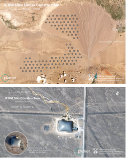
30 Jun 2021: Commercial satellite images show work underway at scores of sites across a grid covering hundreds of square miles of arid terrain in China’s Gansu province. The 119 nearly identical construction sites contain features that mirror those seen at existing launch facilities for China’s arsenal of nuclear-tipped ballistic missiles.
– The construction boom suggests a major effort to bolster the credibility of China’s nuclear deterrent, said researcher Jeffrey Lewis, an expert on China’s nuclear arsenal. Lewis, along with colleague Decker Eveleth, spotted the construction sites after weeks of scrutinizing commercial satellite photos of northwestern China. He described the scale of the project as “incredible.”
– The reported silo construction project could provide China another means of concealing its most powerful weapons. The construction sites spotted on satellite photos are arrayed in two huge swaths, covering parts of a desert basin stretching to the west and southwest of Yumen, a city of 170,000 people along China’s ancient Silk Road.
– Lewis said the silos are probably intended for a Chinese ICBM known as the DF-41. It can carry multiple warheads and reach targets as far away as 9,300 miles, potentially putting the U.S. mainland within its reach. Major excavation work on the sites began early this year, although preparations were probably underway for months, Lewis said.
– Missile silos are easily spotted by trained imagery analysts, and they are vulnerable to destruction by precision-guided missiles in the early hours of a nuclear war. For those reasons, Lewis sees the silo construction project as part of an expanded deterrent strategy by a country whose nuclear arsenal is dwarfed by those of the United States and Russia, which collectively possess more than 11,000 nuclear warheads.
– Photos of the Gansu construction project were supplied to Lewis and Eveleth by the commercial satellite company Planet, which provided a continuous stream of updated images showing progress at each of the construction sites over time. Based on his analysis, Lewis said, there was “a very good chance that China is planning a shell game” in which it hides a relatively small number of warheads across a network of silos.
Commercial earth observation satellites are increasing in numbers and capabilities. Private analysis firms will continue to expose national security developments that were previously only available to those with access to state-owned space systems. Nearly all commercial earth observation systems in operation today are owned/operated by entities operating from Coalition nations. However, Chinese and Russian companies are in the midst of developing and deploying their own constellations with significant government backing.

12 Jun 2021: China National Space Administration (CNSA) Secretary General Xu Hongliang laid out the main activities of the country’s civilian space efforts at a press conference. Lunar, interplanetary and near-Earth asteroid missions, space station construction, national satellite internet project, and developing heavy-lift launch vehicles and reusable space vehicles are major projects for 2021-2025.
south pole mission will be conducted during China’s “14th Five-Year Plan” period. Chang’e-8, to include in-situ resource utilization and 3D-printing technology tests, will follow. All missions form part of the first phase of the International Lunar Research Station (ILRS) project with Russia.
– China plans to develop a Mars sample return mission and Jupiter probe to launch in 2028 and 2030.
– A near-Earth asteroid sample return mission should launch in 2025 to small body 469219 Kamo’oalewa.
– In human spaceflight, China aims to complete its three-module space station by the end of 2022.
– Goals for satellite applications include improving civil space infrastructure and supporting ground facilities and enhancing Earth observation, communication and broadcasting, and navigation and positioning capabilities.
– Expanding international cooperation is another major strand. Examples include promoting the construction of the “Belt and Road” spatial information corridor and the BRICS remote sensing satellite constellation.
China’s government is expected to publish a dedicated space white paper later in 2021. The country’s growing military space infrastructure, including a large intelligence, surveillance and reconnaissance network and missile and electronic anti-satellite capabilities will fall outside of the scope of the report.

27 Jun 2021: Driven by national security concerns and the emergence of China as a significant threat, India is looking to expand its military capabilities in space, according to analysts. “Geopolitics is the primary driver for India to focus on the military aspects of its space program,” said Rajeswari Pillai Rajagopalan, director of the Center for Security, Strategy and Technology at the Observer Research Institute in New Delhi.
– In 2019, India established the Space Defense Agency to develop the country’s space strategy. According to domestic media reports, India is developing sensors and satellites along with ground stations to aid defense forces with space assets.
– The current key focus, analysts said, is on enhancing surveillance capabilities of sensitive areas for the military.
– It is only in recent years that India got communication and reconnaissance satellites dedicated to the armed forces, the first one went to the navy which has to guard a long coastline.
– There are demands to enhance space assets for the military, particularly as China develops more sophisticated counter space technologies such as cyber warfare.
“India has a very basic satellite program. Also, in terms of numbers, it has very few satellites compared to countries like China and the United States,” according to Manoj Joshi, a distinguished fellow at the Observer Research Foundation.
– India’s defense-related space capabilities are still nascent because of budget limitations. “India is constrained for resources. Its defense budget has been declining compared to gross domestic product in recent years,” Joshi said.
“So India is a tiny player compared to countries like China, the United States and Russia”.
India’s concerns center on its Himalayan borders with China, where disputed borders between the two have sparked military tensions; and on the Indian Ocean region, where China has increased its influence.
