issue 91 | 18 feb 2024
The integrity flash
Analysis of Developments in the Space Domain
in this issue
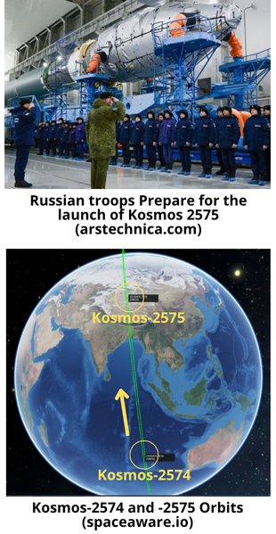
Russia Launches Kosmos-2575
9 Feb: Russia launched a Soyuz 2.1v from Plesetsk with the Kosmos-2575 satellite for the Russian Ministry of Defense. While Russia release little information regarding Kosmos-2575, the satellite’s altitude and sun-synchronous orbit suggests an imagery mission. The launch occurred 10:03 Moscow Time, the same exact time of day as the 27 Dec 2023 launch of Kosmos-2574. The two satellites are nearly co-planar. Launch Video.
– Kosmos-2575 is in a 356.2x345km orbit with an inclination of 96.8°. Its semi-major axis is ~10km greater than that of Kosmos-2574. Other parameters are nearly identical.
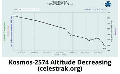
– Initially Kosmos-2574 was at a similar altitude as 2575, however Kosmos-2574 has decreased its altitude ~10km since the beginning of 2024.
– If both satellites maintain their current orbits, Kosmos-2574 will narrow the separation between the two by ~100km per orbit (thanks again Jack!)
– This is not to infer that the missions of Kosmos-2574 and -2575 are linked. It is also possible that Kosmos-2574 is no longer able to maintain its orbit and Kosmos-2575 is simply a replacement. Or Russia is adding to its inventory of imagery satellites to support its operations in Ukraine. We should be able to tell more over time and observe more satellite maneuvers.
– Kosmos-2574 is believed to be an EO MKA or Razbeg imagery satellite. It is not clear what the distinctions are between the two satellite types.
– EO MKA / Razbeg imagery satellites are believed to be a small optical reconnaissance satellites (~150kg) built by VNIIEM. Expected ground resolution is 0.9m.
– There is also speculation that Kosmos-2575 is some sort of nuclear-armed ASAT weapon. Such a satellite would be in violation of the Outer Space Treaty, of which Russia has signed.
Yaogan-41 Impact to US Pacific Strategy
6 Feb: Forbes.com article by Eric Tegler looks at the possible capabilities of the Yaogan-41 GEO based imagery satellite and their potential strategy impact. Additionally, recommend reading a 19 Jan report from Clayton Slope from the Center for Strategic & International Studies, No Place to Hide: A Look into China’s Geosynchronous Surveillance Capabilities. Excerpts below.
– Launched 15 Dec 23, Yaogan-41 can likely see, identify and track car-sized objects throughout the entire Indo-Pacific region.
– In addition to Yaogan-41, China has Gaofen-4, Gaofen-13, and Gaofen-13-02 optical satellites that also view the Indo-Pacific from geosynchronous orbit. Their surveillance capabilities are believed to include optical resolution from 50 meters down to 15 meters. Yaogan-41 is believed to have resolution down to around 2.5 meters.
– Yaogan-41’s ability to see objects in greater detail
suggests that China will be able to more easily, more persistently, identify and track U.S. and allied naval forces in the Indian and Pacific Oceans than ever before.
– Swope says the new satellite’s increased resolution may give China “the ability to identify and track even smaller objects, not just ships, but airborne assets like fighter aircraft and bombers as well.”
– Satellites at higher GEO altitudes can cover more visual territory than satellites in low earth orbit. They also offer a persistent view of a geographical area that even constellations of LEO satellites cannot match.
– Yaogan-41 could also compare data with China’s Ludi Tance-4. Launched last August, it is the world’s only synthetic-aperture radar (SAR) satellite orbiting at GEO altitude. SAR satellites can see through clouds and at night. Ludi-Tance’s reputed 20m meter resolution would be sufficient to track large ships or formations.
-Yaogan-41 used China’s largest rocket, the Long March 5, capable of lofting a 4,500 kg (9,921 lbs) payload. Yaogan-41’s payload fairing was 50 percent longer than the usual Long March 5 fairing. The previous satellites were launched with China’s Long March 3B rocket, capable of lifting 2,000 kg (4,409 lbs) into geosynchronous orbit.
– Overhead surveillance that can persistently spot, track and identify dispersed forces removes some of the complication generated by operational strategies like the Air Force’s Agile Combat Employment concept.
– In addition to its optical and SAR GEO remote sensing satellites, China operates around 300 other surveillance satellites in lower orbits.
Yaogan-41 will force the U.S. military to alter the way it does business. It may have to rely more on diversionary action and power projection from outside Yaogan-41’s field of view. It may place even more emphasis on undersea platforms or small masses of unmanned platforms to ensure freedom of maneuver, surprise, and difficult-to-target strike.
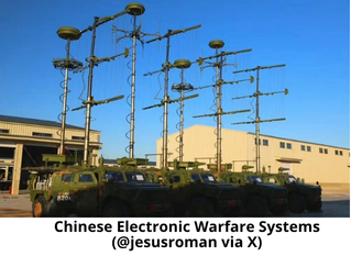
China Claims Game-Changing Electronic Warfare Device
6 Feb: Articles from SCMP reporter Stephen Chen & Eurasian Times reporter Ashish Danqwal, detail Chinese claims that their researchers have managed to monitor & analyze the complete electromagnetic spectrum in real time. With this breakthrough the report claims the Chinese military will be able to detect and lock on to enemy signals at unprecedented speeds, decode the physical parameters of these signals almost instantly, and effectively suppress them.
– According to the Chinese researchers, their new capabilities enable them to deliver the real-time analysis bandwidth into frequencies extending into the gigahertz zone, encompassing frequencies used by amateur radio enthusiasts and Starlink satellites. The previous capability was limited to monitoring spectrum usage limited to the 40-160 MHz range.
– The scientists developed a series of new signal-processing chips to achieve this enhanced capability.
– Details of the game-changing technology were published by
project lead scientist Yang Kai, a professor from the school of information and electronics at the Beijing Institute of Technology, and his team in a peer-reviewed paper in the Chinese academic journal Radio Communications Technology on January 17.
– This weapon system purportedly can emit multiple concentrated beams of electromagnetic waves from a singular antenna, facilitating simultaneous targeting of aerial, maritime, and terrestrial targets, potentially disrupting their operations.
– The report specifically references capabilities against Starlink communications. Chinese officials have frequently emphasized the need to neutralize or eliminate these satellites if they threaten national security.
– Yang said the new chips can effectively split massive amounts of collected data into smaller streams before computational processing. This reduces the processing burden and makes it possible to monitor a large number of signal sources over a wide frequency range.
– The scientists have also revamped the structure of the electromagnetic signal filter that works with the chip, and with new mathematical methods it improves the processor’s work efficiency without sacrificing any signals.
– Yang’s team also introduced artificial intelligence (AI) into the most critical data analysis process, and at least two different AI technologies are employed to work closely together to solve the various challenges encountered…The integration of in-house chips and AI has enabled the Chinese military to achieve unprecedented information perception capabilities.
– Interviews with Chinese officers and soldiers involved in recent Naval operations indicate China had activated electromagnetic emitting equipment including high-power phased array radars and firmly locked on to a series of targets including US carrier-based aircraft in the offensive and defensive contest of electronic warfare.
– On 19 Jan 2024, Chinese media claimed that Chinese scientists simulated an assault on US naval vessels. This simulation involved the launch of a barrage of missiles supported by a fleet of low-orbit electronic warfare satellites strategically positioned above an American aircraft carrier.
China v Starlink: Subject Matter Experts Weigh In
8 Feb: James Spreit, an electronic warfare subject matter expert, authored an analysis of a Chinese research paper, “The Development Status of Starlink and Its Countermeasures.” His analysis contrasts China’s assertions with the known capabilities of Starlink, focusing on the resilience of the latter to EW effects through the prism of the three core tenets of EW: Electronic Attack (EA), Electronic Protection (EP), and Electronic Support (ES). Excerpts below.
Electronic Attack vs Starlink
– Starlink’s use of a broad spectrum and Optical Intersatellite Links (OISLs) for communication between satellites makes traditional jamming tactics similar to using a blaster against a fleet of agile starfighters in space; you might cause some annoyance, but disabling them is another matter.
– Starlink satellites use dynamic beamforming capabilities that allows them to adjust their communications beams away from suspected sources of jamming, much like a spacecraft swiftly dodging incoming fire.
Electronic Protection and Starlink’s Shields
– Starlink has built-in “deflector shields” through encryption, frequency hopping, and spatial diversity of its signals.
– Starlink has the ability to operate across Ku, Ka, and optical bands and to dynamically adjust its operational parameters. Even if an adversary were to find a way to “shoot” through the shields at one frequency, the network could switch to another, rendering the attack ineffective.
Electronic Support
– Pinpointing a Starlink terminal’s location and predicting its next move requires sophisticated sensing and processing capabilities. The mobile nature of Starlink’s ground infrastructure further complicates this, as the terminals can rapidly relocate, making them elusive targets for any form of electronic targeting.
Starlink’s Resilience: A Technical Overview
– Starlink’s low Earth orbit enhances signal strength and reduces latency, similar to having a conversation with someone in the same room versus yelling across a crowded, noisy hall. This proximity makes it inherently more resistant to jamming, which relies on overpowering the signal at the receiver’s end.
– Starlink’s mesh network created by OISLs allows Starlink satellites to route communications through space, bypassing terrestrial jamming efforts.
While the claims from Chinese researchers highlight a focused effort to develop countermeasures against advanced satellite constellations like Starlink, the practical application of these measures faces significant technical challenges. Starlink’s design principles—emphasizing redundancy, agility, and protective measures—render it a formidable architecture resilient to traditional and even advanced EW tactics.
China SATCOM: A Closer Look
1 Feb: Blaine Curcio published his analysis of the Chinese satellite communications market in 2023. He notes there have been some changes in both GEO and Non-GEO Stationary Orbit (NGSO) SATCOM, with better-defined and somewhat bigger ambitions in the GEO space coming from China Satcom, and with significantly more dynamism coming in the NGSO space.
– China Satcom maintains an effective monopoly which limits their incentive to innovate. However the past couple of years has seen increased high-level support for SATCOM, spurring investment/deployment of improved capabilities.
– In Feb 2023 China launched ChinaSat-26 which is China’s first satellite of ~100 Gbps capacity. The satellite provides coverage extending from parts of Eastern Russia to the Horn of Africa and from Australia to Central Asia and is China Satcom’s largest COMSAT to date (next largest being ChinaSat-16, with 20 Gbps). With nearly 2 Gbps per beam and capabilities of bringing 450 Mbps of capacity to any single user terminal, ChinaSat-26 represents a major improvement in China Satcom’s GEO-HTS offerings.
– China Satcom also announced it plans to launch an even bigger satellite, ChinaSat-27 in 2025. ChinaSat-27 will bring 300 Gbps of capacity to most of Africa and Eurasia, with capabilities of bringing 1 Gbps to any single user terminal.
-For the next several years, it seems that there will be a lot of China Satcom capacity coming into markets where there is not immediate demand that China Satcom can serve. Markets from the Pacific Islands to Africa may find additional capacity being dumped at highly competitive prices.
-There are several new entrants into China’s attempt to develop its own pLEO constellation. China appears to be pursuing both a top-down and bottom-up perspective. Top-down there was more government support in 2023 for constellations that were not China SatNet (notably G60).
-China also published a new policy calling for the opening of the telecommunications business to private capital, and promoting the reform of the satellite internet business in steps and stages.
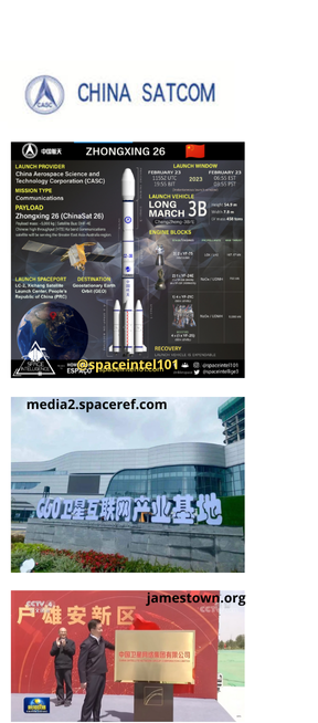
China’s SATCOM sector today is a largely domestic affair. China Satcom sells satellite capacity to Chinese state-owned broadcasters, state-owned telcos, the People’s Liberation Army (PLA), and the state at large. The offerings tend to be relatively old tech, and the solutions are confined to the Chinese market…This is going to change. By the end of 2025, China Satcom will have more GEO capacity than any other satellite operator in Asia-Pacific…and by end of 2025, we may also have the beginnings of a Chinese NGSO broadband constellation coming into the market. We should expect to see a future that is more internationally-focused, and with a greater variety of players competing.
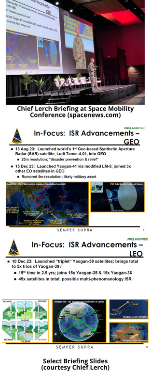
US Space Force Briefing on China’s Space Capabilities
30 Jan: Spacenews reporter Sandra Erwin highlighted a briefing from Chief Master Sgt. Ron Lerch, of the Space Systems Command’s intelligence directorate (and friend of the Flash), at the Space Mobility Conference in Orlando, FL. Chief Lerch briefed China’s rapidly advancing military space-based reconnaissance capabilities and noted Chinese remote-sensing spacecraft are providing the People’s Liberation Army unprecedented eyes in space to track U.S. and allies’ activities in Asia-Pacific and other hotspots.
– The briefing highlighted China’ launch in December of the classified Yaogan-41 optical satellite to geostationary orbit, a September launch of a trio of Yaogan-39 reconnaissance spacecraft, and the August launch of what is thought to be the world’s first geosynchronous orbit synthetic aperture radar satellite, the Ludi Tance-4. SAR satellites, unlike optical sensors, can see through clouds and at night.
– The capabilities all point towards military applications, specifically high-resolution reconnaissance across the Asia-Pacific and other strategically vital regions.
-This growing satellite fleet, coupled with China’s advancements in hypersonic weapons and anti-satellite technology, has sparked anxieties within the U.S. defense establishment. Officials have suggested that the ability to track and monitor American movements in the region, from troop deployments to ship movements, could significantly tip the scales in China’s favor during potential conflicts.
– Lerch said it’s important for the U.S. military to understand China’s space ambitions and how the PLA could employ satellites in a military conflict. “And that’s why these things are issues that we consider to be very urgent,” he added. “There doesn’t seem to be anything to suggest that Xi Jinping and the CCP [Chinese Communist Party] are slowing down.”
– U.S. Army leaders in a recent policy guidance document said commanders should take proactive measures aimed at complicating Chinese overhead imaging attempts.
(Space) Ships Passing in the Night
Dec 2023: Robin Dickey from the Aerospace Corporation’s Center for Space Policy and Strategy released her paper looking into the potential use of the Convention on the International Regulations for Preventing Collisions at Sea (COLREGs) to help create basic rules of the road for space. She notes the COLREGs contain several rules and principles that could be adapted to help identify collision risks in a conditions-based approach, make decisions on which satellites should maneuver to avoid collision, and facilitate communication between operators to resolve confusion or disagreements. Below is an excerpt from her most excellent 18-page paper (which you should read).
– In other domains, rules of the road help operators make decisions and take action to avoid collision, but these rules do not exist yet for space.
– Policymakers…may need to consider the approach of drawing lessons from other domains. Such analogies can take concepts from norms or rules that already work in one environment and translate them to the physical and legal context of space.
– COLREGs is a uniquely useful document to analogize to space because, unlike broader treaties such as the UN Convention of the Law of the Sea, COLREGs focuses exclusively on guidance for avoiding collisions.
-COLREGs exists in a legal environment that is more comparable
to space than the air domain…both sea and space include vast swaths of the domain where no national actor has sovereignty or responsibility and collision-avoidance decisions are up to the individual operators.
– COLREGs provides guidance for how to operate in a low visibility environment, highlights multiple paths for communication, and gives directions on how to respond if other safeguards fail, all of which could make similar situations in space less dangerous.
– COLREGs do not attempt to define a “safe distance” or a “safe speed.” Those terms are mentioned but are not assigned a specific number. Instead, the convention establishes a series of criteria to help the operators of vessels decide which situations are at high risk of collision or not…Many of these conditions are directly translatable to relevant concerns in space. Just like mariners, space operators must contend with problems related to “visibility,” maneuverability, and environmental hazards.
-The COLREGs conditions-based approach…complements the metric used to determine collision risk in space today. Operators currently look for a probability of collision based on where and when the paths of two space objects are expected to intersect and the margin of error for their predictions.
– COLREGs provides a multifaceted approach to determining right of way.
– The Space Safety Coalition updated its “Best Practices for the Sustainability of Space Operations,” including a matrix of which spacecraft should move to avoid a potential collision. There are five categories: (1) non-maneuverable, (2) minimally maneuverable, (3) maneuverable, (4) automated collision avoidance, and (5) crewed.
– Parts of the space community are already drawing from right-of-way models similar to what is established in COLREGs
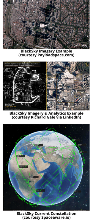
BlackSky to Supply Indonesia with Imagery Satellites
8 Feb: BlackSky, a US Earth observation and data analytics company, will provide imagery satellites and services to the Indonesian ministry of defense. The contract extends over multiple years and is reportedly worth $50M (US). BlackSky will partner with Thales Alenia Space (a joint French/Italian venture) to develop an Earth observation constellation tailored for Indonesia’s security requirements.
– Indonesia will gain access to BlackSky’s high-revisit imagery and analytics and will own two of BlackSky’s next-generation Earth observation satellites. The satellites represent the beginning of a future constellation that could include a mix of imaging satellites provided by BlackSky and others built by Thales Alenia.
– Indonesia’s PT Len Industri, a state-owned defense company, will lead the efforts of both Thales Alenia Space and BlackSky.
-In January 2024 Indonesia awarded BlackSky a separate contract to deliver real-time imagery and analytic support to Indonesia’s MoD.
– Thales Alenia and BlackSky are co-owners of LeoStella, a satellite manufacturer based in Seattle that produces spacecraft for BlackSky and other customers.
– BlackSky currently operates a constellation of 16 electro-optical satellites. All have been launched on commercial rockets, with the majority being deployed using the Rocketlab Electron SLV.
-As part of this new contract BlackSky expects to deliver two third-generation electro-optical imaging satellites to the Indonesian MoD in about two years.
– Thales Alenia Space will develop the synthetic aperture radar satellites.
-BlackSky will also provide ground station capabilities and flight operations support to the MoD.
– BlackSky’s current constellation is made up of Gen-2 satellites that provide 1-meter resolution imagery. The Gen-3 class satellites are capable of 35 cm electro-optical imagery and will have advanced communications capabilities that help reduce tasking-to-delivery speeds. The Gen-3 satellites also have dual optical-infrared sensors that allow for imaging at night and in low-light conditions.
This contract is a great example of how a smaller nation can quickly build/deploy exquisite space-based ISR capabilities using commercial partners…and do so at a fraction of the time and financial investments of traditional nation-state programs.