issue 92 | 10 march 2024
The integrity flash
Analysis of Developments in the Space Domain
in this issue
China Launches TJS-11 Experimental Satellite
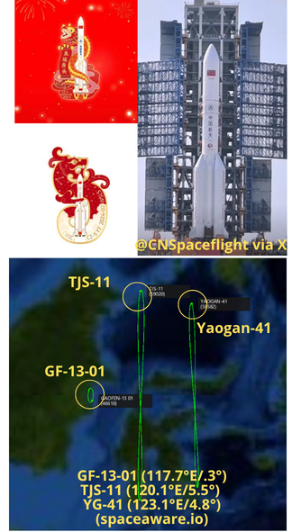
23 Feb: China launched a Long March-5 containing the TJS-11 experimental satellite from Wenchang. China released little information regarding the satellite’s mission, stating it would be mainly used to carry out multi-band, high-speed satellite communication technology verification. Like other recently launched TJS satellites, TJS-11 is in GEO. The satellite remained in GTO until ~ 4 March. It is now located at 120.1°E. As with Yaogan-41, the TJS-11 launch featured an extended fairing on the LM-5. TJS-11’s GEO orbit also appears to be similarly inclined as Yaogan-41 (5.5° vs 4.8° respectively). Yaogan-41 is believed to be an imagery satellite. Launch Video.
– TJS-11 was in a Geosynchronous Transfer Orbit (GTO) from 23 Feb – ~4 Mar or nearly 10 days. It has now joined the GEO belt at 120.1°E (as of 5 March).
-TJS-11 is the first TJS satellite launched on a LM-5. As with the YG-41 imagery satellite launched 15 Dec 2023 the LM-5 was equipped with an elongated 18.5m fairing (normal is 12.3m).
-TJS-11 is positioned between Gaofen-13-01(2.4° separation) and YG-41 (3° separation). Gaofen-13-01 is also a GEO-based imagery satellite.
– At 5.5° TJS-11’s orbit is the most inclined of any of the TJS satellite family. The TJS constellation is believed to consist of primarily SIGINT (TJS-1/4/9) and Missile Warning (TJS-2/5/6) satellites. TJS-3, 7 and 10 have an unknown missions. TJS-11’s unique orbit suggests the satellite may be fulfilling a different mission.
– TJS-11’s inclination is .7° greater than that of Yaogan-41.
– China currently has 4 GEO based EO/IR imagery satellites: GF-4, GF-13-01, GF-13-02 and YG-41.
– China is also the only nation in the world to have a Synthetic Aperture Radar (SAR) imaging satellite operating in GEO. LudiTance-4-01 was launched in August 2023. It is located further west (89.6°E) and has an inclination of >16°. China launched LudiTance-4-01 on 12 Aug 2023 from Xichang using a LM-3B.

China Launches Internet - High Orbit Satellite 01
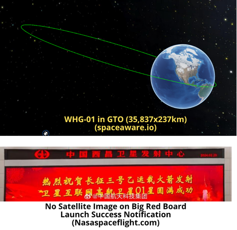
29 Feb: China launched a Long March-3B from Xichang carrying the Weixing Hulianwan Gaogui-01 (WHG-01), which translates to high-orbit internet services satellite. As of 8 March the satellite remained in GTO. There is conjecture that China intends to use the satellite to provide connectivity in the extreme Northern and Southern latitudes, similar to Inmarsat Global. There is also the potential that “high” in this case refers to throughput…in that case the satellite may be more comparable to Viasat-3 or Jupiter-3. Chinese media and state announcements provided no additional information regarding WHG-01’s mission. Launch Video.
– Per Andrew Jones: State media Xinhua reported in November that a first high orbit internet satellite had been completed and would be used to provide coverage for the entirety of China and key areas along the “Belt and Road” initiative.
– As of 8 March available space catalogs continued to show WHG-01 in GTO. Orbital characteristics will help estimate the satellite’s mission 🤞. Look for further updates in future editions of the Flash.

CASI Report: China’s View of Coercive Space Activities
24 Feb: Kevin Pollpeter of the China Aerospace Studies Institute (CASI) released his latest report on China’s space policies and operations. Mr Pollpeter concludes that “People’s Liberation Army (PLA) researchers have assessed space capabilities as playing an outsized role in strategic coercive efforts.” Furthermore, “PRC researchers state that coercive activities can occur in both peacetime and wartime and can involve demonstrations of space power, tests of space capabilities, and the use of force.” Excerpts below.
– The People’s Republic of China (PRC) is developing space technologies, in part, to deter and
compel the United States from taking actions that Beijing deems counter to its national security interests.
-(PLA) researchers have assessed space capabilities as playing an outsized role in strategic coercive efforts…and perceive space capabilities as a more usable and effective method of influencing an adversary than nuclear weapons.
– PRC researchers state that coercive activities can occur in both peacetime and wartime…and argue that increased space power allows militaries to strengthen their coercive space capabilities for use against potential adversaries.
-PLA researchers discuss eight types of coercive activities that provide an escalatory ladder
from least to most escalatory: 1) Enhancing conventional force capabilities; 2) Deterrence by denial; 3) Deterrence by detection; 4) Deterrence by punishment; 5) Displays of space power; 6) Space warfare exercises; 7) Space power deployments; and 8) Coercive space strikes.
– Space and counterspace capabilities can not only deter adversaries from attacking PRC satellites but can also form one element of an overall coercive campaign intended to influence an adversary from taking military action in other domains.
– PLA writings state that space coercion may be the first type of coercive measure used in a conflict…and describe coercive measures as being conducted first in space
–PRC development of a wide range of counterspace capabilities, including cyber, direct-ascent, co-orbital, directed-energy, and electronic warfare technologies, suggests that it is taking a combined arms approach to space warfare to threaten U.S. satellites from the ground to geosynchronous orbit…<such an approach would> allow the PRC to tailor its responses to particular situations.
– China’s Space-based C4ISR capabilities can enable the PLA to detect U.S. military deployments before a conflict begins <and> improve the PLA’s ability to achieve a more transparent operational environment and facilitate the use of capabilities to degrade U.S. forces. While Counterspace capabilities could be used to threaten U.S. space-based C4ISR capabilities that have allowed it to overmatch conventional adversaries.
-Space coercion can be used to threaten critical economic functions that space enables…and could degrade the US economy.
– Between 2018 and 2022, the PRC nearly doubled its number of intelligence, surveillance, and reconnaissance (ISR) satellites to more than 250, “most of which could support monitoring, tracking, and targeting of U.S. and allied forces worldwide, especially throughout the Indo-Pacific region.
The PLA is developing space technologies, in part, to prevent or mitigate foreign interference in its stated national security interests…<and is> shifting from a force focused on nuclear deterrence to one more capable of achieving a variety of coercive effects in, from, and to space.
Pardon our Progress: China’s pLEO Development Efforts
7 Mar 2024: Developing a proliferated Low Earth Orbit constellation similar to Starlink appears to be a high priority for the Chinese government. Here’s a China Space Monitor article from November 2023. In his article Blaine notes that in 2023 more entrants joined the race, combining with the state-backed Guowong/ChinaSatNet effort. As we’ve seen, when China invests in developing a capability it usually achieves its objectives. Here is a look at the on-orbit test satellites I’m tracking (16 of them). I suspect we will see quite a few more in 2024.
Galaxy Space Yinhe Constellation: On 5 March 2022 Galaxy Space launched 6 of its Yinhe-2 satellites on a LM-2C from Xichang. Two years later the satellites are all listed as “Active.” Five of the six satellites are operating on the same orbital plane, ~565x455kms and inclined 63.5°. The sixth satellite has decreased its altitude ~130kms and does not appear to have maneuvered since arriving on orbit. Galaxy Space’s first Yinhe launch was in 2020 when it sent a Yinhe-1 satellite into orbit on top of a KZ-1A. The Yinhe-1 is still active and is in a 647x625km orbit with a 86.4° inclination.
Hulianwang Jishu Shiyan (WHJSW): The WHJSW satellites are reportedly test satellites for Guowang (SatNet), the Chinese state-owned LEO internet constellation. China conducted 3 launches in 2023 and placed 6 WHJSW satellites on orbit. Two of the launches used the LM-2C from Jiuquan while the third used the Jielong-3 which launched from the Yellow Sea. The first launch (LM-2C) carried two satellites, the second (Jielong-3) 1 satellite and the remaining three satellites were on the final launch (LM-2C).
Each of the three launches placed their payloads into different orbits. The first two are in a 1,121×1,096km orbit with 86.5° inclination. The single satellite from the second launch is 923x907km and also inclined 86.5°. The final three satellites are at 945x935km and inclined 50°.
There are potentially another 3 WHJSW satellites on orbit, launched from a LM-2D from Xichang on 23 Nov 2023. While the naming convention doesn’t match exactly and 2 of the objects are currently cataloged as unknown. The objects are orbiting at 1,114×1,095km and inclined 50.0°.
– Longjiang: On 8 Jun, China launched a KZ-1A with the Longjiang-3 experimental stackable communications satellite, jointly developed by a commercial satellite company and its parent entity, the Harbin Institute of Technology (HIT). Longjiang-3 is in a 466x458km orbit and inclined 49.1°.

Russia Launches Meteor-M 2-4 Satellite + 18 Others
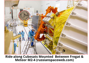
29 Feb: Russia launched a Soyuz-2.1b from Vostochny containing the Meteor-M No. 2-4 hydrometeorological satellite and 18 small satellites. Meteor-M No. 2-4 (~3250 kg) is the sixth spacecraft in the Russian Meteor-M series of remote sensing satellites, intended to gather hydrometeorological data. Launch Video.
– Meteor in a 812 x 823 km x 98.6 deg orbit. Two objects are in 730 x 750 km; four in 503 x 750 km; 14 in 485 x 509 km orbit, reflecting multiple orbit changes by the Fregat stage prior to its deorbit.
– Anatoly Zak: Meteor was built at Moscow-based VNIIEM Corporation, which relied on its standard Resurs-UKP-M platform as a service module for the mission. It’s expected to operate for at least 5 years. Meteor-M satellites are designed to watch global weather and the ozone layer, to measure the ocean surface temperature and ice conditions, which can facilitate shipping in the polar regions of our planet. It may also have a military mission.
– Jonathan McDowell: the other satellites were the Zorkiy-2M No. 2, Marafon-D GVM, sixteen SITRO-AIS cubesats for Sputnix, and Iran’s small Pars-1 imaging satellite.
– The ASTRO-AIS satellites were designed for marine tracking, surveillance, and monitoring. the AIS system enables the tracking and monitoring of military vessels and coast guards.
– The Iranian payload is Pars-1 is described as a small imaging satellite from the Iranian Space Research Institute.
– The Pars-1 satellite has a mass of 134 kg and is equipped with three imaging cameras. The design, construction, assembly, and testing phases of the research satellite Pars-1 were completed at the Iranian Space Research Institute.

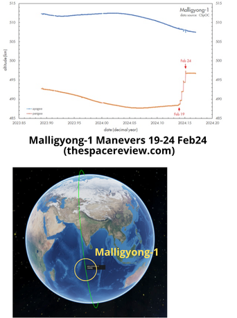
4 Mar: Article from the Marco Langbroek examing the orbital maneuvers North Korea’s first military reconnaissance satellite, the Malligyong 1. After the 21 Nov 2023 launch, initial western responses were skeptical, stating that the satellite, although it successfully reached orbit, was nevertheless non-functional. However, starting on 19 Feb, Malligyong-1 began showing unambiguous signs of life. From 19-24 Feb 2024, the satellite performed five consecutive small orbit raising maneuvers, one each day. Excerpts Below.
– The series of small maneuvers raised the perigee altitude (the lowest point in its elliptical orbit) by nine kilometers, from 488 to 497 kilometers…in doing so it also circularized its orbit.
– The maneuvers also reduced the daily precession of the ascending node (which had been slightly growing over time) to a value closer to the ideal value of 0.986 degrees/day, in order to preserve the Sun-synchronous character of the orbit.
– Malligyong-1 maneuvering shows that the satellite is not “dead,” but functional—with the caveat that we do not know whether the onboard camera is actually taking images. Second, it underlines that the North Koreans have clear control over the satellite, including its attitude, and can modify its orbit. North Korea can now actively prolong the orbital lifetime of their satellites by doing periodic orbit raises.
This is the first time that a North Korean satellite has shown the ability to do orbital maneuvers.