issue 97 | 19 may 2024
The integrity flash
Analysis of Developments in the Space Domain
in this issue
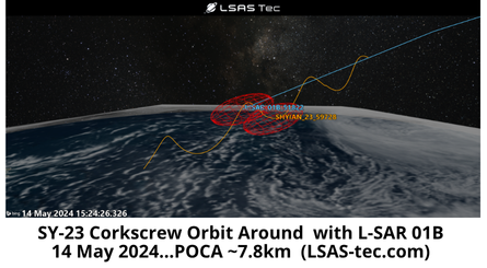
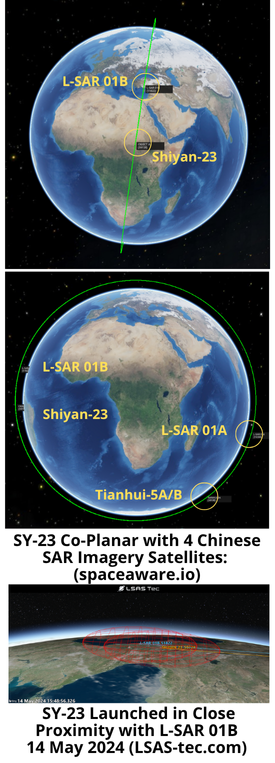
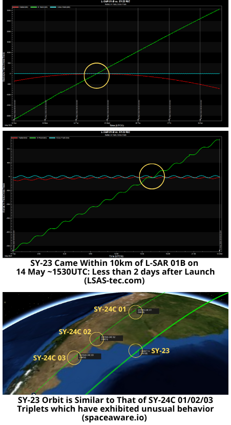
12 May: China launched a Long March-4C from Jiuquan with the Shiyan-23 (SY-23) experimentation satellite. As is typical for the Shiyan satellites, China release very little mission information, saying only that the satellite successfully entered the planned orbit and “will mainly be used for space environment monitoring,” which could indicate a space-centric mission rather than Earth remote sensing. SY-23 is in a sun-synchronous orbit and appears to be co-planar with 4 Chinese SAR satellites launched between 2022 and 2024. Being co-planar with other SAR imagery satellites may allow China to conduct SAR or counter-SAR related tests while removing orbital variables. Launch Video.
– The LM-4C is a 3-stage space launch vehicle capable of delivering 2,800kg objects to Sun Synchronous orbit. China used the LM-4C to launch Shiyan-20A/B satellites into a 800km/60° orbit on 19 Dec 2022.
– SY-23 is currently in a 598.6 x 589.8km orbit with 97.8° inclination. This orbit is nearly co-planar with 4 recently launched Chinese SAR satellites.
-Specifically, SY-23 is co-planar with L-SAR 01A (51284), L-SAR 01B (51822), and Tianhui-5A/B (58199, 58201).
– China launched SY-23 to a slightly lower SMA than L-SAR 01B (597.3km vs 602.9km). Over its first few days on orbit, SY-23 slowly passed L-SAR 01B resulting of a point of closest approach of ~7.8km.
– SY-23 is also lower than L-SAR 01A (597.3km vs 602.9) and Tianhui-5A & 5B (597.3 vs 605.5) and over the next few weeks will pass these satellites as well.
– L-SAR 01A/B is a distributed SAR satellite system composed of two L-band SAR satellites with the same design parameters. In orbit, it has two formation flight modes of “follow-up flight” and “around flight”.
-The Tianhue constellation is made up of 12 satellites launched between 2010 and 2023.
– The constellation has both optical and SAR imaging satellites and is used to support cartography.
– Tianhui-4A/B, 5A/B & 6A/B satellites (Tianhui-3 does not exist yet) — operate in formations of two, and are also likely SAR capable.
– SY-23 is also in a similar orbit (but not co-planar) with the mysterious Shiyan-24 A/B/C triplets. SY-24 exhibited suspicious behavior earlier in 2024 which we detailed in past Flash editions.
– SY-23 has an SMA 13km greater than the SY-24A/B/C triplets and its inclination and RAAN are also .5° and 6° greater than (respectively) than SY-24A/B/C.
– There may not be any relationship between the SY-23 and SY-24C missions and the orbital similarities may well be purely coincidental. With their current orbital parameters the SY-24 triplets will pass SY-23 every ~22 days, the first pass occurred on 17 May 2024.
-The Chinese official statement of SY-23’s mission was the satellite “will mainly be used for space environment monitoring.”
– This statement differs from other Chinese descriptions of classified missions.
- After the launch of YG-40A/B/C (believed to be a signals collection mission due to the satellite formation), China stated the satellites would be used for “electromagnetic environment probing.”
- China said the SY-24 01 A/B/C satellites “will be mainly used for space science and technology experiments”.
- China stated the Yaogan-35 satellites, would be for “scientific experiments, land and resource census, and other fields.”
China’s SY-23 statement hints at a space-centric mission as opposed to an Earth observation mission. Being in SSO/polar orbit will present frequent conjunction opportunities.
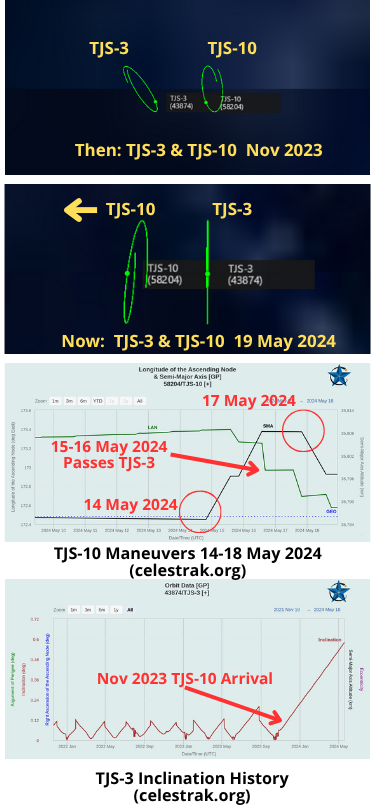
19 May 2024: China maneuvered TJS-10 on 14 May and then again on 17 May increasing its altitude and initiating a westward drift. TJS-10 had been located just to the East of TJS-3 for the past 6 months. Between 16-17 May TJS-10 passed TJS-3, then slowed its drift. TJS-10 continues to drift away from TJS-3 and, at its current altitude, is moving west at .136° per day. The TJS family of spacecraft are classified Chinese military satellites associated with Signals Intelligence (SIGINT), missile warning, and “satellite inspection” missions. When TJS-10 launched on 3 Nov 2023 Chinese state media only noted the spacecraft was a “communications technology experiment.”
– Launched on 3 Nov 2023, TJS-10 circularized its orbit into GEO on 9 Nov. From 9 Nov 2023 – 14 May 2024 the satellite was located at 173.3-173.4°E longitude.
– TJS-3, has maintained its position 173.1°E since late-May 2023. It appears TJS-3 made several maneuvers in early Oct 2023. and increased its inclination from 0° to 0.1°…identical to TJS-10.
-It appears that after TJS-10 and TJS-3 began operating near one another both increased their inclination (probably naturally) from .1° to their current values of .6°.
– This increased inclination is a deviation for TJS-3 as China had maintained its inclination between 0.0 – 0.2° from Nov 2021 – Dec 2023.
-On 14 May TJS-10 increased its SMA 23.1km. From 14-16 May TJS-10 drifted from 173.3°E to 172.7°E, likely crossing paths with TJS-3 on the way.
-On 17 May TJS-10 again maneuvered, this time decreasing its SMA -11.1km, slowing its westward drift to ~.136°/day.
– China launched TJS-3 in 2018, and immediately engaged in unusual behavior for geostationary satellites. It performed several RPO events with its Apogee Kick Motor (see video.) Some sources have identified TJS-3 as a a GEO belt “inspector satellite.”
-TJS-10 and TJS-3 operated near one another for 6 months, nearly to the day. China may have conducted testing using both satellites during this time frame.
-TJS-10’s mission remains unclear.
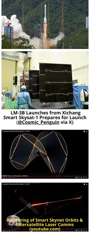
9 May: China launched a Long March-3B from Xichang containing 2 satellites destined for Medium Earth Orbit (MEO). Smart SkyNet-1 01 (A/B) satellites are “China’s first medium-orbit broadband communication satellites” and part of the “Smart Skynet” network of 8 satellites deployed into 20,000km altitude orbits. China can expand the constellation to 16 or 32 satellites. Creating a global constellation in MEO will compliment China’s plans for a 13,000 satellite constellation in LEO as well as its existing GEO satellites. Neither satellite has been reported in the spacetrack.org catalog (as of 19 May).
Launch Video.
– Excerpts from Andrew Jones article:
- The satellites were developed by CASC’s Shanghai Academy of Spaceflight Technology (SAST) for Shanghai Tsingshen Technology Development Co. Ltd. Tsingshen Tech was founded in 2018. It is collaborating with Tsinghua University and the Shanghai government to create a medium Earth orbit (MEO) broadband satellite constellation.
- Smart Skynet-1 (01) satellite A is equipped with a multi-beam, high-speed microwave link, an inter-satellite two-way laser link and an onboard digital processing and forwarding platform, according to SAST. Satellite B is equipped with an inter-satellite laser link experiment payload. On-orbit activities will include technology validation of flexible inter-satellite links and satellite-to-ground transmission.
- SAST states that Smart SkyNet could be joined up with China’s low Earth orbit communications megaconstellations, as well as comms satellites in geostationary orbit. This would provide access to all types of users in all scenarios and all domains.
<Editor’s Note: having multi-orbital regime connectivity is extremely resilient and useful for maritime operations in a contested environment>
– Per a June 2021 press release, Smart Skynet will be composed 8 satellites deployed in a 20,000km orbit. The constellation will utilize communication links between satellites and provide continuous global coverage, including at the North and South Poles.
– The press released mentioned the initial launch of 2 test satellites and the intent to complete “the deployment of the first set of eight satellites by 2025.”
– With 8 satellites on orbit the total communication bandwidth capacity will 200+Gbps, capable of supporting 500,000+ users.
– The second and third satellites sets will increase capacity to the Tbps level.
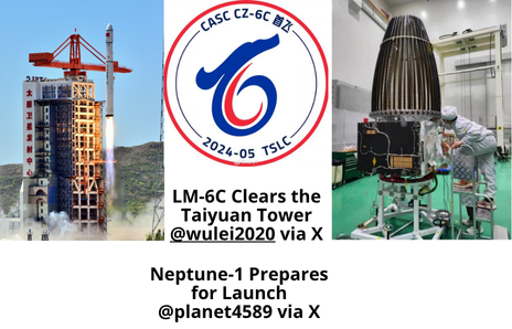
7 May 2024: China successfully completed the maiden launch its new Long March-6C space launch vehicle from Taiyuan Satellite Launch Center. The LM-6C carried 4 commercial remote sensing satellites, the primary being a 239kg SAR imaging satellite, HaiWangSAT-01 (Neptune-01). The LM-6C a two-stage liquid-fueled (liquid oxygen/kerosene) rocket developed by the China Aerospace Science and Technology Corporation (CASC) and is capable of placing a 2.4 ton payload into 500km sun synchronous orbit. Launch Video. Bonus Video showing differences with LM-6A and containing a techno beat!
– In addition to the Neptune-1, the LM-6C also carried the SmartSat-1C (another SAR imager), Kuanfu Guangxue (wide-band optical satellite), and GaoFen Shipin (High Resolution Video Satellite).
-As of 13 May all 4 satellites were in SSO with ~507km apogees and ~488km perigees. All are inclined at 97.4°.
-The LM-6C is slightly shorter than the LM-6A and does not have the 4 solid-rocket boosters. By comparison the LM-6A can lift a ~4,500kg payload to 700km SSO. Other than the solid-rocket boosters the 2 variants use the same propulsion systems (YF-100 first stage and YF-115 second stage).
– There are now 17 Long March variants in operation and there may be an 18th in the near future. The initial launch of the Long March 12 is rumored to be scheduled for July 2024. The LM-12 is believed to be able to carry 6 tons of cargo to 700km SSO.
-China has stated it intends to conduct at least 100 launches in 2024. For those keeping score at home, China has conducted 22 launches since 1 Jan 2024.

16 May 2024: New information from US government officials indicates that Cosmos-2553, launched in Feb 2022 just prior to Russia’s invasion of Ukraine, is designed to test components for a nuclear space-based weapon. U.S. officials told The Wall Street Journal that Cosmos-2553 is not itself armed with a nuke, but it is part of Moscow’s ongoing anti-satellite program. If Russia were ever to develop and operationalize such a weapon, it would be capable of rendering hundreds of satellites inoperable. This would be an ideal weapon for large constellations such as Starlink, which Russia has been trying to degrade for the past 2 years. However, Bart Hendryckx of The Space Review, notes that Cosmos-2553’s primary mission is very likely a SAR imager which may be conducting radiation testing as a secondary function. Watch Video.
– Russia launched Cosmos-2553 from Plesetsk on 5 Feb 2022, less than 3 weeks prior to its invasion of Ukraine.
-At the time Russia stated Cosmos-2553 was “a technological satellite equipped with newly developed on-board instruments and systems in order to test them in conditions of radiation and heavy charged particles.”
-At the time there was speculation that Cosmos-2553 was likely a new type of military intelligence satellite called Neitron. Neitron was believed to be a SAR imaging satellite based on the Kondor platform, but customized for operation in a considerably higher orbit.
-Cosmos-2553 is in an unusually high altitude for a SAR or optical imagery satellite. It is in a near circular orbit with a SMA of 1,996.1km and a 67.1° inclination.
-Russia operates no other satellites at this altitude. Other than debris and rocket bodies, the closest active Russian satellite listed in the Spacetrack.org catalog is a Radio Rosto satellite launched in 1994.
-On 13 May 2024 Bart Hendryckx released part 1 of an article, “Russian research on space nukes and alternative counterspace weapons.” In his article Mr Hendryckx notes “there are compelling reasons to believe that it (Cosmos-2553) is a military radar reconnaissance satellite.” More excerpts below:
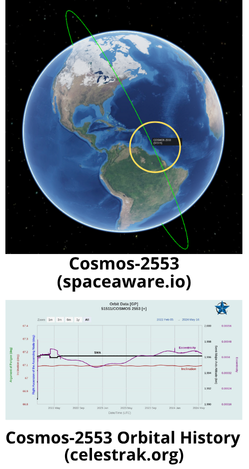
- Kosmos-2553 repeats its ground track with an accuracy of about one kilometer every four days, which is strongly indicative of an Earth remote sensing mission. It would be ideal for interferometric synthetic aperture radar (InSAR) imaging, a technique that requires a satellite to pass over exactly the same region at different times and obtain images from slightly different viewing angles to generate 3D maps of features on Earth.
- There are no obvious signs from publicly available source material that the mission of Kosmos-2553 has any direct connection with the suspected nuclear weapon. Based on the available information, all that it could potentially be testing with relation to such a weapon would be shielding to protect satellites from the effects of its detonation. It could also demonstrate the ability to operate satellites in what is sometimes called a ”nuclear-safe orbit,” one that is high and stable enough for a nuclear device (whether that be a bomb or a reactor) to be stored safely for an unlimited period of time.
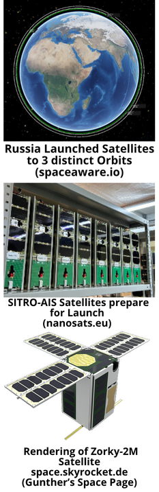
16 May: Russia launched a Soyuz 2.1b from Plesetsk Cosmodrome carrying ~9-11 satellites to three different orbits (all are in LEO). There is ongoing discussion as to the exact number/nature of the payloads. Currently the Spacetrack.org catalog shows 9 objects: only 1 object (presumed to be Cosmos-2576) is listed as “Active” and is in a 448x432km orbit, 5 objects are in ~548x533km orbits, and then 3 objects in 793x777km orbits. Status of all but the first object are listed as “unknown.” Moscow-based Sputniks company announced the successful launch of four SITRO-AIS (used for tracking ships through their automated identification system <AIS>) and two Zorky-2M imagery satellites. Russia has previously launched SITRO-AIS and Zorky-2M satellites together and into orbits consistent with the 5 objects in ~548x533km orbits. Launch Video.
-Per Orbital Focus:
- Cosmos 2576 is the object orbiting at 448x432km.
- The satellite is “possibly equipped with sensors that allow it to observe or monitor other satellites in orbit. It also may carry an Earth imaging system. Released from Fregat soon after launch. Orbit is in a similar plane to USA 314 (48247, 2021-032A) – a military/government imaging satellite owned by the US.”
- The 3 objects in the higher (793x777km) orbit are also classified as military satellites with an unknown mission. <Editor’s note: the only active Russian satellites I could find even close to this operating altitude are the Meteor-M2 satellites, but these have an SMA 24km greater than these 3 objects>
- Orbital Focus lists 4x SITRO-AIS and 2x Zorky-2M satellites in the 548x533km orbit. The site assumes 2 additional objects will be identified, one for the Fregat upper stage, the second as either a SITRO-AIS or Zorky-2M.
– Per Marco Longbroek: “The orbital altitude is some 53.5 km lower than the typical orbit of a BARS M satellite, indeed suggesting this might be something new…Cosmos-2576 is clearly lower than that of USA 314, but RAAN and inclination are indeed very close (0.02 and 0.8 deg resp)…In the current orbit it makes approaches to USA 314 at ~340 km distance each 1.4 days.”
– From Bart Hendryckx: “So at this point it looks like we have the six civilian cubesats announced by Sputnix and three military satellites. The Fregat seems to have performed four burns to place the satellites into their different orbits before de-orbiting itself. My guess is that the cubesats are the ones in the 435 to 550 km orbits. The earlier Zorkiy-2M and SITRO-AIS satellites orbit at similar altitudes. The three military satellites would then be in the 780×796 km orbit. Could very well be the trio of Razbeg/14F169 satellites as speculated here earlier, but we’ll have to look at the further behavior of these satellite.”
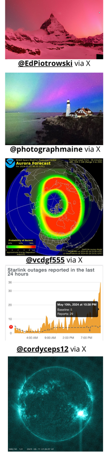
15 May: Judging from the amazing images from as far south as Florida, there were quite a few people who noticed the recent geomagnetic storm that occurred 11-12 May 2024. The very southerly appearance of the Northern Lights (aurora borealis) was a result of a massive cluster of sunspots ~17x the width of the Earth releasing at least seven powerful Coronal Mass Ejections (CMEs) in Earth’s direction. Below are excerpts from a recent article released in the Payload Space daily newsletter (recommend subscribing…they have some great stuff, to include their Pathfinder podcast!)
– The Sun is at the peak of an ~11-year cycle that began in 2019. That means we’re seeing more solar activity than usual. More frequent solar flares and coronal mass ejections (CMEs) = more concentrated radiation flowing from the Sun to Earth = more disruption of the Earth’s magnetic field.
– The Earth’s magnetic field can generally deflect the bulk of the solar wind, but this <the weekend CMEs> powerful series of bursts got through to interact with the upper atmosphere.
– Oxygen, nitrogen, and other elements in that upper atmosphere were ionized by the radiation, leading to glowing, southern-reaching auroras.
– This solar activity also tends to make the atmosphere puff up, increasing drag on satellites—particularly ones in LEO.
– Though the storm hasn’t brought down any satellites or fried any essential systems that we know of, there were minor disruptions to some services, and many operators chose to pause normal operations. NOAA told NPR that there were disruptions to GPS, but nothing life-threatening for the mission.
-That puffing of the atmosphere meant that satellites had to work harder than usual to maintain their altitude and keep themselves pointing in the right direction. ESA shared a graph of the power usage of the orbit control system on its Sentinel 2 satellite, which spiked during the storm:
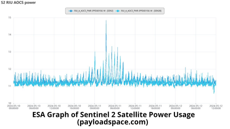

– Starlink, as a whole, also muddled through the storm intact, per an Elon tweet. In 2022, increased drag caused by a CME forced 38 Starlink satellites to deorbit within days after they were launched, before they had reached their operational altitude. There’s been no such incident this time around, though the birds were “under a lot of pressure.”
While not mentioned in the Payload Article the solar activity of 11-12 May was nothing compared to what occurred in September 1859 in what has become known as the “Carrington Event.” (See Video).
From the New York Times on 10 May 2024:
– It is the strongest such storm to reach Earth since Halloween of 2003. That one was strong enough to create power outages in Sweden and damage transformers in South Africa.
– The solar activity is so powerful that the National Oceanic and Atmospheric Administration, which monitors space weather, issued an unusual storm watch for the first time in 19 years, which was then upgraded to a warning.
– A geomagnetic storm watch or warning indicates that space weather may affect critical infrastructure on or orbiting near Earth. It may introduce additional current into systems, which could damage pipelines, railroad tracks and power lines.
– The most notable solar storm recorded in history occurred in 1859. Known as the Carrington Event, it lasted for nearly a week, creating aurora that stretched down to Hawaii and Central America and impacting hundreds of thousands of miles of telegraph lines.
– NOAA classifies these storms on a “G” scale of 1 to 5, with G1 being minor and G5 being extreme. The most extreme storms can cause widespread blackouts and damage to infrastructure on Earth. Satellites may also have trouble orienting themselves or sending or receiving information during these events.
– The current storm is classified as G5, or “extreme.” It is caused by a cluster of sunspots — dark, cool regions on the solar surface — that is about 16 times the diameter of Earth. The cluster is flaring and ejecting material every six to 12 hours.
– More flares and expulsions from this cluster are expected, but because of the sun’s rotation the cluster will be oriented in a position less likely to affect Earth. In the coming weeks, the sunspots may appear again on the left side of the sun, but it is difficult for scientists to predict whether this will cause another bout of activity.
Pics o’ the Fortnight!