issue 130 | 28 sep 2025
The integrity flash
Analysis of Developments in the Space Domain
in this issue
Job Board
hiring
hiring
hiring
China Adds 4 Satellites to Guowang Test Network
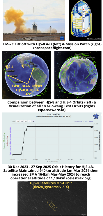
16 Sep 2025: China launched a Long March-2C with a Yuanzheng-1S upper stage carrying 4 test satellites for the Guowang constellation (65617-65620) from Jiuquan. Jonathan McDowell has labeled the satellites Hulianwang Jishu Shiyan-8 A-D (HJS-8) which is what I’m going with. According to official sources, all 4 HJS-8 satellites successfully reached the preset orbits. In an official announcement Chinese officials disclosed that the “StarNet (Guowang) system has successfully launched a total of ️102 satellites, including 18 test ️ (all in low orbit), 3 high-orbit ️, and 81 low-orbit.” These numbers match what I have in my catalog (hallelujah) and also confirm the 3 GEO satellites China launched in 2024 (59069, 60327 & 61503) are somehow associated with the Guowang effort. Launch Video.
– The 4 HJS-8 satellites are in low earth orbit, at 809 x 812km with an inclination of 50.0°.
– The launch appears similar to the 30 Dec 2023 launch of 3 Guowang test satellites (Hulianwang Jishu Shiyan (HJS-4A/B/C) (58691, 58692, 58693).
- The HJS-4 launch was also a LM-2C from Jiuquan but only carried 3 satellites to their 50.0° inclined orbit.
- Likely due to the reduced mass of having only 3 satellites, the LM-2C delivered all 3 HJS-4 satellites to an orbit of ~940km (about 130km greater than the HJS-8 launch).
- The HJS-4 satellites required several months to reach their operational altitude of 1,104km. The first 3 months appear to be operational check out followed by a ~150km orbit raise which required nearly 2 months. All 3 were at their operational altitude by mid-May 2024. (see graphic)
-The HJS-8 satellites have an ~65° east RAAN offset from the HJS-4 spacecraft. (see graphic)
– If this latest batch follows a similar pattern, expect 65617-65620 to operate at their lower orbit until the end of 2025 and then gradually raise their altitudes to 1,104km. Given their lower starting point this may require 3 months.
- However, one press release announced: “Three of the four satellites on this mission utilized Yidong Aerospace’s independently developed high-power krypton-gas working fluid Hall effect electric propulsion system.”
- “Key operating parameters include: total system power of 1100-1350W, thrust of 48.5-63.5mN, and specific impulse of 1770-1830s. All three high-power electric propulsion systems have completed their first in-orbit ignitions and are now operational for subsequent satellite orbit maneuvers.”
- An improved propulsion system could reduce the time required to raise the orbits for these satellites.
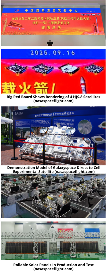
– Graphics released with this launch include renderings of the four satellites. I believe this is a first for the Guowang (SatNet) program. The satellites appear to be of the flat-stackable type (my term).
– The fourth satellite is likely a technology experimental satellite developed by the commercial aerospace company Galaxy Aerospace. It may be used to test direct to cell services.
- Other releases noted the satellite:
- “is equipped with the world’s first fully flexible rollable solar panel, boasting exceptional features such as lightest weight, smallest stowed volume, highest power generation efficiency, and simplest deployment mechanism.”
- Contains “China’s first Ka-band 8-beam, integrated transceiver and spaceborne phased array antenna, significantly optimizing its size, weight, and power consumption.”
- “Utilizes China’s first integrated flat-panel satellite structure with integrated heat pipes, significantly simplifying the satellite assembly process while significantly improving heat dissipation efficiency and reducing manufacturing costs.”
China: Yaogan-45 Update
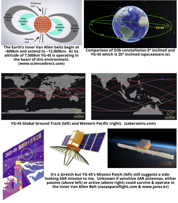
27 Sep 2025: As predicted in the previous Flash, China circularized Yaogan (YG)-45’s (65563) and the satellite is now orbiting Earth at an average altitude of 7,500km. This is China’s first Yaogan satellite in Medium Earth Orbit (defined as 2,000<MEO<35,786km). Traditionally, MEO is used for PNT missions such as GPS or Beidou. There are also communications satellites in this orbital regime, SES operastes 29 O3b satellites at ~8,050km and China has two Smart SkyNet (59705/59706) at ~20,000km.
China has placed YG-45 in an inhospitable environment. At an average altitude of ~7,500km the satellite is right in the middle of the Inner Van Allen radiation belt. The inner Van Allen belt typically extends from an altitude of 600 to 1,000km to approximately 10,000 to 12,000km above Earth’s surface. This belt consists of electrons with energies up to 10 MeV and protons with energies up to ∼700 MeV (compare with estimated values at 500km of 0.04 MeV and 0.1 MeV respectively). At this challenging operational location YG-45 will be consistently exposed to high-energy particles that can damage the antenna’s materials and electronics, shorten its lifespan, and cause signal interference. With proper shielding it is possible to operate satellites for extended periods of time. The aforementioned O3b satellites were first launched in 2013 and are still listed as active in the space catalog. China’s intent to operate YG-45 at 7,500km helps to explain the need for an improved LM-7A capable of lifting 8,000+kg to orbit.
Then there is YG-45’s 20° inclination. At this inclination, YG-45 will never overfly the island of Taiwan as it will only get as close to ~200km to the southern tip of the island (Taipei is about 1,000km north). This inclination is well suited for monitoring the South China Sea, Guam and Hawaii (see graphic).
Chinese official sources noted YG-45 “will be mainly used for scientific experiments, land resource surveys, crop yield estimates, and disaster prevention and relief work”. This mission description matches those provided by other Yaogan satellites with Earth observation (imagery) missions. China has several imaging satellites in GEO (GF-4, GF-13 01, GF-13 02, YG-41 and LudiTance-4 01) so it is very likely they could successfully operate and imaging satellite in MEO. What I don’t know is if it would be possible to operate a SAR imager in the Van Allen belt environment or if the the highly charged environment makes that a practical impossibility. One thing I am certain of is operating an imaging satellite at 7,500km provides a large potential field of view. At this altitude the diameter of YG-45’s maximum field of view (the area of Earth visible from the satellite) of approximately 14,888km. The total area covered would be about 174 million square kilometers, or roughly 34% of the Earth’s surface. By comparison a satellite operating at 600km would have a maximum field of view of 4,800 km in diameter and a potential coverage area of 18 million square kilometers (~10%.)
Absent an image from the first few days of YG-45’s time on orbit when it was in a highly elliptical 200km x 7,500km orbit, attempting to characterize YG-45 will be challenging. Non-earth imaging capable satellites orbit at altitudes of <600km, nearly 7,000km away from YG-45 making high resolution imaging an impossibility.
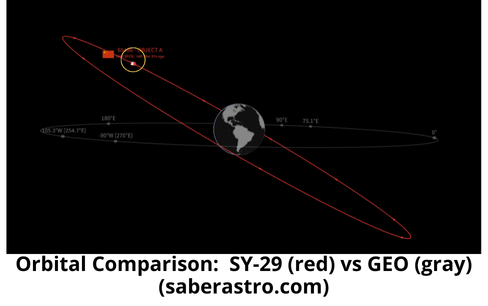
China: SY-29 Update
27 Sep 2025: China’s Shiyan-29 satellite (65486) continues to orbit above GEO. Recall China launched SY-29 on 5 September and we noted that it was in an unusual orbit. SY-29 has an average altitude of 36,185km, which is ~400km greater than the GEO belt. As a result, SY-29 is moving westward 5.4°/day in relation to the Earth’s surface. SY-29 will be over mainland China from ~ 25 Sep – 5 Oct and I’ll be watching to see if China decreases its SMA during that time. SY-29’s inclination of 28.5° is also unusual. China has released little information regarding SY-29’s mission, saying only that the satellite was developed by the Innovation Academy for Microsatellites of the Chinese Academy of Sciences (IAMCAS) and “will be mainly used for space environment detection and related technical tests”. SY-29’s current orbit would support a GEO belt monitoring mission as the satellite would circle the Earth every 67 days. Its inclination give it the potential to monitor other GEO satellites but only for brief periods of time (no RPO if not co-planar). We’ll have to continue to monitor China’s maneuvers of SY-29 to better understand its mission (hopefully).
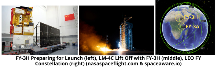
China Launches Newest Fengyun Weather Satellite
26 Sep 2025: China launched a Long March-4C with the FengYun-3H (FY-3H) meteorological satellite from Jiuquan. According to official sources, FY-3H was successfully placed into a Sun-synchronous orbit and is equipped with nine remote sensing payloads and “will primarily support monitoring and research activities in weather forecasting, atmospheric chemistry and climate change”. FY-3H is co-planar with FY-3A, launched in 2008. There are currently 8 FY satellites in LEO. Launch Video.
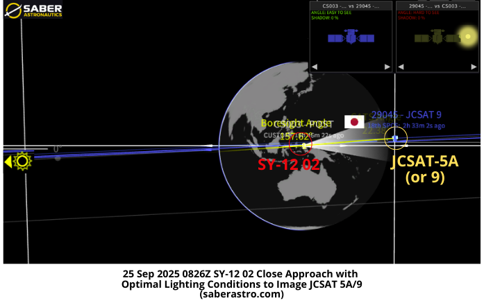
SY-12 02 Conducts Maneuver prior to fly by of JCSAT
24 Sep 2025: Shiyan-12 02 (50322) conducted a minor maneuver to increase its distance from JCSAT 9 (29045). JCSAT 9 is a Japanese commercial communications satellite launched in 2006, and is also listed as JCSAT 5A in some sources. As a result of SY-12 02’s maneuver the point of closest approach between the two objects as SY-12 02 passed by JCSAT 9 increased from 26km to 48km. Per the Joint Commercial Operations Cell (JCO) the slight SMA increase was “more so a drift keep maneuver and is within the historical pattern of life for this object which is often observed to keep a greater than 30km distance between close approaches.”
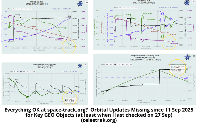
– For whatever reason SY-12 02’s orbital information in space-track.org was last updated on 11 Sep 2025. The following analysis is based on TLE’s provided by JCO.
- SY-12 02 increased its “maneuvered from 132.48 degs E longitude with a delta-v of 0.12 m/s, resulting in a increase in westward drift to 0.558 W degs.”
- “Due to the maneuver the close approach with JCSAT 9 (29045) has increased from 26km to 48km on 25Sep 0825Z.”
- Comparing the TLEs in SBMS, it appears SY-12 increased its SMA ~6km to achieve the desired miss distance of >30km.
-The point of closest approach occurred on 25 Sep 2025 at ~0826Z. At the time, SY-12 02 had optimal lighting conditions to image JCSAT 5A/9 (29045). (see graphic)
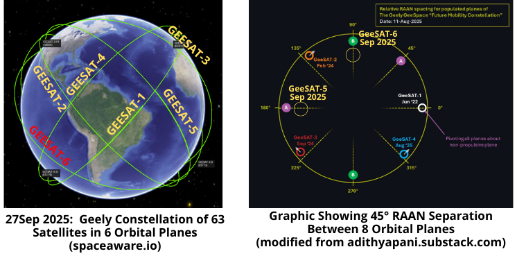
24 Sep 2025: Chinese company Geely, launched its 6th group of satellites (65712-65723) on a Jielong-3 from the waters off the Rizhao coast. This was the third consecutive sea based launch of the Jielong-3 in the past 6 weeks. Cumulatively, the launches placed 33 network satellites and one test satellite into their planned orbits. Per official sources, this launch marks the final leg of the Geely Constellation’s first phase of network deployment. Launch Video.
– Current Status
- With this launch there are now 63 GeeSATs in orbit. All are inclined 50.0° and operating between 550-600km.
- Each launch populated a single orbital plane. Geely has now populated 6 of its planned 8 orbital planes. All are inclined 50° and have 45° RAAN separation. (see graphic below)
- GeeSAT-1 launched 9 satellites on a LM-2C from Xichang in June 2022 (2022-058).
- GeeSAT-2 launched 11 satellites on a LM-2C from Xichang in February 2024 (2024-023).
- GeeSAT-3 launched 10 satellites on a Long March-6 from Taiyuan in Sept 2024 (2024-159)
- GeeSAT-4 launched 11 satellites on a Jielong-3 from off the coast of Rizhoa on 8 Aug 2025 (2025-170).
- GeeSAT-5 launched 11 satellites on a Jielong-3 from off the coast of Rizhoa on 8 Sep 2025 (2025-201)
- GeeSAT-6 launched 12 (11 GeeSATs & 1 experimental) satellites on a Jielong-3 from off the coast of Rizhoa on 26 Sep 2025 (2025-214)
– Per website: “The ‘Geely Future Mobility Constellation’, also known as GEESATCOM and developed by Geespace, is a low Earth orbit (LEO) satellite constellation designed to provide comprehensive global communication and ‘Vehicle-2-Everything’ connectivity services.”
– GEESATCOM deployment is scheduled for three phase implementation.
- Phase 1: 63 satellites (was 72) Phase 1 provides global real-time data communication, while supporting mid-to-low-speed satellite services across multiple sectors, from autonomous driving and smart connectivity.

- Phase 2: 264 additional satellites to enable direct-to-cell communication, extending services to existing mobile phones globally.
- Phase 3: 5,676 multimedia satellites will be added, offering high-speed LEO broadband communication.
– Geely stated they completed Phase 1 deployment goal with 63 satellites. Previously the company had defined Phase 1 as 72 satellites.
- If this is Geely’s final phase 1 launch, their constellation consists of 6 orbital planes with most of the planes separated by a 45° RAAN offset. For example, Group 6 is offset 45° west of Group 2. We had initially estimated Geely’s Phase 1 would consist of 8 orbital planes.
- Three of the Group 2 satellites: 1) GeeSAT-2 03 (58907); 2) -2 04 (58908); and 3) -2 06 (58916)) may have suffered some sort of anomaly as they have not increased their SMA and fallen have out of plane with the other Group 2 satellites.
- GeeSAT -4 09 (65127) is also no longer co-planar with its group. However, in this case -4 09 has actually increased its SMA, indicating the satellite is likely functioning.
Editor’s Comment: GeeSAT is China’s third entry into the proliferated Low Earth Orbit (pLEO) megaconstellation game. It will be interesting to see if the company conducts additional launches through the end of 2025 or is content to begin operations and capability development with the existing 63 on-orbit satellites.