issue 136 | 22 Dec 2025
The integrity flash
Analysis of Developments in the Space Domain
in this issue
China Launches Guowang Groups 14,15 & 16
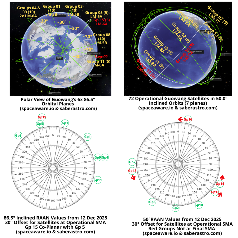
China conducted three separate launches placing 23 Guowang satellites into Low Earth Orbit (LEO). Two of the launches were to 50° inclined orbits while the third was to 86.5°. China now has 130 operational satellites in orbit…3 GEO, 55 LEO 86.5°, and 72 LEO 50°.
6 Dec 2025: China launched a Long March-8A with 9 Guowang Group 14 satellites (66915-66923) from Wenchang. This launch was into a 50° inclined orbit with satellites released at ~875km. Over the next 3-4 months China will gradually raise their altitudes to 1,149.3km. Launch Video.
8 Dec 2025: China launched a Long March-6A with 5 Guowang Group 15 satellites (66953-66957) from Taiyuan. This launch was into a 86.5° inclined orbit with the satellites released at ~1,004km. Over the next 1-2 months China will gradually raise their altitudes to 1,167.9km. Launch Video.
11 Dec 2025: China launched a Long March-12 with 9 Guowang Group 16 satellites (67059-67067) from Wenchang. This launch was into a 50° inclined orbit with the satellites released at ~806km. Over the next 3-4 months China will gradually raise their altitudes to 1,149.3km. Launch Video.
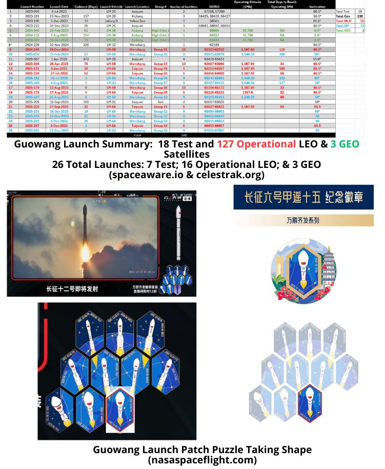
– With Group 14, 15 & 16 launches there are now 127 satellites in the operational LEO Guowang constellation (see graphics & tables). Additionally, there are 3 Guowang satellites in GEO and China has launched 18 Guowang test satellites.
– China is building out the Guowang constellation with orbits inclined either 50.0° or 86.5°. Currently there are 72 satellites in 8 50.0° orbital planes and 55 satellites in 6 86.5° orbital planes. See Table.
– Summary of Guowang Operational Launches
- Group 1 (16 Dec 2024): 10 sats on LM-5B. Orbit inclined 86.5°
- Group 2 (11 Feb 2025): 9 sats on LM-8A. Orbit inclined 50.0°
- Group 3 (28 Apr 2025): 10 sats on LM-5B. Orbit inclined 86.5°
- Group 4 (5 Jun 2025): 5 sats on LM-6A. Orbit inclined 86.5° (co-planar with Group 9)
- Group 5 (27 Jul 2025): 5 sats on LM-6A. Orbit inclined 86.5° (co-planar with Group 15)
- Group 6 (30 Jul 2025): 9 sats on LM-8A. Orbit inclined 50.0°
- Group 7 (4 Aug 2025): 9 sats on LM-12. Orbit inclined 50.0°.
- Group 8 (13 Aug 2025): 10 sats on LM-5B. Orbit inclined 86.5°
- Group 9 (17 Aug 2025): 5 sats on LM-6A. Orbit inclined 86.5° (co-planar with Group 4)
- Group 10 (25 Aug 2025): 9 sats on LM-8A. Orbit inclined 50.0°.
- Group 11 (27 Sep 2025): 5 sats on LM-6A. Orbit inclined 86.5°.
- Group 12 (16 Oct 2025): 9 sats on a LM-8A. Orbit inclined 50.0°
- Group 13 (10 Nov 2025): 9 sats on a LM-12. Orbit inclined 50.0°
- Group 14 (6 Dec 2025): 9 sats on a LM-8A. Orbit inclined 50.0°
- Group 15 (8 Dec 2025): 5 sats on a LM-6A. Orbit inclined 86.5° (co-planar with Group 5)
- Group 16 (11 Dec 2025): 9 sats on a LM-12. Orbit inclined 50.0°.
– Observations
- For the 86.5° inclined orbits (Groups 01, 03, 04, 08, 09, 11 & 15) the operating SMA is 1,167.9km. It appears the intended RAAN separation is ~30° between planes.
- It appears China intends to populate each orbital plane with 10 satellites (at least initially). The LM-5B launches carried a full compliment of 10 satellites to the desired plane. The LM-6A launches deliver only 5 satellites. Group 09’s 5 satellites are co-planar with the 5 Group 04 satellites. China launched Group 15 into a near co-planar orbit with Group 5. By the time Group 15 reaches its operating SMA it will be co-planar with Group 5.
- The 50° orbital planes have 9 satellites and a standard operating altitude of 1,149.3km. The Groups that have reached this SMA (2, 6, 7 & 10) are separated by 30° RAAN offset. Groups 12, 13, 14 & 16 continue to raise their altitudes.
– Deployment Status (all data as of 20 Dec 2025)
- 86.5° Orbits (target SMA 1,167.9km)
- Group 1 reached operating altitude in 110 days.
- Group 3 reached operating altitude in 34 days.
- Group 4 reached operating altitude in 106 days.
- Group 5 reached operating altitude in 58 days.
- Group 8 reached operating altitude in 32 days.
- Group 9 reached operating altitude in 52 days.
- Group 11 reached operating altitude in 54 days.
- Group 15 is currently at 1,003kms.
- 50.0° inclined orbits (target SMA 1,149.3km)
- Group 2 reached operating altitude in 77 days
- Group 6 reached operating altitude in 103 days.
- Group 7 reached operating altitude in 117 days.
- Group 10 reached operating altitude in 86 days.
- Group 12 is currently at 1,052kms.
- Group 13 is currently at 850kms.
- Group 14 is currently at 881kms.
- Group 16 is currently at 806kms.

- Editor’s Comment: Not to be Captain Obvious…but China significantly increased its launch cadence. As anticipated China launched Group 15 into a near co-planar orbit with Group 5 to bring the total number of satellites in that plane to 10 (matching all but one of the other 86.5° planes.) Look for the next 86.5° launch to be co-planar with Group 11. China launched Groups 14 & 16 into new orbital planes.

China Launches 8th & 9th TJS Satellites to GEO
9 Dec 2025: China launched a Long March-3B with the TJS-22 (66990) satellite from Xichang. According to official sources, the satellite entered the planned orbit successfully and “will primarily support services including satellite communication, data transmission, and radio and television broadcasting, as well as conducting relevant technical tests and validations”. On 20 Dec satellite observers noted the satellite had reached geosynchronous orbit and was over 66.5° E with an inclination of 2.0°. At this location it TJS-22 is “near” TJS-2 (41911) which is also at 66.5°E, inclination (0.4°). China launched TJS-2 in 2017 and open source information notes the satellite performs missile warning function. Co-location with TJS-2 may indicate TJS-22 is a replacement for TJS-2…we’ll be watching to see if China re-locates TJS-2 in the coming months. Launch Video.
20 Dec 2025: China launched a Long March-5 with the TJS-23 (SATNO TBD) satellite from Wenchang. According to official sources, the satellite entered the planned orbit and will be “mainly used to carry out multi-band and high-speed communication technology validation tests”. Similar to the YG-41 (58582), TJS-11 (59020) and TJS-20 (66142), China used the LM-5’s the extended fairing (18.5m vs 12.3m) to carry TJS-23 to orbit. Launch Video.
TJS-22 & 23 were the 8th & 9th TJS satellite launches in 2025…previous record was 3 set in both 2021 and 2024.

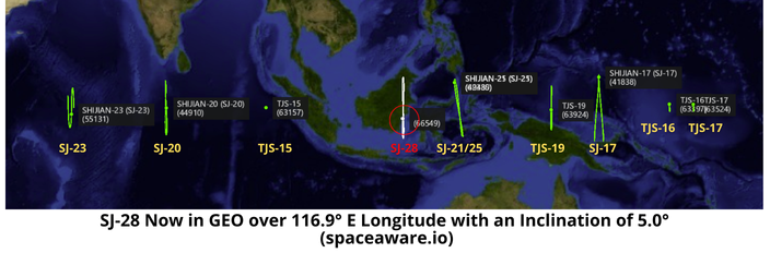
China: Shijian-28 Arrives in Geosynchronous Orbit
8 Dec 2025: After launching Shijian-28 (66549) on 30 Nov on a Long March-7A, China circularized the satellite’s orbit. SJ-28 is now in geosynchronous orbit settled over 116.9° E longitude (over eastern Borneo) and inclined 5°. China has released no information regarding the mission of SJ-28. See below for graphic showing SJ-28’s location/inclination compared with other Chinese GEO satellites of interest. Launch Video.
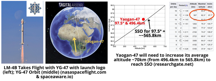
9 Dec 2025: China launched a Long March-4B with the Yaogan-47 (66988) imagery satellite from Jiuquan. According to official sources, the satellite has entered the preset orbit successfully and “will be primarily used in national land surveys, urban planning, road network design, crop yield estimation, environmental management, and disaster prevention and mitigation”. YG-47 is in a nearly sun-synchronous orbit typical for imagery satellites, with an average altitude of 496.4km and an inclination of 97.5°. At this inclination the satellite needs to increase its SMA (average altitude) nearly 70km to reach SSO. Launch Video.
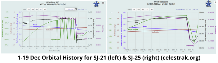
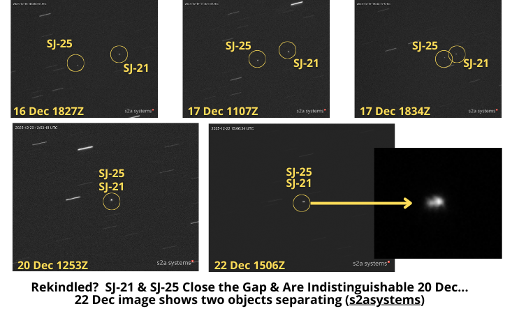
Reps & Sets: SJ-21 & SJ-25 Resume <2km RPO
20 Dec 2025: SJ-21 (49330) and SJ-25 (62485) remain in RPO conditions and were recently within <2km of one another. On 15 Dec the two satellites were ~60-65km apart, then both SJ-25 and SJ-21 maneuvered, SJ-25 on 17 Dec and SJ-21 24hrs later. As a result of these maneuvers the satellites came within 1.3km on 18 Dec (thank you COMSPOC_OPS). Amazing images from s2asystems (thank you Roger!) tell the story. s2asystems 20 Dec image reveals the two satellites are close enough to be indistinguishable from ground based optical telescopes. A final image from 22 Dec shows two objects again. Analysis is ongoing, but at this extreme proximity standard two line element set data (TLEs) are insufficient to identify maneuvers from either spacecraft. Recall the two satellites successfully detached from one another in late-November after presumably docking with one another on 2 July 2025. SJ-21 and SJ-25 have continued to operate “near” one another and were separated by <1km during the 1-5 Dec timeframe. The situation remains fluid and I hope to provide a more granular analysis in the next Flash.


25 Nov 2025: Tahir Azad published an article in Small Wars Journal describing China’s “growing satellite networks, which include navigation, intelligence, surveillance and reconnaissance (ISR), communications, and missile early warning, are creating a ‘kill web’ in space that makes it easier for the PLA’s missile and hypersonic forces to find and shoot down targets.” Excerpts below.
– “Beijing views space integration as the key to achieving information dominance and missile precision, giving it a decisive edge in both deterrence and strike capability.”
– “BeiDou-3 (BDS-3) global navigation network now offers very accurate positioning, navigation, and timing (PNT)…the PPP-B2b service is broadcasting from GEO with real-time positioning accurate to the decimeter level (after convergence).”
– “Ludi Tance-4, the world’s first GEO-based SAR, and Yaogan-41, a high-resolution GEO optical platform, together give us constant, weather-independent views of large ocean and coastal areas…these platforms fuse imagery and signals intelligence into a seamless targeting web that

enables rapid detection, tracking, and strike coordination across maritime and terrestrial theatres.”
– “Yaogan-30 satellites, which are often launched in groups of three, are thought to do ELINT and geolocate ships by measuring the time and angle difference of arrival of their radio emissions…They are used for ocean surveillance and anti-ship targeting. This network tells other sensors and shooters what to do, which lets them kill moving targets like carrier groups and logistics convoys.” Editor’s note: I think the author is actually referring to Yaogan-31.
– “Open-source analysts link the Tongxin Jishu Shiyan (TJS) series in GEO to missile early-warning tests (Huoyan-1) and signals intelligence, which is another part of a growing strategic ISR and warning system.”
– “GEO ISR at scale (SAR + optics)…is perfect for cueing salvos of DF-26/DF-27, timing land attacks and anti-ship strikes, and keeping track of logistics that are spread out.”
– “Guowang & Qianfan aim to provide resilient C2 for distributed forces and unmanned swarms, mirroring lessons from Starlink’s battlefield utility in Ukraine.”
– “Hypersonic-space integration, which includes BDS-3 PNT, space-based ISR cueing, and early warning for missiles, makes it possible to quickly change targets and make decisions more quickly.”
– “The U.S. no longer has an unchallenged edge in precision PNT, exquisite ISR, or sovereign broadband low-Earth orbit (LEO) networks.”
– “China has combined its satellite systems into a powerful force multiplier for missile and hypersonic capabilities. These include BDS-3 for precision, GEO/LEO ISR for persistent targeting, mega-constellations for reliable communication, and counterspace tools to block enemy vision.”
China’s ambitions in the Spratly Islands: Upgrades 2024-2025
By Dr. Larissa Beavers
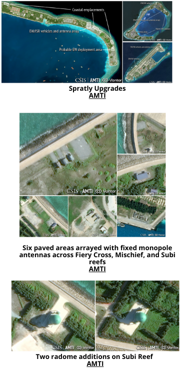
Asia Times reporter Gabriel Honrada states that between 2024 and 2025, China upgraded its Spratly Island outposts into an integrated electronic warfare and sensing network, deploying AI-enabled, networked radars, shipborne sensors, and resilient data-fusion architectures. The Asia Maritime Transparency Initiative states these upgrades allowed PLA forces to resist advanced U.S. jamming, maintain radar tracking, and operate more aggressively in contested environments, with direct implications for U.S. space-enabled operations.
- Spratly Islands (2024–2025): Asia Maritime Transparency Initiative Reported EW Upgrades:
- Installation of new facilities on Fiery Cross, Mischief, and Subi reefs is likely to support vehicle-deployed EW and ISR operations.
- Installation of “at least six paved areas arrayed with fixed monopole antennas” across Fiery Cross, Mischief, and Subi reefs, optimized for unobstructed maritime line-of-sight coverage.
- Antenna sites support groups of mobile EW/sensing vehicles—likely covering different EM bands—with camouflage and dedicated sheltering added by 2025, indicating sustained, multi-band EW operations.
- Mischief Reef uniquely integrates five EW vehicles on linked pads with hardwired connections, while Subi Reef arrays connect to legacy EW sites and point-defense towers, indicating deeper infrastructure integration.
- Construction of nine earth-fortified emplacements on Mischief Reef (2023), indicating preparation for concealed, road-mobile weapon deployments.
- Covered positions suggest flexibility to host artillery, rocket systems, or vehicle-mounted point-defense weapons while denying external observation.
- “A pair of matching radomes was completed on opposite sides of Subi Reef in early 2025.”
- While focused on EM dominance, China is expanding support facilities for potential kinetic roles.
- China’s base upgrades prioritize unmatched ISR and EM control over the SCS, supporting peacetime enforcement and wartime spectrum contestation.

Spratly Islands reporting since 2020 on potential impact to U.S. Space Operations:
- Space-enabled warfare denial: AMTI states China is positioning the Spratly Islands to disrupt U.S. dependence on GPS, SATCOM, and satellite-linked ISR, thereby directly affecting space-to-force integration.
- Ground-based counterspace support: Dr. Fumiko Sasaki author for the Journal of Indo-Pacific affairs claims island-based EW systems complement China’s counterspace strategy.
- Resilient kill-web architecture: CGSR claims integrated maritime and island sensors mirror PLA concepts for space-domain resilience—distributed sensing, data fusion, and redundancy under jamming.
- Submarine bastion shielding tied to space denial: AMTI states that EW and surveillance coverage in the Spratlys helps mask SSBN movements while complicating U.S. space-based maritime domain awareness.
- Cross-domain escalation leverage: Research at Air University suggests China can impose effects on U.S. air, maritime, and space systems below the threshold of kinetic conflict, thereby increasing ambiguity and enhancing control over escalation.
- Exploiting U.S. space-EW integration gaps: CSIC notes that Chinese advances expose U.S. vulnerabilities in training and readiness for operations when space services are degraded or denied.

Jack’s Astro Corner: Meet Lieutenant Clohessey Wiltshire
by Jack Anthony
COMSPOC did a fabulous analyses and explanations and provided some very insightful videos for the 10 Nov 2025 FLASH. I was particularly intrigued with the Cosmos 2581/2582/2583 article and video. Whether you are new to astrodynamics and RPO OR are steeped in this important aspect of Space Domain Awareness (SDA), this article and videos are excellent to learn and comprehend the “what’s going on here.” To that end, here is a short “briefing” by fictitious US Space Force Lt…his name is awesome & he is into RPO big time! 😊For those who missed it here is the COMSPOC VIDEO.
“Hello, my name is Lt Clohessey Wiltshire, I am a Guardian who absolutely enjoys reading the Integrity Flash and especially articles where COMSPOC experts dive into a foreign RPO event. I also wake up each day and do the ”Orbital Element Dance” to get my astro motor running!
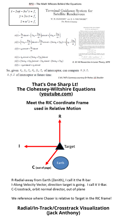
I am going to brief you on a very interesting RPO that occurred on 25 Oct 2025 involving Russian Cosmos 2581 as the Target and Cosmos 2583 as the Chaser. Both spacecraft are orbiting the Earth in pretty much a circular orbit at 585 Km. The video shows 3 Cosmos 2583 “laps” of 2581. By laps I mean “circumnavigations.” Each lap takes about 96 minutes, which is the orbit period of this Russian spacecraft. You will want to focus on 2 things: 1) the path of 2583 about 2581 and in the upper left, the time and distance between the Chaser relative to the target. Each “lap” in the videos takes about 8 seconds. Keep in mind in real time, a lap is 96 minutes. Bet you knew that! This video is speeded up more than 700X. Before we dive into the COMSPOC video, let’s ensure we understand how I will describe the position of the Chaser (2583) relative to the Target (2581). I made an illustration to introduce and explain the “RIC” coordinate frame used in describing relative motion (see graphic). I’ll be using the terms R-bar and V-bar, so be sure to digest the RIC frame.
If you really want to ramp up or refresh your Relative Motion knowledge, watch my two YouTube videos on Relative Motion and re-set the foundation for understanding effects of Radial, In-Track and Crosstrack single impulse maneuver effects, these are 12-minutes each and fun and informative, really!
Video 1 (intro to RIC, Radial and InTrack relative motion)
Video 2 (Cross track motion)
OK, let’s play the video and I will stop it after each circum nav….are you ready? Here goes!
- START video and play to 8 seconds. 2583 is about 2 km on +V bar at the start, it rises relative 2581 and when at about at the +R bar we see it turn Red, that’s a maneuver. It appears to me they are shaping the elliptical shaped relative orbit of 2583. Maybe setting up the close fly-by we’ll see at the end of Rev 2. 2583 returns to +V bar at 1 Km in front. Thus completed first of three relative circumnavs. STOP video at 8 sec. OK, so you see 2583 is flying around 2581, but that maneuver is purposeful, let’s look at Rev 2.
- START video play to 17 seconds. Here we see 2583 extend to a farther -V bar. Then we see 2583 turn red thus another maneuver 0900Z near the V- bar. The last half of this Rev 2 circumnav has 2583 flying by 2581 on the +V bar at 1001Z or so and pretty darn close, like 80 meters close, whoosh! That’s close. STOP Video at 17 sec. OK, so those 2 maneuvers were purposeful, they were perhaps setting up that sub-100 m fly by!
- START Video and play to 25 sec conclusion. The final 8 seconds of the video is the 3rd of 3 circumnavs of 2583 about 2581.
I hope my narration of this excellent COMSPOC video helps you comprehend what’s happening as well as gives you confidence that YOU too can take a RPO related video and play it back for your colleagues or some Generals and help them understand the “what’s going on.” Good luck and thank you.


Thank you for reading this issue of The Integrity Flash
The Integrity Flash is the bi-weekly publication from Integrity ISR’s team of SME’s, delivering expert analysis and clear commentary on the trends, technologies, and challenges that impact the space domain.
The Integrity Flash has over 3,000 subscribers and a secondary readership of over 6,000+ industry professionals.
The Integrity Flash is powered by ISR University, where we deliver operationally grounded training and professional pathways in space, cyber, and intel for U.S. military, allied partners, and industry professionals preparing for real-world missions.


