issue 137 | 19 JAN 2026
The integrity flash
in this issue
China Launches SJ-29A/B
China Launches YG-50 01
Update: TJS-23 Location
Shiyan-12 01 Heads West
Chinese GEO Refueling
Guowang Groups 17 & 18
Fengyun-4C Launch
The Fengyun Constellation
Shiyan-32 & Shijian-30
China Launches Tianhui-7
Russia: Missile Warning
Update: Cosmos 2589
Intelligence suspects Russia is developing Starlink ASAT
Lessons Learned from the Russia - Ukraine Conflict
Jack’s Astro Corner: To the Moon!
Pics o’ the Fortnight
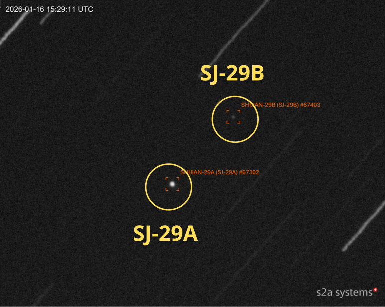
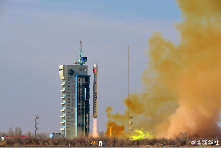
30 Dec 2025: China launched Long March-7A with the Shijian-29A and Shijian-29B satellites (67302 & 67303) from Wenchang. According to official sources, the satellites entered the preset orbit successfully and “will be mainly used for related new technology verification for space target detection”. Interestingly, they share a similar launch date and launch vehicle with the Shiyan-12 01/02 (50321 & 50322) satellites China launched on 23 Dec 2021, which also rode atop a Long March 7A. SY-12 A/B are frequently featured in the Flash as they continuously cruise the GEO belt. China has a tradition of launching “interesting” payloads near the end of the calendar year. Thanks, guys! Launch Video.
– After exiting GTO SJ-29A has settled into GEO at 73.0°E longitude with an inclination of 3.0°. SJ-29A currently has minimal drift from its current position.
-The Joint Commercial Operations cell (JCO) reported that there was a secondary object from this launch. That object has now been cataloged as SJ-29B. JCO reporting noted the SJ-29B was separating from SJ-29A about 7km per day on 10 Jan.
– JCO also reported the secondary object appeared stable and is ~2.5 visual magnitude dimmer than SJ-29A. Passive RF collection also suggests the separated object may be sending radio signals at a frequency of 2218MHz.

-The visual magnitude difference between SJ-29A and the secondary object suggests the vehicles are of different sizes and shapes. See image from the amazing s2asystems.
-The use of the LM-7A may indicate a similar mission as that of the Shiyan-12 01 and Shiyan-12 02 satellites China launched in late-2021. How China operates both satellites should reveal more of their mission.
China launched SY-12 01/02 into a different GEO location (~94.28°E) and inclination 0.5°. So the use of the same launch vehicle may be coincidental.
– As of 12 Jan SJ-29A and SJ-29B were separated 40-53km from one another. The vast majority of this separation is in-track which can be increased/decreased with minor maneuvers.
LM-7A Prepares to Launch SJ-29A/B & Mission Patches. SJ-29A/B On Orbit (nasaspaceflight.org) & s2asystems.com)


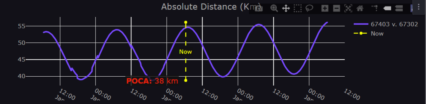
Launch & mission patches (above) (nasaspaceflight.com). Separation Distance Between SJ-29A & 29B Varies from 40-53km (saberastro.com)
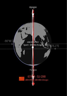
SJ-29A & 29B Orbit Over the Indian Ocean (saberastro.com)
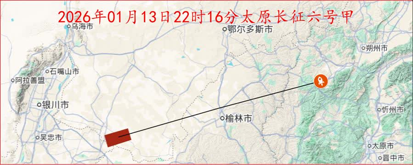
13 Jan 2026: China launched a LM-6A with the Yaogan-50 01 (67433) from the Taiyuan Satellite Launch Center. According to official sources, the satellite “will be used for national land surveys, crop yield estimation, and disaster prevention and mitigation,” which is the generic description China uses for imagery satellites.
China placed YG-50 01 into an unusual retrograde orbit with an inclination of 142° which will reach as far north as 38°N and as far south as 38°S. In retrograde orbit the satellite moves from East to West over the surface of the Earth…opposite of the Earth’s rotation. The effect is to increase the relative velocity (ground speed) of the satellite in relation to the Earth’s surface. Relative velocity is an important factor for Synthetic Aperture Radar (SAR) imagery…the greater the relative velocity the better potential imagery resolution (thank you Jim Shell!). This orbit suggests a SAR imagery capability.
YG-50 01 is orbiting at a higher average altitude (823km) than other imaging satellites, however China has launched 1 SAR imager to GEO (36,000km from Earth) and potentially 2 SAR imagers to MEO (7,500km).
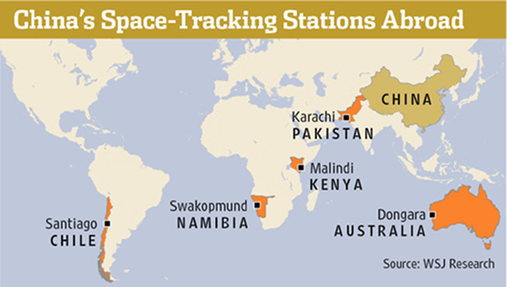
To reach this retrograde orbit China launched the LM-6A westward from Taiyuan and over NW India. To track this launch China likely used its tracking station in Karachi and Yuanwang tracking ships in the Indian Ocean. Finally, China continued its unfortunate pattern of leaving the LM-6A upperstage in orbit with an apogee of 831km and perigee of 546km ensuring this object will remain a hazard to other spacecraft for years to come. Launch Video.
LM-6A Launched West from Taiyuan over China and NW India...awaiting images of 1st stage debris (nasaspaceflight.com)
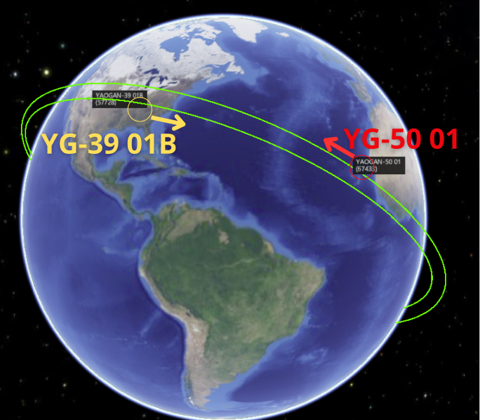
Orbit Visualization Comparing YG-50 01's 142° Inclination and YG-39 01B’s 35° Inclination. (spaceaware.io)
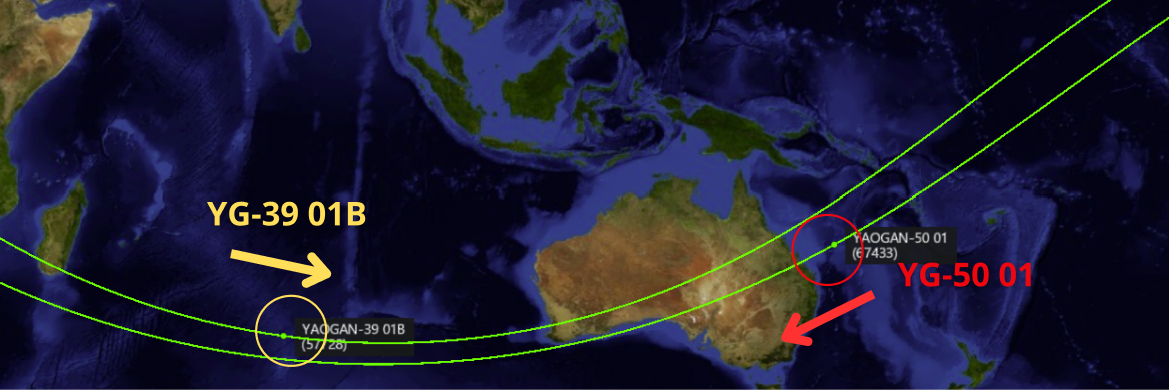
Ground Track of YG-50 01 (142° inclined) & YG-39 01B (35° inclined) Approaching their Southernmost Positions (spaceaware.io)
31 Dec 2025: As noted in the 21 Dec 2025 Flash, China launched a Long March-5 with the TJS-23 (67226) satellite from Wenchang on 20 Dec 2025. We also noted that TJS-23 was just the 4th satellite that used the extended fairing (18.5m vs 12.3m) on the LM-5 to get to orbit (the others were (YG-41 (58582), TJS-11 (59020) and TJS-20 (66142)). According to official sources, the satellite entered the planned orbit and will be “mainly used to carry out multi-band and high-speed communication technology validation tests”. After ~11 days in GTO China circularized TJS-23’s orbit and the satellite is now parked at 175.5°E and inclined 5.98°. In its current orbital slot TJS-23 is between TJS-10 (another extended fairing user) and TJS-6 (believed to be a missile warning satellite.) Launch Video. Watch Video of TJS-23 on orbit.
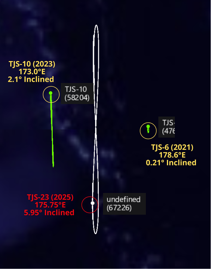
TJS-23 with its Closest TJS Neighbors Over the Western Pacific (spaceaware.io)
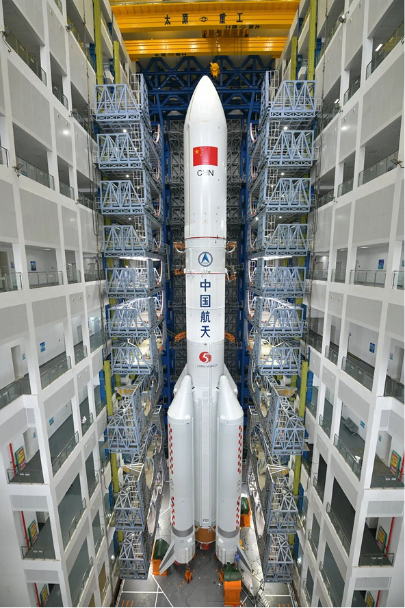
LM-5 with extended fairing prepares for TJS-23 launch (nasaspaceflight.com)
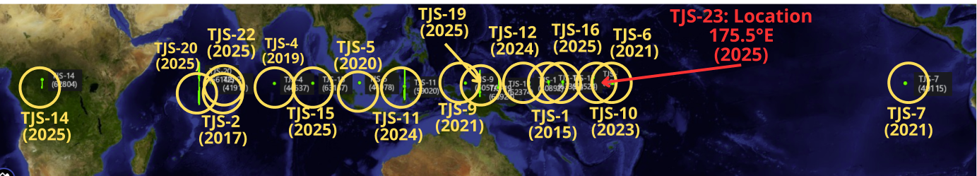
Getting Crowded: TJS-23 Located at 175.5°E between TJS-10 (173.0°E) and TJS-6 (178°E) Spaceaware.io
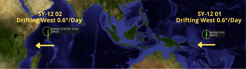
China: Shiyan-12 01 Reverses Course
12 Jan 2026: It’s that time again. China increased the average altitude of its SY-12 01 (50321) inspector satellite ~91km. As a result the satellite changed from drifting East 0.6° per day and is now drifting westward 0.6° per day. China made the maneuver as SY-12 01 approached 170°E, previously China had allowed the satellite to move as far east as 178°E. If China maintains previous patterns, SY-12 01 will drift westward for the next 8-9 months and reverse course when it arrives at 16-19°E longitude. Average leg for SY-12 satellites is 244 days.
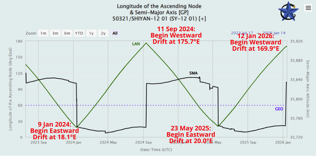
2.5 Yrs of SY-12 01 Orbital History: Average Altitude (black) and Longitude Location (Green) (celestrak.org)
– China launched the SY-12 01 and SY-12 02 satellites on 23 Dec 2021. This is SY-12 01’s 6th change of direction. SY-12 02 has changed direction 5 times.
– SY-12 02 most recently changed directions on 13 July 2025 when it increased its average altitude to begin drifting Westward. SY-12 02 will likely reverse course in mid-March 2026.
– On average the two SY-12 satellites cover from 17.8°E to 175.1°E during each leg of their journey. Average time for each leg has been 244 days.
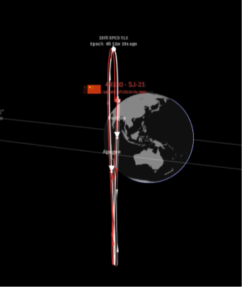
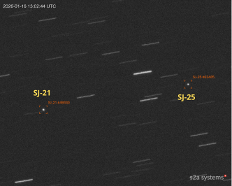
Update: Chinese GEO Refueling
16 Jan 2026: SJ-21 (49330) and SJ-25 (62485) may have exited RPO conditions in mid-January. Before doing so China appears to have used both spacecraft to train on extremely close Rendezvous Proximity Operations (RPO) sometimes referred to as “Zero Prox Ops.” Based on TLE data the two spacecraft were within 1km of one another ~7-8 times from 1-15 January 2026. Quick reminder that TLE data is an average location based on information from several sensors and is not accurate enough for location assessments for GEO objects once they are in close proximity (let’s say <2km). However, after 15 Jan China conducted in-track maneuvers and as of 16 Jan 2026 the two objects were 130km apart. In their current orbits, SJ-25 is separating 50km/day from SJ-21. However, the objects remain co-planar and through minor in-track (easy on fuel) maneuvers could again resume their proximity operations.
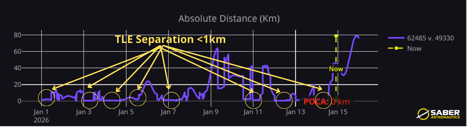
SJ-21 & SJ-25 Closed to within 1km of One Another 8x from 1-15 January 2026 (saberastro.com)
SJ-21 & SJ-25 Visualization (saberastro.com)
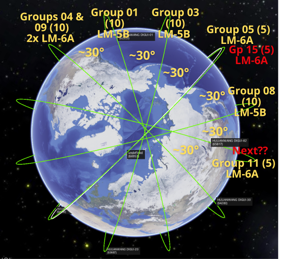
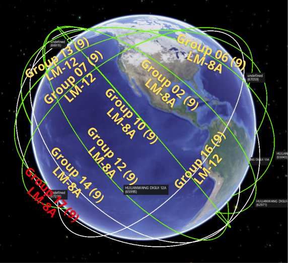
China conducted two separate LM-8A launches and placed 18 Guowang satellites into Low Earth Orbit (LEO). Both of the launches were to 50° inclined orbits and carried 9 satellites each. China now has 148 operational satellites in orbit…3 GEO, 55 LEO 86.5°, and 90 LEO 50°.
26 Dec 2025: China launched a Long March-8A with the 17th group of SatNet LEO satellites (Guowang) from the Hainan Commercial Space Launch Site, at Wenchang. The launch carried 9 satellites (67236-67244) to a 50° inclined orbit with satellites released at ~920km.
Launch Video.
13 Jan 2026: China launched a Long March-8A with the 18th group of SatNet LEO satellites (Guowang) from the Hainan Commercial Space Launch Site, at Wenchang. The launch carried 9 satellites (67435-67443) to a 50° inclined orbit. RAAN estimated to be 294° or about 30° west offset from Group 17. Launch Video.
– With Group 17 & 18 there are now 145 satellites in the operational LEO Guowang constellation (see graphics & tables). Additionally, there are 3 Guowang satellites in GEO and China has launched 18 Guowang test satellites.
– China is building out the Guowang constellation with orbits inclined either 50.0° or 86.5°. Currently there are 90 satellites in 10x 50.0° orbital planes and 55 satellites in 6x 86.5° orbital planes. See Table.
– Launch Summary + number of days to target SMA…1,167.9km for 86.5° or 1,149.3km for 50.0°
- Group 1 (16 Dec 2024): 10 sats on LM-5B. Orbit inclined 86.5° (110 days)
- Group 2 (11 Feb 2025): 9 sats on LM-8A. Orbit inclined 50.0° (77 days)
- Group 3 (28 Apr 2025): 10 sats on LM-5B. Orbit inclined 86.5° (34 days)
- Group 4 (5 Jun 2025): 5 sats on LM-6A. Orbit inclined 86.5° (with Gp 9) (106 days)
- Group 5 (27 Jul 2025): 5 sats on LM-6A. Orbit inclined 86.5° (with Gp 15) (58 days)
- Group 6 (30 Jul 2025): 9 sats on LM-8A. Orbit inclined 50.0° (103 days)
- Group 7 (4 Aug 2025): 9 sats on LM-12. Orbit inclined 50.0°. (117 days)
- Group 8 (13 Aug 2025): 10 sats on LM-5B. Orbit inclined 86.5° (32 days)
- Group 9 (17 Aug 2025): 5 sats on LM-6A. Orbit inclined 86.5° (with Gp 4) (52 days)
- Group 10 (25 Aug 2025): 9 sats on LM-8A. Orbit inclined 50.0°. (86 days)
- Group 11 (27 Sep 2025): 5 sats on LM-6A. Orbit inclined 86.5°. (54 days)
- Group 12 (16 Oct 2025): 9 sats on a LM-8A. Orbit inclined 50.0° (85 days)
- Group 13 (10 Nov 2025): 9 sats on a LM-12. Orbit inclined 50.0° (TBD)
- Group 14 (6 Dec 2025): 9 sats on a LM-8A. Orbit inclined 50.0° (TBD)
- Group 15 (8 Dec 2025): 5 sats on a LM-6A. Orbit inclined 86.5° (with Gp 5) (TBD)
- Group 16 (11 Dec 2025): 9 sats on a LM-12. Orbit inclined 50.0°. (TBD)
- Group 17 (25 Dec 2025): 9 sats on LM-8A. Orbit inclined 50.0°. (TBD)
- Group 18 (13 Jan 2026): 9 sats on LM-8A. Orbit inclined 50.0° (TBD)
Polar View of Guowang’s 6x 86.5° Orbital Planes (spaceaware.io & saberastro.com)
81 Operational Guowang Satellites in 50.0° Inclined Orbits (9 planes) Group 18 not shown. (spaceaware.io & saberastro.com)
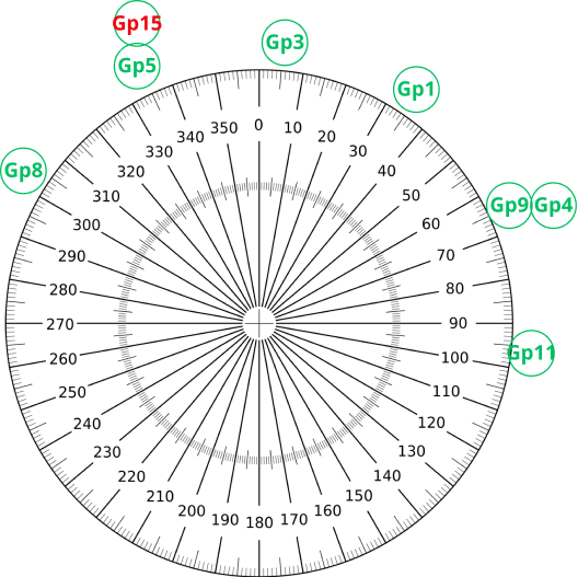
86.5° Inclined RAAN Values from 11 Jan 2026 30° Offset for Satellites at Operational SMA (spaceaware.io & saberastro.com)
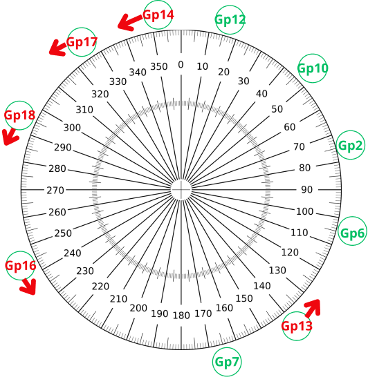
50°RAAN Values from 11 Jan 2026 30° Offset for Satellites at Operational SMA Red Groups Not at Final SMA (Gp 18 estimated) (spaceaware.io & saberastro.com)
Guowang Launch Summary: 18 Test and 145 Operational LEO & 3 GEO 28 Total Launches: 7 Test; 18 Operational LEO; & 3 GEO (spaceaware.io & celestrak.org)

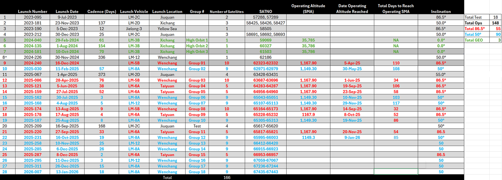
26 Dec 2025: China launched a Long March-3B rocket with the FengYun-4C (67246) meteorological satellite from Xichang. FengYun-4C will operate in GEO over 133°E longitude. The same sources report FY-4C is the replacement for FY-4A which has been in GEO since 2016. Launch Video. Watch Promo Video.
– FY-4C is a 5,300kg satellite which will support China’s National Satellite Meteorological Center (NSMC).
– Per the NSMC, FY-4C “will replace the FY-4A satellite, which has exceeded its service life in orbit”
– Fengyun-4C is planned to be in operation for the next eight years, and will be located at 133°E longitude “with an observation area ranging from 68°E longitude to 162°W longitude, covering most of my country <China> and the Asia-Pacific region.”
– FY-4A, the satellite FY-4C is replacing. is located at ~124°E longitude, it will be interesting to see if China leaves the satellite in place or increases its SMA to place it into a graveyard orbit.
– Per China In Space: “The Shanghai Academy of Spaceflight Technology stated that they developed Fengyun-4C and added that new capabilities are onboard, like small electric hall-effect thrusters, installed on manipulatable arms, for fine orbital adjustments. Improved space-to-ground communications were noted alongside the capability for space-to-space-to-ground7 communications in the near future.”
– FY-4C is the 3rd satellite in the geostationary Fengyun-4 series (a follow up from the FY-2 series).
– Readers may be most familiar with FY-1C which China destroyed with a Direct Ascent ASAT missile in 2007. Thousands of pieces of debris remain in orbit from that test and will be a threat for generations to come (nice going guys).
– This is the second FY satellite China has launched in 2025. They also launched FY-3H into a LEO sun-synchronous orbit on 26 Sep 2025.
– There are currently 13 active Fengyun satellites in orbit (including FY-4C). 5 in GEO and 8 in LEO.
- LEO
- FY-3A (2008); FY-3B (2010); FY-3C (2013); FY-3D (2017); FY-3E (2021); FY-3F (2023); FY-3G (2023); FY-3H (2025)
- GEO
- FY-2G (2014); FY-4A (2016); FY-2H (2018); FY-4B (2021); FY-4C (2025)
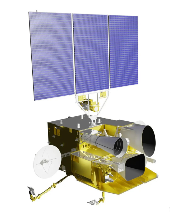
Artist Rendering of FY-4C (above), LM-3B Prepares for Liftoff w/ FY-4C (below) (nasaspaceflight.com)
A Closer Look at the Fengyun Constellation
29 Dec 2025: Did I take the FY-4C launch as an opportunity to look at the Fengyun weather satellite constellation during the winter holidays? Why yes, yes I did! Please see below for some helpful graphics. FY-4C has settled into its orbital slot at 133.0°E with an inclination of 0.1°. For now FY-4A remains in its operational orbit.
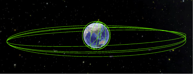
Family Portrait of the Fengyun Constellation: Currently China has 5 GEO and 8 LEO satellites (spaceaware.io)
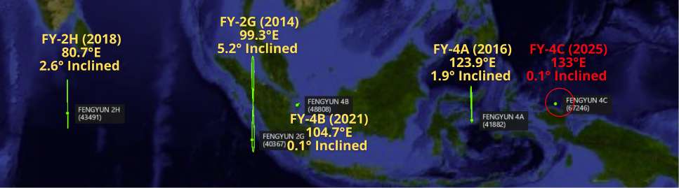
Locations and Inclinations for Fengyun GEO Satellites (spaceaware.io & celestrak.org)
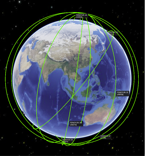
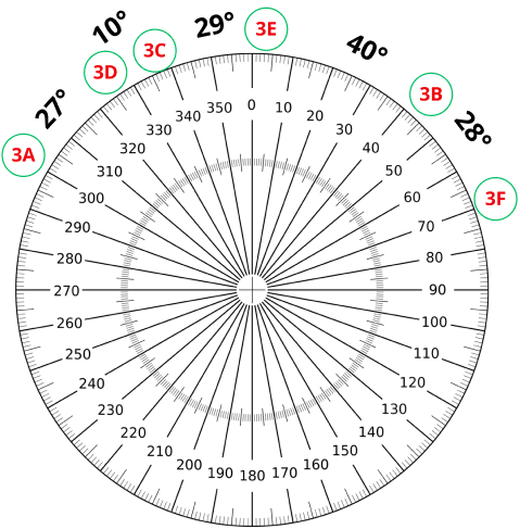

7 of 8 Fengyun satellites are in polar orbit with variable RAAN offsets (above). FY-3G is inclined 50°. Approximate Coverage of Beijing for 24hrs (below) (spaceaware.io & saberastro.com)
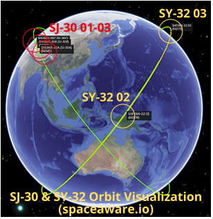
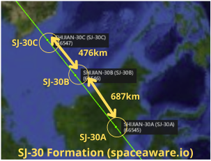
Checking in on Shiyan-32 & Shijian-30 Triplets
14 Jan 2026: In November 2025 China launched two sets of 3 satellites into nearly co-planar orbits with dozens of Starlink and Amazon LEO satellites. On 8 Nov 2025 China launched Shiyan-32 01-03 (SY-32) (66376, 66377 & 66378) into a 450x432km 53.0° inclined orbit. 11 days later China launched Shijian-30 A-C (SJ-30) (66545, 66546, & 66547) into a 51.8° inclined orbit with average altitudes ranging from 519.6-520.6km. Since their launch, all three SJ-30 satellites have maintained their average altitudes at ~520km. Two of the SY-32 satellites, SY-32 02 & 03, have maneuvered but are operating at different SMA values and thus not maintaining their relative position with one another (editor’s note: this may not be an anomaly, the two spacecraft could be carrying out their mission independently of one another). LeoLabs has confirmed the release of a sub-satellite (Object E, 67225), from the Chinese spacecraft Shiyan 32-02 on 17 December. SY-32 01 has not maneuvered since arriving on orbit and may have failed. Finally, Starlink has announced plans to reduce the altitude of roughly half of their 9,400 operational satellites from 550km to 480km.
– SY-32:
- SY-32 01 may be dead. It has not maneuvered since arriving on orbit and has lost 10km in altitude.
- SY-32 02 increased its SMA nearly 20km on 18 Dec 2025. It is now orbiting at an SMA of 445.8km.
- SY-32 03 has conducted 3 maneuvers, combined they have increased SY-32 03’s SMA to 442.3. Unclear why SY-32 03 if following a different maneuver pattern than SY-32 02.
- Object E has not maneuvered and rapidly lost altitude. Its first catalog entry recorded the object at 403km on 19 Dec. By 22 Dec the object had declined nearly 75km to 328km. There are no further catalog entries, it is possible the object may have re-entered.
– SJ-30: It appears China intends to operate the SJ-30 satellites in formation. All three satellites have maneuvered 3-5 times and are maintaining a nearly identical SMA of 519.8km.
– Starlink:
- Per space.com article: “There are two main reasons for the move, according to Michael Nicolls, vice president of Starlink engineering…’As solar mininum approaches, atmospheric density decreases, which means the ballistic decay time at any given altitude increases — lowering will mean a >80% reduction in ballistic decay time in solar minimum, or 4+ years reduced to a few months…Correspondingly, the number of debris objects and planned satellite constellations is significantly lower below 500 km, reducing the aggregate likelihood of collision.’”
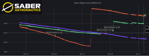
SY-32 SMA Comparison 01/Blue, 02/Red & 03/Green (saberastro.com)
30 Dec 2025: China launched a Long March-4B with the Tianhui-7 (TH-7) mapping satellite (67300) from Jiuquan. TH-7 is currently in LEO at 485.2km and inclined at 97.42°. Including TH-7 there are now 15 active Tianhui satellites in orbit (all LEO…although TH-1 02’s demise appears imminent). The TH-7 orbit appears similar to that of TH-1 04 (49049) which launched in 2021. Launch Video.
– TH-7’s inclination and SMA resemble those of the TH-1 series. The TH-1 satellites also operated as single satellites, while China launched the TH-2, TH-4, TH-5 and TH-6 satellites in pairs and operate them in formation.
– The Tianhui-1 (or “sky drawing”) constellation of satellites are Earth observation satellites built by Dong Feng Hong and operated by the People’s Liberation Army.
– The Tianhui 1 series of satellites began launching in 2010 with the launch of Tianhui 1-01.
– Tianhui 1-02 and 1-03 were launched in 2012 and 2015 respectively.
– TH-1 04 is the only TH-1 series to remain operational. TH-1 01 & 03 have de-orbited and TH-1 02 will de-orbit in the next few weeks.
-Per Gunter’s: TH-1 satellites are “equipped with a three-dimensional survey camera and a CCD camera with a ground resolution of 5 meters…with a camera angle of 25 degrees. Also on board is a multi-spectral camera with a ground resolution of 10 meters…(with a) swath width of the cameras is 60 kilometers wide.
– Assuming TH-7 is a follow-on to the TH-1 satellites it is likely equipped with improved optical sensors.
– Initial observations show TH-7 orbiting at ~10km lower average altitude than TH-1 04 and TH-7 has a 4.2° east RAAN offset with TH-1 04.
– If China were to raise TH-7’s orbit to match that of TH-1 04 the two satellites would maintain their relative positions to one another and enable cooperative operations. (Editor’s note: I have no indications this is planned, just pointing out the possibility. Time will tell.)
Love the smell of Hypergolics in the Morning. LM-4B lift off with TH-7 producing Yellow/Orange toxic cloud. (nasaspaceflight.com)
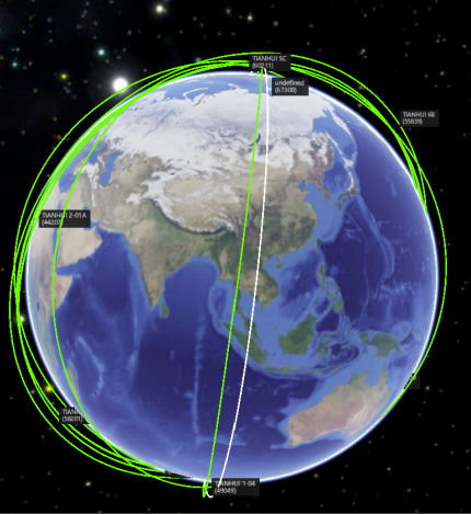
Visual Comparison Between TH-1 04 and TH-7 Orbits. TH-7 currently has RAAN offset of 4.2° E to TH-1 04 (spaceaware.io & saberastro.com)

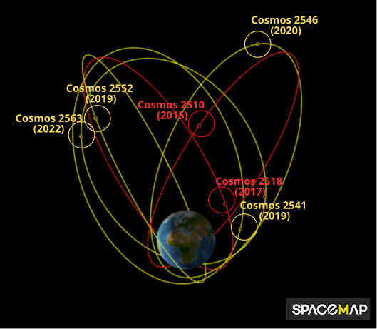
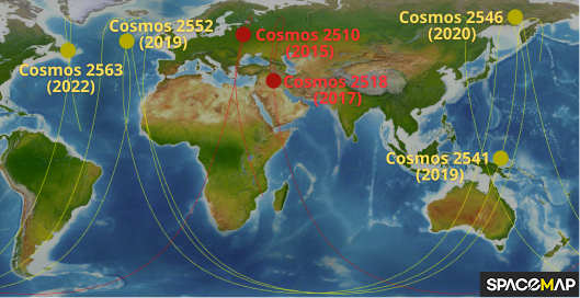
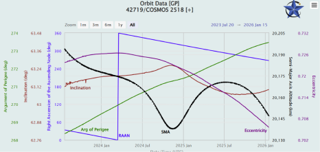
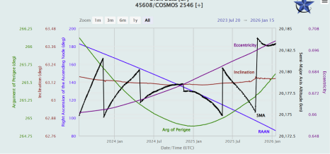
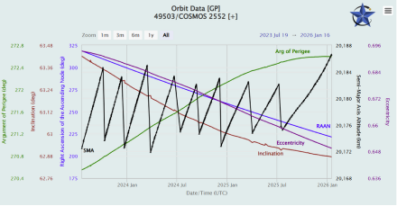
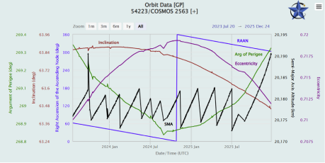
5 Jan 2026: Russia appears to be struggling to maintain its 4-satellite missile warning constellation. The Tundra/Kupol constellation was meant to consist of 8-10 satellites (as it had in the 1980s under the Soviet Union) however only 6 have launched: 1) Cosmos 2510 (2015/41032); 2) Cosmos 2518 (2017/42719); 3) Cosmos 2541 (2019/44552); 4) Cosmos 2546 (2020/45608); 5) Cosmos 2552 (2021/49503); and 6) Cosmos 2563 (2022/54223). Cosmos 2510/2518 have not maneuvered in the past 30 months. Cosmos 2541/2546 both last maneuvered in mid-October 2025 (slight deviation from norm). Cosmos 2552 has also deviated from its pattern of life having last maneuvered in July 2025. The newest satellite, Cosmos 2563, last maneuvered in Aug 2025, another pattern of life deviation. There have been suggestions that all 6 satellites have become non-operational, however Cosmos 2541/2546/2552/2563 continue to emit radio signals and appear in stable condition (Cosmos 2510/2518 are most likely non-operational). Thankfully (for me) there has been some excellent analysis from Pavel Podvig, Anatoly Zak, Scott Tilley and Jonathan McDowell to explain what might be happening.
– From Anatoly Zak:
- “Russia’s full-scale invasion of Ukraine in February 2022, seemingly coincided with the quick decay of the space assets complementing Russia’s early warning system about missile launches, which the Kremlin spent decades trying to rebuilt after the fall of the USSR.”
- “After the launch of the 6th Tundra satellite in 2022, the Russian military seemingly gave up on the effort to deploy the EKS early warning constellation or, possibly, the industry was simply unable to build new satellites due to technical problems associated with Western sanctions and/or financial problems.”
- Zak Quoting Scott Tilley: “Given the fact that the entire quartet of still-surviving satellites, including Kosmos-2541, -2546, -2552 and -2563, started its westward shift around September 2025, it could be a coordinated constellation-wide move, while the overall system could still perform its duties.”
Russian Missile Warning Constellation 3D (top) and 2D (below) Overview ( (spacemap42.com)
- “That hypothesis was supported by the fact that the four satellites continued transmitting the usual radio signals in X-band, associated with active satellites, while the optical observations detected no flares often associated with tumbling objects having lost their attitude control, thus indicating that all the satellites remained in stable position.”
- “One possible explanation for this odd behavior might be orbit-maintenance operations switching from traditional hypergolic thrusters to the more fuel-efficient but lower-thrust SPD-100 electric engines in an effort to conserve propulsion capabilities and thus extend the life-span of the satellites. It should be noted that such an approach would be particularly logical if no replenishments were expected to be launched into the system in the immediate future. As a result, the flight controllers might have decided to tolerate considerably wider East-West deviations of the satellites from their operational positions, while still maintaining the general arrangement of the constellation in orbit.”
Editor’s Comment: Russia likely maintains 4 operational missile warning satellites. For the missile warning mission it is desirable to have “dual ball” coverage, that is having two satellites near apogee at around the same time in order to improve detection confidence and missile trajectory prediction (we saw this recently with China’s recent missile warning launches). Cosmos 2546 and 2552 appear to be paired up as do Cosmos 2541 and 2563. Due the orbital stability resulting from the 63.5° inclined Molniya orbit (slow RAAN and Argument of Perigee changes) Russia will likely be able to maintain functionality (at least from being in a useful orbit) for the near-medium term.
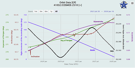
Cosmos 2510: No Maneuvers 2.5yrs (celestrak.org)
Cosmos 2518: No Maneuvers 2.5yrs (celestrak.org)
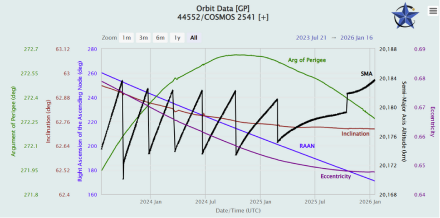
Cosmos 2541 Orbital History Maneuver Pattern Change (celestrak.org)
Cosmos 2546 Orbital History Maneuver Pattern Change (celestrak.org)
Cosmos 2552 Orbital History Maneuver Pattern Change (celestrak.org)
Cosmos 2563 Orbital History Maneuver Pattern Change (celestrak.org)
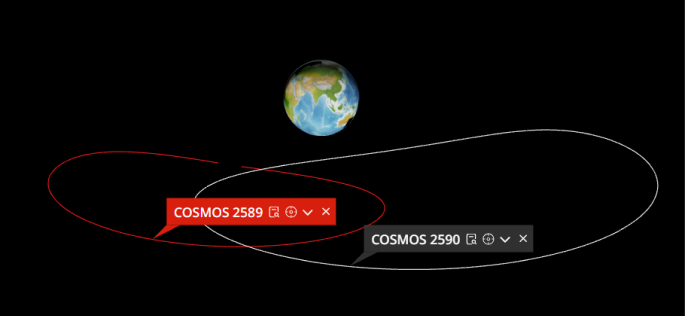
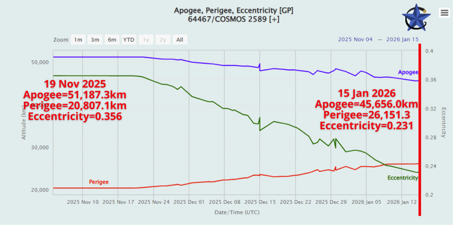
16 Jan 2026: As noted in the 7 December 2025 Flash, Cosmos 2589 (64467) began conducting maneuvers to circularize its orbit on 19 Nov 2025 when it began lowering its apogee and raising its perigee. This trend continues and as a result Cosmos 2589’s eccentricity has dropped from 0.364 to 0.231 (0.0 = perfect circle). To date, Cosmos 2589 apogee has decreased ~5,500km and its perigee has increased 5,340km. Russia continues conducting in-track maneuvers every 12hrs and is likely to continue to do so until Cosmos 2589’s orbit has circularized, at which time it will be in proximity with the Geostationary belt. From this orbit it will be able to patrol GEO and potentially conduct inspection missions. Cosmos 2589’s RPO partner, its subsatellite Cosmos 2590 (64527), has not maneuvered since early-December 2025. The two satellites now briefly cross paths twice per orbit (see graphic).
Cosmos 2589’s Orbit Continues to Circularize (get skinny in this view), while Cosmos 2589 remains consistent (spacemap42.com)
Cosmos 2589 Orbit History Showing Steady Increase in Perigee and Decrease in Apogee Resulting in Declining Eccentricity (celestrak.org)
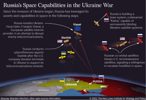
By Dr. Larissa Beavers
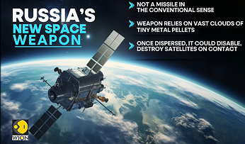
PBS News reports two NATO intelligence services suspect that Russia is developing an anti-satellite weapon specifically designed to disrupt or disable SpaceX’s Starlink satellite constellation, a system that has become critical to both civilian connectivity and modern military operations. The reporting highlights growing concern that commercial space systems are now treated as legitimate military targets, blurring the line between civilian and defense infrastructure in orbit. If deployed, such a capability would mark a significant escalation in counterspace threats and further reinforce space as a contested operational domain. The development also raises alarms about debris creation, escalation dynamics, and the resilience of space-enabled command and control.
Impact to Space Operations:
- Targeted counterspace threat: PBS news reports Russia is suspected of developing an ASAT capability aimed at Starlink.
- Commercial systems no longer neutral: Military-supporting constellations are treated as legitimate targets.
- Debris risk: Kinetic or area-effect attacks in LEO could create widespread, long-lasting debris threatening satellites beyond the intended target.
- LEO degradation: NATO reports suggest debris-producing attacks could disrupt orbital operations for years.
- Operational impact: Starlink disruption would affect military C2, ISR dissemination, and logistics.
- Escalation risk: Attacks on commercial satellites blur proportional response thresholds.
- Resilience pressure: Operators may accelerate redundancy, reconstitution, and hardening.
- Traffic management strain: Contested LEO complicates collision avoidance and maneuvering & possibly small enough making it difficult to track.
- Norm erosion: Such weapons further undermine international space norms.
- Experimental: Some analysts doubt it could work without significant risks to the space domain and Russian space assets.
WION – Russia’s New Space Weapon

Editor’s Comment: The wartime utility of such a weapon is questionable. While undoubtedly catastrophic to several orbital planes and the LEO orbital regime in general, the release of debris clouds would have unpredictable results in terms of timeliness and effect. These tactics would also endanger non-targeted satellites, some of which belong to Russia and other nations such as China. Then again, it is Russia, so you never know.
Lessons Learned from the Russia - Ukraine Conflict
By Dr. Larissa Beavers
The CNA report “Russian Concepts of Future Warfare Based on Lessons from the Ukraine War” examines how Russian military elites’ strategic and operational thinking has evolved after three years of high-intensity conflict in Ukraine, finding that core Russian warfighting concepts have changed little despite significant tactical innovations on the battlefield. Russian thinkers view the Ukraine war as confirming pre-existing strategic assumptions, and they continue to prioritize long-range precision strike, combined arms maneuver, and air dominance concepts. While technological advances—especially uncrewed systems—have altered the character of conflict tactically, no fundamental doctrinal shifts have emerged at the strategic level. This persistence suggests that future Russian planning will build on traditional frameworks rather than wholly new concepts.
Summarized CNA lessons-learned that intersect with space-enabled capabilities::
- Russian emphasis on battlefield transparency highlights the value of ISR, including space-based sensors for detection and targeting.
- Continued focus on long-range precision strike implies reliance on space-enabled communications, navigation, and targeting support.
- The widespread use of uncrewed systems highlights the increasing need for space-supported ISR feeds and C2 links.
- Tactical innovations still depend on real-time intelligence, which in modern war is often derived from space assets.
- The persistence of traditional concepts despite battlefield lessons reinforces the need for space resilience and redundancy.
- Even as ground and air components adapt, space remains central to indications & warning (I&W) and integrated warfighting concepts
- Sustained high-intensity conflict reinforces the need for resilient PNT and SATCOM to maintain operations when terrestrial networks are degraded.
- Integrated fires, maneuver, and ISR show that space-enabled kill chains are critical for cross-domain synchronization in contested environments.

Space-enabled kill chains in action
AI generated image

Jack’s Astro Corner: To the Moon!
By Jack Anthony
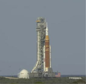
Editor’s Comment: Jack was nice enough to put together an article examining the upcoming Artemis 2 mission currently scheduled to launch as soon as 6 Feb 2026. Thank you again Jack!
10 Jan 2026: We are 1 week from NASA rolling out the Artemis 2 rocket (SLS) and Orion space capsule (editor’s comment: SLS rolled out to the pad on 17 Jan 2026). Launch is still planned for early February. Have you ordered your Artemis 2 hoodie on sweatshirt? I have. OK, in an effort to make you most awesome at the dinner table, in the workplace, or school, here’s a blurb on the Artemis 2 Earth orbits they will do BEFORE heading for the Moon on a free-return 3-body orbit (astro dynamos use cool words, you can too). Enjoy and whatcha think of my retro NASA attire, cool 1960’s look?

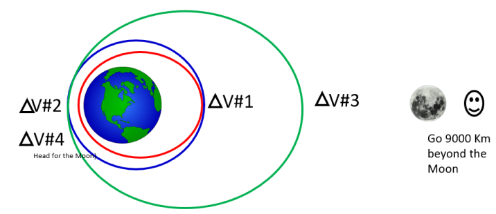
Here’s a review of the Artemis 2 orbits around the Earth before the Orion and crew head for the Moon on a Free-Return trajectory. I use altitude perigee x altitude apogee to denote low and high points of the orbit (I use Km).
Artemis 2 is launched into the RED orbit from Kennedy Space Center into a 25 km x 2200 Km orbit. Now that 25 Km low point (called perigee) is not so good, the atmosphere would cause trouble on the first perigee pass.
So Delta V#1 occurred about 45 minutes into the flight and puts Artemis 2 on the blue orbit 185 km x 2200 Km. Ahhh, much better!
Then at Delta V#2 a big maneuver is executed to raise apogee to 70000 Km (that’s twice as high as geosynchronous satellites operate. This 185 km x 70000 Km has a 24-hr period in an elliptical orbit (egg shaped). In this orbit they will execute rendezvous and proximity operations with the Interim Cryo Propulsion Stage (ICPS) which they separate from and is tagging along in a 2 spaceship formation. They will do a bunch of orbital dancing (RPO is dancing in space, really!).
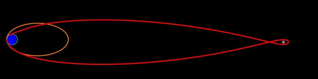
Delta V#3 is a small tweak to the perigee altitude in preparation for the Trans Lunar Insertion (TLI) that is 12 hrs away at that point. TLI is the Delta V#4 that sends Orion and crew on their way to the Moon in a free-return trajectory. That means they will reach the Moon, pass beyond it and be slung back to Earth. It’s using what astro enthusiasts call a 3-body orbit (Earth, Moon and wee little spaceship). That free return trip takes 4 days out, 4 days back. 10-day mission! Enjoy your new knowledge, so explain it to someone!