ISSUE 141 | 23 mar 2026
The integrity flash
In This Issue
Ships Passing in the Equinox: TJS-3 & TJS-10 Cross Paths
China Launches Second Yaogan-50 into Retrograde Orbit
China Launches Guowang Group 20
China Launches Shiyan-30 03 & 04 Satellite
China: Shiyan-12 02 Reverses Course
Out of Formation: YG-31A/B/C Stumbles
China Adopts 15th Five-Year Plan
Russian Intelligence Support to Iran
BeiDou on the Battlefield: Iran’s Use of China’s BeiDou
Pics o’ the Fortnight

Ships Passing in the Equinox: TJS-3 & TJS-10 Cross Paths
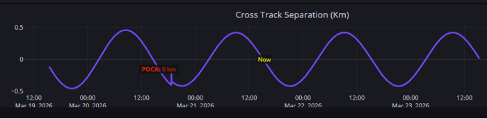
21 Mar 2026: At ~1550Z on 20 Mar, TJS-10 (58204) and TJS-3 (43874) passed one another in GEO over ~91.5°E longitude. Neither satellite maneuvered (at least as of 1600Z on 21 Mar) and TJS-10 continues to head west while TJS-3 creeps eastward. Many will recall that Chinese space operators maneuvered both satellites in early February 2026 resulting in the two satellites heading toward one another. At the point of closest approach (POCA) the satellites were ~220km apart with the majority of the separation due to differences in radial track. At POCA TJS-3 had ideal lighting conditions for imaging TJS-10, although with ~220km of separation it seems unlikely China intended to collect high-resolution imagery of either satellite. The satellites remain plane matched (nearly identical inclination and RAAN).
Given the past history of these two satellites, I had anticipated TJS-10 would decrease its SMA prior to crossing paths with TJS-3 and position itself just to the east of TJS-3 as it had in late 2023. We will see if either satellite maneuvers in the coming days to resume some sort of testing or if both continue on their merry ways to destinations as yet unknown. s2a systems was nice enough to put together a time lapse video showing TJS-10 & TJS-3 crossing paths.
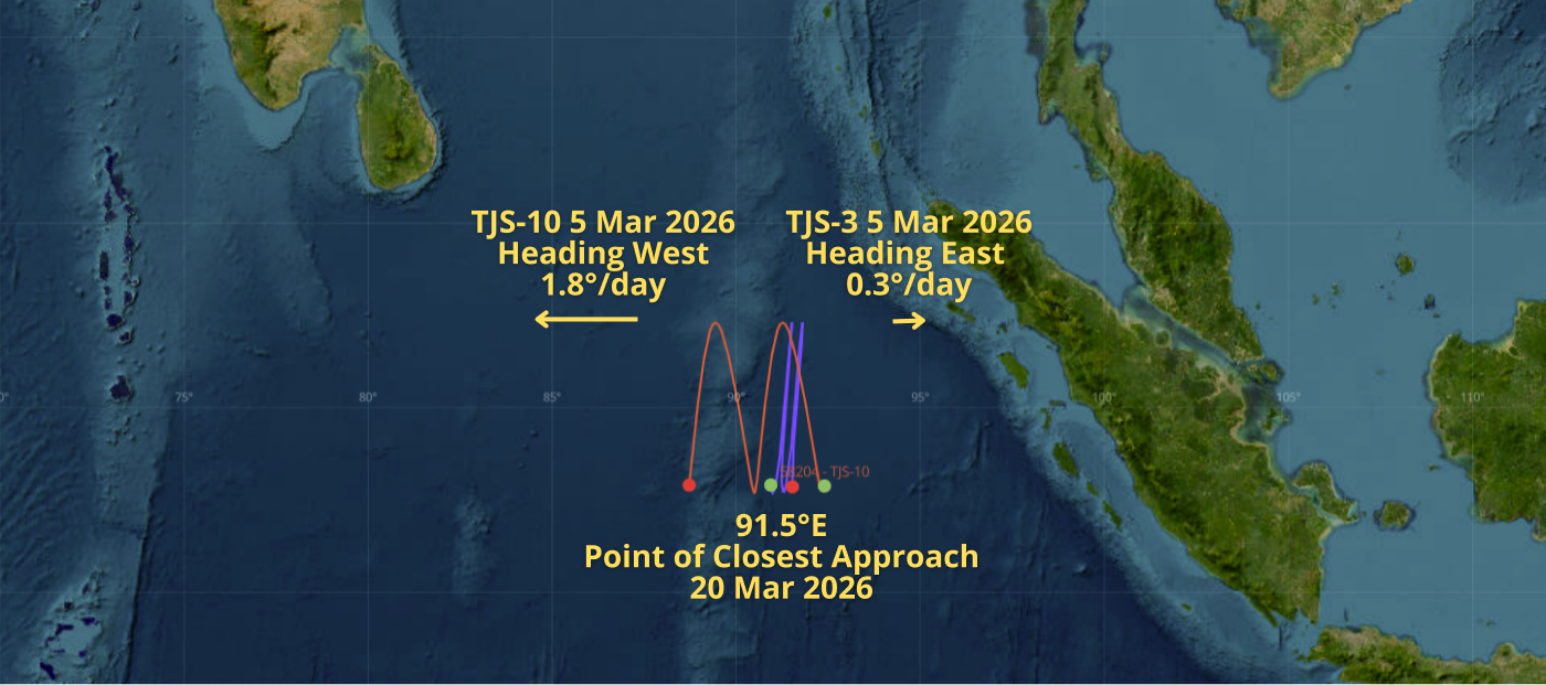
20 Mar 2026 Ground Track for TJS-3 (purple) & TJS-10 (red). (saberastro.com)

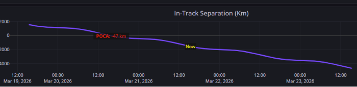
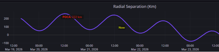
19-23 Mar 2026: TRIC Plot of Separation Distance between TJS-3 & TJS-10 Absolute Separation at POCA ~227km (Radial Separation ~222km) (saberastro.com)
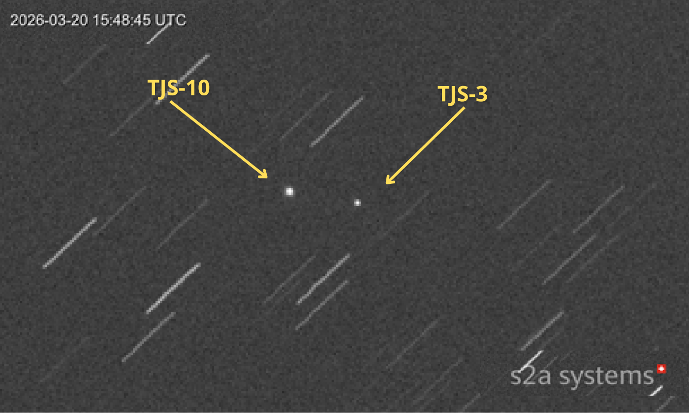
20 Mar: TJS-3 and TJS-10 Near Point of Closest Approach 15:48:45UTC
(s2a systems via X)
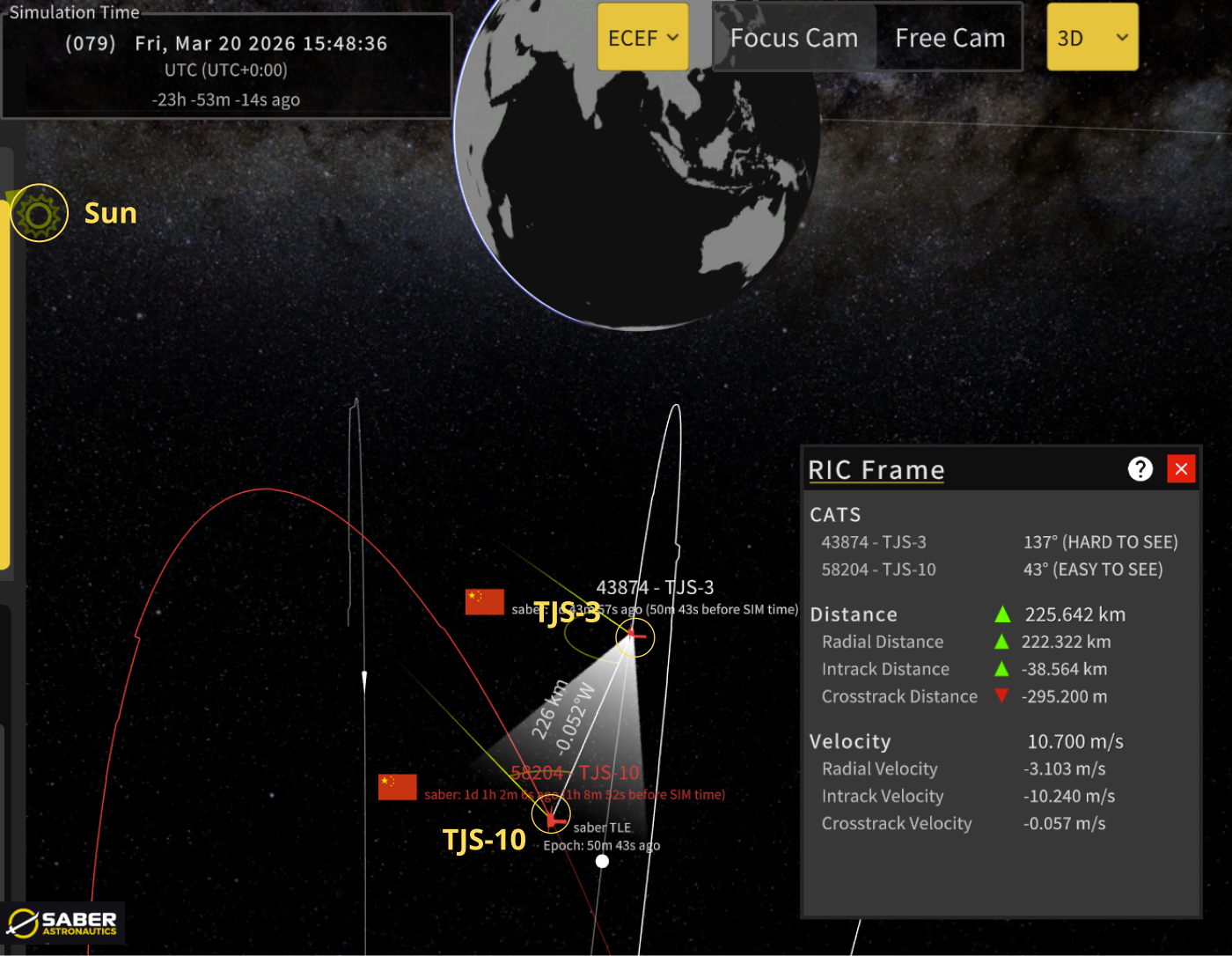
20 Mar 2026 1548Z Orbit Visualization
TJS-3 & 10 Total Separation ~225km, Solar Conditions Ideal for TJS-3 Observation of TJS-10 (although range makes high resolution imagery unlikely)
(saberastro.com)
15 Mar 2026: China launched a LM-6A with the Yaogan-50 02 (68196) from the Taiyuan Satellite Launch Center. According to official sources, the satellite “will be used for national land surveys, crop yield estimation, and disaster prevention and mitigation,” which is the generic description China uses for imagery satellites. This was the same description China provided for Yaogan-50 01 (67433) launched 13 Jan 2026. YG-50 01 also used a LM-6A from Taiyuan. CAST developed YG-50 02 while SAST developed YG-50 01.
China placed YG-50 02 into a retrograde orbit with an inclination of 142° (identical with YG-50 01) which will reach as far north as 38°N and as far south as 38°S. In retrograde orbit the satellite moves from East to West over the surface of the Earth…opposite of the Earth’s rotation. The effect is to increase the relative velocity (ground speed) of the satellite in relation to the Earth’s surface. Relative velocity is an important factor for Synthetic Aperture Radar (SAR) imagery. This orbit suggests a SAR imagery capability.
YG-50 02’s initial SMA was ~838.7km which China increased to 885.7km by 19 Mar. YG-50 01 increased its SMA ~133km during its first 5 days on orbit and has been operating at 952.4km for the past 60 days. While the two YG-50 satellites have the same inclination they are not co-planar. YG-50 02 has a ~112° west RAAN offset with YG-50 01.
To reach this retrograde orbit China launched the LM-6A westward from Taiyuan and over NW India. To track this launch China likely used its tracking station in Karachi and Yuanwang tracking ships in the Indian Ocean. China again left the LM-6A upperstage in an orbit which will persist for decades…perigee 573km/apogee 836km. Launch Video.
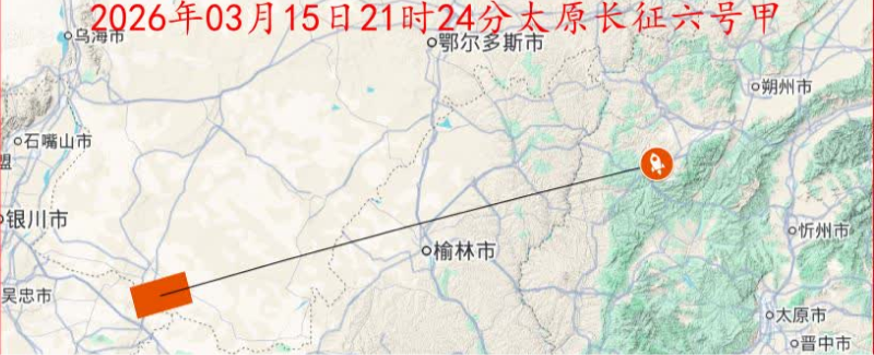
LM-6A Launched W from Taiyuan over China & NW India (nasaspaceflight.com)
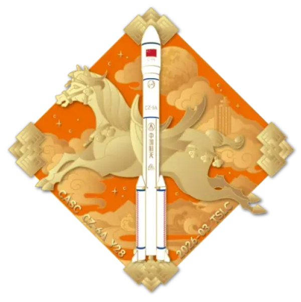
LM-6A Mission Patch (nasaspaceflight.com)
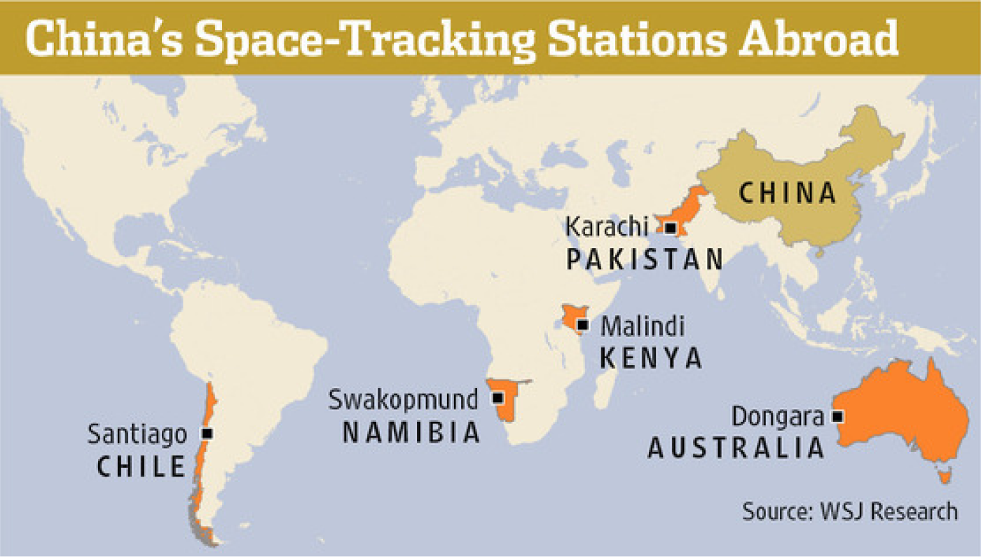
Map of Chinese Space Tracking Stations
(www.wsj.com)
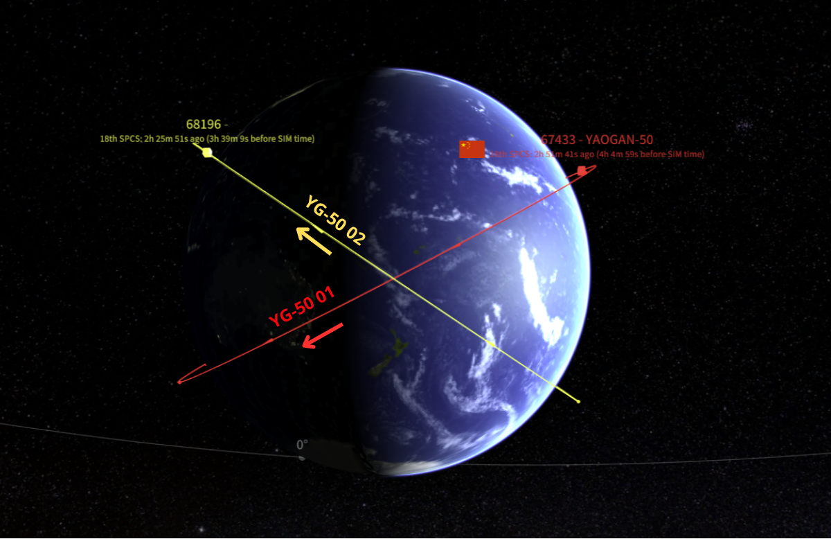
Both YG-50 01 & 02 are inclined 142°.
YG-50 02 has ~112° RAAN West RAAN Offset from YG-50 01
(saberastro.com)
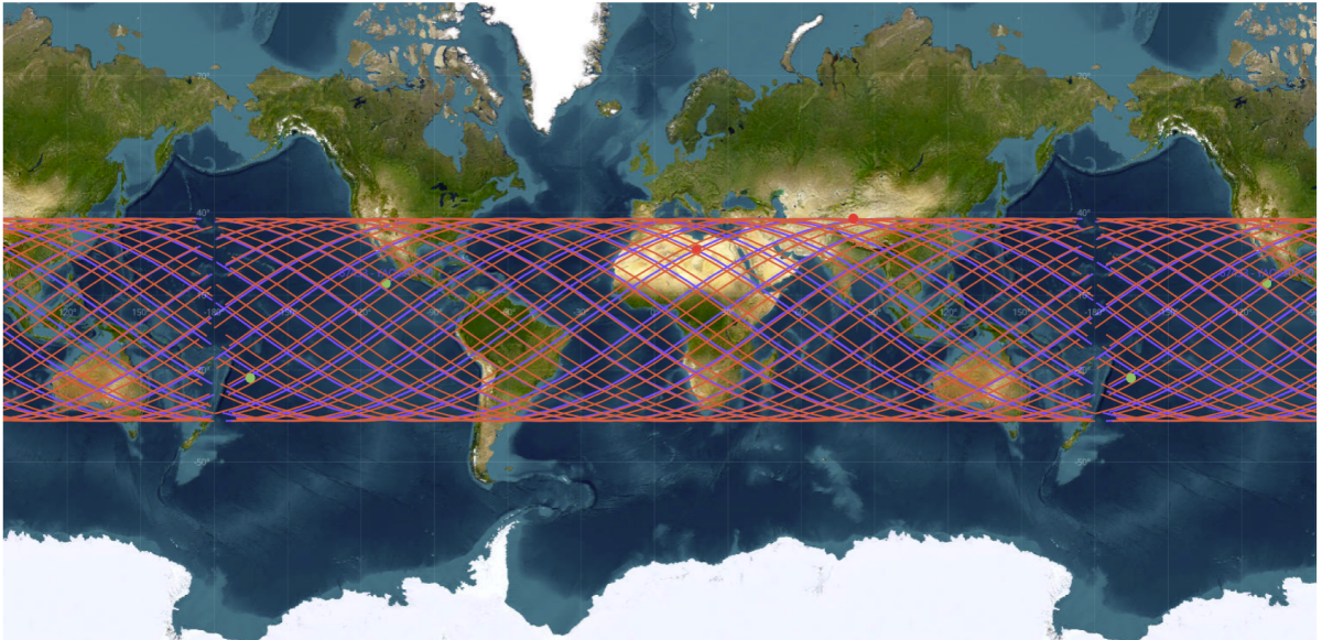
Ground Tracks of YG-50 01 & 02. With their 142° orbit inclination both satellites have coverage from 38°N to 38°S (saberastro.com)
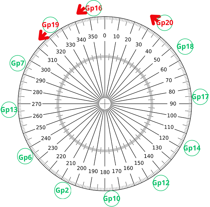
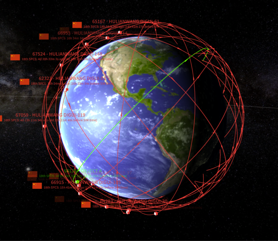
China Launches Guowang Group 20
12 Mar 2026: China launched a Long March-8A with the 20th group of Guowang (China SatNet LEO) satellites from the Hainan Commercial Space Launch Site, Wenchang International Aerospace City. According to official sources, the 9 satellites (68129-68137) entered the preset orbit successfully. As predicted in the 9 Feb 2026 Flash, Group 20’s orbital plane is east of Group 16 and west of Group 18. As of 16 Mar, 17 of 20 Guowang groups had reached their operational altitudes. Unlike the Qianfan constellation, all Guowang satellites have thus far reached their desired SMA. China now has 12x 50.0° orbital planes, each planes separated by 30° of RAAN. All Guowang launches to 50.0° inclination have been from Wenchang using either the LM-8A or LM-12. All of the 86.5° orbits originated either from Taiyuan using the LM-6A or Wenchang using the LM-5. We will need to wait to see if China focuses its launch capacity on completing its 86.5° orbital planes, adding density to its 50.0° planes (currently 9 satellites per plane), or adds new 50.0° planes (reducing 30.0° RAAN separation). I suspect we won’t have long to wait! Launch Video.
– With Group 20 there are now 163 satellites in the operational LEO Guowang constellation (see graphics & tables). Additionally, there are 3 Guowang satellites in GEO and China has launched 18 Guowang test satellites.
– China is building out the Guowang constellation with orbits inclined either 50.0° or 86.5°. Currently there are 108 satellites in 12x 50.0° orbital planes (9 satellites/plane) and 55 satellites in 6x 86.5° orbital planes (10 satellites/plane with one exception).
– Launch Summary + number of days to target SMA…1,167.9km for 86.5° or 1,149.3km for 50.0°
- Group 1 (16 Dec 2024): 10 sats on LM-5B. 86.5° inclination (110 days)
- Group 2 (11 Feb 2025): 9 sats on LM-8A. 50.0° inclination (77 days)
- Group 3 (28 Apr 2025): 10 sats on LM-5B. 86.5° inclination (34 days)
- Group 4 (5 Jun 2025): 5 sats on LM-6A. 86.5° inclination (with Gp 9) (106 days)
- Group 5 (27 Jul 2025): 5 sats on LM-6A. 86.5° inclination (with Gp 15) (58 days)
- Group 6 (30 Jul 2025): 9 sats on LM-8A. 50.0° inclination (103 days)
- Group 7 (4 Aug 2025): 9 sats on LM-12. 50.0° inclination. (117 days)
- Group 8 (13 Aug 2025): 10 sats on LM-5B. 86.5° inclination (32 days)
- Group 9 (17 Aug 2025): 5 sats on LM-6A. 86.5° inclination (with Gp 4) (52 days)
- Group 10 (25 Aug 2025): 9 sats on LM-8A. 50.0° inclination. (86 days)
- Group 11 (27 Sep 2025): 5 sats on LM-6A. 86.5° inclination. (54 days)
- Group 12 (16 Oct 2025): 9 sats on a LM-8A. 50.0° inclination (85 days)
- Group 13 (10 Nov 2025): 9 sats on a LM-12. 50.0° inclination (95 days)
- Group 14 (6 Dec 2025): 9 sats on a LM-8A. 50.0° inclination. (86 days)
- Group 15 (8 Dec 2025): 5 sats on a LM-6A. 86.5° inclination (with Gp 5) (58 days)
- Group 16 (11 Dec 2025): 9 sats on a LM-12. 50.0° inclination. (TBD)
- Group 17 (25 Dec 2025): 9 sats on LM-8A. 50.0° inclination. (74 days)
- Group 18 (13 Jan 2026): 9 sats on LM-8A. 50.0° inclination (63 days)
- Group 19 (19 Jan 2026): 9 sats on LM-12. 50.0° inclination (TBD)
- Group 20 (12 Mar 2026): 9 sats on LM-8A 50.0° inclination (TBD)
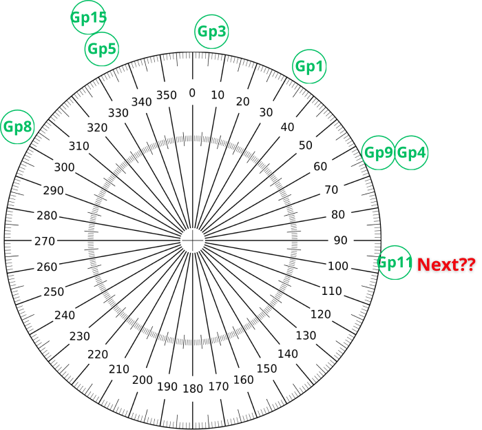
6x 86.5° Inclined Planes
10x Satellites / Plane (Gp 11 only 5 sats)
30° Offset for Satellites at Operational SMA
(saberastro.com)
16 Mar 2026: 12x 50° Inclined Planes 9 Satellites / Plane 30° Offset for Satellites at Operational SMA Red Groups Not at Final SMA (saberastro.com)
Current Guowang LEO Constellation (Gp20 in Green)(saberastro.com)
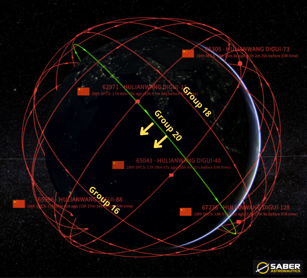
Group 20 Orbit Plane West of Group 18 and East of Group 16. Due to Group 20’s lower SMA its RAAN will shift west at a faster rate than Groups 16 & 18. China will time SMA increases to result in Group 20 being centered between Groups 16 & 18.
(saberastro.com)
13 Mar 2026: China launched a Long March-2D carrying the Shiyan-30 03-04 satellites (68139 & 68140) from Xichang. The launch comes 6 months after the China launched SY-30 01-02 (65851 & 65852) on 29 Sep 2025. According to official sources, the satellites entered their preset orbits successfully and will be used for “Earth observation technological testing and validation.” China released a similar mission description for SY-30 01/02. Launch Video.
– SY-30 03/04 are in similar orbits as their 01/02 predecessors. 03/04 have both executed orbit raising maneuvers and are currently at 592km average altitude with an inclination of 35°.
– SY-30 03/04 are co-planar with one another, however they are not co-planar with SY-30 01/02. SY-30 03/04 have a 5.5° east RAAN offset with 01/02. (see graphic).
-03/04 are separated by ~500km (in-track) with 03 in the lead position. This separation also matches that of 01/02, where 02 also leads 01 by ~500km.
-The matching orbital parameters and formations strongly suggests the satellite pairs are performing similar tests.
– 35° is a popular inclination for Chinese reconnaissance satellites. The following Yaogan constellations are also at this inclination (SMA values are from satellite initial deployment & do not represent current values)
- YG-30: 30 satellites, SMA = 600km
- YG-35: 15 satellites, SMA = 500km
- YG-36: 15 satellites, SMA = 500km
- YG-39: 15 satellites, SMA = 500km
- YG-42: 2 satellites, SMA = 500km
- YG-43: 18 satellites, SMA = 500km
– The initial orbits for SY-30 01/02 most closely match those of the YG-30 constellation.
- YG-30 are believed to be SIGINT satellites. China launched them in triplets from 2017-2021.
- YG-30 constellation consists of 10 sets of triplets in 6 orbital planes. We did an article on YG-30 in the 13 Oct 2025 Flash.
Editor’s Comment: The SY-30 satellites are not co-planar with any of the previously mentioned Yaogan satellites. China typically uses their Shiyan satellites to experiment with new technologies. SY-30’s similar orbit with the YG-30 satellites may indicate a potential follow-on radio frequency/geolocation (SIGINT) mission. However, this could also be purely coincidental. Comparing imagery of the two spacecraft types would provide further evidence.

Horses vs Dragons! SY-30 03/04 (top) vs
SY-30 01/02 Badges (below) (nasaspaceflight.com)
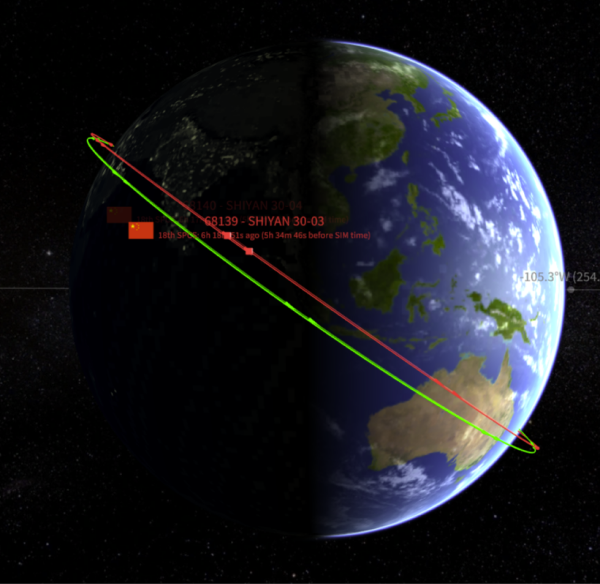
Orbit Visualization for
SY-30-03/04 (red) and SY-30 01/02 (green)
(saberastro.com)

SY-30 Satellite Pairs Are in Similar Orbits with Similar Spacing (saberastro.com)
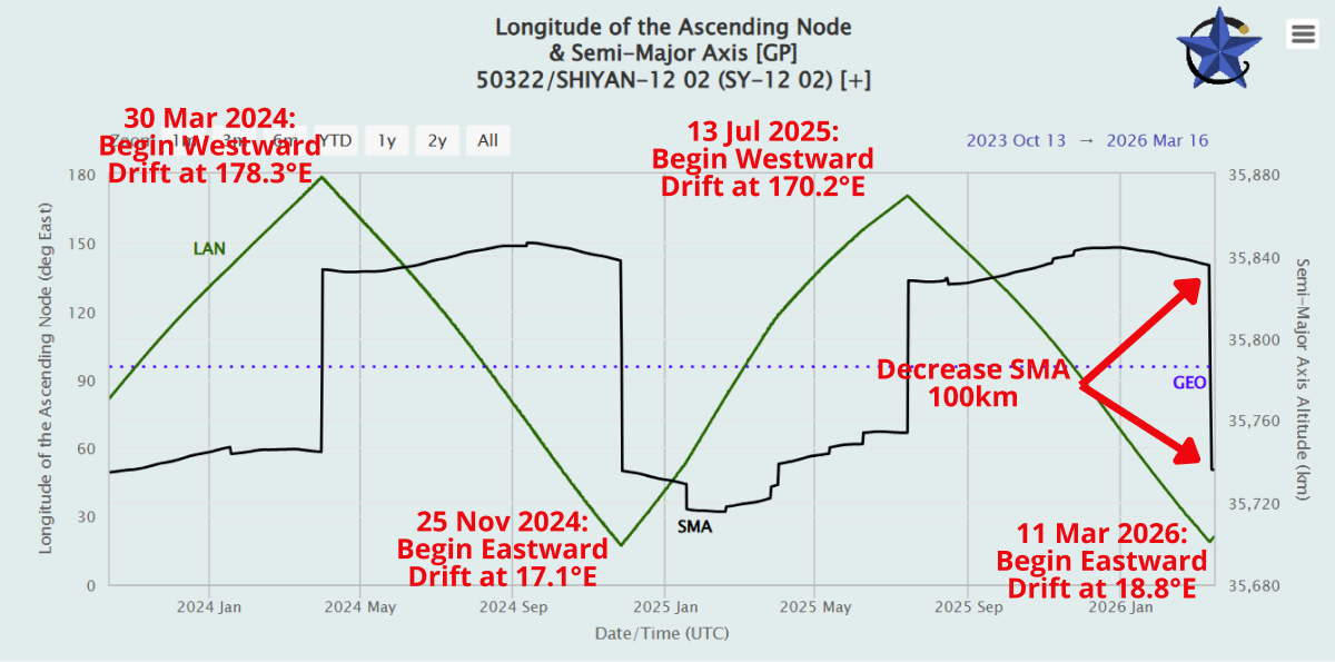
China: Shiyan-12 02 Reverses Course
17 Mar 2026: As predicted in the 19 Jan Flash, China decreased the average altitude of its SY-12 02 (50322) inspector satellite ~100km. As a result the satellite changed from drifting west 0.6° per day and is now drifting eastward 0.7° per day. China made the maneuver as SY-12 02 approached 18.8°E, previously China had allowed the satellite to move as far west as 17.3°E. If China maintains previous patterns, SY-12 02 will drift eastward for the next 8-9 months and reverse course when it arrives at ~175°E longitude. Average leg for SY-12 satellites is 244 days. Check out COMSPOC Video!
2 Yrs of SY-12 02 Orbital History: Average Altitude (black) and Longitude Location (Green) (celestrak.org)
– China launched the SY-12 01 and SY-12 02 satellites on 23 Dec 2021. This is SY-12 02’s 6th change of direction. SY-12 01 has also changed direction 6 times.
– SY-12 01 most recently changed directions on 13 Jan 2026 when it increased its average altitude to begin drifting Westward. SY-12 01 will likely reverse course in mid-September 2026.
– At current drift rates the two satellites will cross paths on 5 Jun 2026 at ~77.5°E.
– On average the two SY-12 satellites cover from 18.0°E to 175.1°E during each leg of their journey. Average time for each leg has been 244 days.
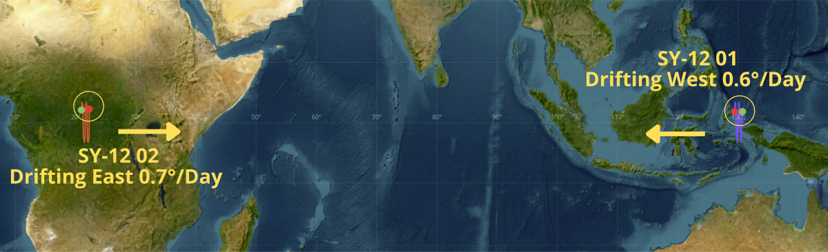
17 Mar 2026: Position and Drift Rates for SY-12 01 and SY-12 02 (saberastro.com)
Out of Formation: YG-31A/B/C Stumbles
18 Mar 2026: The Yaogan-31 A/B/C (43275, 43276, 43277) triplet has fallen out of formation. China launched the trio on 24 Feb 2021 and soon thereafter the satellites maneuvered into their isosceles triangle formation to conduct their RF detection/Geolocation (ELINT) mission. In June 2025 the satellites were maintaining this formation, however over the next 2 months this began to slowly change. YG-31C has a west RAAN offset with A & B and is normally equal distance between the two (see graphic). Between 10-15 Aug 2025 31C’s position relative to A & B began to change with C slowly falling behind the other two satellites. By 20 Sep 2025 31C had fallen completely behind 31B. China has not reversed the pattern and the satellites continue to slowly increase their distances from one another & likely not able to perform their mission. Reviewing the orbital history for all three satellites, there is no obvious failure and all remain at the same SMA (1,089.0km). It appears China has stopped maintaining the formation for unknown reasons.
YG-34 04 (56157), the imagery satellite trailing YG-31A/B/C is also no longer maintaining its relative position. All three of the other YG-31 formations remain intact.
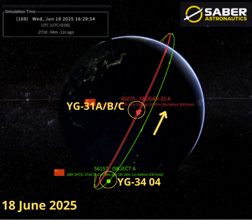
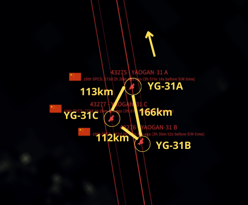
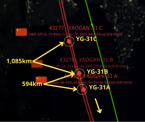
YG-31A/B/C Formation Comparison: 18 Jun 2025 Nominal Condition (left)
18 Mar 2026 Off-Nominal (right) (saberastro.com)
12 Mar 2026: China’s National People’s Congress officially adopted the 15th Five-Year Plan for Economic and Social Development (15th FYP). The document is intended to guide China’s social and economic development strategy from 2026 to 2030. While the final version of the document has not yet been released, the extensive draft outline provides a comprehensive overview of the country’s policy priorities and growth agenda up until the year 2030. Thankfully, Andrew Jones of SpaceNews reviewed the document for space-related implications.

– Excerpts from Andrew’s Article below, read entire piece Here.
- “China has designated aerospace to be an ‘emerging pillar industry’”
- “The report says China will ‘foster emerging pillar industries such as integrated circuits, aviation and aerospace, biomedicine and the low-altitude economy,’ placing aerospace alongside sectors considered central to the country’s long-term technological and industrial development.”
- “The move suggests Beijing intends to expand the space sector beyond strategic stateprograms toward a larger industrial ecosystem
encompassing launch services, satellites and downstream data applications.”
- “The move suggests Beijing intends to expand the space sector beyond strategic state programs toward a larger industrial ecosystem encompassing launch services, satellites and downstream data applications.”
- “This move appears to align with the recent emergence of the concept of “space+” in China, which envisions space treated less as a separate, standalone sector, and more as an enabling infrastructure to be integrated with other economic and strategic domains and national priorities.”
- The Five-Year plan contains “A column on frontier technology breakthroughs, including the areas of AI, quantum science and biotechnology, includes a segment on China’s deep space ambitions. The passage identifies implementing a second phase of planetary exploration projects, near-earth asteroid defense projects and solar system edge exploration projects.”
- “The section on deep space also notes objectives to develop reusable heavy-lift launch vehicles. This could refer to the Long March 10 series and larger Long March 9. The text also notes the construction of an international lunar research station (ILRS) and ‘implementation of lunar exploration projects.’”
- “China will also comprehensively advance satellite internet, according to the draft, including the launch segment and satellite constellations. Plans include constructing what is termed an integrated sky-Earth-ground, communication-navigation-sensing-computing fused comprehensive service system.”
- “It will also expand applications and internationalization of the Beidou navigation system, with the first new-generation Beidou satellites to launch around 2027.”
- “A space white paper, published by the China National Space Administration (CNSA), typically follows later in the year after the approval of a new Five-year plan, which will provide a more detailed outline of China’s plans to the end of the decade and beyond.”
Russian Intelligence Support to Iran
By Dr. Larissa Beavers
18 March 2026: The Wall Street Journal’s, Thomas Grove, recently reported that Russia is allegedly expanding military cooperation with Iran by providing satellite imagery, intelligence, and enhanced drone technology to support Iranian targeting of U.S. forces in the Middle East. These capabilities may include real-time or near-real-time geospatial intelligence, improved drone components, and operational tactics derived from the conflict in Ukraine. While Moscow has denied the claims, U.S. officials and reporting suggest this support could significantly enhance Iran’s situational awareness and strike precision against regional targets. The development reflects a deepening Russia-Iran strategic partnership and represents a notable escalation in indirect competition with the United States
Summary of Intelligence-sharing to Space Operations:
- Increased reliance on space-based ISR: Satellite imagery sharing highlights the critical role of space assets in enabling precision targeting of ground and maritime forces.
- Enhanced targeting accuracy through space-enabled data fusion: Integration of satellite imagery with drone systems improves Iran’s ability to conduct coordinated, multi-domain strikes against U.S. assets.
- Acceleration of space-enabled kill chains: Near-real-time geospatial intelligence shortens sensor-to-shooter timelines, increasing operational tempo and reducing warning time for U.S. forces.
- The transfer of satellite-derived intelligence and the integration of drones demonstrate how space capabilities are diffusing among regional actors, complicating efforts to achieve space superiority.
- U.S. reliance on space for navigation, targeting, and communications creates vulnerabilities when adversaries gain access to comparable ISR data.
- Blurring of the cyber, space, and EW domains: Drone improvements suggest integration with electronic warfare and potentially GNSS-dependent systems.
- This cooperation reinforces a model in which major powers leverage space capabilities indirectly through partners, thereby increasing competition below the threshold of direct conflict.

Russia’s Support to Iran Impact to Space Operations AI Generated Image
BeiDou on the Battlefield: Iran’s Use of China’s BeiDou
By Dr. Larissa Beavers
11 March 2026: Al Jazeera reporter Nina Montagu-Smith examines growing intelligence assessments that Iran may be leveraging China’s BeiDou satellite navigation system to improve the precision of its missile and drone strikes against U.S. and Israeli targets. Analysts point to noticeably increased strike accuracy in recent conflicts as a key indicator of external technological support, though neither Iran nor China has officially confirmed this cooperation. The potential use of BeiDou reflects broader geopolitical alignment between China and Iran and signals a shift away from reliance on Western-controlled space infrastructure. Overall, the development highlights how space-based navigation systems are becoming central to modern warfare and strategic competition.
Summary of Nina Montagu-Smith’s “Could Iran be Using China’s Highly Accurate BeiDou Navigation System”
- BeiDou, China’s alternative to GPS, offers high-precision positioning and resilience against jamming, making it attractive for military applications.
- In 2015, Iran reportedly signed an agreement to integrate BeiDou-2 into its military systems to enhance missile guidance accuracy beyond civilian PNT capabilities, but did not move to BeiDou until 2025.
- Iran’s Ministry of Information and Communications Technology stated that Iran uses “all existing capacities in the world and does not rely on a single source of technology.”
- Intelligence analysts link Iran’s increased strike precision to possible access to BeiDou’s high-accuracy positioning signals.
- Iran’s suspected use of BeiDou demonstrates how GNSS systems directly enable precision strike capabilities for missiles and drones.
- The development reflects deepening China–Iran technological cooperation, especially in military and dual-use systems.
- Expanded reliance on non-GPS constellations such as BeiDou contributes to a more contested and competitive space domain, in which multiple PNT providers enable adversaries to maintain operational capability even if a single system is degraded.


Pics o’ the Fortnight!

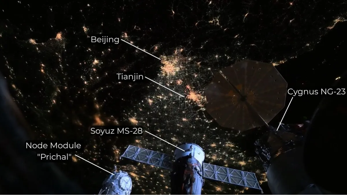
Beijing and Tianjin city spied between the solar panels of spacecraft docked aboard the ISS. (Image credit: NASA, Chris Williams, annotations by Anthony Wood) (space.com)

“Beijing time today 22:46, the spring equinox in the Northern Hemisphere in 2026, with the sun directly shining on the Earth’s equator. The image is from the Fengyun-4B satellite, located in geostationary orbit at 105° East longitude”
(@SegerYU via X)