Analysis of Developments in the Space Domain
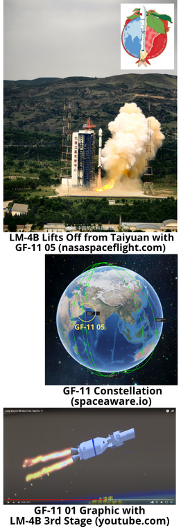
19 Jul: China launched a Long March-4B with the Gaofen-11 05 high resolution earth observation satellite from the Taiyuan Launch Site. According to official sources, Gaofen-11 05 entered the planned orbit successfully and will form a network with Gaofen-11 01, 02, 03 and 04, that “will be used in a variety of fields including land surveys, urban planning, road network design, crop yield estimation and disaster relief”. Previously, Chinese officials have stated that of the 14 Gaofen satellites variants “1-7 are civilian satellites, and 8-14 are military satellites.” The same official also noted “The best satellite in the U.S. is Keyhole. Its resolution is 0.1m. Our Gaofen 11 can also meet this standard.” Open source reporting notes the Gaofen-11 is also known by a military designation, the JinaBing-16. Launch Video.
– China launched GF-11 05 into a sun synchronous orbit. Currently it has a 693km apogee and 242km perigee and inclined 97.5°. This is typical for the initial GF-11 orbit, the satellite will likely circularize its orbit in the coming months and end up in a ~495x486km orbit similar to the other GF-11 spacecraft.
– All 5 of the GF-11 satellites have launched from Taiyuan and used the LM-4B.
– The first launch in 2018 included a video of the launch which showed a graphic rendering of the satellite attached to the third stage. This graphic suggests a 1.5-1.7m mirror on the satellite. With such a mirror the satellite would be capable of 0.15-0.2m resolution from its expected operating altitude of ~490km.
– Per Andrew Jones of SpaceNews:
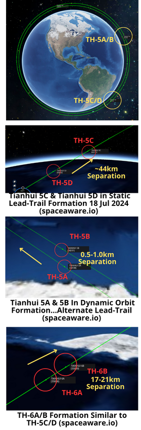
4 Jul: China launched a Long March-6A with the second TianHui-5 mission from the Taiyuan Satellite Launch Center. According to official sources, the two TianHui-5 02 satellites entered the planned orbits and “will be used for geographic mapping, land resource surveys, scientific experiments and other purposes”. There were reports of first stage boosters landing in populated areas as well as a upper stage breakup and debris
generating event. Way to go China. Launch Video.
– China launched Tianhui 5C & 5D (TH-5C/D) into a co-planar orbit with TH-5A/B which China launched on 31 Oct 2023 (also using a LM-6A from Taiyuan). TH-5C/D are also nearly co-planar with TH-6A/B launched in March 2023 on a LM-4C from Taiyuan.
– Tianhui 5C & 5D are in a 603 x 602km orbit and are both inclined 97.8°. This matches the TH-5A/B pair. TH-6A/B are in an 888× 880 km orbit with an inclination of 99°.
– Open source reporting notes that the satellites “are operated by the People’s Liberation Army (PLA).”
-Per Orbital Focus, the TH-5 and TH-6 “satellites will probably work together to produce 3D radar imaging.”
– While 5C & 5D are co-planar with 5A & 5B they currently are not orbiting in the same formation. The 5C/5D pair remains consistent with 5C in lead and 5D in trail position. The satellites are separated by ~44km. This is similar to the TH-6A/B pair which has 6A in lead and 6B in trail separated by ~17-21km.
– In contrast, TH-5A/B operate much closer with a separation varying between ~0.5 to 1.0km with the satellites alternating lead and trail positions. It remains to be seen if TH-5C/D modify their orbits to match the 5A/5B pair in the coming months.
– For historical context, the Tianhui-2 satellites were China’s first microwave surveying satellite system based on synthetic aperture radar (SAR) technology. TH-2 satellites operate in the X-band, with a 3m resolution. In May 2023, China maneuvered Tianhui 2-02A & 02B to within 1 km of one another.
– The LM-6A upper stage may have had a debris generating event on orbit. According to s2a systems: “on 5 July…the upper stage produces a lot of visually detectable debris.”
– Per Andrew Jones article: “U.S. Space Force’s space domain awareness has not cataloged any debris associated with the upper stage, suggesting the objects are very small.”
– S2a also noted significant debris (60 pieces) after the TH-6A/B launch in March 2023.
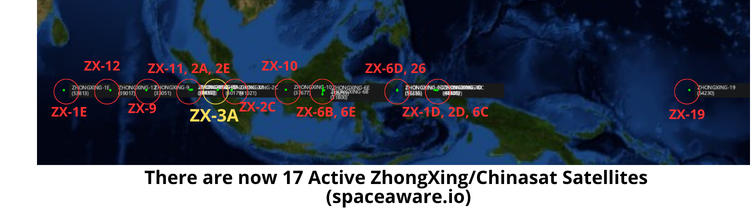
8 Jul: About 1 week after launching ZhongXing-3A (Chinasat-3A) on a Long March-7A the satellite has settled into its GEO slot at 101.6°E. Per Chinese government press releases, ChinaSat-3A will “provide voice, data, radio and television transmission services”.
– China released very limited information regarding Chinasat-3A. The satellite will join 16 other ZhongXing (Shentong or Chinasat) satellites in GEO in the coming days.
-Chinasat-3A is currently located to the east of a cluster of Chinsat-2A/2E/11 satellites and to the west of Chinasat-2C.
-China is in the process of replacing its older satellites. In Nov 2023 it launched Chinasat-6E to augment/replace Chinasat-6B which was launched in 2007.
-Chinasat-3A was not mentioned previously. The next expected launch was Chinasat-9C to replace Chinasat-9 sometime in 2025.
-The original Chinasat-3 was launched in 1990 and is listed as “Dead” in the spacetrack.org catalog.
-Assuming Chinasat-6E has replaced Chinasat-6B and Chinasat-9 will be replaced by Chinasat-9C in 2025, the next likely candidates for augmentation/replacement are Chinasat-10 (2011), Chinasat-2A (2012) and Chinasat-12 (2012).
-Chinasat satellites have a life expectancy of 15 years.
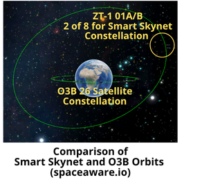
16 Jul: After China launched two Smart Skynet-1 satellites (59705 and 59706) to Medium Earth Orbit (MEO) on 9 May 2024 both satellites are now cataloged. Smart Skynet has a different inclination and SMA than the “Other 3 Billion” (O3B) MEO constellation owned and operated by SES.
– Smart SkyNet-1 01 (A/B) (aka Zhihui Tianwang-1 01A/B or ZT-1 01A/B) 59705/59706 are the first 2 of 8 planned satellites for the constellation.
– Locating and identifying these satellites appears to have been challenging for space observation networks. ZT-1 01A (59705) was not identified until 31 May, 22 days after launch and ZT-1 01B (59706) was not located until 5 Jun, 27 days after launch.
-The two satellites are co-planar, with an altitude of 20,199×20,165km and inclination of 53.1°. They are in lead-trail configuration with ZT-1 01A in lead position, consistently ~1,350km ahead of ZT-1 01B. The orbital period for both satellites is 11hrs 57min.
-By comparison the O3B constellation is made up of 26 co-planar satellites operating at a much lower altitude, 8,077x 8,060km and 0° inclination.
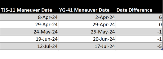
20 Jul: China appears to be coordinating the station keeping maneuvers of Yaogan-41 and TJS-11. Looking at the maneuver history of both satellites shows a pattern of station keeping maneuvers not seen with other Chinese satellites.
– In their first 5 months on orbit the satellites have maneuvered every 3-4 weeks with YG-41 maneuvering after TJS-11. (see table below)
– China launched Yaogan-41 on 15 Dec 2023 and it is believed to be an imagery satellite capable of 5m resolution.
– China launched TJS-11 on 23 Feb 2024 and its mission is unknown. Other TJS missions have been associated with missile warning, signals intelligence, and satellite inspection.
– China used its largest rocket, the LM-5B, equipped with an extended fairing for both launches.
– China positioned TJS-11 between Gaofen-13-01(2.4° separation) and YG-41 (3° separation). Gaofen-13-01 is also a GEO-based imagery satellite.
– At 5.5° inclination TJS-11’s orbit is the most inclined of any of the TJS satellite family. YG-41’s orbit is also more inclined than China’s other electro-optical GEO based imagers and is 0.7° less than that of TJS-11.
– TJS-11 arrived in GEO 70 days after YG-41, and the two orbits appeared to track closely with one another from the start, with TJS-11 slightly trailing YG-41 as they completed their “figure 8” orbital pattern.
– YG-41 reaches its northernmost point of its orbit ~60-90 minutes prior to TJS-11 reaching its northernmost point.
The first few months of operation appears to demonstrate that the maneuvers of the two satellites are coordinated.
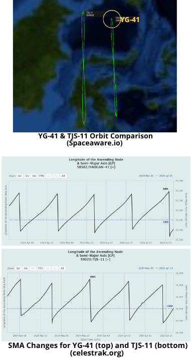
18 Jul: China’s experimental SJ-23 satellite conducted a “fly by” operation in which it came within 60km of Es’hail-1, a Qatari communications satellite. The maneuver appears to have been timed to provide SJ-23 with optimal lighting conditions (solar phase angle/SPA) for potentially imaging Es’hail-1. Launched on 8 Jan 2023, SJ-23 has an interesting history with examples of close approaches with other satellites.
– Based on orbital data from Celestrak, SJ-23 (55131) decreased its altitude 101.4km from 12-15 July. The maneuver reversed its drift from 0.65°/day West to 0.65°/day East.
– On 18 Jul ~20:24Z SJ-23 had its point of closest approach with Es’hail-1 (39233) of just under 60km. At this time the solar phase angle between SJ-23 and Es’hail-1 was ~155° which is favorable for SJ-23 to image Es’hail-1.
–Es’hail-1 is also known as Eutelsat
25B. It is an older satellite, launched in
2013 and has 32 Ku- and 14 Ka-band
transponders.
SJ-23 History
– China launched SJ-23 on 8 Jan 2023 on a LM-7A. Shortly after arriving in GEO it released a small object (55180). It was initially believed SJ-23 likely a follow-on to SJ-13, a communications satellite. However, the release of a sub-payload is more indicative of SJ-17, TJS-3 and SJ-21 which are believed to have a satellite inspection or potential counterspace missions.
-On 17 Mar 2023 ~04:54Z, SJ-23 had a <4km close approach with China’s Tianlian-1 03 relay satellite. At that time imaging conditions were favorable for SJ-23 with a SPA of 114°. Video.
– On 5 May 2023 SJ-23 had a point of
closest approach of ~116km with the European data relay satellite, EDRS-C satellite (44475). During the POCA solar phase angle was 62° and not conducive to SJ-23 imaging EDRS-C.
– On 5 Dec 2023 SJ-23 had a ~83km close approach with another Chinese data relay satellite, Tianlian-2 02. During the time of closest approach, solar phase angle was 150° and favorable for SJ-23 to image TL-2 02. Watch Video.
Editor’s Note: All maneuver and solar phase angle analysis for this article is based off TLE data which contains inaccuracies and may not account for all maneuvers. For example, LSAS analysis of the SJ-23 – TL-2 02 interaction in Dec 2023 indicated the two satellites had 2 close range encounters (25km & 40km). Contrast this with what I was able to find using TLE data which was a single encounter at a range of 83km. Definitive results require additional research and use of ephemeris data.
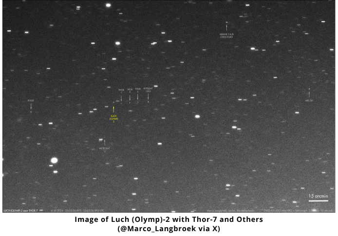
20 Jul: On 22 June, Russia maneuvered its suspected SIGINT satellite, Luch (Olymp)-2 (55841), west after spending ~88 days in vicinity of Astra 4A. On 1 July Luch (Olymp)-2 arrived in vicinity of Norway’s Thor-7 (40613) at 0.6°W longitude. Luch (Olymp)-2 continues to operate near Thor-7 with some reporting of the two satellites getting as close as 5km from one another.
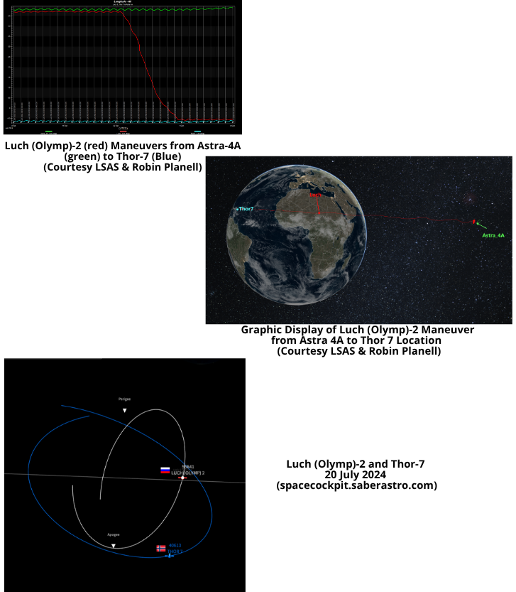
20 Jul: On 22 June, Russia maneuvered its suspected SIGINT satellite, Luch (Olymp)-2 (55841), west after spending ~88 days in vicinity of Astra 4A. On 1 July Luch (Olymp)-2 arrived in vicinity of Norway’s Thor-7 (40613) at 0.6°W longitude. Luch (Olymp)-2 continues to operate near Thor-7 with some reporting of the two satellites getting as close as 5km from one another.
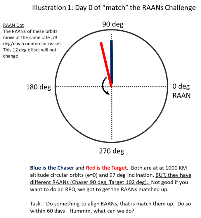
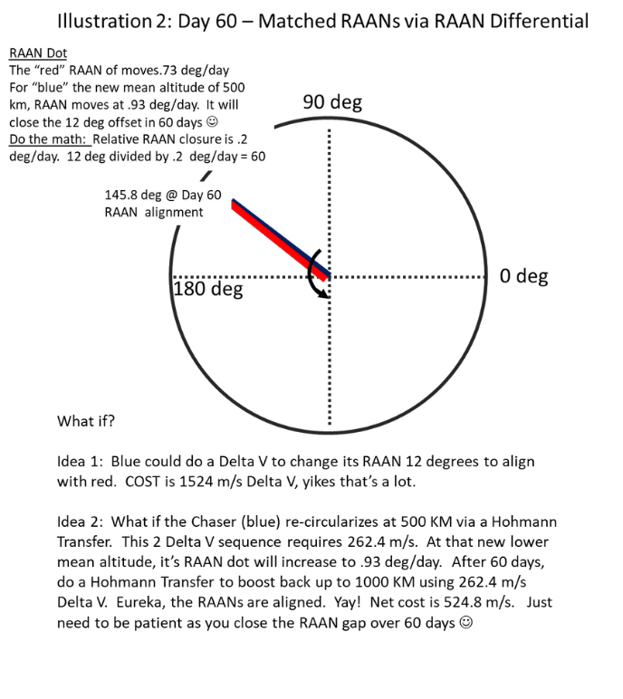
The 100th issue of the Final Frontier Flash has a very interesting article entitled “YG-35 01 Formation Falls Apart.” It discusses the astrodynamics of why the “break up” occurred. Back in the 19 Nov 2023 issue there was an article about “Yaogan-40-01 now in formation” and in that article there’s a statement “The effect of having satellites orbit at two slightly different orbit heights is that the two orbit planes move at different rates, with the lower orbit moving faster.” I thought I’d do an example astro situation with a Chaser (which in my illustration will be the blue satellite) and the target, which I made red.
Let me set up the problem then you can see my two illustrations to help you see and understand RAAN-dot differential, at least that’s what I call it. Both satellites are matched up in all but RAAN. The red Target has a RAAN of 102 deg and the blue Chaser is at 90 degrees. Both satellites are at circular 1000 KM, and 97 deg inclined. The RAANs will move .73 deg/day in a counterclockwise direction. That rate is a function of Mean Altitude and Inclination, there is a little effect due to Eccentricity, but that’s zero since these are circular. So the problem is how do we align the Chaser’s RAAN with the Target? In my illustrations there is a set up and I depict RAAN in a Polar Plot. You can see they are separated by 12 degrees and will stay that way. I introduce two opens, study the illustrations and bolster your awesome astrodynamic know-how!