Analysis of Developments in the Space Domain
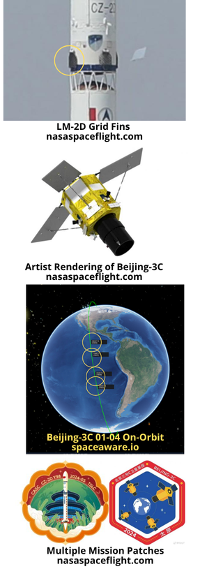
20 May: China launched a Long March-2D with four Beijing-3C satellites (BJ-3C) from Taiyuan. The Beijing-3C constellation includes four optical remote sensing satellites that can “achieve 0.5m resolution color and 2m multispectral at an orbital altitude of 500km”. According to official sources, the satellites entered the predetermined orbits. Interestingly, China equipped the LM-2D with grid fins to better control the “landing” of the rocket’s first stage. Launch Video. Watch video of Grid Fins in action.
– All four satellites (Beijing-3C 01-04) are in sun synchronous orbit (SSO) with an altitude of 498x485km and an inclination of 97.5°.
– A Chinese private company, Twenty First Century Aerospace Technology Co. Ltd. (21AT) will operate the satellites.
– On 24 May, China Aerospace Science and Technology (CAST) Corporation reported it had successfully received its first image from Beijing-3C.
– Beijing-3C 04 is also known as The “Zhengzhou Airport” satellite. One Chinese press reported this satellite is equipped with Century Space’s onboard intelligent monitoring and on-orbit processing technology. Together with the ground measurement and control receiving station network, Internet cloud service center, user application terminals, etc., it forms an integrated “satellite-ground-cloud-end” system that can achieve rapid coverage of large areas, has on-orbit intelligent image processing and information interpretation and analysis capabilities, and supports on-orbit extended processing functions.
– This is the third launch of the Beijing series imagery satellites. China launched Beijing-3A and three other satellites in June 2021. All are reported “dead” in the spacetrack.org catalog. In 2022 China launched Beijing-3B and that satellite remains active and operating at a SSO with an orbit of 612.9×593.7km.
– This is not the first time China has experimented with using grid fins on the LM-2D. This was first tested on a 14 October 2021 launch also from Taiyuan. The launch carried the Chinese H-Alpha Solar Explorer and 10 other satellites into orbit.
– The purpose of these is not to help recover the stage for reuse, but to help guide it as it falls back to Earth and ensure that it falls harmlessly into its planned drop zone.
– Because China’s older launch sites are located inland, its rockets have become infamous for dropping debris in populated areas (see video1 or video2). China is using grid fins in attempt to reduce the risk to people and property under the flight path.
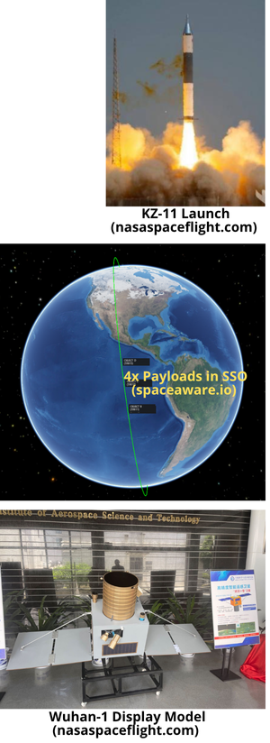
21 May: China launched a Kuaizhou-11 (KZ-11) solid-fuel rocket from Jiuquan. There were 4 satellites on board: 1) Wuhan-1 (primary payload); 2) Chutian-001 an “Ultra-low orbit technology experimental satellite”; 3) TianYan-22, and 4) LingQue-3-01. The satellites are all reported to have entered their planned orbits. This is the second successful launch of ExPace Technology Corporation’s KZ-11 which is a subsidiary of China Aerospace Science and Industry Corporation (CASIC). None of the satellites are currently operating in Very Low Earth Orbit (VLEO) which is defined as having an altitude <300km. Launch Video.
– All four satellites are currently in a ~534x522km orbit with a 97.6° inclination. To conduct VLEO testing Chutian-001 will need to lower its orbit.
-Wuhan-1 is “is an intelligent remote sensing satellite that integrates high-resolution, hyperspectral imaging, night-light imaging, stereo mapping and video imaging functions. It will conduct continuous observations of the Wuhan metropolitan area.”
-Chutian-001 is the test VLEO satellite. Per Chinese government announcements:

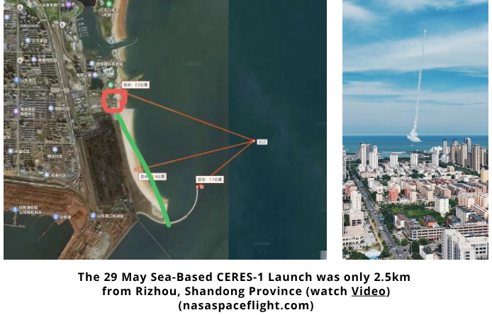
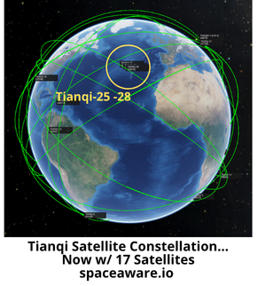
29 May: A Chinese commercial space company, Galactic Energy, launched a CERES-1S solid fuel rocket with four Tianqi satellites on board (Tianqi-25 ~ 28). The launch occurred from a ship located near Haiyang, Shandong Province. CERES-1 can carry a up to 350kg to Low Earth Orbit (LEO). Launch Video.
– All 4 of the Tianqi satellites were successfully placed into a 854x835km orbit with a 45° inclination. The satellites will likely increase their spacing in the coming weeks.
-The launch brings the total Tianqi constellation to 17 satellites. The satellites are in a variety of orbits and several appear to have not maneuvered in quite some time.
– The full Tianqi constellation will have 38 LEO satellites.
– “The Tianqi LEO satellite constellation is being built and operated by LEO satellite operator Guodian Gaoke (Guodian Gaokeji), a Chinese private commercial space company and leading provider of domestic satellite IoT.”
– Lu Qiang, chief executive of Guodian Gaoke, told Chinese media last year that the company plans to “expand our services to other fields, including outdoor emergency response and military applications.”
– This is the second sea-based launch for the CERES-1 rocket. The first occurred on 23 Sep 2023. That launch also also placed 4 Tianqi satellites (21-24) into LEO.
31 May: Galactic Energy set a record for Chinese commercial launch companies when it conducted its second launch in 3 days. A second Ceres-1 rocket lifted off from the Jiuquan Satellite Launch Center and carried five satellites into LEO: 1) Jiguang 01; 2) Jiguang 02; 3) Hebei Linxi-1; 4) Zhangjiang Gaoke; and 5) Nishuihan-2. Launch Video.
– All 5 satellites are in SSO with altitudes of 544x525km and a 97.6° inclination.
-The 2 Jiguang satellites will “carry out long-term communication verification between satellites and the ground in orbit, build an ’on-orbit laser communication experimental platform.’”
-Hebei Linxi-1, Zhangjiang Gaoke and Nishuihan-2 satellites (aka Yunyao-1 14, Yunyao-1 25 & Yunyao-1 26) are part of the Yunyao-1 meteorological constellation. All are meteorological remote sensing satellites equipped with GNSS occultation and long-wave infrared camera payloads.

– “Yunyao Aerospace plans to complete the launch of 41 satellites and build a global meteorological space monitoring constellation consisting of 90 satellites by 2025, forming a global high-resolution, high-precision, full-scale atmospheric detection system, breaking the foreign meteorological monopoly, and providing ‘Belt and Road’ countries with high-efficiency weather forecasts and short-term earthquake warning services, thereby enhancing international influence.”
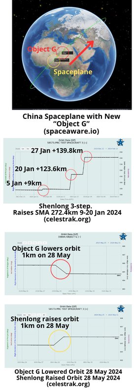
25 May 2024: The 18 Space Defense Squadron catalogued a new object released from the Chinese Spaceplane. “Object G” is the 7th object tracked near the Shenlong (Divine Dragon) re-usable spaceplane that launched on a Long March 2F from Jiuquan Launch Center on 14 Dec 2023. Object G appears to have reduced its altitude (semi-major axis) after deploying and is now orbiting ahead of the Shenlong (there’s that 10:1 rule in action again!).
– This is Shenlong’s third test flight. The first occurred in in 2020 and remained in orbit for just four days. Shenlong’s second mission stayed on orbit for 276 days (4 Aug 2022 – 8 May 2023.)
-There were reports of Shenlong releasing objects during its second mission. LEO Labs reported “Analyzing data from our global radar network, we’ve determined that the Test Spacecraft2 has propulsive capability and engaged in proximity operations with Object J, including what appeared to be at least two and possibly three capture/docking operations.”
– For its third, and current mission, China launched Shenlong into an initial orbit of 332.9 x 347.9 km with a 49.99° inclination. The spaceplane is now operating in a 609x603km orbit with the inclination remaining unchanged.
-Shortly after launched there was speculation Shenlong released up to six objects, and that some of these were transmitting radio signals.
-None of the six objects are in the current spacetrack.org catalog. There is the possibility that they were debris as others have noted the standard LM-2F launch typically generates six objects: payload, rocket stage and four fragments, with expected deviations in height/period and inclination – usually described as solid motor cover separation.
<editors note: in case anyone is interested…there is an amazing Tiktok video showing the retrieval and display of the 1st Shenlong Test Flight fairing.>
-Shenlong had a busy first 6 weeks on orbit. Chinese operators increased the spaceplane’s altitude over a period of 3 weeks (5 -27 Jan 2024). Shenlong initially increased its altitude 9km on ~5 Jan, then jumped another 123.6km on ~20 Jan and finally made a 139.8km increase on ~27 Jan to its present operating altitude.
-Object G and Shenlong both appear to have maneuvered on 28 May, with Object G lowering its SMA ~1km to 604.8km and Shenlong raising its orbit ~1km to 605.8km. With an SMA difference of 1km Object G is now moving ahead of Shenlong ~10km/orbit.
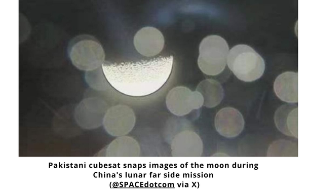
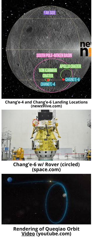
1 Jun 2024: For the second time, China has successfully landed one of its Chang’e spacecraft on the moon’s far side. Chang’e-6 landed in the southern portion of Apollo crater within the South Pole-Aitken (SPA) Basin at 0623 Beijing time. Chang’e-6 will attempt to collect samples from SPA and send them back to Earth. U.S. decadal surveys have highlighted a SPA sample return as a highest priority science objective. China used its newest moon relay satellite, Queqiao-2, to communicate with Chang’e-6 during landing. Watch Video. Watch Time-Lapse Footage of Landing.
– Chang’e-6 joins Chang’e-4 as the only manmade objects to successfully land on the lunar far side. Chang’e 4 made its landing in January 2019 in the moon’s Von Karman Crater and contained a lander-rover combo.
-Chang’e 6 launched on 3 May and arrived in lunar orbit ~7 May. Per space.com: “It spent the next few weeks scrutinizing its planned landing site and gearing up for today’s big event, which went according to plan: Chang’e 6’s lander came down softly in Apollo Crater, leaving the mission’s orbiter, with its attached Earth-reentry module, circling the moon.”
-More from space.com:
30 May 2024: China launched a Long March-3B from Xichang with the PakSat-MM1 communications satellite. PakSat-MM1 is based on the DFH-4E satellite bus and had a liftoff mass of 5,400kg. The satellite will provide communications services for Pakistan Space and Upper Atmosphere Research Commission (SUPARCO). It is equipped with 9 antennas and 48 transponders and operates in the C, Ku, Ka, and L bands. Launch Video.
– As of 1 June 2024, PakSat-MM1 remains in geosynchronous transfer orbit (GTO).
– Per the amazing Jonathan McDowell: “The original Paksat-MM1 operated from 2018 Feb to 2022 Jan at 38.2E; it was originally the Asiasat 4 satellite and was leased by Pakistan from Asiasat. The new Paksat-MM1, built by the China Academy of Space Tech., will be stationed at the same 38.2E location.”
– Per Andrew Jones: “Space ties between Pakistan and China have grown in recent times. Paksat MM1 is part of “2021-2030 Space Cooperation Outline Programs” between China and Pakistan and is financed by a concessional loan from the Chinese government…<Pakistan also> jointly-developed the Icube-Q small satellite that was recently released into lunar orbit by Chang’e-6, and Pakistan has committed to joining the China-led International Lunar Research Station (ILRS).”

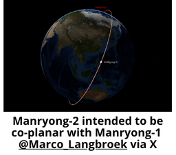
27 May 2024: North Korean news reported that country’s attempt to launch a second military reconnaissance satellite launch failed. North Korea attempted to launch “Manryong-1-1” (aka Manryong-2) on a new rocket from the Seosong Satellite Launch Site in Cholsan County, North Pyongan Province. The new satellite carrier rocket exploded in mid-air during the first stage of the flight. North Korean investigators’ preliminary assessment was that the unreliability of the newly developed liquid oxygen + petroleum activator may have caused of the accident. Launch Video.
– Per Dr Marco Langbroek: “The 13:44 UTC listed launch time of the failed North Korean Malligyong-2 launch attempt would, if it hadn’t failed, placed in in the same orbital plane as Malligyong-1.”
– After its first successful launch after 2 previous failures, North Koreas dictator, Kim Jung-Un announced plans to launch 3 additional satellites in 2024.
– Per the New York Times: “North Korea is barred by United Nations Security Council resolutions from launching long-range rockets because they use the same technology needed to build intercontinental ballistic missiles.”
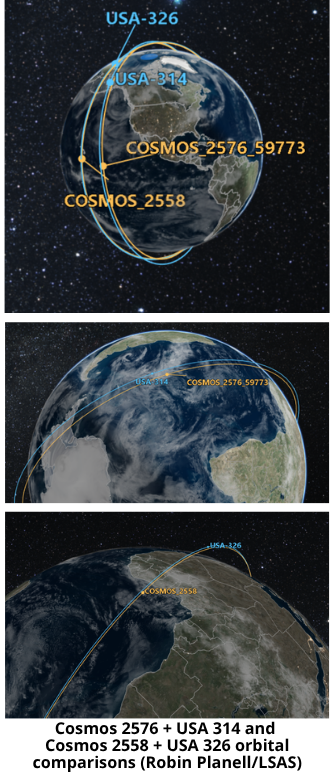
20 May 2024: During a Security Council meeting, US United Nations ambassador Robert Wood accused Russia of launching a ‘counterspace weapon’ into Low earth Orbit on May 16. Ambassador Wood was no doubt referring to Cosmos-2576. Pentagon spokesman Brigadier General Pat Ryder later repeated the claim. The Pentagon statement mentioned Cosmos-2576 was in “the same orbit” as a US Government satellite, in this case USA 314. This should sound familiar as it is the third time Russia has launched
one of its satellites to be nearly co-planar with a US
high-value asset.
– Here is the US Statement: “Just last week, on May 16, Russia launched a satellite into low Earth orbit that the United States assesses is likely a counterspace weapon, presumably capable of attacking other satellites in low Earth orbit…Russia deployed this new counterspace weapon into the same orbit as a U.S. government satellite.”
-As noted previously Russia launched Cosmos-2576 into a nearly co-planar orbit with USA 314.
<Editor’s Note: Orbital parameters for USA 314 are not published in spacetrack.org and all corroborating evidence is available only through other open-sources of information such as Orbital Focus. These single Two Line Element sets were used to create our graphics.>
-Per Dr Marco Longbroek’s SatTrackCam Leiden (b)log:
24 May: The New York Times published an article describing the progress Russia is making in regards to disrupting Ukrainian forces’ use of the Starlink network. The report details how Russia has deployed advanced tech resulting in more outages on the northern front battle line. More excerpts below.
– Starlink has been critical to the Ukrainian military since the earliest days of the war with Russia. Without the full service, Ukrainian soldiers couldn’t quickly communicate and share information about the surprise onslaught (Russian attack) and resorted to sending text messages.
-Just before Russian troops pushed across the Ukrainian northern border this month (May), members of Ukraine’s 92nd Assault Brigade lost a vital resource. Starlink satellite internet service.
– As Russian troops made gains this month near Kharkiv…they deployed stronger electronic weapons and more sophisticated tools to degrade Starlink service.
– The new outages appeared to be the first time the Russians have caused widespread disruptions of Starlink.
– Mykhailo Fedorov, Ukraine’s digital minister, said Russia’s recent attacks against Starlink appeared to use new and more advanced technology. The service previously held up remarkably well against interference on battlefields, where there has been widespread electronic warfare, radio jamming and other communication disruptions.
– The Russians are now “testing different mechanisms to disrupt the quality of Starlink connections because it’s so important for us,” Mr. Fedorov said, without giving details about what he called their “powerful” electronic weapons systems.
– “One day before the attacks, it just shut down,” said Ajax, who would be quoted only on the condition of being named by his call sign, in keeping with Ukrainian military policy. “It became super, super slow.”
– Several experts said Russia had gotten better at interfering with the signal between the satellites and Starlink terminals on the ground by using powerful and precise jammers. Others suggested that the service had been disrupted by specialized electronic weapons mounted on drones.
– In some instances, technical restrictions intended to keep Russian forces from using Starlink have hurt service for Ukrainian soldiers along the front line.