
October 14, 2026
The integrity flash
Analysis of Developments in the Space Domain
In This Issue
Russia: Cosmos 2589 Conducts RPO of Cosmos 2526
Russia: Cosmos 2612 – Climbing Out to Fall Back In
China: Kings on the Move – TJS-17 & TJS-19 Relocating
China Launches Guowang Group 27
Seven Sons: Beihang University
India’s New View from GEO: EOS-05 and the Next Phase of Indian Space Power
Cyber Series Part 3 - The Long Way to Orbit: Ground Systems as a Gateway to Space
Pics o’ the Fortnight!
Russia: Cosmos 2589 Conducts RPO of Cosmos 2526
9 Oct 2026: After an ~11-week, ~30° trek east from 98.0°E, Russia’s Cosmos 2589 (64467) appears to have found its next stop. From 25-30 September, Russian operators raised the satellite’s semi-major axis (SMA) ~94 km, halting its eastward drift and parking it at ~128.1°E. That is alongside Cosmos 2526 (43432), a Russian military communications satellite. Orbital data shows the RPO was set up by Cosmos 2589. Cosmos 2526 has done nothing but routine station-keeping.
How We Got Here
Readers will recall Russia launched Cosmos 2589 on an Angara-5/Briz-M from Plesetsk in June 2025 into a geosynchronous, highly elliptical orbit. It then released a sub-satellite, Cosmos 2590 (64527), which conducted RPOs against its parent through November 2025. From November 2025 through April 2026, Russia methodically circularized Cosmos 2589’s orbit, and the satellite parked at 98.0°E in early May (Issue 144). There it was watched by USA 325 (51281) and then USA 271 (41745) (Issues 148 and 150).
On 20–24 July Russia lowered Cosmos 2589’s SMA ~33 km and the satellite began drifting east ~0.4°/day (Issue 150). In Issue 154 we reported a second lowering of ~71 km on 18–23 September, which accelerated the drift to ~1.2°/day. We also reported two burns on 24–25 September that slowed the satellite ~36 hours before a predicted close approach with USA 270 near 126°E. Those burns increased the point of closest approach (POCA) with USA 270 from 26.7–41.4 km to 112.3 km. At the time I wasn’t sure where (if?) Russia would stop. We now know: those burns were the start of a braking sequence that carried Cosmos 2589 ~2° past USA 270 to Cosmos 2526.
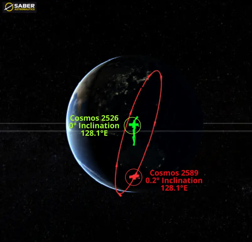
9 Oct 2026: Cosmos 2589 Maneuvered into RPO Condition with Cosmos 2526. Current Proximity Ranges from ~30-175km (saberastro.com)
Meet Cosmos 2526
Cosmos 2526 is Blagovest No. 12L. Russia launched it on a Proton-M/Briz-M from Baikonur in April 2018. Blagovest satellites provide C- and Ka-band communications (internet, telephony, video and broadcasting) for Russian military and government users, with a 15-year design life. Cosmos 2526 is a well-behaved GEO satellite. It holds its slot at ~128.1°E with frequent small east/west maneuvers (SMA within ~2 km of GEO). It also actively maintains its inclination near 0.02–0.03°, which tells us it is still operational.
Note that ISS Reshetnev built both satellites and both use the “heavy (and rarely used) Express-2000 platform” (thank you Bart Hendrickx). Until now, Cosmos 2589’s only documented close-proximity partner was its own sub-satellite, Cosmos 2590.
Maneuver Summary: Cosmos 2589 Did the Work
- 20–24 Jul: SMA −33 km. Departs 98.0°E at ~0.4°/day east.
- 18–23 Sep: SMA −71 km in daily burns, to ~94 km below GEO. Drift increases to ~1.2°/day east. The burns also pumped eccentricity from 0.0001 to 0.0017.
- 25–30 Sep: SMA +94 km in at least four burns: ~15.6 km/day on 25, 26 and 27 Sep, then ~47 km between 27 and 30 Sep. Drift goes to near zero at ~128°E, and eccentricity is trimmed back to ~0.0007.
- 1–9 Oct: No further maneuvers. Cosmos 2589 sits ~0.5 km above GEO (very slow westward drift) alongside Cosmos 2526.
- Cosmos 2526: No relocation. SMA stayed within its normal ±2 km station-keeping box and inclination stayed between 0.02 and 0.04° throughout July–October. Cosmos 2526 did not move to meet Cosmos 2589.
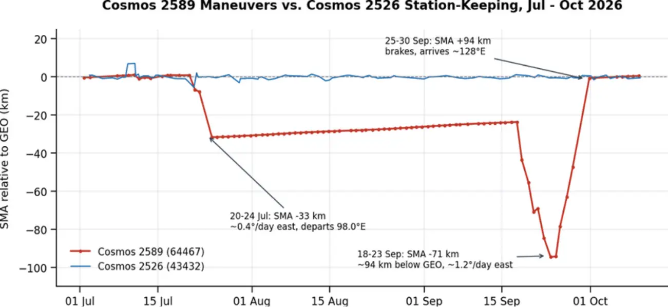
Jul–Oct 2026: Cosmos 2589 SMA Changes (red) vs. Cosmos 2526 Routine Station-Keeping (blue) (based on data from celestrak.org)
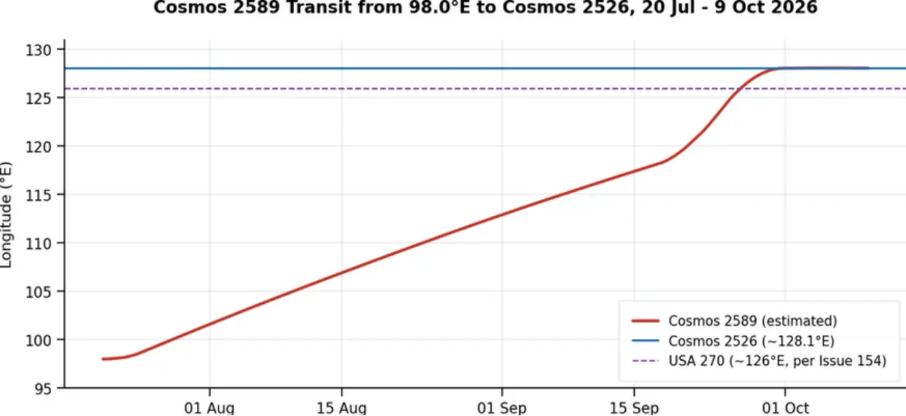
20 Jul–9 Oct 2026: Cosmos 2589 Transits ~30° East, Passes USA 270 & Parks Next to Cosmos 2526 at ~128.1°E. (based on data from celestrak.org)
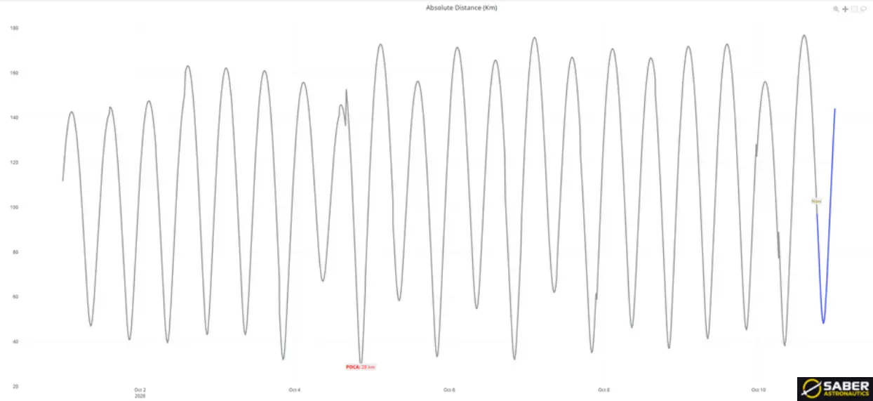
1–10 Oct 2026: Absolute Distance Between Cosmos 2589 & 2526 Cycles Between ~30-175km Primarily Due to Inclination Difference (saberastro.com)
Natural Motion Circumnavigation?
As of 10 Oct 2026 Cosmos 2589 has not adjusted its orbit to enter into what’s called a Natural Motion Circumnavigation (NMC) of Cosmos 2526. In NMC one satellite naturally circles the other without requiring any maneuvers. As Cosmos 2589 has not matched Cosmos 2526’s SMA exactly (2589 is about 1km higher than 2526), 2589 is slowly sliding to the west of 2526. If Russia gives Cosmos 2589 a few tiny nudges, it could stop the sliding and keep circling its neighbor.
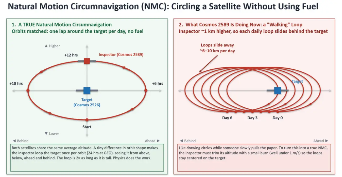
Graphic Explanation of NMC. With small, well-timed maneuvers Russia could place Cosmos 2589 into NMC conditions with Cosmos 2526, but has yet to do so. (based on data from celestrak.org)
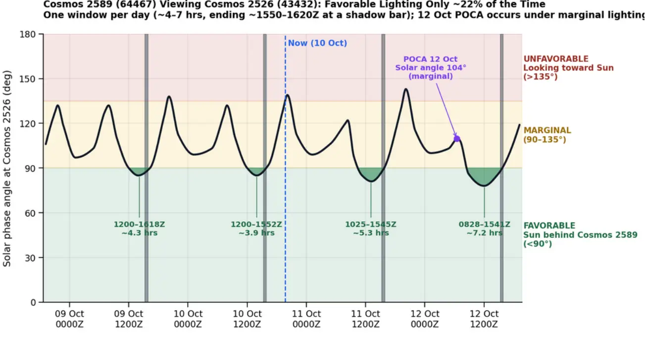
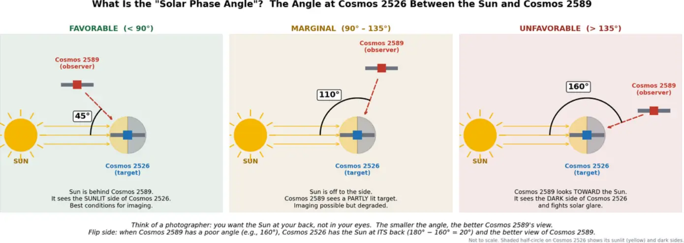
Solar Conditions: I was surprised to see Russia placed Cosmos 2589 into an orbit with limited opportunities to view Cosmos 2526 under favorable lighting conditions. From 9-12 October, the solar phase angle (the Sun–Cosmos 2526–Cosmos 2589 angle) dropped below 90° only once per day, for about 4–7 hours. Each window ended between 1550Z and 1620Z, and favorable lighting covered about 22% of the period. The two satellites’ 12 October point of closest approach (POCA) falls at a 104° solar phase angle, which is marginal for Cosmos 2589. The geometry is more favorable in the other direction. For roughly three-quarters of each day, the Sun is behind Cosmos 2526 relative to Cosmos 2589, which gives Cosmos 2526 the better view of Cosmos 2589. This advantage peaks twice daily, around 0800Z and 2000Z. Cosmos 2526 is a Blagovest communications satellite, and it has no publicly known imaging capability.
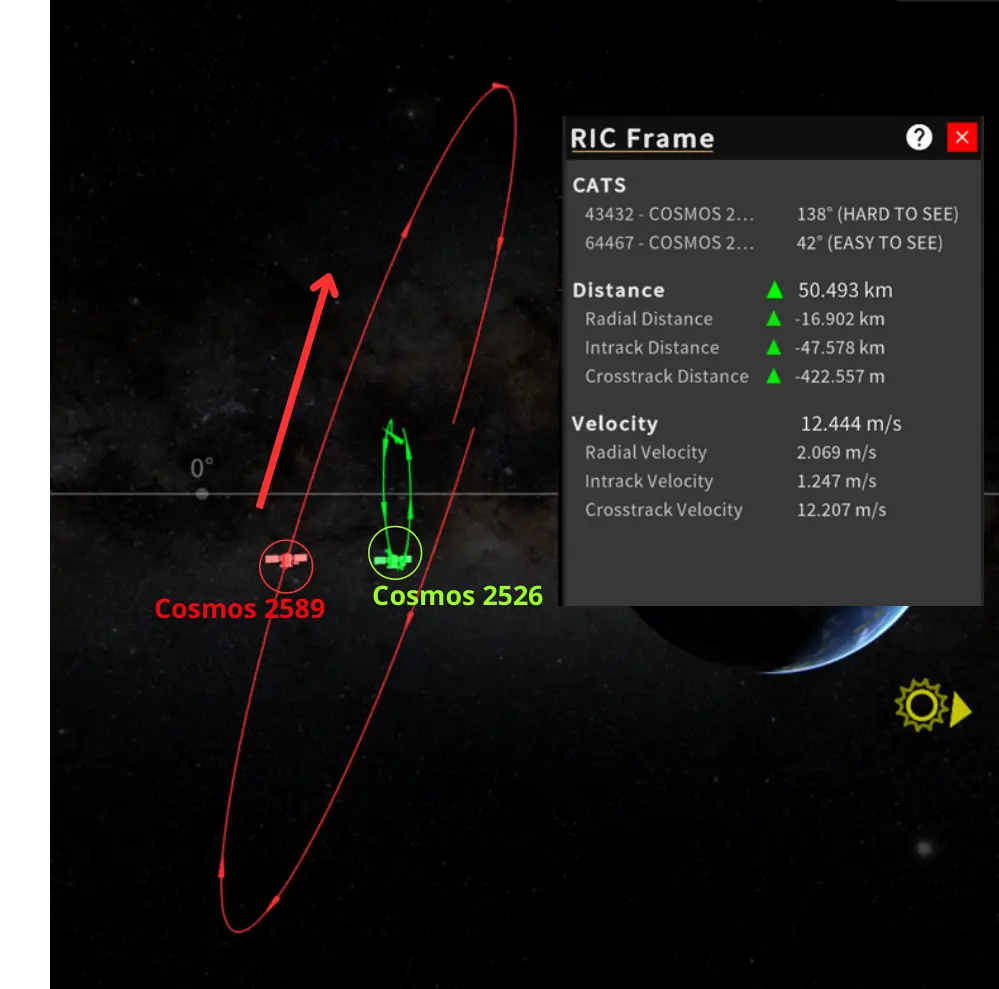
10 Oct 2026 1947Z: As Cosmos 2589 Orbits from South to North it has a POCA of ~50km with Cosmos 2526. Solar conditions are unfavorable for Cosmos 2589 to Image Cosmos 2526. (saberastro.com)
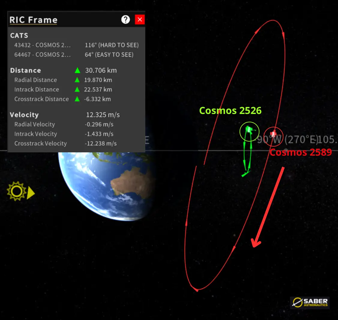
11 Oct 2026: As Cosmos 2589 Orbits from North to South it has a POCA of ~30km with Cosmos 2526. Solar conditions are improved from South-North Transit but still unfavorable for Cosmos 2589 to Image Cosmos 2526. (saberastro.com)
Editor’s Comment: This is Cosmos 2589’s first observed RPO with a satellite other than its own sub-satellite. Pairing with a friendly, Reshetnev-built Blagovest points to a rehearsal, or a test of proximity sensors against a cooperative target. If the goal is close inspection, though, Russia isn’t there yet. From its current orbit, Cosmos 2589 has favorable lighting on Cosmos 2526 only ~22% of the time, in a single 4–7 hour window each day. Its closest approaches happen under marginal solar conditions (104° at the 12 Oct POCA). I see two likely explanations: 1) Russia may not be done maneuvering. Look for small SMA trims to halt the drift, and possibly a plane-match burn (~11 m/s) to improve the viewing geometry; or 2) Cosmos 2589 may be setting up to release another sub-satellite. A smaller, more agile daughter craft could do the close-in work, much as Cosmos 2590 did against its parent in 2025. We don’t know Cosmos 2589’s mission, and none of this is confirmed. Getting sporty. Stay tuned!
Russia: Cosmos 2612 – Climbing Out to Fall Back In
30 Sep – 10 Oct 2026: Cosmos 2612 (68762) raised its average altitude ~46.5 km (544.2 → 590.7 km). The maneuver required a delta-v of ~25 m/sec. Additionally, on 7 Oct Russian space operators conducted a small cross-track burn that raised its inclination ~0.03° (97.870° → 97.901°) for another ~4 m/sec. This is the first significant maneuver by any of the five Cosmos satellites since Cosmos 2613’s ~6 km raise in early July, and it is the first time one of them has broken away from the tightly clustered altitude band they have shared with ICEYE X36 (59103) since May.
At first glance a 47 km climb looks like 2612 is leaving the group. The orbital history suggests the opposite: Russia appears to be using altitude and the Earth’s oblateness (J2) to steer 2612’s orbital plane back into alignment with its four siblings, Cosmos 2610, 2611, 2613 and 2614.
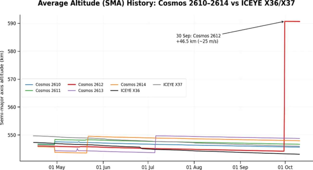
One of these Things is Not Like the Others: Comparing SMA Values May-Oct 2026 (based on data from celestrak.org)
Recap: In Issue 146 (1 Jun) we reported that Cosmos 2610–2614 executed ~0.8° plane changes in mid-May that left all five nearly co-planar with the Finnish/US SAR satellite ICEYE X36. In Issue 152 (23 Aug) we noted the planes had stayed aligned, Cosmos 2613 had raised its SMA ~6 km, and all five Cosmos were stacked 0.6–5.2 km above X36 with slightly different periods, slowly phasing through the plane. Cosmos 2612 was the lowest of the five, just +0.6 km above X36. It is now the outlier by a wide margin.
The Problem: 2612’s Plane Was Drifting Away: In a sun-synchronous orbit (~97.8°), J2 rotates the orbital plane (RAAN) eastward about 1°/day, and the rate depends on altitude: lower satellites precess slightly faster. After the May plane changes, 2612 sat 1.5–4.5 km below its siblings, so its plane steadily pulled ahead of theirs.
- 22 May: 2612 was effectively co-planar with Cosmos 2610 (−0.04°) and Cosmos 2613 (−0.16°), and within ~0.6° of 2611 and 2614.
- 29 Sep: The offsets had grown to +0.88° (2610), +1.40° (2611), +1.24° (2613) and +2.11° (2614), roughly 100–250 km of maximum cross-track separation.
Left alone, that gap would only widen at ~0.005–0.010°/day. 2612 was gradually separating from the formation.
The Fix: Climb and Let J2 Do the Work
Raising 2612 ~47 km above the group reversed the relationship. 2612 now precesses at ~1.003°/day versus 1.011–1.016°/day for its siblings, so their planes are now catching up to 2612’s. If there are no further maneuvers, 2612’s plane will pass through each sibling’s plane in turn:
- Cosmos 2610: ~6 Dec 2026 (0.73° to go at ~0.013°/day)
- Cosmos 2611: ~13 Jan 2027 (1.25° at ~0.013°/day)
- Cosmos 2613: ~28 Feb 2027 (1.14° at ~0.008°/day)
- Cosmos 2614: ~early Jun 2027 (2.01° at ~0.008°/day)
This is the economical way to move a plane in LEO. Removing ~0.9° of RAAN offset with a direct cross-track burn would cost ~115–120 m/sec, roughly as much as the entire May plane change. The climb cost ~25 m/sec, and descending back to the group’s altitude once aligned should cost about the same, for a round trip of ~50–55 m/sec. The trade is time: the realignment takes months instead of minutes.
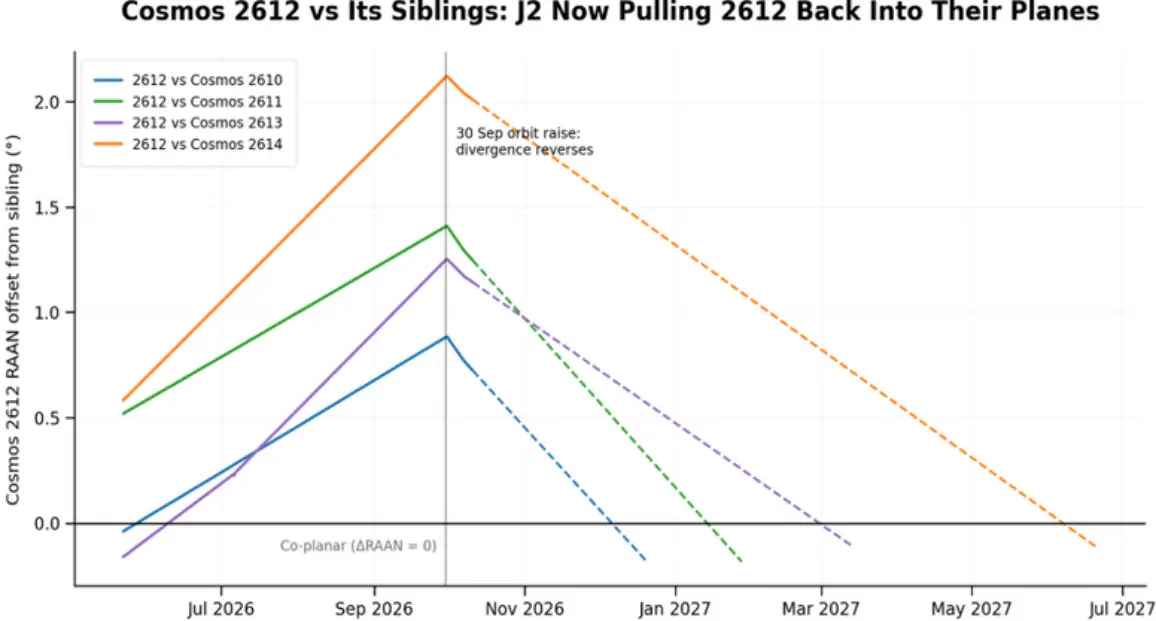
Cosmos 2612's Orbit Plane Now Converging with its Siblings’ Due to September Maneuver (based on data from celestrak.org)
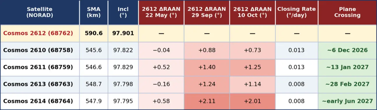
For the “Left-Brainers”: Table Showing Planar Differences between Cosmos 2612 & it’s siblings. (based on data from celestrak.org)
Five months after their plane-change maneuvers, Cosmos 2610–2614 are steadily losing their plane alignment with ICEYE X36. Because the Cosmos satellites sit a few kilometers higher than X36, their orbital planes precess slightly slower, and the gap grows a little each day. Since late May, the angle between their planes and X36’s has grown to 0.7° for Cosmos 2610, 1.1° for 2613, 1.2° for 2611 and 2.0° for 2614, equal to roughly 85–240 km of maximum cross-track separation. Cosmos 2612’s 30 Sep climb brought it back through X36’s plane in mid-October, but then it will separate about twice as fast as its siblings. The relationship with ICEYE X37 runs the other way. X37 is orbiting ~3km higher than X36 and its precession rate is between X36’s and the Cosmos group’s, so the group is sweeping across its plane. Cosmos 2614 passed within 0.05° of X37’s plane in mid-July and is now separating. Cosmos 2613 (0.2°) and 2611 (0.1°) are converging and should cross X37’s plane around 6 and 15 November. Cosmos 2610 (0.6°) is closing more slowly. The pattern fits natural, altitude-driven drift better than a deliberate effort to stay plane-matched with either ICEYE satellite. None of the five has made a maneuver to hold alignment.
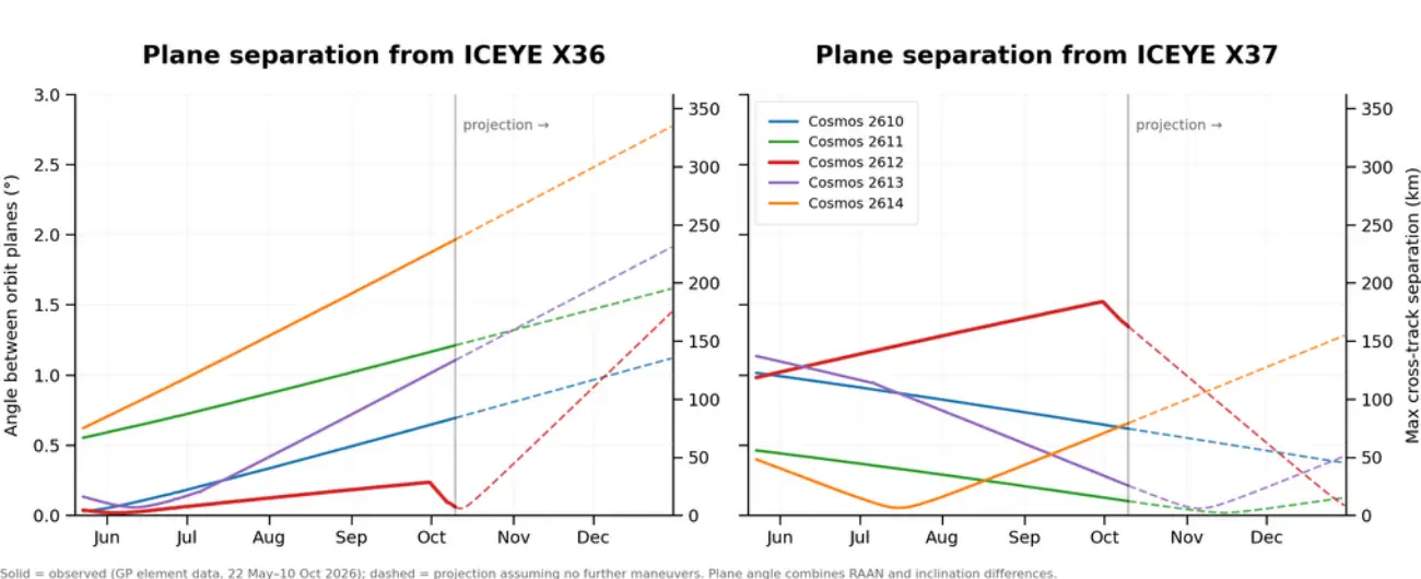
Orbit Planes for Cosmos 2610-2614 Diverging from ICEYE X36, Closing (for the most part) on X37 (based on data from celestrak.org)
Editor’s Comments: I still have no idea what Russia is accomplishing with these 5 satellites. Cosmos 2612’s maneuvers make me wonder if X36 or X37 are of any interest at all. Before the maneuver, 2612 was arguably the best-positioned Russian satellite for X36: nearly co-planar and only ~0.6 km higher, so the two satellites drifted past each other slowly. The ~47 km climb changed that relationship. 2612 now sweeps past both ICEYE satellites roughly once a week, and 2612’s orbital plane is now MOVING AWAY from X36’s at ~0.018°/day. Its 7 Oct inclination burn also widened, rather than closed, the inclination gap with both ICEYE satellites. The picture is different relative to its siblings. 2612’s lower altitude had let its plane drift 0.9–2.1° away from Cosmos 2610, 2611, 2613 and 2614 since May. The climb reversed that drift, and with no further maneuvers 2612 will pass back through each sibling’s plane over the coming months, starting with Cosmos 2610 in early December. Taken together, the maneuvers look more like a cheap way to rejoin the formation than any attempt to get closer to ICEYE.

China: Kings on the Move – TJS-17 & TJS-19 Relocating
30 Sep – 9 Oct 2026: China has started relocating two more of its "Four Kings" satellites. Between 28 September and 1 October, Chinese space operators raised the semi-major axis (SMA) of TJS-17 (63524) "King of the North" ~202km, placing it above the GEO belt and starting a westward drift of ~2.6°/day out of the 165.0°E slot it had held since August 2025. This is TJS-17's second relocation. About a week later, from 7-9 October, operators lowered TJS-19 (63924) "King of the South's” SMA ~197km, placing it below GEO and starting an eastward drift of ~2.5°/day out of 141.4°E. It is the first relocation for TJS-19, which had not made a significant maneuver since arriving in GEO in May 2025.
The two moves came close on the heels of the TJS-15 (63157) "King of the West" relocation from 94.4°E to 88.7°E, which put it near WGS F4 (38070) and which we covered in Issue 153. Of the four Kings, only TJS-16 (63397) "King of the East" remains in the slot it moved to in August 2025 (160.6°E). China continues to describe all four satellites with the same mission statement: they are "mainly used to verify multi-band and high-speed satellite communication technology." Their actual mission remains unknown.
Crossing paths: Because they are drifting in opposite directions, TJS-17 and TJS-19 came within 500km of one another twice between 8-9 October near 141–142°E. Their inclinations differ (1.35° vs 3.11°), so the encounters were brief. On 8 Oct 2132Z the two satellites were <400km apart with TJS-17 having favorable solar conditions for observing TJS-19 as TJS-17 approached from the east. On 9 Oct at 0928Z the two satellites were within ~450km of one another, again TJS-17 had favorable solar conditions. I should note that due to the ranges neither satellite would likely be capable of capturing resolved imagery of the other.
This story is still unfolding and we don’t know the destination yet. If the drift rates hold, TJS-17 covers ~18° per week and TJS-19 ~17.5° per week. We will report where (and next to whom) each King settles.
28 Sep -10 Oct 2026: Kings Family Photo showing ongoing relocation of TJS-17 heading West and TJS-19 heading East. (saberastro.com)
The Four Kings: A Brief History
China launched all four Kings in a 64-day window in the spring of 2025. During the first six months of 2025, China launched more TJS satellites than in any previous full year.
How Much Fuel Have the Kings Used?
Using each satellite's orbital history, we estimated the Δ v each King has spent since it parked in GEO. The estimates exclude the transfer from GTO. The totals are modest:
- TJS-15 (~38.0 m/s): Highest of the four. About 28 m/s is cross-track, and most of that comes from a single ~22 m/s inclination change on 15 July 2025. Two relocations account for the remaining ~10 m/s in-track. It is the only King we have seen actively managing its inclination.
- TJS-16 (~5.4 m/s): One relocation (August 2025) plus minimal east/west station-keeping.
- TJS-17 (~13.7 m/s): Two relocations, with the October 2026 maneuver accounting for more than half.
- TJS-19 (~8.8 m/s): Mostly the current relocation (~7.2 m/s).
TJS-16, -17 and -19 have not performed north/south station-keeping, and their inclinations have grown naturally (to 1.39°, 1.35° and 3.11°, respectively).
China Launches Guowang Group 27
7 Oct 2026: China launched a Long March-12 with the 27th group of Guowang (China SatNet LEO) satellites from Wenchang. According to official sources, the 9 satellites (100973-100981) entered the preset orbit successfully. As with other Wenchang launches, China placed the satellites into an 50.0° inclined orbit. China launched Group 27 into an orbit only 14° east of Group 13. The LM-12 delivered its payload into 920km orbits, the satellites will slowly increase their altitudes to reach the desired 1,149km. Watch Group 27 Launch Video.
DEPLOYMENT UPDATE: Guowang Groups 24 (1,100km), 25 (940km) & 26 (1,136km) continue to raise their orbits. None have yet to reach the operating altitude of 1,149. Group 26, which used an improved LM-8A to launch its 9 Group 26 satellites into a significantly higher orbit >1,100km is less than 15km from reaching their operational altitudes.
CONSTELLATION OVERVIEW: There are now 222 operational Guowang satellites in LEO (there are also 3 GEO satellites associated with Guowang). As of 11 Oct 2026, 23 of 27 Guowang groups have reached their operational altitudes. With a stated goal of reaching 310 satellites on orbit by 2027, China will need to launch 88 satellites in the next 2.5 months.
22 Sep 2026: Group 25 Launched into 920km orbit. Group 25 will increase altitude over next 2-3 months allowing RAAN precession differences to result in co-planar orbit with Group 6. (saberastro.com)
Orbital Planes for Guowang 50° Inclined Groups (saberastro.com)
Constellation Overview Graphics: The Following Graphics are based on data from Celestrak.org.
Seven Sons: Beihang University
by Ron Lerch
Previously in our series of discussing the Seven Sons of National Defense, we highlighted the efforts of the Harbin Institute of Technology and their research geared towards manipulating uncooperative targets in space. This week, we will examine the Beihang University. Founded in October 1952, Beihang University is the first institution of higher education in aeronautics and astronautics established after the founding of the People’s Republic of China in 1949. Currently, Beihang has over 48,000 students and more than 6,200 faculty and staff, including 31 members of the Chinese Academy of Sciences and the Chinese Academy of Engineering.
Beihang was among the first Chinese universities to establish dedicated programs in rocket design and rocket engines, beginning in the 1950s. Its School of Astronautics has spent more than six decades supporting China's aerospace industry through research, workforce development, and advanced technology programs. Numerous leaders, engineers, and technical specialists in China's space sector have been trained at Beihang. One of the university's more visible achievements is its work on the Asia Pacific Space Cooperation Organization. Student Small Satellite (SSS-1). This 30 kg satellite was developed through an international cooperative program and launched from Taiyuan Satellite Launch Center in October 2021.
Graduates Joining CASC Upon Graduation (CSET)
So how has their research contributed to national security efforts? Beihang University personnel authored an article discussing pulsar-based positioning as an alternative to Global Navigation Satellite System (GNSS). In 2022, authors from the University produced “Adaptive Orbital Rendezvous Control of Multiple Satellites Based on Pulsar Positioning Strategy.” Researchers offered a look into potentially using pulsar-based positioning technology, which allows orbital vehicles to locate themselves by comparing the received signals from pulsar sources with a database of known pulsars and locations. They refer to it as the next-generation navigation technology for orbiting or interplanetary spacecraft and an alternative calibrated source for GNSS. While this may sound similar to star trackers, pulsar-based positioning uses radio pulses from pulsars, as opposed to optical positions of stars. In the authors’ own words, the main contribution of this paper is “presenting the design and analysis of a novel adaptive rendezvous strategy for multiple uncertain orbital satellites with an initial pulsar-based positioning method.“
But what have they researched more recently? In the past few years, authors from Beihang have published work covering issues such as autonomous rendezvous and proximity ops, spacecraft swarming, navigation reslience, and even leveraging artificial intelligence (AI) in cislunar space. The most consequential trend since 2024 is their convergence of AI, spacecraft autonomy, and cislunar situational awareness.
In 2025, personnel associated with Beihang authored “Research Progress and Prospects of Artificial Intelligence-Enabled Space Situational Awareness (SSA) Technology in Cislunar Space.” Auhors discussed specific areas where AI could benefit cislunar SSA. For example, in terms of object detection and recognition, researchers highlight the use of the You Only Look Once (YOLO)-T model. YOLO-T improved off the YOLOv2 architecture by introducing an attention mechanism and multiscale feature fusion techniques, achieves an F1 score in machine learning of 0. 95 in object detection tasks under complex starry backgrounds. In other words, this YOLO-T model is correctly identifying almost all positive cases while minimizing false positives. This research is an example of how Beihang helping determine the best ways to monitor spacecraft near the Moon and establish future cislunar awareness architecture. Most recently this year, researchers published “Learning-Based Model Predictive Control for Cooperative Spacecraft Swarm Reconfiguration.” Overall, this paper dicusses spacecraft swarm reconfiguration, reinforcement learning (RL), decentralized spacecraft control, collision avoidance, and autonomous maneuver planning. There is significant military relevance regarding these topics, as they could be applied to distributed military constellations, autonomous ISR satellite formations, spacecraft swarming, and responsive operations.
Its clear that Beihang has had significant influence in China’s space programs from its earliest stages. The university’s research on alternative GNSS, integration of AI, and cislunar awareness clearly reflect priority areas for civil and military space leaders. Future research coming from Beihang is certainly worth keeping an eye on.
India’s New View from GEO: EOS-05 and the Next Phase of Indian Space Power
By Dr. Larissa Beavers
India’s newest Earth-observation satellite represents more than another successful launch. On 4 September 2026, the Indian Space Research Organisation (ISRO) launched EOS-05 (100607) aboard GSLV-F17 from the Satish Dhawan Space Centre. ISRO describes EOS-05 as India’s first imaging satellite operating from geosynchronous orbit—a capability that changes how frequently India can observe its territory and surrounding region. Rather than waiting for a low-Earth-orbit satellite to pass over an area of interest, a geosynchronous imaging spacecraft can maintain continuous access to roughly the same region of Earth. EOS-05 therefore marks an important step in India’s progression from periodically observing its surroundings to maintaining persistent regional awareness. On 29 September, EOS-05 successfully parked at 86.5°E. (see Figure 3)
Figure 1: ISRO’s GISAT 1A NewsBytes
Figure 2: ISRO Preparing for GSLV- F17 Launch
From Communications and Weather to Persistent Imaging
India has operated geosynchronous satellites for decades. Its INSAT and GSAT families support communications, broadcasting, and meteorology, while spacecraft such as Kalpana-1, INSAT-3D, and INSAT-3DR provided continuous weather observations. India’s Earth-observation program developed largely in low Earth orbit (LEO), beginning with IRS-1A in 1988 and expanding through Cartosat, Resourcesat, RISAT, and other optical and radar-imaging satellites.
EOS-05 brings these capabilities together by combining the persistent regional access of GEO with Earth imaging traditionally performed from LEO. The concept was attempted with EOS-03/GISAT-1 in 2021, but the spacecraft was lost after the GSLV-F10 upper stage failed. EOS-05 finally brings that GEO-imaging capability to orbit.
Why GEO Imaging Matters
EOS-05 adds persistence to India’s Earth-observation architecture. From geosynchronous orbit, it can repeatedly observe India and surrounding areas, with selected regions imaged approximately every five minutes and the Indian landmass about every 30 minutes. This provides greater ability to monitor rapidly changing events such as severe weather, flooding, fires, disasters, and other regional activity.
Figure 3: 29 Sep 2026 EOS-05 Parks at 86.5°E
The capability also has national-security value. EOS-05 does not replace higher-resolution Cartosat or radar-imaging satellites; it complements them. GEO imagery can provide persistent wide-area awareness and identify developing activity, while LEO satellites can provide more detailed observations. This combination strengthens India’s ability to independently monitor a strategic region extending from the Himalayas across the Indian Ocean.
Part of a Larger Space Expansion
EOS-05 is one component of a much broader Indian space expansion. India’s Space Vision 2047 includes the Bharatiya Antariksh Station (BAS) – Figure 3 – by 2035 and an Indian crewed lunar landing by 2040. Planned programs also include Chandrayaan-4, the Venus Orbiter Mission, additional Gaganyaan missions, and a reusable Next Generation Launch Vehicle.
India is simultaneously expanding its commercial space sector. The Indian Space Policy 2023 opened more of the space economy to private industry, while IN-SPACe aims to grow India’s space economy from approximately $8.4 billion in 2022 to $44 billion by 2033. Together, these developments point toward a more diverse space architecture spanning persistent Earth observation, navigation, launch, human spaceflight, exploration, and commercial services.
What Comes Next
EOS-05 consequently represents something larger than a new satellite. It illustrates how India's space architecture is becoming increasingly layered. LEO remote-sensing satellites provide detailed observations; GEO platforms provide communications, weather monitoring, and now persistent imaging; NavIC supplies regional positioning, navigation, and timing; GSLV and LVM3 provide increasingly capable indigenous launch options; and planned human-spaceflight and exploration programs are pushing India toward sustained operations beyond Earth. The significance is therefore not that EOS-05 suddenly transforms India into a new space power. India has possessed substantial space capabilities for decades. Instead, EOS-05 demonstrates the increasing breadth and integration of those capabilities.
India is moving from a space program built primarily around individual national missions toward an architecture in which different orbital regimes and mission areas reinforce one another. Persistent GEO imaging is another piece of that architecture—and, viewed alongside India's planned space station, lunar missions, next-generation launch vehicle, expanding private sector, and growing Earth-observation infrastructure, it provides a useful indicator of where the Indian space program intends to go next.
Cyber Series Part 3 - The Long Way to Orbit: Ground Systems as a Gateway to Space
By Dr. Larissa Beavers
A satellite may ultimately operate hundreds or thousands of kilometers above Earth, but the person controlling it does not. Commands begin on the ground. Telemetry returns to the ground. Software is maintained on the gorund. Mission data is processed on the ground. Operators authenticate through terrestrial networks, computers, servers, antennas, and increasingly cloud-based infrastructure. Before a command ever reaches a spacecraft, it may travel through an extensive digital ecosystem. For an adversary seeking to affect a satellite, that shortest cyber path to space may therefore never leave Earth.
The Satellite Doesn’t Operate Alone
NASA’s current description of ground systems includes mission operations software, data processing, communications infrastructure, and increasingly virtual/cloud-based science operations centers. NASA also notes that ground operations can be distributed across multiple locations and commercial providers.
Figure 1:Example of a ground system architecture for a small satellite using NASA’s Near Space Network NASA
The ground segment extends far beyond the antenna, as seen Figure 1. Mission operations, engineering teams, data processing, ground networks, and command-and-telemetry pathways work together to support and control the spacecraft. Each connection also represents a dependency that must be protected from cyber threats.
More Than an Antenna
When most people picture the ground segment, they probably imagine a large antenna pointed toward the sky, such as Figure 2. That antenna is important—but it is only one part of a much larger system. A modern ground segment can include mission operations centers, ground stations, communications networks, servers, operator workstations, remote terminals, data-processing systems, and the software connecting them. NASA describes ground-station software performing functions ranging from antenna control and pass scheduling to command generation, encryption, signal processing, and communications with the mission operations center. Figure 3 shows how these functions rely on a geographically distributed network of ground stations and supporting infrastructure.
Figure 2: Antenna dish at NASA’s Deep Space Network Complex, CA. NASA
Figure 3: NSN Global Ground Station Locations NASA
NIST consequently treats the ground segment as a critical component of the broader space cyber ecosystem. Its Satellite Ground Segment: Applying the Cybersecurity Framework to Satellite Command and Control specifically focuses on protecting ground systems involved in commanding satellite buses and payloads.
This creates an important distinction. A satellite can be physically inaccessible to an attacker while parts of the infrastructure supporting it remain digitally accessible. The ground segment relies on technologies familiar to almost any cyber professional: operating systems, networks, applications, credentials, servers, remote access, software, and increasingly cloud infrastructure. The United Kingdom's 2025 assessment of cloud computing in space ground segments similarly identified authentication, access controls, interfaces, cloud networks, antenna controllers, mission-management systems, and data flows as areas requiring cybersecurity protection. The antenna may be where the signal leaves Earth, but the cyberattack surface begins long before the signal reaches the dish.
Follow the Command
Consider that happens when an operator needs a satellite to perform an action. The command does not magically appear at the spacecraft. At its simplest, the pathway might look something like (Figure 4):
NASA's current cybersecurity guidance makes this pathway particularly important. Its 2026 small- spacecraft guidance identifies the end-to-end command path as a particularly accessible route for a remote adversary. Potential paths include interference through the RF link, compromise of transport networks, and compromise of command authority such as an operations center. That does not mean compromising a workstation automatically gives an attacker control of a spacecraft. Authentication, encryption, network segmentation, command validation, access controls, and other safeguards may stand between an initial compromise and the satellite. But it changes the cybersecurity question. Instead of asking only: “How could someone hack the satellite?” We should also ask: “What systems does the satellite trust—and how could an attacker reach them?”
When the Attack Stays on Earth
The danger is not theoretical. One of the clearest recent examples occurred on February 24, 2022, when a cyberattack disrupted Viasat's KA-SAT satellite communications network as Russia began its full-scale invasion of Ukraine. The European Union subsequently attributed the malicious activity to the Russian Federation and reported communications disruptions affecting Ukraine and several EU member states. What makes KA-SAT especially important to understanding ground-segment cybersecurity is where the compromise occurred. According to Viasat's investigation, the attacker exploited a misconfigured VPN appliance to gain remote access to a trusted management segment. The attacker then moved laterally through the network until reaching infrastructure used to manage the service. From there, legitimate management commands were used against large numbers of residential modems, overwriting data in their flash memory and preventing them from accessing the network. Tens of thousands of modems dropped offline across Europe.
Figure 5: ViaSat KA-SAT Cyberattack
Researchers later identified destructive malware associated with the incident as AcidRain, designed to wipe modems and routers. But one fact is especially important: The KA-SAT satellite itself was not compromised. Viasat reported no evidence that the spacecraft or its supporting satellite ground infrastructure was directly impaired or compromised. Yet the attack still disrupted the satellite-enabled service. That distinction captures one of the central themes of this series: An attacker does not necessarily need to control a satellite to affect the mission it supports.
2023: Dozor-Teleport
Another example emerged in June 2023. A cyberattack disrupted Dozor-Teleport, a Russian satellite communications provider whose customers reportedly included Russian government organizations and military users. Reporting stated that the system was rendered largely nonfunctional for roughly a day and that some customers had to be moved to terrestrial networks. Independent network observations confirmed that Dozor-Teleport became unreachable from the internet. The Cyber Defense review released information about the intrusion and is considerably less complete than for KA-SAT, and competing groups claimed responsibility. It, therefore, should not be treated as evidence of a specific attack method or confidently attributed actor. But it provides another useful operational lesson: Disrupting terrestrial infrastructure supporting satellite communications can disrupt the service without physically attacking the satellite.
Figure 6: Dozor-Teleport Connectivity Disruption, June 2023 X
Internet connectivity associated with Dozor-Teleport (AS41942) dropped sharply on June 29, 2023, during the reported cyberattack against the Russian satellite communications provider (Figure 6). The observed outage illustrates how disruption of terrestrial network infrastructure can affect satellite-enabled services without physically targeting a spacecraft.
Protecting More Than the Satellite
The ground segment continues to evolve as space organizations increasingly rely on commercial providers, cloud services, remote access, and distributed infrastructure. These capabilities can improve flexibility and access, but they also introduce additional networks, interfaces, credentials, software, and third-party dependencies that must be protected. Cybersecurity must therefore extend beyond the spacecraft to the terrestrial systems and organizations supporting the mission (Figure 7).
Recent incidents reinforce this point. A compromise of a corporate network does not necessarily provide access to mission systems, just as compromising a ground network does not automatically provide command authority over a satellite. Each represents a different level of access with different potential consequences. Effective security therefore depends on protecting credentials, networks, software, command pathways, and the systems responsible for processing and transmitting mission data. NIST recommends approaching ground-segment cybersecurity in the context of the entire mission, rather than protecting individual components in isolation (Figure 8).
Ultimately, the significance of a ground-system compromise depends on the effect it produces. An attacker may seek to steal information, disrupt communications, manipulate data, or—in a more serious compromise—attempt to reach systems involved in spacecraft command and control. The cyberattack surface does not stop at the edge of the spacecraft. It stretches from the operator's keyboard to orbit.
Cyber Series Part 4 Teaser
But reaching the spacecraft is only part of the story. Once a command reaches a satellite, it must be received, processed, and acted upon by specific subsystems—and the consequences can vary dramatically depending on which subsystem is affected.
Next in the Cyber Series: Inside the Satellite — When Command and Data Handling Is Compromised. The next question is no longer simply, “How could an attacker reach the satellite?” It is: “What could they affect once they get there?”
Pics o’ the Fortnight!
2.6cm Resolution Image of Gaofen-14 01 (47231) from Vantor’s Legion 01 Satellite. China launched GF-14 01 on 6 Dec 2020 on a LM-3B. GF-14 01 is believed to be capable of panchromatic resolution of 0.6m and a multispectral resolution of 2.4 meters (Vantor Via Linked In, Gunter’s Space Page & Researchgate.com )
“Lesser known things about Starlink. Whatever you want to call it, on top of being an illuminator of opportunity for detection below, the mega constellation can detect everything *from above*. A giant, phased array radar in space.” (@J1MMYJAMJAM via X)
“FIRST OFFICIAL PICTURES OF PLANET 9 CANDIDATE RELEASED! Astronomers analyzing historical infrared data from IRAS (1983) and AKARI (2006) have flagged direct photographic evidence of a massive body shifting 47.5 arcminutes across the deep sky over a 23-year baseline. Estimated at 7–17 Earth masses, this unseen giant could be acting as a cosmic bulldozer—altering outer solar system orbits and redirecting comets into near-Earth trajectories.” (@DobsonianPower via X)
“Earth as seen from X-37B From high above the planet, an onboard camera aboard the X-37B—normally used to check the vehicle’s health—caught this view of Earth in 2024 while the spaceplane ran experiments in highly elliptical orbit.” (@konstructivizm via X )