Issue 157 | November 10, 2026
The integrity flash
Analysis of Developments in the Space Domain
In This Issue
Still Kicking: Russian Subsatellite Stalking USA 326
China: Shiyan-12 02 Makes U-Turn at 178.8°E
China: TJS-3 Settles in with TJS-23
China GEO Relocations: TJS-17, TJS-19 & TJS-24
China: Creating a New LEO ISR Constellation
China: Qianfan Conducts 2nd Commercial Launch
Deploying Guowang: A Closer Look at Groups 22 & 23
Revisiting DIA’s Challenges to Security in Space
Cyber Series Part 5 - Losing the Link
Pics o’ the Fortnight!
Still Kicking: Russian Subsatellite Stalking USA 326
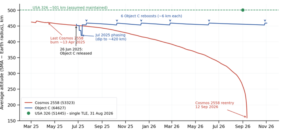
27–28 October 2026: Russia raised the average altitude (SMA) of Object C (64627), the Nivelir-class sub-satellite released by Cosmos 2558 in June 2025, by ~6.1 km (453.0 → 459.2 km). The burn also re-circularized the orbit, dropping eccentricity from 0.00126 to 0.00039. It is Object C’s sixth stationkeeping reboost since July 2025, and each one has followed the same script: let the orbit decay to ~453 km, then climb back to ~459 km. Meanwhile, its parent is gone. Cosmos 2558 (53323), which stopped orbit maintenance in April 2025, reentered on 12 September 2026.
The Latest Maneuver
- Timing: Between the 27 Oct 0707Z and 28 Oct 1731Z.
- Change: SMA +6.1 km (453.0 → 459.2 km); eccentricity 0.00126 → 0.00039.
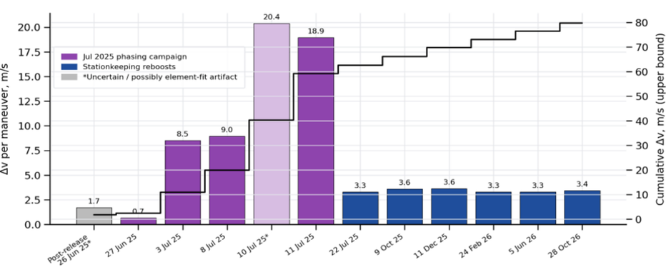
- Cost: ~3.4 m/s, in the same range as the previous five reboosts (3.3–3.6 m/s each).
- Cadence: The interval between reboosts has stretched from 63–78 days in late 2025 to 101 days (Feb–Jun 2026) and now 145 days (Jun–Oct 2026). Object C’s decay rate fell from ~0.08–0.10 km/day to ~0.04 km/day, consistent with lower atmospheric drag, likely due to a decline in the solar cycle.
Object C vs. USA 326
Unfortunately there is a paucity of orbital data for USA 326 (51445). The most recent orbital data we have is a single TLE from 31 Aug 2026 2254Z. Here is a comparison with Object C’s orbit at that time:
| Parameter (31 Aug 2026) | USA 326 | Object C | Difference |
|---|---|---|---|
| Average altitude (SMA) | 500.6 km | 455.4 km | 45.2 km (USA 326 higher) |
| Inclination | 97.397° | 97.230° | 0.17° |
| RAAN | 338.74° | ~338.43° | 0.31° |
| Eccentricity | 0.00036 | 0.00096 | — |
| Orbital period | 94.6 min | 93.7 min | Object C laps USA 326 every ~6.6 days |
| Angle between orbital planes | — | — | ~0.35° |
The two orbits are nearly co-planar but not identical. A 0.35° plane offset produces at most ~42 km of cross-track separation, while the altitude difference keeps the pair ~45 km apart radially. As a result, the best-case close approach is about 45 km. That matches the 44 km point of closest approach we reported in August 2025, and the ~6.6-day lap time lines up with the roughly weekly close approaches noted in the 20 Jul 2025 Flash. We can’t compute current close-approach times without a full, current element set for USA 326. USA 326 orbital data is not published in the space-trak.org catalog, so instead we rely on information from the McCants catalog.
Close Approaches Around the Latest USA 326 TLE
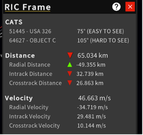
To see what those encounters look like, we propagated a 31 Aug 2026 element set for each satellite ±7.5 days (24 Aug – 8 Sep 2026), covering two full lap cycles, and plotted Object C’s position relative to USA 326 in radial, in-track and cross-track (RIC) components.
| # | Closest approach (UTC) | Range | R / I / C (km) | Lighting at closest approach | Best sunlit look |
|---|---|---|---|---|---|
| 1 | 28 Aug 2026 23:57 | 53 km | −45 / +15 / +24 | Both in Earth’s shadow (26°N) | 00:06Z, 68 km, as both exit shadow |
| 2 | 4 Sep 2026 15:02 | 60 km | −50 / −10 / +32 | Both entered shadow ~1 min | ~15:00Z, ~60 km, at closest |
Both encounters as close as 53–60 km, consistent with the 44–58 km closest approaches we reported in summer 2025. Most of the separation is altitude; the remainder is in-track timing and the cross-track offset from the small plane difference. Neither closest approach occurred in sunlight. Both fell right at the edge of Earth’s shadow.
Caveat: These results come from a single TLE for each satellite. We expect some inaccuracies: timing errors of a minute or two and range errors of a few kilometers near the TLE epoch, growing with time. Encounter #2 is ~3.7 days past both epochs, and a small timing error could shift its closest approach to either side of the shadow boundary. Any USA 326 maneuver after 31 Aug would invalidate the prediction entirely. Treat the geometry as representative, not definitive.
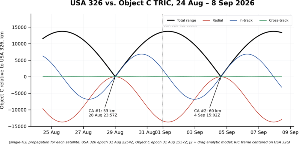
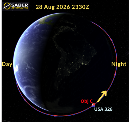
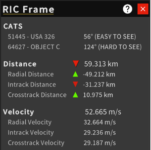
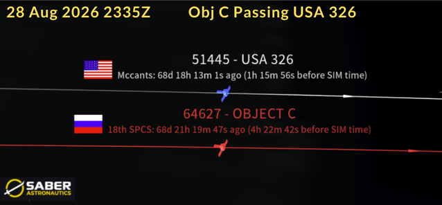
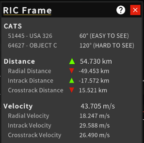
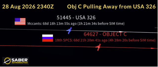
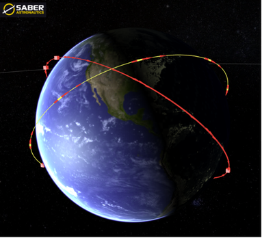
Every 6-7 days Object C passes USA 326. This is done without maneuver and is a function of Object C maintaining a slightly lower (but carefully plane matched) orbit with USA 326. Images depict close approach which occurred on 28 Aug 2026. Close approach happened during orbit “night” so the sun is not illuminating either object.
(saberastro.com)
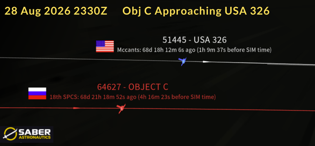
Is Russia Holding Object C in USA 326’s Plane?
It sure seems so, but difficult to be certain due to a lack of current orbital data on USA 326. However, there is strong circumstantial evidence to support a purposeful placement.
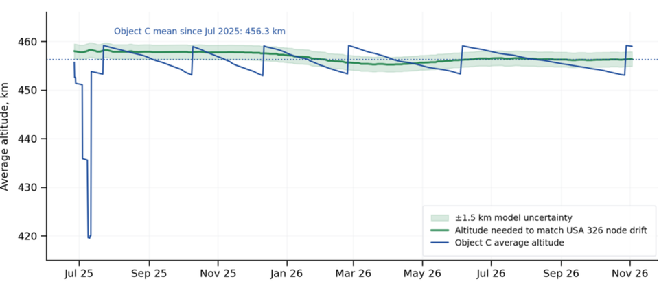
Both satellites are in sun-synchronous orbits (normal for imagery satellites), so Earth’s equatorial bulge rotates each orbital plane (its RAAN) about 1° per day. That rotation rate (also known as the J2 effect) depends on two things: altitude and inclination. To stay co-planar, two satellites don’t need to be at the same altitude or the same inclination. They need the same rate. USA 326 is 45 km higher, which slows its RAAN rotation, and 0.17° more inclined, which speeds it up. The two effects nearly cancel.
That means for Object C’s inclination there is one altitude that keeps its plane turning in step with USA 326’s. Using a J2 model with USA 326’s 31 Aug elements, that altitude is ~456.5 km. Object C’s mean altitude since July 2025 is 456.3 km. Russia’s 453–459 km stationkeeping band is centered almost exactly on the plane-matching altitude.
Two cautions: the result relies on a single USA 326 TLE, and it assumes USA 326 holds its own orbit (as a reconnaissance satellite almost certainly does). The model is accurate to roughly ±1.5 km. Even so, a sub-km match is hard to explain as coincidence. Any satellite has to reboost against drag, but Russia picked this particular altitude to reboost around.
Cosmos 2558: Gone
Cosmos 2558 reentered on 12 Sep 2026, about 17 months after its last orbit-maintenance burn. Through early 2025 Russia flew Cosmos 2558 in a ~459–466 km band, reboosting ~5–6 km every four to six weeks. Its last maneuvers, between 7 and 13 April 2025, were a string of small raises of only 0.25–0.7 km each. After that it stopped maneuvering. We assess the weak final burns may indicate degraded propulsion or propellant depletion. Eleven weeks later, on 26 Jun 2025, Object C separated at ~452 km.
Cosmos 2558 then decayed steadily: it was down to ~300 km by early August 2026 and ~158 km on its final element set (12 Sep 0147Z). The decay also changed its plane. Lower satellites precess faster, so Cosmos 2558’s RAAN pulled away from Object C’s (and USA 326’s), reaching ~15° by reentry. That is what Object C would face without stationkeeping, and it shows why the reboosts matter.
Gas Rationing? Object C Δv Estimate
Using the change in SMA and eccentricity across each maneuver, and assuming efficient in-plane (along-track) burns, we estimate Object C has used roughly 58–80 m/s of Δv since release:
| Activity | Dates | Maneuvers | Est. Δv (m/s) |
|---|---|---|---|
| Phasing campaign (lower to ~420 km, raise to ~454 km) | 27 Jun – 11 Jul 2025 | 5 | 37 – 58 |
| Stationkeeping reboosts (~6 km each) | 22 Jul 2025 – 28 Oct 2026 | 6 | ~20.5 |
| Total since release | 11–12 | ~58 – 80 |
The range in the phasing estimate comes from 10–11 July 2025. Element sets show a large eccentricity change on 10 July followed by a ~34 km raise on 11 July. Treated as one optimized sequence, it costs ~19 m/s; treated as two separate maneuvers, ~39 m/s. Either way, the July 2025 phasing campaign was the largest single expense, at roughly two to three times what Object C has spent on all of its stationkeeping since. These are minimum-impulse estimates.
Looking ahead: Object C’s orbit decays ~0.04 km/day, or ~15 km/year, so holding the 453–459 km band will cost only about 8–9 m/s per year, and more if solar activity picks up. We don’t know how much propellant Object C carried, so we can’t estimate how much remains. Still, a 3.4 m/s burn this October suggests Russia sees no reason to economize yet.
Editor’s Comment
Object C’s behavior is consistent with a deliberate handoff with Cosmos 2558. As Cosmos 2558 stopped maneuvering, its sub-satellite took over the job of staying in USA 326’s plane, and it has done so with regular, low-cost reboosts for over 15 months. The altitude band Russia chose matches the altitude needed to keep Object C’s plane turning with USA 326’s. That is strong circumstantial evidence the co-planar relationship is the point. What we can’t confirm is USA 326’s own orbit since 31 August; if USA 326 maneuvers, we would expect Object C to respond.
China: Shiyan-12 02 Makes U-Turn at 178.8°E
30 Oct 2026: Shiyan-12 02 (SY-12 02, 50322) reversed course at the eastern edge of its GEO patrol on 27–28 October 2026, executing a two-burn turnaround at ~178.8°E that took it from a 0.61°/day eastward drift to an initial 0.77°/day westward drift. The turn landed 231 days after its last reversal, 79 days after SY-12 01’s western turn, and within days of the ~November 2026 window we projected in August. The China GEO inspector trio’s ~120° round-robin remains intact.
This is SY-12 02’s seventh recorded turnaround and its fourth at the eastern limit. The just-completed eastbound leg ran 231 days, close to its 238-day average. The 178.8°E reversal point is the farthest east we have recorded for the satellite, edging past its December 2022 (178.5°E) and March 2024 (178.4°E) turns. It also restores a ~160° swing after two shorter legs that reversed near 170°E and 18.8°E.
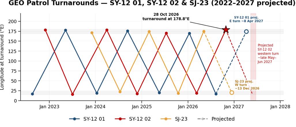
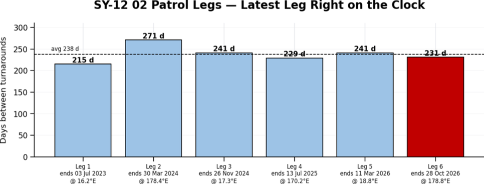
Nearly five years after launch, there is still no sign of north–south stationkeeping, and the plane continues its free drift about the Laplacian pole.
SY-12 01 turned at its western limit (~16.8°E) on 10 August 2026. SY-12 02 followed at the eastern limit 79 days later, close to the ~80–81-day cadence that has held without a miss since early 2024. The sequence remains SY-12 02 → SJ-23 → SY-12 01, which puts SJ-23 up next. It last reversed at ~175°E on 6 May 2026. SJ-23’s average leg points to mid-December 2026, while the round-robin cadence points to mid-January 2027, so we will watch for a western turn in that window.
China: TJS-3 Settles in with TJS-23
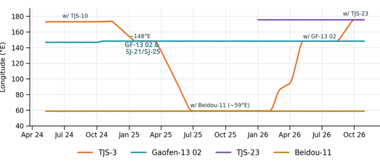
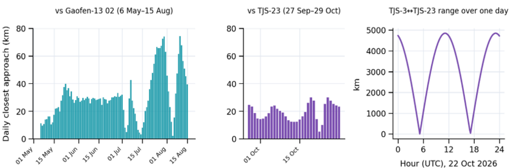
31 Oct 2026: On 27 Sep 2026 Chinese space operators raised TJS-3’s (43874) semi-major axis (SMA) ~52 km. The burn ended a ~40-day eastward drift and parked the satellite at 175.5°E, the same longitude as TJS-23 (67226). TJS-3 had spent the ~102 days before that (6 May–16 Aug) beside Gaofen-13 02 (55912) at 148.2°E. The two stops continue a pattern we have tracked for three years. Since China stopped controlling TJS-3’s inclination in late 2023, the satellite has only operated near other Chinese satellites: TJS-10, Beidou-11 (sort of), Gaofen-13 02 and now TJS-23.
Summer with Gaofen-13 02
As reported in the 18 May Flash, operators lowered TJS-3’s SMA ~121 km on 5 Apr, sending it east from 95.5°E at ~1.8°/day. On 6 May they raised it ~136 km to stop at Gaofen-13 02’s slot at 148.2°E. The two satellites were not plane-matched; the inclination/RAAN difference was ~2.6°. So rather than holding formation, they crossed paths twice a day at roughly 140 m/s and separated by up to ~1,600 km in between. Our model puts the daily closest approach between ~2 and 75 km, consistent with the <20 km and <75 km passes noted in May. Gaofen-13 02 kept to its normal stationkeeping throughout. On 16–18 Aug, TJS-3 lowered its SMA ~51 km and began drifting east at ~0.65°/day.
New Neighbor: TJS-23
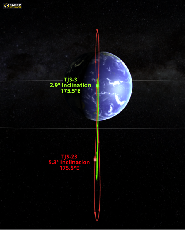
TJS-23 is one of the “Birds of a Feather” we profiled in the 28 Jun Flash. TJS-20, TJS-23 and TJS-25 were all launched on a Long March-5 with an extended fairing, all were described as “multi-band and high-speed communication technology validation tests,” and all are parked ~40,000 km apart. TJS-23 has held 175.5°E since 31 Dec 2025 with active east-west stationkeeping. It is in a 5.3° inclined orbit (RAAN ~297°), which is slowly decreasing under natural solar/lunar forces.
TJS-3 is using the same approach it used with Gaofen-13 02: it matched longitude, not plane. TJS-3 (2.9°, RAAN ~79°) and TJS-23 sit in planes ~7.8° apart, so the two satellites cross twice daily (currently ~0440–0510Z and ~1640–1710Z) at a relative velocity of ~415 m/s. They are as much as ~4,850 km apart north-south in between. Since 27 Sep our modeled closest approach has ranged from ~5 to 30 km per day. The lighting alternates between passes. On 29 Oct, for example, the ~0440Z pass favored TJS-3 observing TJS-23, and the ~1640Z pass favored the reverse.
Why TJS-23?
Orbital data tells us the “where” but not the “why.” There are a few possibilities:
- Supporting TJS-23 testing. TJS-23’s stated mission is communications technology validation. A nearby receiver that sweeps through a wide range of distances and geometries twice a day could serve as a test partner for characterizing its signals. This fits TJS-3’s assessed signals-collection role.
- Checkout or inspection. As with Gaofen-13 02, brief, close flybys with alternating lighting give both satellites imaging opportunities. This could support troubleshooting or a post-launch look at a new satellite.
- Tactics development and training. Repeated longitude matching without plane matching may be a low-propellant way to rehearse “drive-by” inspection now that TJS-3 no longer spends propellant on inclination control.
China GEO Relocations: TJS-17, TJS-19 & TJS-24
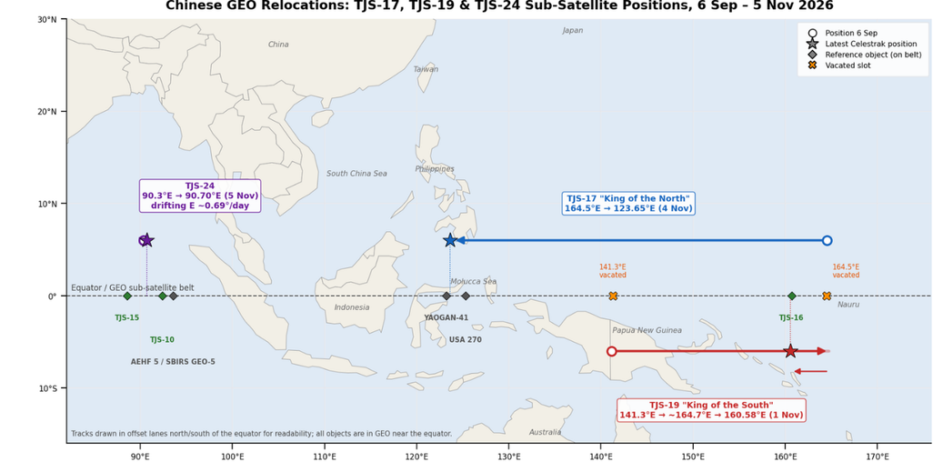
30 Sep – 5 Nov 2026: China has spent the past five weeks rearranging its GEO assets. In Issue 155 we watched TJS-17 (King of the North) (63524) and TJS-19 (King of the South) (63924) drift toward one another from opposite directions and wrote, “we don’t know the destination yet.” We do now. TJS-17 parked over the Molucca Sea at ~123.6°E, TJS-19 overshot TJS-17’s old slot, doubled back, and eventually settled at ~160.6°E right alongside TJS-16 (King of the East) (63397). And just as the Kings were finding their new seats, TJS-24 (69235) (not a member of the Royal Family), which had quietly station-kept at ~90.3°E since June, fired its thrusters on 5 Nov and headed east. China describes the mission for each of these satellites as “mainly used to verify multi-band and high-speed satellite communication technology.”
King of the North Heads West (TJS-17)
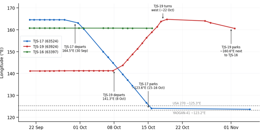
TJS-17 had held ~164.5°E (above the Pacific, just west of Nauru) since its August 2025 relocation (Issue 128). On 30 Sep 2026 China raised the satellite’s SMA ~148 km; a second burn on 1 Oct raised it another ~55 km, leaving TJS-17 ~203 km above GEO and drifting west at ~2.6°/day. From 5–15 Oct the satellite covered ~26° of longitude.
China stopped the drift with two burns: 15–16 Oct to park TJS-17 at ~123.58°E. The Celestrak record has a gap from 15 Oct to 4 Nov; the 4 Nov element set places TJS-17 at 123.65°E with an SMA just 1.5 km above GEO (a slow westward drift of ~0.02°/day). Its current location is due south of the Philippines and Taiwan.
King of the South Heads East…Then West (TJS-19)
TJS-19 had parked at ~141.3°E since May 2025 (Issue 121) and was the only King that did not move during the August 2025 shuffle (Issue 128). This changed on 8 Oct 2026 when China conducted two burns to lower its SMA ~197 km and start an eastward drift of ~2.5°/day. As reported in Issue 155, TJS-17 and TJS-19 crossed paths 8–9 Oct near 141–142°E at ranges of ~400–450 km.
From 16–18 Oct a series of burns raised TJS-19’s SMA ~146 km, slowing its eastward drift to ~0.6°/day near 164.7°E. Celestrak has no elements from 18–26 Oct. COMSPOC reports TJS-19 reached 167.3°E and burned again on 22 Oct to drift back west at ~0.85°/day, which is consistent with the 26 Oct Celestrak SMA of ~66 km above GEO (~0.8°/day west). COMSPOC called this “an interesting use of fuel, possibly a correction for an overshoot.” It does look like an overshoot: TJS-19’s final stop was not TJS-17’s old slot at 164.5°E.
On 29–30 Oct China reduced the westward drift to 0.04°/day near 160.7°E. The 1 Nov Celestrak element set shows TJS-19 at 160.58°E with an SMA 2.3 km above GEO.
The King of the South Joins the King of the East
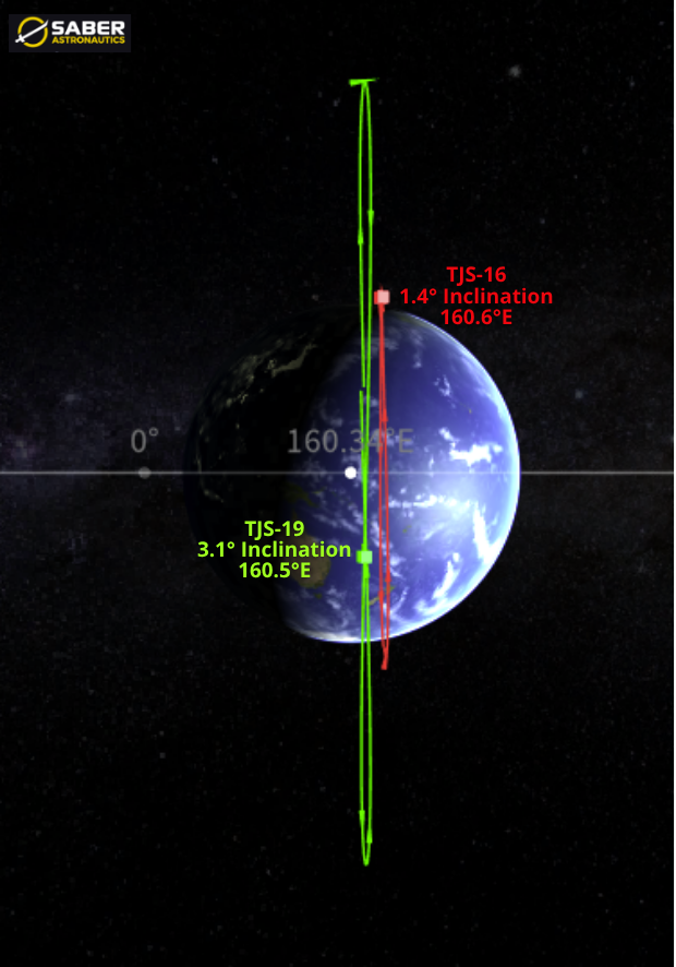
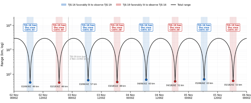
TJS-16 has held 160.5–160.7°E since August 2025 (Issue 128); its most recent element set in our data (15 Oct) places it at 160.69°E. TJS-19 is now roughly 0.1° (~75 km) away in longitude. Since 30 Oct the two satellites have had twice-daily close approaches. One of these, at ~0630Z each day, places TJS-19 ~20 km radially below TJS-16, under TJS-16’s nadir, with favorable lighting.
The orbital planes tell an important part of the story. Using Celestrak elements, TJS-16 (inclination 1.40°, RAAN 80.4°) and TJS-19 (inclination 3.07°, RAAN 320.0°) have a relative inclination of ~4.0°. That means TJS-19 swings roughly ±2,900 km north and south of TJS-16 every day and crosses TJS-16’s orbital plane twice daily; those plane crossings are the twice-daily close approaches. At ~210 m/s of relative velocity during each crossing, TJS-19 spends only ~8 minutes within 100 km (cross-track) of TJS-16 per pass. This is a repeated “drive-by,” not a co-planar formation.
TJS-24 Breaks Pattern of Life
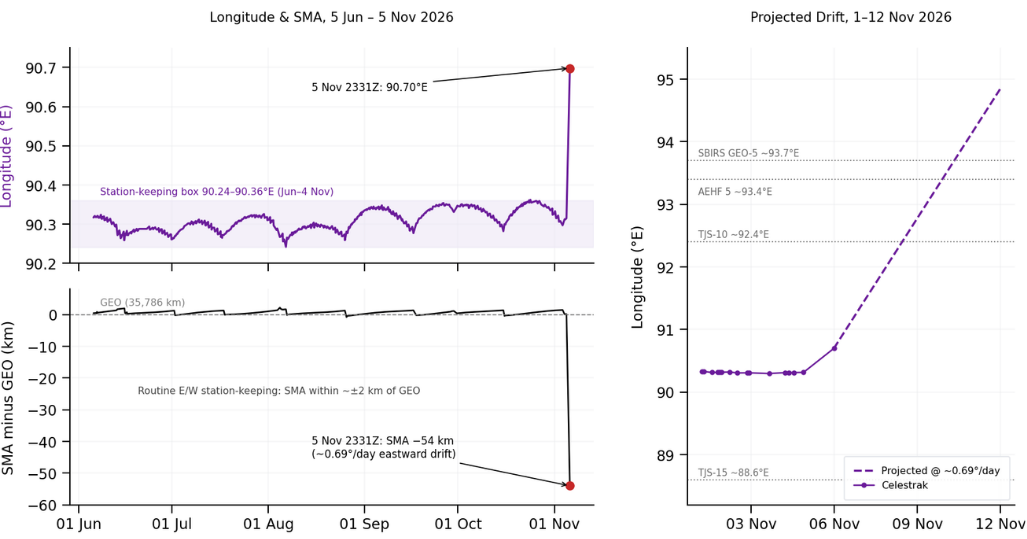
China launched TJS-24 on a LM-7A from Wenchang on 26 May 2026 (Issue 146) and parked it at 90.3°E on 5 Jun (Issue 147). For five months Celestrak data show textbook east/west station-keeping: the satellite stayed between 90.24–90.36°E with routine SMA adjustments every ~2–3 weeks (15–16 Jun, 1 Jul, 17 Jul, 5–6 Aug, 26 Aug, 17 Sep, 30 Sep, 15 Oct, and 4 Nov). The latest cataloged element set (4 Nov 2113Z) places TJS-24 at 90.32°E. Notably, what appears to be another routine station-keeping adjustment occurred ~0513Z on 4 Nov, less than 24 hours before the relocation.
On 5 Nov TJS-24 conducted two burns, the first at 0430Z from 90.48°E (1.74 m/s, initiating a 0.30°/day eastward drift) and the second at 1403Z from 90.51°E (0.89 m/s), increasing the drift to ~0.64°/day east. We’ll wait to see when and where TJS-24 eventually parks and will report later.
China: Creating a New LEO ISR Constellation
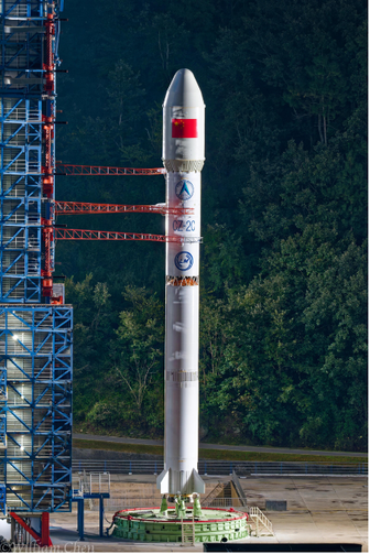
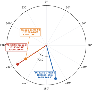
5 Nov 2026: China launched a Long March-2C with the Yaogan-51 07-09 (101283–101285) satellites from Xichang. According to official sources, the satellites have successfully reached the desired orbits. The first element sets put all three satellites at ~518 km and 45.0° inclination, the same shell occupied by the twelve YG-53/56 satellites, and in the same orbital plane as YG-53/56 Group 2. Launch Video. (Note the video mistakenly reports the launch site as Jiuquan instead of Xichang. Chinese press reported launch from Xichang, so I went with that.)
Same Plane, Different Ride
- The new YG-51 satellites have a RAAN offset of only 0.08° with the six YG-53/56 Group 2 (101151, 101152, 101153, 101157) satellites. Both groups are inclined 44.99–45.00° and are within 2 km in average altitude.
- YG-53/56 Group 1 (100651–100656) remains 72.0° west of Group 2 (and now YG-51 07-09).
This is very unlikely to be a coincidence. YG-51 launched from a different site (Xichang vs. Jiuquan) and on a different rocket (LM-2C vs. LM-4B). Landing within ~0.1° of an existing plane means launching at a specific minute. Landing at the same altitude and inclination as well tells us China chose this orbit deliberately.
All 15 satellites continue to maneuver and have yet to settle into a recognizable formation. We’ll continue to track.
China: Qianfan Conducts 2nd Commercial Launch
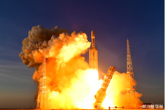
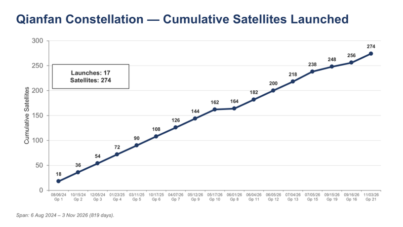
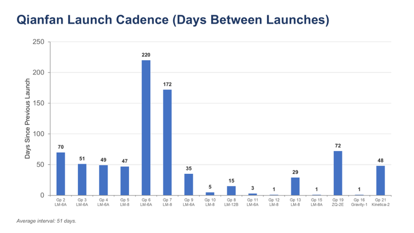
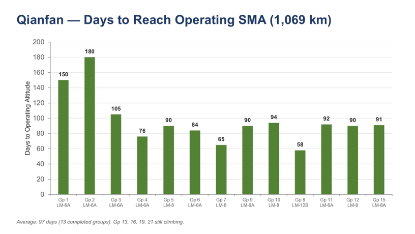
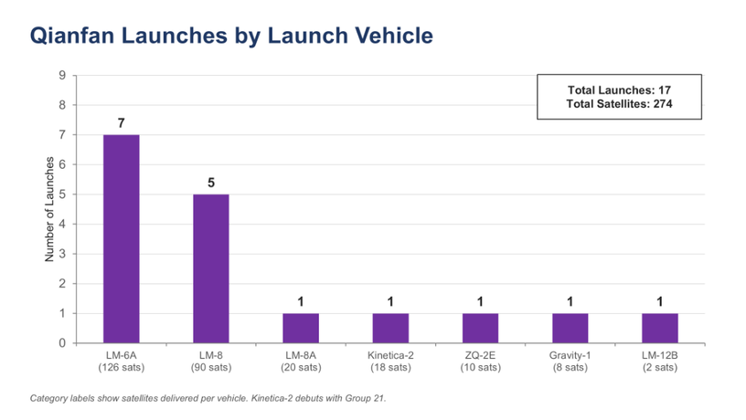
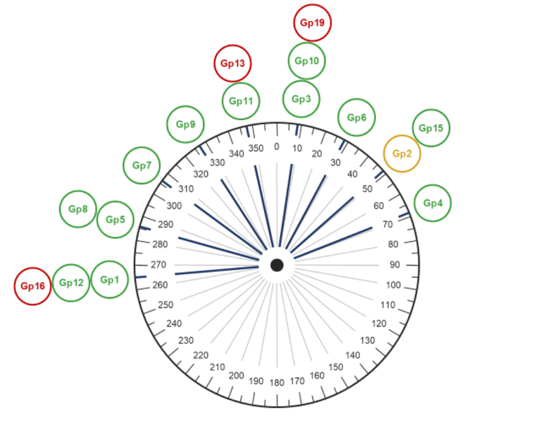
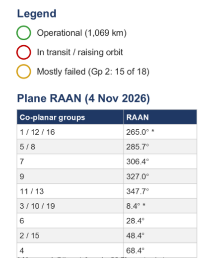
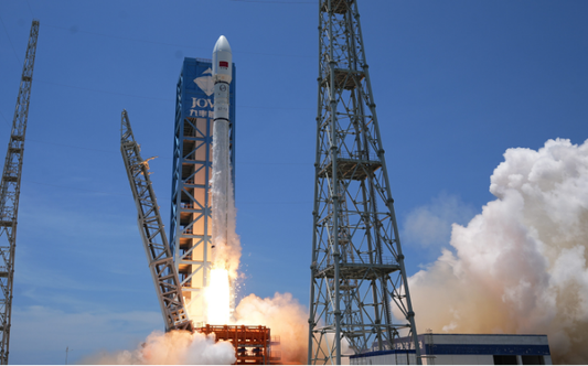
3 Nov 2026: China launched second Kinetica-2 (Lijian-2) launch vehicle with 18 SpaceSail satellites (Qianfan) (101264–101281) from Jiuquan. According to official sources, all satellites (designated “Group 21”) have been placed into the desired orbits and are operating normally. Group 21 has a slight east RAAN offset with Group 9. This offset will disappear as Group 21 increases its SMA from ~800 km to 1,068 km and is integrated with Group 9. Launch Video.
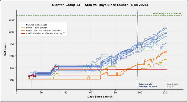
Two analytic notes: Since our last Qianfan report, all 20 satellites from Group 15 (69848–69847) have made it to their operational orbit of 1,068 km after ~91 days. Group 13 satellites (launched 1 day prior to Group 15; there is no Group 14) are taking longer than expected to reach 1,068 km, and it appears one of them (69810) may have failed (see graphic). Group 13 is now at day 121 (as of 2 Nov) and is climbing about 4–5 km/day, so it should arrive around day 130–135 (mid-November). Only Groups 1 (150 days) and 2 (180 days) were slower. Even with the delay, Group 13 satellites will arrive at their operational orbits and will have a RAAN offset of −0.9 to −1.0° with Group 11.
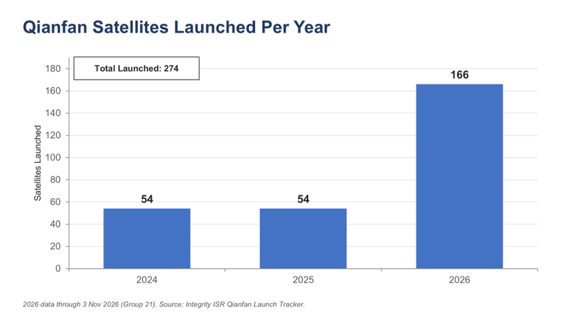
Overall, there are now 274 Qianfan satellites in orbit; 199 have reached 1,068 km, 22 have failed and 53 remain in transit.
Qianfan By The Numbers
Deploying Guowang: A Closer Look at Groups 22 & 23
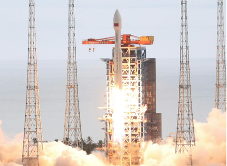
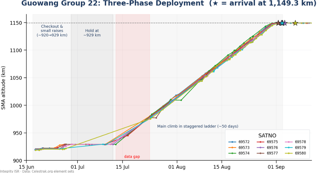
30 Oct 2026: In our description of the Guowang Group 28 launch we noted China used the improved LM-8A for the third time. I thought it would be interesting to take a closer look at how China maneuvers each satellite to space them out equally and co-planar (and also see how well they are doing it). What follows is a comparison of satellites from Guowang Groups 22 & 23. Both launches achieved the same result, nine satellites in their 1,149.3 km, 50.0° operating orbit, but took different paths to get there. Group 22 (69572-69580), launched on a Long March-12 on 17 Jun 2026, began its climb ~230 km below the operating altitude and needed 76–81 days to reach station. Group 23 (100203-100211), launched on an improved Long March-8A on 4 Aug 2026, started only ~50 km low and was fully on station in just 28 days. Spoiler alert: China is good at this; all satellites reached operating orbits and are equally spaced.
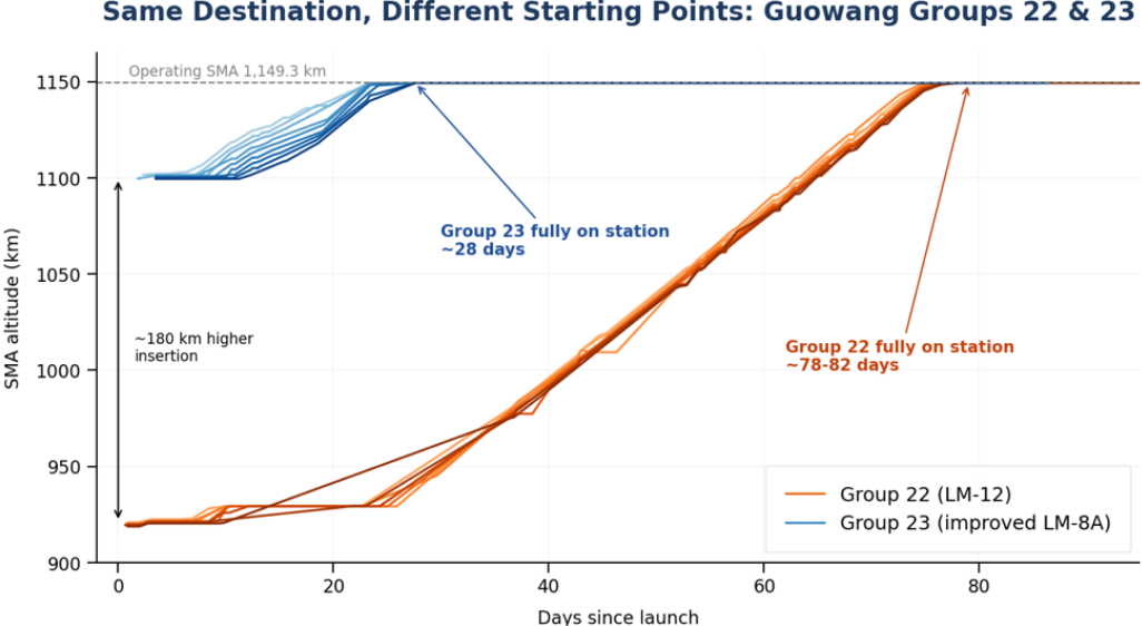
Quest for 1,149.3km
For their 50° inclined orbit planes the Guowang’s desired SMA is 1,149.3 km. As you all recall from Jack’s 10:1 article, a satellite in a lower orbit travels faster than one higher up. At Guowang’s altitudes, every kilometer of SMA difference is worth roughly 1° per day of along-track drift. By orbiting their satellites at slightly different SMAs, China spreads the 9 satellites around their orbital plane without spending propellant on dedicated phasing burns: each satellite climbs on a slightly different schedule, and the ones that linger low drift ahead. When all nine reach the same SMA, the drift stops and their spacing remains constant. In both groups, China staggered the release of each satellite from the launch vehicle’s upper stage so the fan-out started at separation.
Group 23: A Two-Step Ladder
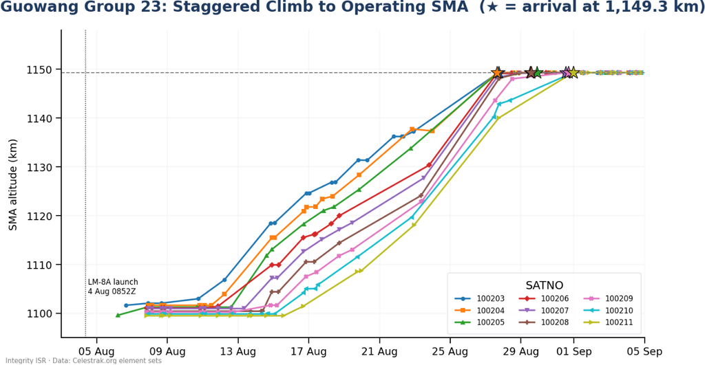
- Rolling climb: Chinese space operators raised the orbit of 100203 first (~10 Aug); 100211 waited until 16 Aug. Climbs were sequenced from highest initial SMA to lowest.
- First on station: 100204 reached 1,149.3 km on 27 Aug at 1542Z, two hours ahead of 100203. Three more arrived on 29 Aug and the final four by late 31 Aug.
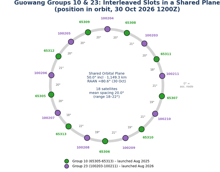
- Result: Our reconstruction places the nine satellites an average of 40° apart (360 ÷ 9), with 100211 (the last to climb) leading the group.
- Fine tuning: Small SMA trims since (100203 ~40 m in late Sep; 100205/100206 ~20 m in late Oct) are slot maintenance, not repositioning.
Group 22: A Three-Step Ladder
- Phase 1 – Checkout (17–29 Jun): The satellites were released at ~919–921 km. Two small raises took most of them to ~929 km by 27–29 Jun.
- Phase 2 – Hold (~29 Jun–12 Jul): The group then sat at ~929 km for roughly two weeks. At that altitude, the orbital plane drifts (precesses) ~0.4° per day faster than at the operating altitude. That is consistent with our Issue 151 assessment that China was timing Group 22’s arrival to coincide with it becoming co-planar with Group 2.
- Phase 3 – Main climb (~12 Jul–3 Sep): All nine climbed ~220 km over ~50 days. Through August the SMAs again formed a ladder.
- Arrival: 69577 reached 1,149.3 km first, on 1 Sep at 1355Z, followed within an hour by 69574 and 69573. Four more arrived on 2 Sep, and 69576 on 3 Sep. 69580 was at 1,149.27 km on 3 Sep; the next element set (6 Sep) shows it on station.
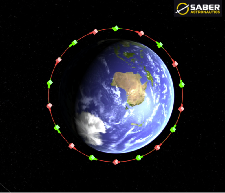
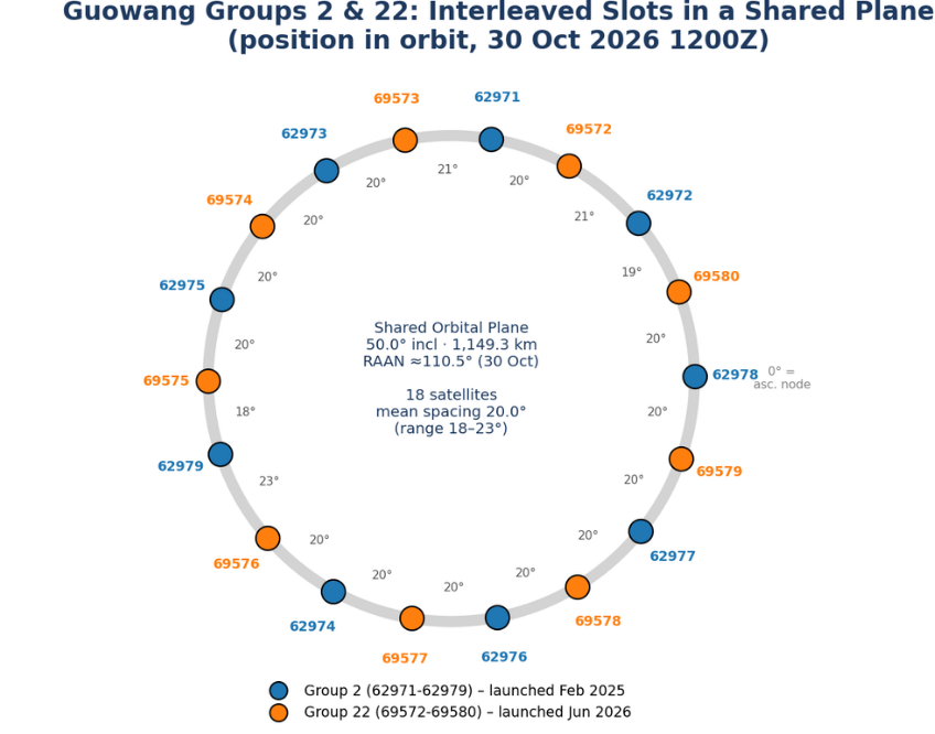
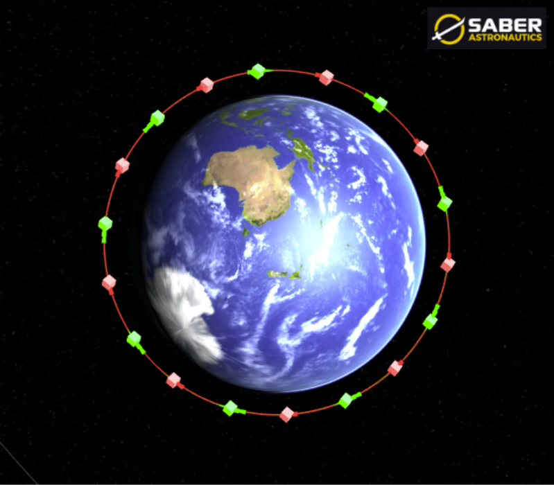
Slot positions: As with Group 23, China separated each Guowang satellite ~40° apart. As expected, China was able to interleave these satellites with Group 2 (launched 11 Feb 2025). The result is 18 satellites at ~20° spacing.
Why the improved LM-8A matters
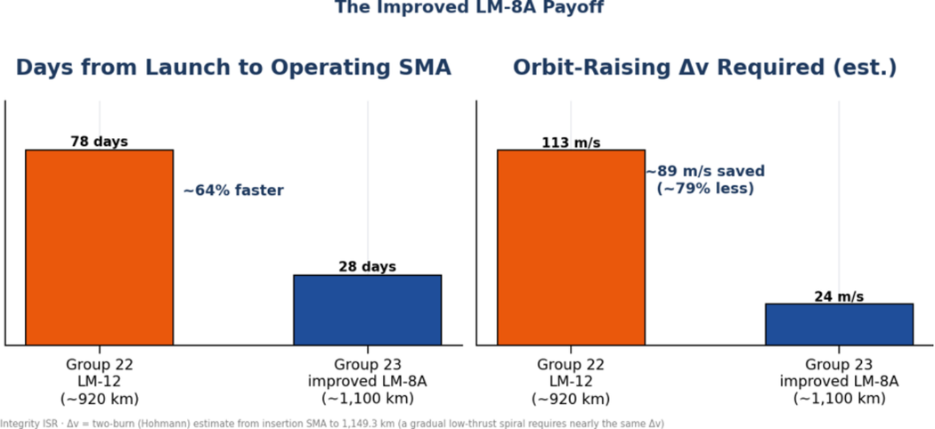
Time to service. Group 23 reached full operating capability ~50 days sooner than Group 22 and ~57 days sooner than the ~85-day average for other 50° Guowang groups. The climb rate itself was comparable (~3–4.5 km per day for both groups), so nearly all of the savings come from starting ~180 km higher. Launching Group 23 almost directly into the plane it was meant to occupy (~1° west of Group 10) also removed the need for the kind of extended plane-alignment hold Group 22 used.
Propellant and lifetime. Raising a circular orbit from ~920 km to 1,149.3 km costs roughly 113 m/s of Δv; from ~1,100 km it costs ~24 m/s, about 89 m/s, or ~79%, less. Earlier LM-8A groups delivered to ~870 km would have needed ~139 m/s. At 1,149 km, atmospheric drag is negligible, so propellant that is not spent climbing remains available for collision avoidance, slot maintenance and end-of-life disposal. That margin could extend a satellite’s service life or improve its odds of a controlled disposal; how much depends on each satellite’s propellant load and thruster type, which China has not disclosed.
| Group 22 | Group 23 | |
|---|---|---|
| Launch | 17 Jun 2026, LM-12, Wenchang | 4 Aug 2026, improved LM-8A, Wenchang |
| Insertion SMA | ~919–921 km | ~1,099–1,102 km |
| Altitude to climb | ~230 km | ~50 km |
| Plane | Co-planar with Group 2 | Co-planar with Group 10 |
| First satellite on station | 1 Sep (69577, day 76) | 27 Aug (100204, day 23) |
| Last satellite on station | 3–6 Sep (69580, day 78–81) | 31 Aug (100210, day 28) |
| Orbit-raising Δv (est.) | ~113 m/s | ~24 m/s |
Editor’s Comment
Groups 22 and 23 show the same playbook executed from two different starting points. The improved LM-8A shortens the ladder: satellites start delivering coverage nearly two months sooner and keep most of the propellant they would otherwise burn climbing.
Four Years of Change: Revisiting DIA’s Challenges to Security in Space
by Alison Sayer
Four years after its last assessment, the Defense Intelligence Agency (DIA) has released the 2026 edition of Challenges to Security in Space, offering an updated assessment of how adversary space capabilities and the counterspace threat environment have evolved. The third in a series beginning in 2019, the latest report examines many of the same threats identified in its 2022 predecessor. However, the intervening four years have brought significant developments in the scale of space operations, the sophistication of counterspace capabilities, and the growing role of commercial space systems in military conflict.
China: Expanding Capabilities and Operations
China’s expanding space program was a central concern in DIA’s 2022 assessment, which documented Beijing’s investments in military space capabilities, satellite constellations, and counterspace weapons. The 2026 report illustrates the continued pace of that expansion. According to DIA, China conducted 93 space launches in 2025, compared with 22 in 2016, while the number of satellites deployed annually increased from 40 to 384 over the same period. Beijing has also continued launching satellites for its proliferated low Earth orbit (LEO) constellations, expanding its communications and intelligence, surveillance, and reconnaissance (ISR) capabilities.
One notable change in DIA’s public assessment concerns China’s electronic warfare (EW) capabilities. While the 2022 edition described Chinese satellite jamming systems and efforts to develop capabilities targeting synthetic aperture radar (SAR) and protected satellite communications, the 2026 report explicitly identifies both ground-based and on-orbit jamming systems among the People’s Liberation Army’s (PLA) capabilities. The assessment cites research examining Chinese military technical publications describing experimentation with an orbital jamming system as early as 2020. Although DIA does not identify specific operational spacecraft or provide details of their employment, the inclusion of on-orbit jamming represents a more explicit characterization of China’s counterspace capabilities.
China’s on-orbit activities also demonstrate advances in technologies with potential counterspace applications. In 2023, China’s TJS-3 spacecraft repeatedly approached within 10 kilometers of other nations’ satellites in geosynchronous Earth orbit (GEO). In January 2025, China launched Shijian-25, which Beijing claims will test orbital refueling and servicing capabilities. While these activities may serve legitimate purposes, the technologies involved could also support operations against other spacecraft. DIA further assesses that China may field space-based directed-energy systems and more powerful ground-based lasers by the late 2020s, potentially expanding its ability to threaten satellites in higher orbits.
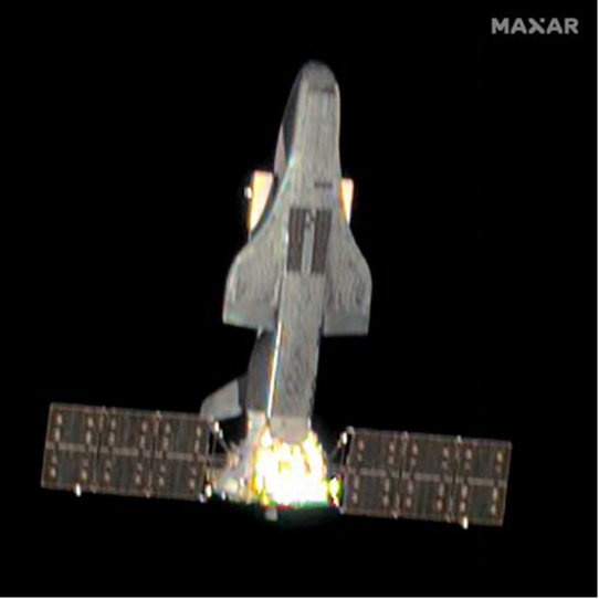
2024 Image of China’s Shenlong Space Plane (DIA Challenges to Security In Space 2026).
Russia: Counterspace Capabilities in Conflict
DIA’s 2022 assessment highlighted Russia’s development of electronic warfare, directed-energy weapons, and kinetic antisatellite (ASAT) capabilities, including its November 2021 destructive ASAT test. Four years later, the 2026 report provides specific examples of Russian counterspace operations during the war in Ukraine, alongside concerns about potentially more destructive systems.
On February 24, 2022, immediately before Russia’s full-scale invasion of Ukraine, Russian malware targeted Viasat’s satellite communications network, disrupting service for approximately 50,000 users across Ukraine and other European countries.
Russian forces have also employed electronic warfare systems to interfere with satellite communications and navigation services, including GPS. DIA reports that Russia has targeted commercial satellite constellations supporting Ukrainian military operations with jammers, demonstrating how space-enabled services can be disrupted without physically destroying satellites.
The 2026 report also identifies Russia’s development of a satellite designed to carry a nuclear weapon, despite the prohibition on placing nuclear weapons in orbit under the 1967 Outer Space Treaty. DIA assesses that such a capability could rapidly degrade or destroy thousands of satellites, disrupting communications, navigation, and other critical services. A nuclear detonation in space could also create radiation belts that persist for years, potentially damaging satellites that initially survived the event.
An Increasingly Complex Space Environment
Beyond individual Chinese and Russian capabilities, the two reports illustrate broader changes in the space environment. DIA’s 2022 assessment emphasized expanding commercial participation, increasing orbital congestion, and growing dependence on satellite services. The 2026 report places greater emphasis on the operational role of commercial space capabilities and their vulnerability during conflict.
The war in Ukraine has demonstrated the value of commercial satellite communications and imagery to military operations, while exposing those same services to electronic warfare and cyberattacks. DIA also identifies expanding space-related cooperation among China, Russia, Iran, and North Korea. Since 2022, Russia has launched two remote-sensing satellites for Iran, while China has provided space-related components and services to Russia. These relationships demonstrate how international partnerships can support national space capabilities and potentially influence military operations.
The increasing availability of commercial space services further complicates the operating environment. Capabilities once largely limited to government programs are becoming accessible to a wider range of state and non-state actors, expanding both the benefits of space access and the potential threats to space-enabled services.
Looking Ahead
A comparison of DIA’s 2022 and 2026 assessments reveals a space threat environment shaped by the continued expansion of adversary capabilities, demonstrated counterspace operations, and the development of potentially more destructive weapons. China’s growing satellite fleets, DIA’s more explicit discussion of on-orbit electronic warfare, and Russia’s employment of counterspace capabilities in Ukraine illustrate different aspects of this evolution.
While many of the underlying threats were already identified in 2022, the developments documented in the latest report highlight the increasing complexity of protecting space systems and the services they provide. As military operations and commercial infrastructure become more dependent on space, the consequences of disrupting those systems will continue to extend well beyond the space domain.
Cyber Series Part 5 - Losing the Link: What happens when a satellite loses its connection to Earth?
By Dr. Larissa Beavers
More Than a Lost Signal
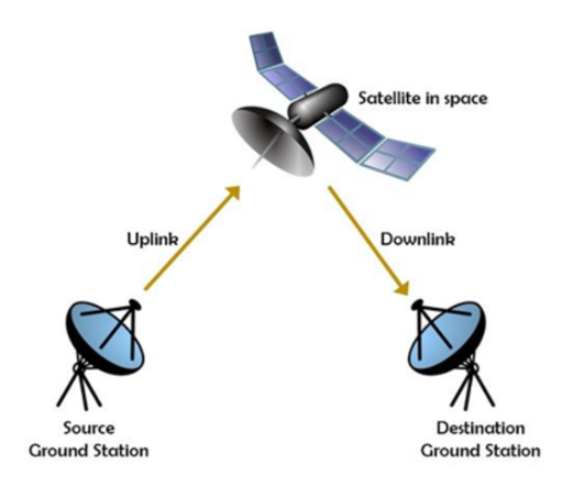
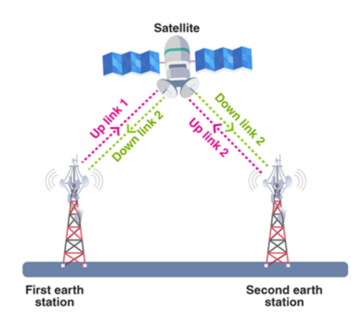
Satellite communications operate in two directions (Figures 1 and 2). The uplink carries commands from ground operators to the spacecraft, while the downlink returns telemetry and mission data. Telemetry provides information about spacecraft health, equipment status, temperatures, battery conditions, and the results of previously issued commands. These exchanges support an ongoing process. Operators evaluate the spacecraft’s condition, prepare commands, and use returned telemetry to determine whether those commands produced the intended results.
NASA identifies command link jamming and command link intrusion as potential counterspace threats. Command link jamming uses radio frequency interference to prevent legitimate commands from reaching the spacecraft. Command link intrusion presents a different threat: unauthorized commands that pass the spacecraft’s encryption or authentication protections could result in a temporary or permanent loss of control.
The downlink introduces another concern. As described in The Aerospace Corporation’s SPARTA framework, attackers may attempt to disrupt or manipulate telemetry returned to ground operators. Unlike jamming, which can prevent communications, telemetry manipulation may leave the link functioning while providing operators with an inaccurate picture of spacecraft conditions.
A received signal, therefore, tells operators that information has arrived, not necessarily that the information is accurate.
When Telemetry Cannot Be Trusted
Consider a satellite that communicates with a ground station during scheduled contact windows. During one pass, operators receive telemetry indicating that the spacecraft’s battery and thermal systems are operating normally. Once the satellite moves beyond the station’s coverage, the operations team reviews those readings and prepares commands for the next contact.
Now suppose an attacker has altered the telemetry before it reaches the operators. The reported temperatures might conceal a developing equipment problem, or the battery readings might falsely indicate that corrective action is needed.
Between contact windows, the operations team could prepare commands based on those misleading readings. When communications resume, those commands might be inappropriate for the spacecraft’s actual condition.
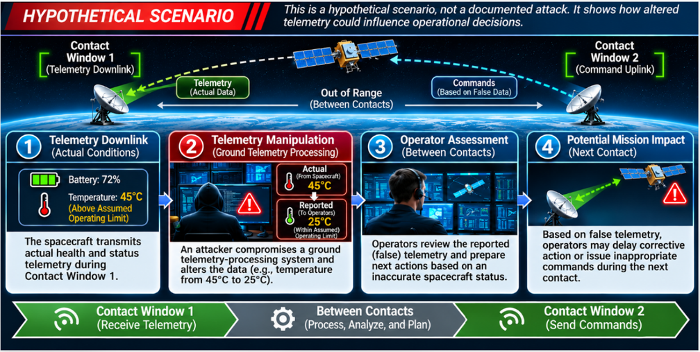
Figure 3: Hypothetical telemetry-manipulation scenario illustrating how an attacker compromising a ground telemetry-processing system could alter spacecraft health data, influence operator assessments between contact windows, and potentially affect commanding during a subsequent contact. This illustration does not represent a documented cyberattack.
Figure 3 is a hypothetical example illustrating how false telemetry could influence legitimate operators without an attacker directly commanding the spacecraft. The source of the manipulation matters. False data could be introduced through a compromised onboard system, an inadequately protected communications path, or ground software that processes and displays telemetry. Each would require different access and present different opportunities for detection.
Contact windows can complicate the situation. For spacecraft relying on intermittent direct-to-Earth communications, operators may have to wait until the next pass to request additional information or confirm a suspected anomaly. Other missions use relay networks or more continuous communications, reducing some of these delays. The result is a different kind of operational risk. The spacecraft may continue functioning, but the people responsible for operating it may be making decisions from an inaccurate picture of its condition.
Protecting Both Directions
Protecting satellite communications requires attention to both the commands sent to the spacecraft and the information returned to Earth. Command authentication helps establish that instructions originate from an authorized source. Integrity protections help detect unauthorized changes, while encryption protects the confidentiality of information transmitted across a link. Authenticated encryption can combine these protections.
NASA’s Space System Protection Standard (NASA-STD-1006A) establishes requirements for protecting spacecraft command systems, including encryption and authentication measures to prevent unauthorized commanding. However, it is important to note that NASA’s 2026-STD 1006A includes relevant exceptions for certain Category 3/Class C or D spacecraft without propulsion; these spacecraft may use authentication without encryption, subject to the standard’s tailoring provisions.
These protections are particularly important because command link intrusion may involve commands that appear valid to the spacecraft. Protecting command authority, therefore, requires securing not only the communications link but also the systems and credentials used to generate and authorize commands.
The downlink deserves particular attention because spacecraft telemetry informs operational decisions. Even when telemetry does not require confidentiality, operators may still need assurance that the data came from a trusted source and was not modified in transit.
These protections must extend beyond the radio link itself. Authentic telemetry can still be misrepresented if the onboard source is compromised or ground software alters the data after reception. Communications security, therefore, works alongside software integrity, access controls, and operational checks.
The required protections also depend on the mission. A satellite without propulsion may face different consequences from unauthorized commands than a maneuverable spacecraft, but it still relies on trustworthy commanding and telemetry.
A Growing Challenge for Constellations
Protecting one spacecraft’s communications is already a technical and operational responsibility. Managing trusted communications across a constellation introduces additional complexity.
Some constellations use inter-satellite links to exchange data (e.g., Figure 5) or route communications between spacecraft. Depending on the architecture, operators may need to secure ground links, crosslinks, and payload-related communications while maintaining the cryptographic keys used to authenticate or encrypt those exchanges.
Cryptographic keys (explored more in part 6) must remain valid and accessible to the systems authorized to use them. According to the Consultative Committee for Space Data Systems (CCSDS), managing these keys includes maintaining their operational lifetime and securely updating or replacing them when necessary. If the required keys become unavailable, expire, or are compromised, a spacecraft may be unable to establish or maintain protected communications, even when its communications hardware remains operational.
The complexity of key management depends on the network’s design and security requirements. For operators, the challenge is maintaining secure communications as spacecraft move, connections change, and cryptographic keys require updating across the constellation.
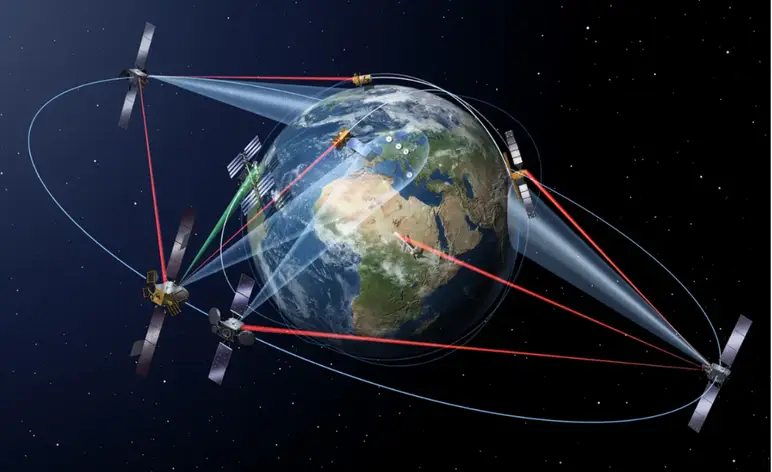
Figure 5: ESA depiction of ESA intersatellite laser links.
Losing a satellite link disrupts operations, but receiving misleading information can be harder to detect. As constellations expand, maintaining trusted communications becomes increasingly challenging across multiple spacecraft and interconnected links.
Coming in Part 6: The Key to the Constellation. How do operators maintain secure communications when satellites must exchange data with ground stations, neighboring spacecraft, and mission systems? Next, we examine the growing challenge of encryption and key management across satellite constellations.
Acknowledgements: Special thanks to Mr. David Merritt for your valuable feedback and technical insights, which helped guide the direction and development of Parts 5 and 6 of the series.
Pics o’ the Fortnight!
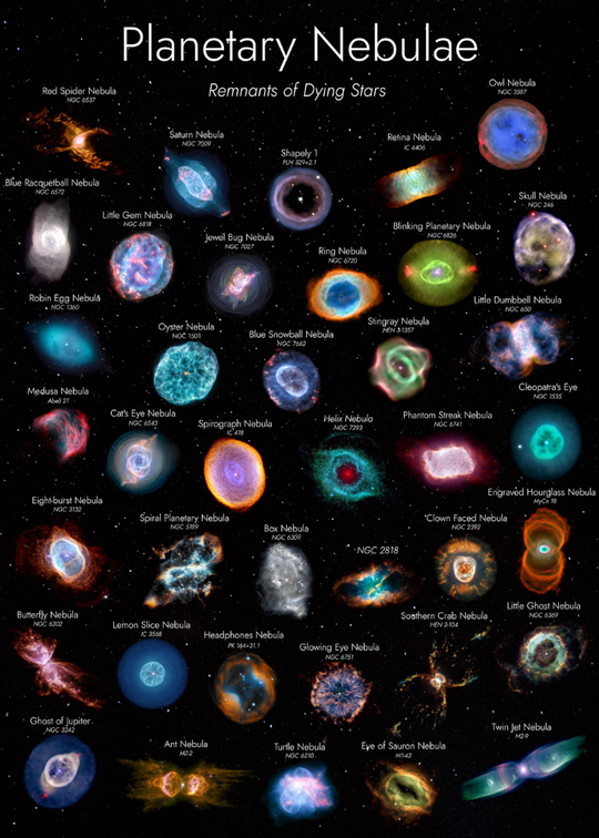
Planetary Nebulae (@uhd2020).

Dawn on Mars: what a photograph! Wind-carved Martian cliffs, taken at 8:30 a.m. local Mars time by the @NASA Curiosity rover (@Cmdr_Hadfield via X).
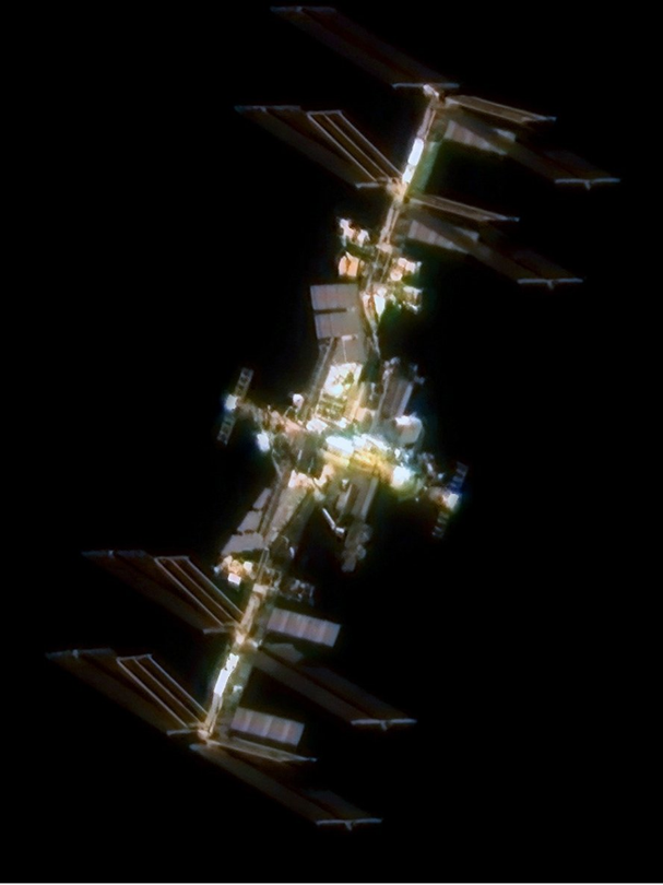
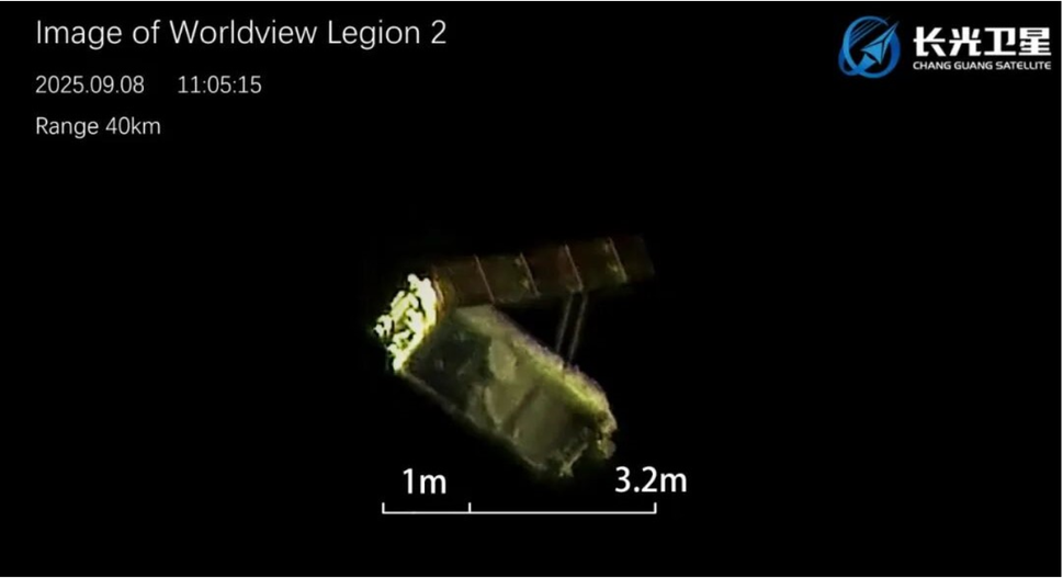
ChangGuang demonstrated their Non-Earth Imaging capability by releasing images of ISS (left) and Maxar’s Worldview Legion 2 (below) in 2025 (@CNSpaceflight via X).